



Moss Point, Mississippi
Moss Point is a city of 11,957 people in Jackson County, Mississippi.
Why visit Moss Point
Townapedia lists 9 museums and landmarks, 12 parks and trails, 50 places to eat, 15 places to stay and 3 attractions in and around town.
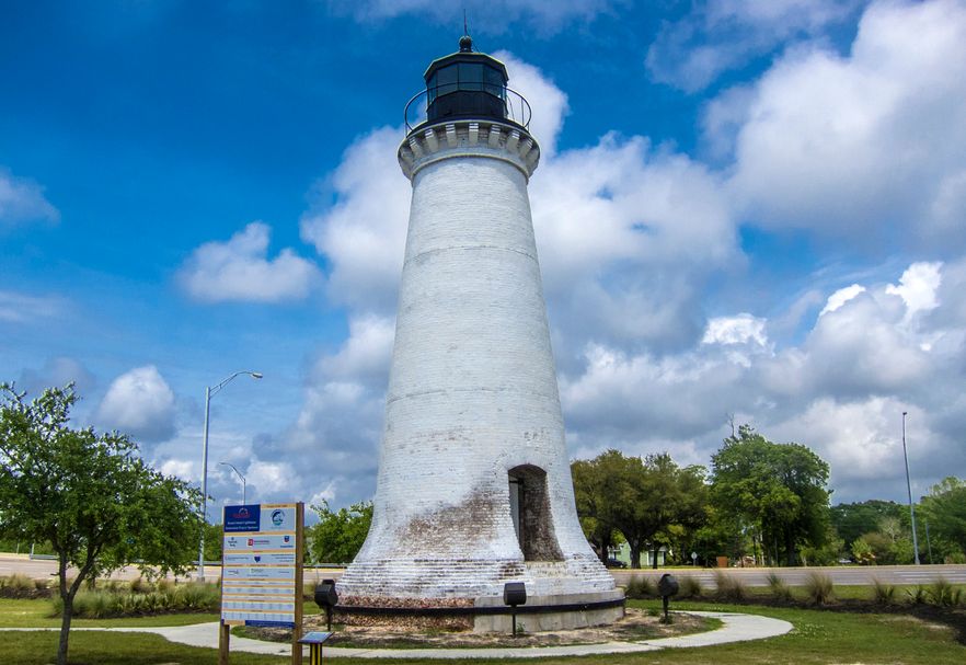
Highlights include Round Island Light, East Pascagoula River Light, Bellevue and Griffin House.
July is the warmest month, with average highs of 91°F; January lows average 41°F.
Weather in Moss Point
Forecast from the National Weather Service. Full forecast
About Moss Point
Moss Point is a city in Jackson County, Mississippi, United States. The population was 12,147 in 2020, a decline from the figure of 13,704 in 2010. The Moss Point Historic District and several individual buildings are listed on the National Register of Historic Places' Jackson County listings.
From the Wikipedia article Moss Point, Mississippi (this version), under CC BY-SA 4.0.
Things to do3
Round Island Light
Lighthouse · National Register of Historic Places · 4.1 mi
Lighthouse in Mississippi, United States

East Pascagoula River Light
Lighthouse · 5.7 mi
Lighthouse in Mississippi, United States

Pascagoula River High Rise Bridge
Bridge · 4.1 mi
Bridge in United States of America
Museums and landmarks9

Bellevue
Monument and historic site · National Register of Historic Places · 5.6 mi
Historic home in Pascagoula, Mississippi, United States

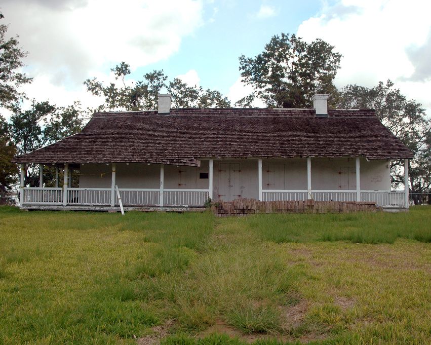
Griffin House
Monument and historic site · National Register of Historic Places · 1.6 mi
House in Moss Point, Mississippi

Old Pascagoula High School
Monument and historic site · National Register of Historic Places · 4.6 mi
High school in Mississippi, United States
Old Spanish Fort
Museum · National Register of Historic Places · 3.5 mi
Historic house in Mississippi, United States

Pascagoula station
Monument and historic site · National Register of Historic Places · 4.3 mi
Train station in Pascagoula, Mississippi, USA serving Amtrak

St. Mary's By the River
Monument and historic site · National Register of Historic Places · 2.4 mi
Historic house in Mississippi, United States


Pascagoula Central Fire Station No. 1
Monument and historic site · National Register of Historic Places · 4.3 mi
Parks, trails and playgrounds12

Restaurants and cafes50


Four K's Coastal Grill
Restaurant · 3.9 mi
2102 Denny Avenue, Pascagoula
Mo-Th 10:00-14:00; Fr-Sa 10:00-14:00,16:00-20:00; Su 10:00-14:00
Brady's Steak and Seafood
Restaurant · Seafood · 4.0 mi
3801 Magnolia Street, Pascagoula
Su-Th 11:00-21:00; Fr-Sa 11:00-22:00
Brady's Steaks and Seafood
Restaurant · Seafood, Steak · 4.0 mi
3801 Magnolia Street, Pascagoula
Su-Th 11:00-21:00; Fr-Sa 11:00-22:00
Sakura Express
Restaurant · Sushi, Hibachi · 3.4 mi
3141 Denny Avenue
Mo-Th 11:00-21:30, Fr-Sa 11:00-22:00
38 more on the map.
History
Moss Point is home to Trent Lott International Airport and the Mississippi Export Railroad.
On August 29, 2005, Moss Point was hit by the strong eastern side of Hurricane Katrina, when it passed 30 miles (48 km) east of central New Orleans with minimal gale-force winds. However, on the east side of Hurricane Katrina, much of Moss Point was flooded or destroyed in one day, by the strong hurricane-force winds which lasted several hours and a storm surge exceeding 20 feet (6.1 m) in some sections.
An EF2 tornado touched down in Moss Point on June 19, 2023 The tornado covered six miles of the city and damaged or destroyed over 300 homes and businesses.
From the History section of Moss Point, Mississippi on Wikipedia, under CC BY-SA 4.0.
Where to stay15
Churches and places of worship53
Saint Joseph Catholic Church
Church · Roman Catholic · 1.9 mi
4114 Pine Street, Moss Point
Shopping6
Gas and EV charging16
Schools, colleges and libraries35
Moss Point Career & Technical Educa
School · 1.5 mi
4913 Weems Street, Moss Point
Healthcare6
Singing River Medical Park
Clinic and pharmacy · 3.4 mi
3101 Denny Avenue, Pascagoula
Map of Moss Point
205 places. The map loads OpenStreetMap tiles when you open it.
Climate by month
Monthly table
| Month | High | Low | Rain |
|---|---|---|---|
| Jan | 62°F | 41°F | 5.0 in |
| Feb | 66°F | 45°F | 4.0 in |
| Mar | 72°F | 50°F | 4.7 in |
| Apr | 78°F | 56°F | 4.4 in |
| May | 84°F | 63°F | 5.0 in |
| Jun | 90°F | 71°F | 6.9 in |
| Jul | 91°F | 73°F | 6.7 in |
| Aug | 91°F | 73°F | 7.9 in |
| Sep | 88°F | 69°F | 4.8 in |
| Oct | 81°F | 58°F | 3.7 in |
| Nov | 71°F | 47°F | 3.8 in |
| Dec | 65°F | 43°F | 4.9 in |
U.S. Climate Normals 1991-2020 for Pascagoula Lott Intl Ap (3 mi away), NOAA NCEI.
People and cost of living
American Community Survey 5-year estimates, 2020-2024, U.S. Census Bureau. Estimates have margins of error, larger for small towns.
Disaster history
Jackson County has had 25 federal disaster declarations since 2000, most often for hurricanes.
- 2026-02-06: Severe Winter Storm (Winter Storm)
- 2026-01-24: Severe Winter Storm (Winter Storm)
- 2023-08-12: Severe Storms, Straight-Line Winds, And Tornadoes. (Severe Storm)
- 2021-10-22: Hurricane Ida (Hurricane)
- 2021-08-28: Hurricane Ida (Hurricane)
- 2020-12-31: Hurricane Zeta (Hurricane)
OpenFEMA disaster declarations summaries.
Getting there and nearby towns
Trent Lott International Airport (PGL) is the nearest airport with scheduled flights listed in OpenStreetMap, 2 miles away.
- Gautier 8 mi west, about 12 min by car
- Tillmans Corner 22 mi northeast, about 35 min by car
- D'Iberville 22 mi west, about 35 min by car
- Biloxi 24 mi west, about 39 min by car
- Mobile 30 mi northeast, about 49 min by car
- Gulfport 32 mi west, about 51 min by car
- Prichard 34 mi northeast, about 54 min by car
- Long Beach 38 mi west, about 1 h by car
- Fairhope 39 mi east, about 1 h by car
- Saraland 39 mi northeast, about 1 h by car
Drive times are estimates from straight-line distance, not routes.
Local news
Headlines from INDB, the NEMICO news database.
Reviews, tips and questions
Loading what members have shared...
Sources and licences
- NCES EDGE (Public domain): public schools
- NOAA NCEI U.S. Climate Normals 1991-2020 (Public domain): climate by month
- OpenFEMA (Public domain): disaster declarations
- OpenStreetMap contributors (ODbL 1.0): places, airports, map data
- U.S. Census Bureau (Public domain): population, income, housing, education, commute
- Wikidata (CC0 1.0): elevation, founding date, time zone, website, landmarks and historic places
- Wikimedia Commons (see each image): photos
- Wikipedia (CC BY-SA 4.0): overview and history text
Photo credits
- Moss Point City Hall Sept 2012, Chris Pruitt, CC BY-SA 3.0
- Moss Point Blues - Mississippi Blues Trail Marker, Firecruise, CC BY-SA 4.0
- Griffin House (Moss Point, Mississippi), Quentin Melson, CC BY-SA 4.0
- Round Island Lighthouse Pascagoula April 2015, FEMA / Christopher Mardorf, Public domain
- OldSpanishFort Pascagoula July 2006, Michelle Miller-Freeck/FEMA, Public domain
- Pascagoula L&N Depot Sept 2012 03, Chris Pruitt, CC BY-SA 3.0
- St. Mary's By the River Nov 2012 2, Chris Pruitt, CC BY-SA 3.0
- Old Pascagoula High School Sept 2012 02, Chris Pruitt, CC BY-SA 3.0
- Pascagoula Central Fire Station No. 1 Sept 2012 01, Chris Pruitt, CC BY-SA 3.0
- Flickr - DVIDSHUB - Mississippi National Guard Special Forces rescue residents post-Hurricane Isaac (Image 5 of 7), DVIDSHUB, CC BY 2.0
- ISS030-E-105966 - View of Earth, Earth Science and Remote Sensing Unit , Lyndon B. Johnson Space Center, Public domain
- CSX8203 Pensagoula loops, kitmasterbloke, CC BY 2.0
- Mississippi Gulf Coast Blues And Heritage Festival, Firecruise, CC BY-SA 4.0
- CSX7572 Orange Grove AL, kitmasterbloke, CC BY 2.0
- Symphyotrichum tenuifolium 53287706, Will McFarland, CC0
- LaPointe Krebs House 1-31-22, J.gadbois, CC BY-SA 4.0
- LaPointe Krebs House -2022 post restoration, J.gadbois, CC BY-SA 4.0
- South Side Exterior 6-2-2015, Mmwixon, CC BY-SA 4.0


Page built October 30, 2026. Spotted a mistake? Tell us or suggest a place.