


Nevada City, California
Nevada City is a city of 3,172 people in Nevada County, California.
Why visit Nevada City
Townapedia lists 28 museums and landmarks, 6 parks and trails, 41 places to eat, 3 places to stay and 5 attractions in and around town.
Highlights include Nevada Theatre, The Onyx Theatre, Nevada City Downtown Historic District and Aaron A. Sargent House.
July is the warmest month, with average highs of 87°F; December lows average 35°F.
Weather in Nevada City
Forecast from the National Weather Service. Full forecast
About Nevada City
Nevada City is a city in and the county seat of Nevada County, California, United States, 60 miles (97 km) northeast of Sacramento, 84 miles (135 km) southwest of Reno and 147 miles (237 km) northeast of San Francisco. The population was 3,152 as of the 2020 census.
From the Wikipedia article Nevada City, California (this version), under CC BY-SA 4.0.
Things to do5

Nevada Theatre
Cinema and theater · National Register of Historic Places · 0.8 mi
Movie theater and former theater in Nevada City, California, United States


Museums and landmarks28

Nevada City Downtown Historic District
Monument and historic site · National Register of Historic Places · 0.8 mi
Historic district in California, United States

Aaron A. Sargent House
Monument and historic site · National Register of Historic Places · 0.7 mi
House in Nevada City, California
Davis Mill
Monument and historic site · National Register of Historic Places · 3.2 mi
Stamp mill in Nevada County, California

Doris Foley Library for Historical Research
Monument and historic site · National Register of Historic Places · 0.8 mi
Public library in Nevada City, California, USA

Grass Valley Public Library
Monument and historic site · National Register of Historic Places · 3.4 mi
Carnegie library in California, United States of America

Martin Luther Marsh House
Monument and historic site · National Register of Historic Places · 1.4 mi
Nevada City, California
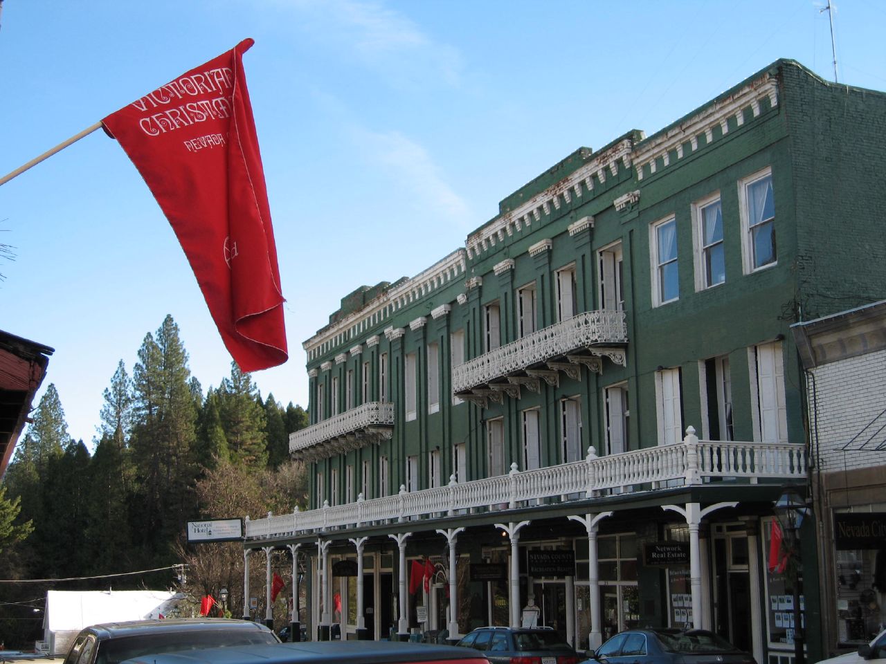
National Exchange Hotel
Monument and historic site · National Register of Historic Places · 0.9 mi
Hotel in California, United States of America

Nevada Brewery
Monument and historic site · National Register of Historic Places · 1.0 mi
Commercial building in Nevada City, United States of America
Nevada City Firehouse No. 2
Monument and historic site · National Register of Historic Places · 0.7 mi
Fire station in California, United States of America

Ott's Assay Office
Monument and historic site · National Register of Historic Places · 1.0 mi
Office building in Nevada City, United States of America


Mount Saint Mary's Convent and Academy
Monument and historic site · National Register of Historic Places · 3.6 mi

16 more on the map.
Parks, trails and playgrounds6


Restaurants and cafes41

Fudenjüce
Restaurant · Coffee Shop, Sandwich, Juice, Regional, Breakfast, Soup, Frozen Yogurt, Brunch · 0.7 mi
815 Zion Street, Nevada City
Mo-Fr 09:00-18:00; Sa-Su 10:00-18:00
Three Forks Bakery and Brewing Company
Restaurant · Pizza, Sandwich · 0.9 mi
211 Commercial Street, Nevada City
Mo,We-Th,Su 08:00-21:00; Tu off; Fr 08:00-22:00


Crazy Horse Saloon & Grill
Bar and pub · Burger, Grill, Local, Sandwich · 0.9 mi
230 Commercial Street, Nevada City
Dutch Bros. Coffee
Cafe · Coffee Shop · 1.5 mi
2094 Nevada City Highway, Grass Valley
Fr-Sa 05:00-23:00; Mo-Th,Su 05:00-22:00; PH closed
Elixart
Cafe · Tea · 0.8 mi
Teas, elixirs, tonics and raw food. Also houses fine art from local artisans and from around the world.
203 York Street, Nevada City
Heartwood
Restaurant · Breakfast, Coffee Shop, Local, Tea, Asian · 0.8 mi
237 Commercial Street, Nevada City
10:00-20:30
Miner Moes Pizza Restaurant
Restaurant · Pizza · 0.7 mi
102 Argall Way, Nevada City
Mo-Fr 11:00-20:00, Sa 11:30-20:00, Su 12:00-20:00

Carrington's Fine Wines
Brewery and winery · 0.8 mi
242 Commercial Street, Nevada City
Th 10:30-17:30, Fr-Sa 11:00-19:00
29 more on the map.
History
The settlement was originally a Nisenan village named Ustumah.
European Americans first settled Nevada City in 1849, during the California Gold Rush, as Nevada (Spanish for "snow-covered", a reference to the snow-topped mountains in the area). Chinese immigrants as well as free and enslaved Black Americans also settled in the area during the Gold Rush. The town was later called Deer Creek Dry Diggins, and Caldwell's Upper Store. The Gold Tunnel on the north side of Deer Creek was the city's first mine, built in 1850. The first sawmill in Nevada City was built on Deer Creek, just above town, in August 1850, by Lewis & Son, with a water wheel. In 1850–51, Nevada City was the state's most important mining town, and Nevada County the state's leading gold-mining county. In 1851, The Nevada Journal became the first newspaper published in the town and county. The first cemetery in town, the Pioneer Cemetery, was founded around 1851 behind the Nevada City United Methodist Church, Nevada County's first denominational church.
The town of Nevada was incorporated on April 19, 1856. In 1864, the word “City” was added to its name to relieve confusion with the nearby state of Nevada, and the town has legally been known as Nevada City ever since. The former town of Coyoteville later became Nevada City's northwestern section.
From the History section of Nevada City, California on Wikipedia, under CC BY-SA 4.0.
Where to stay3
The National Exchange Hotel
Motel and hotel · 0.8 mi
211 Broad Street, Nevada City
Churches and places of worship7
The Church of Jesus Christ of Latter-day Saints
Church · 0.8 mi
615 Hollow Way, Nevada City
Shopping15
Gas and EV charging5
Schools, colleges and libraries32
Healthcare2
Map of Nevada City
144 places. The map loads OpenStreetMap tiles when you open it.
Climate by month
Monthly table
| Month | High | Low | Rain | Snow |
|---|---|---|---|---|
| Jan | 51°F | 35°F | 10.9 in | 2.3 in |
| Feb | 53°F | 35°F | 10.5 in | 4.6 in |
| Mar | 57°F | 37°F | 9.9 in | 3.2 in |
| Apr | 62°F | 40°F | 5.2 in | 0.9 in |
| May | 71°F | 47°F | 2.9 in | 0.0 in |
| Jun | 79°F | 54°F | 0.9 in | 0.0 in |
| Jul | 87°F | 60°F | 0.0 in | 0.0 in |
| Aug | 87°F | 59°F | 0.1 in | 0.0 in |
| Sep | 82°F | 55°F | 0.5 in | 0.0 in |
| Oct | 71°F | 47°F | 2.9 in | 0.0 in |
| Nov | 57°F | 40°F | 6.2 in | 0.8 in |
| Dec | 48°F | 35°F | 12.2 in | 2.7 in |
U.S. Climate Normals 1991-2020 for Nevada City (2 mi away), NOAA NCEI.
People and cost of living
American Community Survey 5-year estimates, 2020-2024, U.S. Census Bureau. Estimates have margins of error, larger for small towns.
Disaster history
Nevada County has had 16 federal disaster declarations since 2000, most often for fires.
- 2023-04-03: Severe Winter Storms, Straight-Line Winds, Flooding, Landslides, And Mudslides (Severe Storm)
- 2023-03-10: Severe Winter Storms, Flooding, Landslides, And Mudslides (Flood)
- 2023-01-14: Severe Winter Storms, Flooding, Landslides, And Mudslides (Flood)
- 2021-08-24: Wildfires (Fire)
- 2020-08-22: Wildfires (Fire)
- 2020-08-18: Jones Fire (Fire)
OpenFEMA disaster declarations summaries.
Getting there and nearby towns
Blue Canyon-Nyack Airport (BLU) is the nearest airport with scheduled flights listed in OpenStreetMap, 17 miles away.
- Grass Valley 3 mi south, about 5 min by car
- Lake Wildwood 9 mi west, about 14 min by car
- Alta Sierra 9 mi south, about 15 min by car
- Penn Valley 10 mi southwest, about 16 min by car
- Colfax 12 mi south, about 20 min by car
- Lake of the Pines 15 mi south, about 25 min by car
- Meadow Vista 18 mi south, about 29 min by car
- Foresthill 21 mi southeast, about 33 min by car
- North Auburn 23 mi south, about 37 min by car
- Auburn 25 mi south, about 41 min by car
Drive times are estimates from straight-line distance, not routes.
Local news
Headlines from INDB, the NEMICO news database.
Reviews, tips and questions
Loading what members have shared...
Sources and licences
- NCES EDGE (Public domain): public schools
- NOAA NCEI U.S. Climate Normals 1991-2020 (Public domain): climate by month
- OpenFEMA (Public domain): disaster declarations
- OpenStreetMap contributors (ODbL 1.0): places, airports, map data
- U.S. Census Bureau (Public domain): population, income, housing, education, commute
- Wikidata (CC0 1.0): elevation, founding date, time zone, website, landmarks and historic places
- Wikimedia Commons (see each image): photos
- Wikipedia (CC BY-SA 4.0): overview and history text
Photo credits
- Broad Street Downtown Area in Nevada City, California, Frank Schulenburg, CC BY-SA 4.0
- Nevada City Common Meal, Cohoso, CC BY-SA 4.0
- Historic Nevada City United Methodist Church Plaque - panoramio, Noah_Loverbear, CC BY-SA 3.0
- Nevada City United Methodist Church - panoramio (1), Noah_Loverbear, CC BY-SA 3.0
- View down Broad Street in Nevada City, California cropped, Zeroslashed, CC BY-SA 4.0
- View down Broad Street in Nevada City, California, Frank Schulenburg, CC BY-SA 4.0
- Broad Street In Nevada City California - panoramio, Noah_Loverbear, CC BY-SA 3.0
- Nevada City United Methodist Church - panoramio, Noah_Loverbear, CC BY-SA 3.0
- Broad Street In Nevada City California - panoramio (1), Noah_Loverbear, CC BY-SA 3.0
- Pelton Wheel Initial Manufacturing Site, Nevada City CA, TomGraham77, CC BY-SA 4.0
- Nevada City Firehouse No. 2 on Broad Street in Nevada City, California, Frank Schulenburg, CC BY-SA 4.0
- Broad Street in Nevada City, California, Frank Schulenburg, CC BY-SA 4.0
- 320 Broadway, Nevada City Downtown Historic District-4127, Frank Schulenburg, CC BY-SA 4.0
- Nevada City Firehouse Number Two-7, Almonroth, CC BY-SA 3.0
- Nevada Theater-4, Almonroth, CC BY-SA 3.0
- Nevada City Downtown Historic District-149, Almonroth, CC BY-SA 3.0
- Nevada Brewery Building, Rifflebox, CC BY-SA 4.0
- National Hotel Nevada City, Tadd and Debbie Ottman, CC BY 2.0
- Martin Luther March House, Rifflebox, CC BY-SA 4.0
- Ott's Assay Office-4, Almonroth, CC BY-SA 3.0
- GrassValley CARoyceLibarary, Isaac Crumm, Public domain
- Nevada City Free Public Library, bormang2, CC BY 2.0
- Mount St. Mary's Academy (Grass Valley, CA), Unknown author Unknown author, Public domain
- Ayurvedacollege, Joshgreene, Public domain
- US-CA-NevadaCity-2012-07-18T194138 v1, Brylie Oxley, CC BY-SA 3.0
- US-CA-NevadaCity-2012-07-18T170537 v1, Brylie Oxley, CC BY-SA 3.0
- US-CA-NevadaCity-2012-07-18T171915 v1, Brylie Oxley, CC BY-SA 3.0
- NevadaCity-BroadStreet-Upper-Panorama v1, Brylie Oxley, CC BY-SA 3.0
- US-CA-NevadaCity-2012-07-18T170656 v1, Brylie Oxley, CC BY-SA 3.0
- US-CA-NevadaCity-2012-07-18T170610 v1, Brylie Oxley, CC BY-SA 3.0
- US-CA-NevadaCity-2012-07-18T194510 v1, Brylie Oxley, CC BY-SA 3.0
- DSC9246 (1), Chariichu, CC0
- US-CA-NevadaCity-2012-05-18T1924-HDR, Brylie Oxley, CC BY-SA 3.0
- US-CA-NevadaCity-2012-07-18T170339 v1, Brylie Oxley, CC BY-SA 3.0
- US-CA-NevadaCity-2012-07-18T170309 v1, Brylie Oxley, CC BY-SA 3.0
- Aaron A. Sargent House 02, Renata Earles, CC BY-SA 3.0
- US-CA-NevadaCity-2012-07-18T193959 v1, Brylie Oxley, CC BY-SA 3.0
- US-CA-NevadaCity-2012-07-18T170103 v1, Brylie Oxley, CC BY-SA 3.0
- US-CA-NevadaCity-2012-07-18T172858 v1, Brylie Oxley, CC BY-SA 3.0
- US-CA-NevadaCity-2012-07-18T165612, Brylie Oxley, CC BY-SA 3.0


Page built October 30, 2026. Spotted a mistake? Tell us or suggest a place.