


North Arlington, New Jersey
North Arlington is a borough of 16,461 people in Bergen County, New Jersey, founded in March 9, 1896.
Why visit North Arlington
Townapedia lists 38 museums and landmarks, 29 parks and trails, 66 places to eat, 2 places to stay and 22 attractions in and around town.
Highlights include Belleville Turnpike Bridge, Bridge Street Bridge, Ackerman-Dewsnap House and Clark Thread Company Historic District.
July is the warmest month, with average highs of 87°F; January lows average 25°F, and about 28 inches of snow fall in a normal year.
Weather in North Arlington
Forecast from the National Weather Service. Full forecast
About North Arlington
North Arlington is a borough in Bergen County, in the U.S. state of New Jersey. As of the 2020 United States census, the borough's population was 16,457, an increase of 1,065 (+6.9%) from the 2010 census count of 15,392, which in turn reflected an increase of 211 (+1.4%) from the 15,181 counted in the 2000 census.
From the Wikipedia article North Arlington, New Jersey (this version), under CC BY-SA 4.0.
Things to do22

Belleville Turnpike Bridge
Bridge · 1.1 mi
Bridge in North Arlington, in New Jersey
Bridge Street Bridge
Bridge · 3.5 mi
Bridge in Newark and Harrison, New Jersey
Clay Street Bridge
Bridge · 3.2 mi
Bridge in United States of America
De Jessa Memorial Bridge
Bridge · 1.8 mi
Bridge in Nutley and Lyndhurst, New Jersey
Eighth Street Bridge
Bridge · 2.4 mi
Bridge in Passaic & Wallington, New Jersey
HX Draw
Bridge · 2.3 mi
Bridge in Secaucus and East Rutherford, New Jersey
New Jersey Route 158
Bridge · 3.7 mi
State highway and bridge in New Jersey
Newark Drawbridge
Bridge · 3.4 mi
Railroad bridge on the Passaic River between Newark and Harrison, New Jersey, U.S.
NX Bridge
Bridge · 3.0 mi
Railroad bridge between Neward and Kearny, New Jersey
Point-No-Point Bridge
Bridge · 3.1 mi
Bridge in United States of America
10 more on the map.
Museums and landmarks38

Ackerman-Dewsnap House
Monument and historic site · National Register of Historic Places · 2.0 mi
House in Saddle River, New Jersey
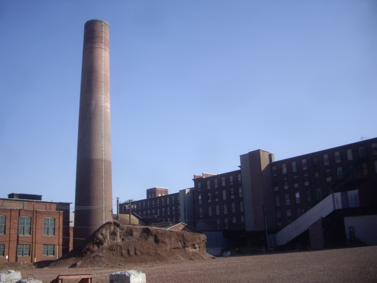
Clark Thread Company Historic District
Monument and historic site · National Register of Historic Places · 3.0 mi
Historic district in New Jersey, United States

Enclosure Historic District
Monument and historic site · National Register of Historic Places · 2.7 mi
Building in New Jersey, United States

Essex County Park Commission Administration Building
Monument and historic site · National Register of Historic Places · 3.5 mi
Building in New Jersey, United States

Forest Hill
Monument and historic site · National Register of Historic Places · 2.5 mi
Human settlement in Newark, New Jersey, United States of America

Iviswold
Monument and historic site · National Register of Historic Places · 3.2 mi
Building in New Jersey, United States
Jacob W. Van Winkle House
Monument and historic site · National Register of Historic Places · 2.1 mi
Historic house in New Jersey, United States
Jeremiah J. Yeareance House
Monument and historic site · National Register of Historic Places · 2.1 mi
Historic house in New Jersey, United States

Jewish Museum of New Jersey
Museum · National Register of Historic Places · 3.1 mi
Synagogue in Newark, New Jersey

Kingsland Manor
Monument and historic site · National Register of Historic Places · 2.9 mi
Historic house in Essex County, New Jersey

Kip Homestead
Monument and historic site · National Register of Historic Places · 3.0 mi
Building in New Jersey, United States

Mount Pleasant Cemetery
Monument and historic site · National Register of Historic Places · 2.5 mi
Cemetery in Newark, New Jersey, United States
26 more on the map.
Parks, trails and playgrounds29


Branch Brook Park
Park · National Register of Historic Places · 2.8 mi
County park of Essex County, New Jersey

InHome Golf
Golf course · 1.8 mi
InHome Golf helps design and build indoor golf simulators across The United States and Canada.
1000 Wall Street West, Lyndhurst
Mo-Fr 08:00-18:00



17 more on the map.
Restaurants and cafes66




Arlington Diner
Diner · American · 1.1 mi
1 River Road, North Arlington
54 more on the map.
History
North Arlington was originally part of an area called "New Barbadoes Neck".
Copper was mined at the Schuyler Copper Mine in present-day North Arlington during the 18th and 19th centuries. It was one of the first true copper mines in North America.
In 1755, the first steam engine in North America was assembled in North Arlington. The Newcomen steam engine was imported from England by John Schuyler to pump water out of his copper mine. He hired engineer Josiah Hornblower to assemble the machinery.
North Arlington was formed by a referendum passed on March 9, 1896, and incorporated as a borough by an act of the New Jersey Legislature on March 11, 1896, from area taken from Union Township. It was called North Arlington because it was north of the Arlington section of Kearny, which had been named from the Arlington Station on the Erie Railroad.
North Arlington, together with Lyndhurst and Rutherford, was the site of the EnCap project, an effort to remediate landfills on the 785-acre (3.18 km2) site and construct homes and golf courses on top of the cleaned up site. On May 27, 2008, the New Jersey Meadowlands Commission terminated its agreement with EnCap Golf Holdings, the company that had the contract to redevelop the site, after the company had missed targets to clean up the landfills as part of the project.
From the History section of North Arlington, New Jersey on Wikipedia, under CC BY-SA 4.0.
Where to stay2
Churches and places of worship39
Belleville Avenue Congregational Church
Church · National Register of Historic Places · 3.1 mi
Cathedral Basilica of the Sacred Heart
Church · National Register of Historic Places · 3.5 mi
House of Prayer Episcopal Church and Rectory
Church · National Register of Historic Places · 3.5 mi
Reformed Dutch Church of Second River
Church · National Register of Historic Places · 1.2 mi
St. Lucy's Church
Church · National Register of Historic Places · 3.6 mi
Bethany Lutheran Church
Church · Lutheran · 1.7 mi
262 Joralemon Street, Belleville
St. Mary & St. Mercurius Coptic Orthodox Church
Church · Orthodox · 1.4 mi
125 Academy Street, Belleville
St. Peter's Roman Catholic Church
Church · Catholic · 1.6 mi
155 William Street, Belleville
Shopping8
Gas and EV charging9
Schools, colleges and libraries65
Healthcare5
Washington Drugs Pharmacy
Clinic and pharmacy · 1.4 mi
529 Washington Avenue, Belleville
Map of North Arlington
250 places. The map loads OpenStreetMap tiles when you open it.
Climate by month
Monthly table
| Month | High | Low | Rain | Snow |
|---|---|---|---|---|
| Jan | 39°F | 25°F | 3.7 in | 8.0 in |
| Feb | 42°F | 26°F | 3.3 in | 8.4 in |
| Mar | 50°F | 33°F | 4.3 in | 4.7 in |
| Apr | 62°F | 43°F | 4.1 in | 0.7 in |
| May | 72°F | 54°F | 4.4 in | 0.0 in |
| Jun | 82°F | 63°F | 4.9 in | 0.0 in |
| Jul | 87°F | 69°F | 4.8 in | 0.0 in |
| Aug | 85°F | 67°F | 4.4 in | 0.0 in |
| Sep | 78°F | 60°F | 4.3 in | 0.0 in |
| Oct | 66°F | 48°F | 4.2 in | 0.2 in |
| Nov | 54°F | 38°F | 3.6 in | 0.3 in |
| Dec | 44°F | 30°F | 4.6 in | 5.9 in |
U.S. Climate Normals 1991-2020 for Harrison (3 mi away), NOAA NCEI.
People and cost of living
American Community Survey 5-year estimates, 2020-2024, U.S. Census Bureau. Estimates have margins of error, larger for small towns.
Disaster history
Bergen County has had 21 federal disaster declarations since 2000, most often for hurricanes.
- 2021-09-05: Remnants Of Hurricane Ida (Hurricane)
- 2021-09-02: Remnants Of Hurricane Ida (Hurricane)
- 2020-12-11: Tropical Storm Isaias (Hurricane)
- 2020-03-25: Covid-19 Pandemic (Biological)
- 2020-03-13: Covid-19 (Biological)
- 2018-06-08: Severe Winter Storm And Snowstorm (Severe Storm)
OpenFEMA disaster declarations summaries.
Getting there and nearby towns
Teterboro Airport (TEB) is the nearest airport with scheduled flights listed in OpenStreetMap, 6 miles away.
- Kearny 2 mi south, about 4 min by car
- East Rutherford 3 mi northeast, about 5 min by car
- Harrison 3 mi southwest, about 5 min by car
- Newark 5 mi southwest, about 8 min by car
- East Orange 5 mi west, about 8 min by car
- Wallington 5 mi north, about 8 min by car
- Wood-Ridge 5 mi northeast, about 8 min by car
- Clifton 6 mi north, about 9 min by car
- Jersey City 6 mi southeast, about 10 min by car
- Hoboken 6 mi southeast, about 9 min by car
Drive times are estimates from straight-line distance, not routes.
Local news
Headlines from INDB, the NEMICO news database.
Reviews, tips and questions
Loading what members have shared...
Sources and licences
- NCES EDGE (Public domain): public schools
- NOAA NCEI U.S. Climate Normals 1991-2020 (Public domain): climate by month
- OpenFEMA (Public domain): disaster declarations
- OpenStreetMap contributors (ODbL 1.0): places, airports, map data
- U.S. Census Bureau (Public domain): population, income, housing, education, commute
- Wikidata (CC0 1.0): elevation, founding date, time zone, website, landmarks and historic places
- Wikimedia Commons (see each image): photos
- Wikipedia (CC BY-SA 4.0): overview and history text
Photo credits
- Belleville Turnpike lift bridge SW cloudy jeh, Jim.henderson, CC0
- North Arlington, NJ borough hall, Jan. 2025, Mr. Matté (if there is an issue with this image, contact me using this image's Commons talk page , my Commons user talk page , or my English Wikipedia user talk page ; I'll know about it a lot faster), CC BY-SA 4.0
- North Arlington High School, NJ, Jan. 2025, Mr. Matté (if there is an issue with this image, contact me using this image's Commons talk page , my Commons user talk page , or my English Wikipedia user talk page ; I'll know about it a lot faster), CC BY-SA 4.0
- Prospect Avenue sb, North Arlington, NJ, Jan. 2025, Mr. Matté (if there is an issue with this image, contact me using this image's Commons talk page , my Commons user talk page , or my English Wikipedia user talk page ; I'll know about it a lot faster), CC BY-SA 4.0
- 2018-07-07 16 40 50 View north along New Jersey State Route 7 and County Route 507 (Belleville Turnpike) at Schuyler Avenue on the border of Kearny, Hudson County and North Arlington, Bergen County..., Famartin, CC BY-SA 4.0
- 2018-07-19 10 08 10 View south along New Jersey State Route 17 (Ridge Road) between Bogle Avenue and Bergen Avenue in North Arlington, Bergen County, New Jersey, Famartin, CC BY-SA 4.0
- 2018-07-19 10 17 40 View north along New Jersey State Route 17 (Ridge Road) just north of New Jersey State Route 7 and County Route 507 (Belleville Turnpike) in North Arlington, Bergen County, New..., Famartin, CC BY-SA 4.0
- NJ Route 7 wb at Garden Terrace, North Arlington, Jan. 2025, Mr. Matté (if there is an issue with this image, contact me using this image's Commons talk page , my Commons user talk page , or my English Wikipedia user talk page ; I'll know about it a lot faster), CC BY-SA 4.0
- 2018-07-07 16 50 07 View south along New Jersey State Route 7 and County Route 507 (Belleville Turnpike) at Ross Lane and Roosevelt Street on the border of Kearny, Hudson County and North Arlington..., Famartin, CC BY-SA 4.0
- 2018-07-19 15 02 18 View north along Bergen County Route 507 (River Road) just north of New Jersey State Route 7 (Belleville Turnpike) in North Arlington, Bergen County, New Jersey, Famartin, CC BY-SA 4.0
- Welcome to North Arlington 2023 jeh, Jim.henderson, CC BY 4.0
- Belleville Dutch Reform Ch SE cloudy jeh, Jim.henderson, CC0
- Bound Brook Park (13971717804), Hypnotica Studios Infinite from Toms River, New Jersey, USA, CC BY 2.0
- KIP HOMESTEAD, RUTHERFORD, BERGEN COUNTY, NJ, JERRYE & ROY KLOTZ M.D., CC BY-SA 4.0
- ESSEX COUNTY PARK COMMISSION ADMINISTRATION BUILDING, ESSEX COUNTY, NJ, JERRYE AND ROY KLOTZ, M.D., CC BY-SA 4.0
- Kingsland Manor, HistoricRestorationTrustofNutley, CC BY-SA 3.0
- Oakes Mansion jeh, Jim.henderson, CC0
- George Opdyke tomb, George Eisenman, Public domain
- ACKERMAN-DEWSNAP HOUSE, SADDLE RIVER, BERGEN COUNTY, NJ, JERRYE & ROY KLOTZ M.D., CC BY-SA 4.0
- Forest Hill Presby 101 Heller Pkwy cloudy jeh, Jim.henderson, CC0
- Clark-thread-co, Dmadeo, CC BY-SA 4.0
- ENCLOSURE HISTORIC DISTRICT, NUTLEY, ESSEX COUNTY NJ, JERRYE & ROY KLOTZ, M.D., CC BY-SA 4.0
- State Street School, Rajkiran Pericherla, CC BY-SA 3.0
- WILLIAM CLARK HOUSE, NEWARK, ESSEX NJ, JERRYE & ROY KLOTZ, M.D., CC BY-SA 4.0
- YereanceKettelhouse, Rhvanwinkle at English Wikipedia, CC BY-SA 3.0
- House of Prayer CoE Newark sunny jeh, Jim.henderson, CC0
- Ahavas Sholom Newark Front, Peter Greenberg, CC BY-SA 4.0
- Lucy RCC Newark jeh, Jim.henderson, CC0
- YEREANCE-BERRY HOUSE, RUTHERFORD, BERGEN COUNTY, JERRYE & ROY KLOTZ, M.D., CC BY-SA 4.0
- RutherfordNJ WomensClub2, Magicpiano, CC BY-SA 4.0
- Rutherford Station - January 2015, Adam Moss, CC BY-SA 2.0
- Americas War Newark NJ 4, Smallbones, CC0
- 29 Old Rd Sydenham house back jeh, Jim.henderson, CC0
- VREELAND HOMESTEAD, NUTLEY, ESSEX COUNTY, NJ, JERRYE & ROY KLOTZ, M.D., CC BY-SA 4.0
- Sacred Heart fr hill center jeh, Jim.henderson, CC0
- RIVER ROAD SCHOOL, LYNDHURST, BERGEN COUNTY, NJ, JERRYE & ROY KLOTZ, M.D., CC BY-SA 4.0
- WILLIAM CARLOS WILLIAMS HOUSE, RUTHERFORD, BERGEN COUNTY, NJ, JERRYE & ROY KLOTZ M.D., CC BY-SA 4.0
- PROTESTANT FOSTER HOME, NEWARK, ESSEX COUNTY, NJ, JERRYE & ROY KLOTZ, M.D., CC BY-SA 4.0
- Broad St Sta Newark tower jeh, Jim.henderson, Public domain
- BELLEVILLE AVENUE CONGREGATIONAL CHURCH, NEWARK, ESSEX COUNTY, NJ, JERRYE & ROY KLOTZ, M.D., CC BY-SA 4.0


Page built October 30, 2026. Spotted a mistake? Tell us or suggest a place.