


North Charleston, South Carolina
North Charleston is a city of 119,913 people in Berkeley County, South Carolina, founded in 1972.
Why visit North Charleston
Townapedia lists 30 museums and landmarks, 33 parks and trails, 237 places to eat, 49 places to stay and 6 attractions in and around town.
Highlights include Charleston Southern University, Don N. Holt Bridge, Ashley River Historic District and Charles Towne Landing.
July is the warmest month, with average highs of 91°F; January lows average 39°F.
Weather in North Charleston
Forecast from the National Weather Service. Full forecast
About North Charleston
North Charleston is a city in Berkeley, Charleston, and Dorchester counties in the U.S. state of South Carolina. As of the 2020 census, North Charleston had a population of 114,852, making it the third-most populous city in the state, and the 248th-most populous city in the United States. North Charleston is a principal city within the Charleston-North Charleston, SC Metropolitan Statistical Area, which had an estimated population of 849,417 in 2023.
From the Wikipedia article North Charleston, South Carolina (this version), under CC BY-SA 4.0.
Things to do6

Charleston Southern University
School · 4.4 mi
Baptist university in South Carolina, U.S.

Don N. Holt Bridge
Bridge · 6.2 mi
Bridge in North Charleston, Charleston
General William C. Westmoreland Bridge
Bridge · 6.2 mi
Bridge in United States of America


Museums and landmarks30

Ashley River Historic District
Monument and historic site · National Register of Historic Places · 3.3 mi
United States historic place

Charles Towne Landing
Monument and historic site · National Register of Historic Places · 8.8 mi
Park in South Carolina, United States of America, United States of America

Charleston Navy Yard Officers' Quarters Historic District
Monument and historic site · National Register of Historic Places · 6.5 mi
Historic house in South Carolina, United States

Dorchester
Monument and historic site · National Register of Historic Places · 6.4 mi
Colonial-era settlement, abandoned in 1751.
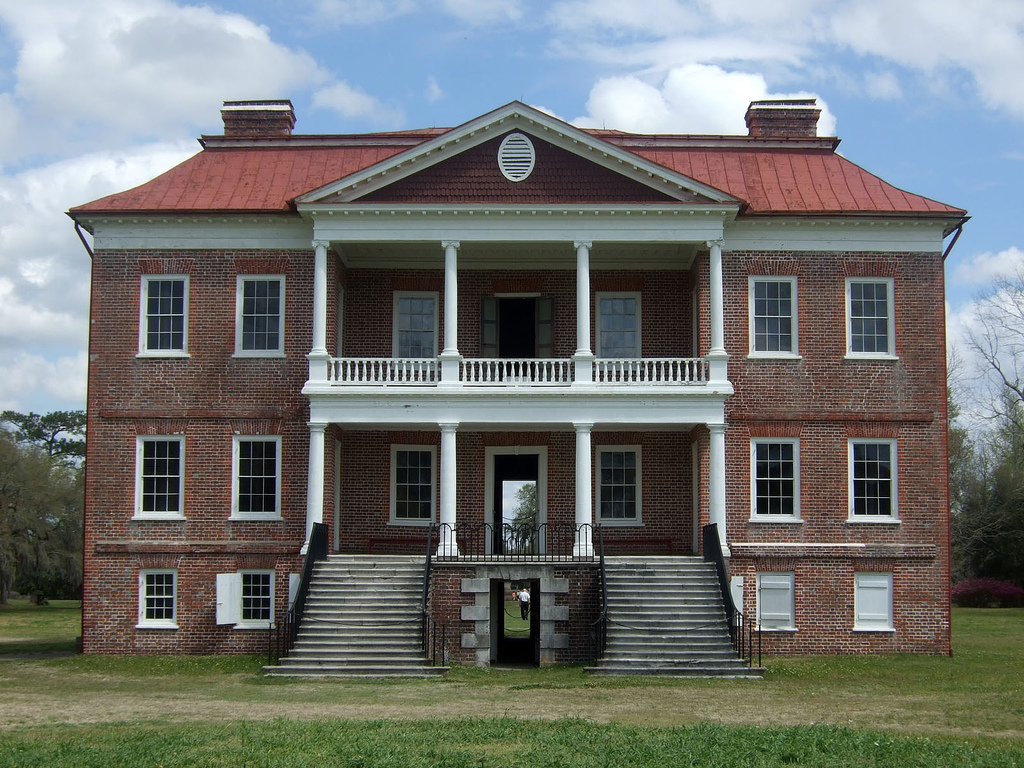
Drayton Hall
Monument and historic site · National Register of Historic Places · 3.3 mi
Human settlement in South Carolina, United States of America
H. L. Hunley
Monument and historic site · National Register of Historic Places · 7.5 mi
Submarine of the Confederate States of America (1863/1864)

Middleton Place
Monument and historic site · National Register of Historic Places · 4.3 mi
Historic plantation in Dorchester County, South Carolina, U.S.A.


Old White Meeting House Ruins and Cemetery
Monument and historic site · National Register of Historic Places · 8.2 mi
Archaeological site in South Carolina, United States
Otranto Plantation
Monument and historic site · National Register of Historic Places · 3.8 mi
Historic plantation house located in Hanahan, South Carolina, United States

South Carolina Highway 61
Monument and historic site · National Register of Historic Places · 4.3 mi
Highway in South Carolina
Battery Wilkes
Monument and historic site · National Register of Historic Places · 8.5 mi
18 more on the map.
Parks, trails and playgrounds33


Magnolia Plantation and Gardens (Charleston, South Carolina)
Park · National Register of Historic Places · 3.0 mi
Human settlement in South Carolina, United States of America

Bees Landing Park
Park · 6.2 mi
Park in South Carolina, United States of America
West Ashley Park
Park · 6.8 mi
Park in South Carolina, United States of America

The Amenity Center playground
Park · 3.3 mi
1600 Crossbill Trail, Hanahan
06:00-21:00
21 more on the map.
Restaurants and cafes237



Olive Garden
Restaurant · Italian · 2.3 mi
2156 Northwoods Boulevard
Mo-Su 11:00-22:00
225 more on the map.
Where to stay49
Comfort Suites North Charleston - Ashley Phosphate
Motel and hotel · 1.5 mi
2450 Prospect Drive, North Charleston
Courtyard North Charleston Airport/Coliseum
Motel and hotel · 4.3 mi
2415 Mall Drive, North Charleston
Residence Inn Charleston North/Ashley Phosphate
Motel and hotel · 1.5 mi
7457 Northside Drive, North Charleston
Sleep Inn North Charleston Ashley Phosphate
Motel and hotel · 1.5 mi
7435 Northside Drive, North Charleston
Churches and places of worship61
St. Andrews Episcopal Church
Church · National Register of Historic Places · 5.5 mi
St. James Church
Church · National Register of Historic Places · 4.5 mi
Kingdom Hall ofJehovah’s Witnesses
Church · Jehovahs Witness · 2.9 mi
4600 Appian Way, North Charleston
Christ Community Lutheran Church
Church · Lutheran · 2.3 mi
8315 Dorchester Road, North Charleston
Coastal Shores Baptist Church
Church · Baptist · 2.3 mi
8310 Dorchester Road, North Charleston
Iglesia De Jesucristo Sendred De Luz
Church · Evangelical · 3.5 mi
2068 Harley Street, North Charleston
Adams African Methodist Episcopal Church
Church · African Methodist Episcopal · 4.2 mi
Shopping65
Gas and EV charging39
Schools, colleges and libraries75
Windsor Hill Arts Infused Elementary School
School · 2.5 mi
8600 William Moultrie Drive, North Charleston
Academic Magnet High
School · 4.4 mi
5109-A West Enterprise Street, North Charleston
Allegro Charter School of Music
School · 5.3 mi
2731 Gordon Street, North Charleston
Charleston School of The Arts
School · 4.4 mi
5109-B West Enterprise Street, North Charleston
Healthcare33
MUSC Health Primary Care - North Charleston
Clinic and pharmacy · 4.1 mi
8992 University Boulevard, North Charleston
Passport Health North Charleston Travel Clinic
Clinic and pharmacy · 2.0 mi
2154 North Center Street, North Charleston
R. Keith Summey Medical Pavilion
Clinic and pharmacy · 4.0 mi
2250 Mall Drive, North Charleston
Map of North Charleston
250 places. The map loads OpenStreetMap tiles when you open it.
Climate by month
Monthly table
| Month | High | Low | Rain | Snow |
|---|---|---|---|---|
| Jan | 60°F | 39°F | 3.4 in | 0.2 in |
| Feb | 64°F | 42°F | 3.0 in | 0.1 in |
| Mar | 70°F | 47°F | 3.4 in | 0.0 in |
| Apr | 77°F | 54°F | 3.3 in | 0.0 in |
| May | 84°F | 63°F | 3.3 in | 0.0 in |
| Jun | 88°F | 70°F | 6.2 in | 0.0 in |
| Jul | 91°F | 74°F | 6.6 in | 0.0 in |
| Aug | 90°F | 73°F | 7.0 in | 0.0 in |
| Sep | 85°F | 68°F | 6.0 in | 0.0 in |
| Oct | 78°F | 58°F | 4.3 in | 0.0 in |
| Nov | 69°F | 47°F | 2.7 in | 0.0 in |
| Dec | 63°F | 42°F | 3.4 in | 0.0 in |
U.S. Climate Normals 1991-2020 for Charleston Intl Ap Gsn 72208 (2 mi away), NOAA NCEI.
People and cost of living
American Community Survey 5-year estimates, 2020-2024, U.S. Census Bureau. Estimates have margins of error, larger for small towns.
Disaster history
Berkeley County has had 27 federal disaster declarations since 2000, most often for hurricanes.
- 2026-01-23: Severe Winter Storm (Winter Storm)
- 2024-09-29: Hurricane Helene (Hurricane)
- 2024-09-29: Tropical Storm Debby (Tropical Storm)
- 2024-09-26: Hurricane Helene (Tropical Storm)
- 2024-08-05: Hurricane Debby (Tropical Storm)
- 2023-08-31: Hurricane Idalia (Hurricane)
OpenFEMA disaster declarations summaries.
Getting there and nearby towns
Charleston International Airport (CHS) is the nearest airport with scheduled flights listed in OpenStreetMap, 2 miles away.
- Hanahan 4 mi east, about 6 min by car
- Goose Creek 6 mi northeast, about 10 min by car
- Ladson 7 mi north, about 11 min by car
- Charleston 8 mi southeast, about 13 min by car
- Lincolnville 8 mi northwest, about 13 min by car
- Summerville 9 mi northwest, about 14 min by car
- Sangaree 9 mi northwest, about 14 min by car
- Ravenel 13 mi southwest, about 20 min by car
- Mount Pleasant 14 mi southeast, about 22 min by car
- James Island 15 mi southeast, about 23 min by car
Drive times are estimates from straight-line distance, not routes.
Local news
Headlines from INDB, the NEMICO news database.
Reviews, tips and questions
Loading what members have shared...
Sources and licences
- NCES EDGE (Public domain): public schools
- NOAA NCEI U.S. Climate Normals 1991-2020 (Public domain): climate by month
- OpenFEMA (Public domain): disaster declarations
- OpenStreetMap contributors (ODbL 1.0): places, airports, map data
- U.S. Census Bureau (Public domain): population, income, housing, education, commute
- Wikidata (CC0 1.0): elevation, founding date, time zone, website, landmarks and historic places
- Wikimedia Commons (see each image): photos
- Wikipedia (CC BY-SA 4.0): overview and history text
Photo credits
- City Hall goes pink for Breast Cancer Awareness (8115852857), North Charleston from North Charleston, SC, United States, CC BY-SA 2.0
- Race and ethnicity 2020 North Charleston, SC, CensusDots, CC BY-SA 4.0
- National Night Out in North Charleston (9499950673), North Charleston from North Charleston, SC, United States, CC BY-SA 2.0
- National Night Out in North Charleston (9502744934), North Charleston from North Charleston, SC, United States, CC BY-SA 2.0
- National Night Out in North Charleston (9499943017), North Charleston from North Charleston, SC, United States, CC BY-SA 2.0
- National Night Out in North Charleston (9499948563), North Charleston from North Charleston, SC, United States, CC BY-SA 2.0
- National Night Out in North Charleston (9502748394), North Charleston from North Charleston, SC, United States, CC BY-SA 2.0
- National Night Out in North Charleston (9502747186), North Charleston from North Charleston, SC, United States, CC BY-SA 2.0
- National Night Out in North Charleston (9499945765), North Charleston from North Charleston, SC, United States, CC BY-SA 2.0
- National Night Out in North Charleston (9502742630), North Charleston from North Charleston, SC, United States, CC BY-SA 2.0
- National Night Out in North Charleston (9502745522), North Charleston from North Charleston, SC, United States, CC BY-SA 2.0
- National Night Out in North Charleston (9502743948), North Charleston from North Charleston, SC, United States, CC BY-SA 2.0
- National Night Out in North Charleston (9499948273), North Charleston from North Charleston, SC, United States, CC BY-SA 2.0
- National Night Out in North Charleston (9502743196), North Charleston from North Charleston, SC, United States, CC BY-SA 2.0
- National Night Out in North Charleston (9502743398), North Charleston from North Charleston, SC, United States, CC BY-SA 2.0
- National Night Out in North Charleston (9502745302), North Charleston from North Charleston, SC, United States, CC BY-SA 2.0
- National Night Out in North Charleston (9499948157), North Charleston from North Charleston, SC, United States, CC BY-SA 2.0
- National Night Out in North Charleston (9499946299), North Charleston from North Charleston, SC, United States, CC BY-SA 2.0
- National Night Out in North Charleston (9499946547), North Charleston from North Charleston, SC, United States, CC BY-SA 2.0
- National Night Out in North Charleston (9502743692), North Charleston from North Charleston, SC, United States, CC BY-SA 2.0
- National Night Out in North Charleston (9502747284), North Charleston from North Charleston, SC, United States, CC BY-SA 2.0
- National Night Out in North Charleston (9502748200), North Charleston from North Charleston, SC, United States, CC BY-SA 2.0
- Cabin at Charles Towne Landing, South Carolina, August 2016, The ed17, CC BY-SA 4.0
- Ashley River Road 1.8 mi N of Bees Ferry Rd, Ammodramus, CC0
- Middleton-place-sc1, Brian Stansberry, CC BY 3.0
- Ashley River Road 2.9 mi N of Bees Ferry Rd 2, Ammodramus, CC0
- Magnolia Plantation and Gardens (52155182156), Nick Amoscato, CC BY 2.0
- 120925e 0507 Old White Meeting House Ruins and Cemetery Peer Thru Trees At Headstones, Lazyksaw, CC BY-SA 3.0
- St Andrews Parish Church, Doug Kerr, CC BY-SA 2.0
- Drayton Hall 2007, Goingstuckey, CC BY-SA 3.0
- Admiral's House - front, ProfReader, CC BY-SA 4.0
- South Carolina National Guard - 1, The National Guard, CC BY 2.0
- South Carolina National Guard - 53909283177, The National Guard, CC BY 2.0
- Senator Tim Scott at RB Stall High School (8498732264), North Charleston from North Charleston, SC, United States, CC BY-SA 2.0
- Senator Tim Scott at RB Stall High School (8498733338), North Charleston from North Charleston, SC, United States, CC BY-SA 2.0
- Senator Tim Scott at RB Stall High School (8497628531), North Charleston from North Charleston, SC, United States, CC BY-SA 2.0
- Color Guard at RB Stall High School (8497630255), North Charleston from North Charleston, SC, United States, CC BY-SA 2.0
- Senator Tim Scott at RB Stall High School (8498732264) (cropped), North Charleston from North Charleston, SC, United States, CC BY-SA 2.0
- Senator Tim Scott at RB Stall High School (8498732788), North Charleston from North Charleston, SC, United States, CC BY-SA 2.0
- Senator Tim Scott at RB Stall High School (8497629985), North Charleston from North Charleston, SC, United States, CC BY-SA 2.0


Page built October 30, 2026. Spotted a mistake? Tell us or suggest a place.