


North Falmouth, Massachusetts
North Falmouth is a community of 2,838 people in Barnstable County, Massachusetts.
Why visit North Falmouth
Townapedia lists 6 museums and landmarks, 28 parks and trails, 10 places to eat, 1 place to stay and 3 attractions in and around town.
Highlights include Cleveland East Ledge Light, New Silver Beach, Cataumet Schoolhouse and Crowell-Bourne Farm.
July is the warmest month, with average highs of 79°F; January lows average 25°F.
Weather in North Falmouth
Forecast from the National Weather Service. Full forecast
About North Falmouth
North Falmouth is a census-designated place (CDP) in the town of Falmouth in Barnstable County, Massachusetts, United States. As of the 2020 census, North Falmouth had a population of 3,293.
From the Wikipedia article North Falmouth, Massachusetts (this version), under CC BY-SA 4.0.
Things to do3

Cleveland East Ledge Light
Lighthouse · National Register of Historic Places · 3.4 mi
Lighthouse in Massachusetts, United States

New Silver Beach
Beach · 0.5 mi
Village in Massachusetts, United States

Museums and landmarks6

Cataumet Schoolhouse
Monument and historic site · National Register of Historic Places · 2.3 mi
Historic school building at 1200 County Road in Bourne, Massachusetts

Crowell-Bourne Farm
Monument and historic site · National Register of Historic Places · 1.7 mi
Historic house in Massachusetts, United States

Elnathan Nye House
Monument and historic site · National Register of Historic Places · 0.7 mi
Historic house in Massachusetts, United States

North Falmouth Village Historic District
Monument and historic site · National Register of Historic Places · 0.8 mi
Historic district in Massachusetts, United States

West Falmouth Village Historic District
Monument and historic site · National Register of Historic Places · 2.8 mi
Historic district in Massachusetts, United States
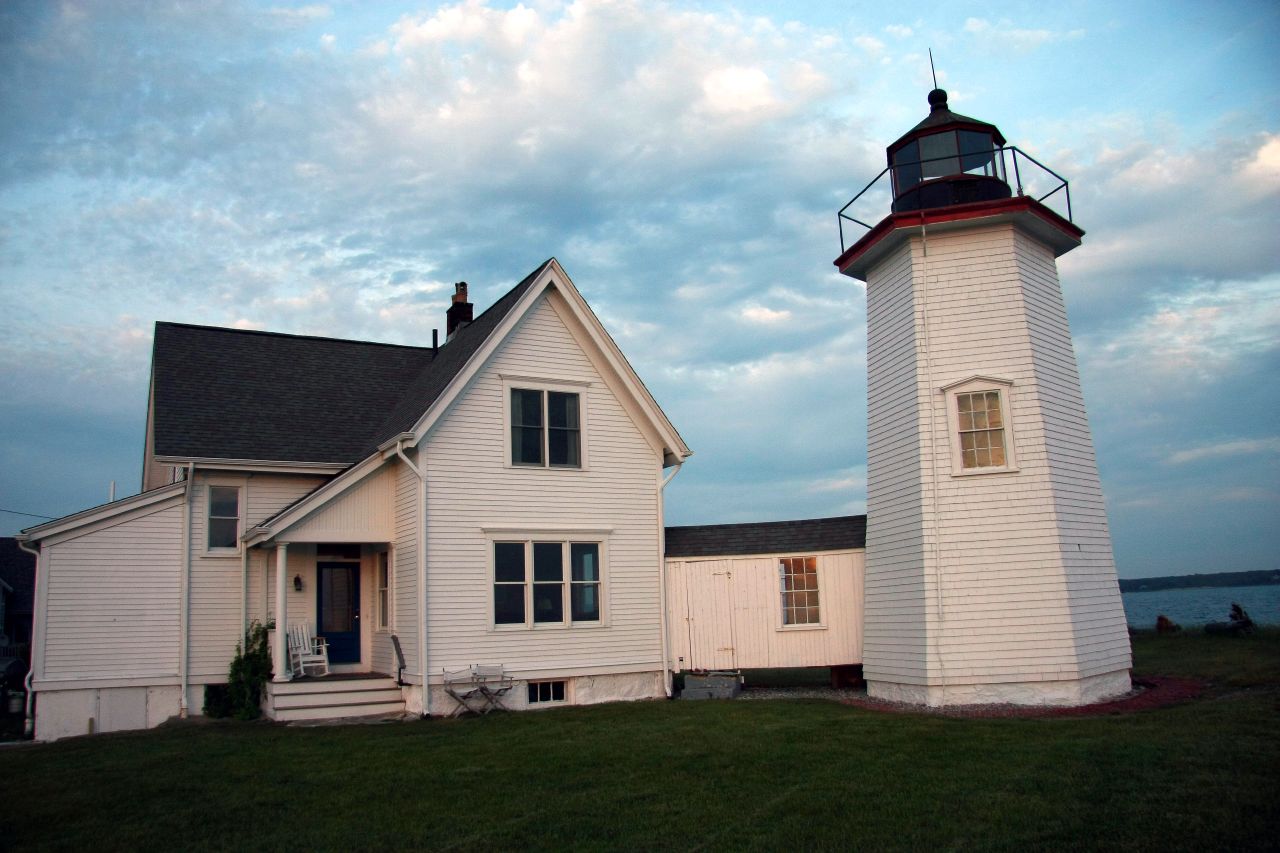


Wing's Neck Light
Lighthouse · National Register of Historic Places · 3.2 mi
Lighthouse in Massachusetts, United States
Parks, trails and playgrounds28




16 more on the map.
Restaurants and cafes10

Silver Beach Pizza & Seafood
Restaurant · Pizza · 1.0 mi
557 North Falmouth Highway, North Falmouth



Where to stay1
Shopping2
Schools, colleges and libraries8
North Falmouth Elementary School Library
Library · 0.6 mi
62 Old Main Road, Falmouth
Map of North Falmouth
58 places. The map loads OpenStreetMap tiles when you open it.
Climate by month
Monthly table
| Month | High | Low | Rain |
|---|---|---|---|
| Jan | 39°F | 25°F | 4.3 in |
| Feb | 40°F | 25°F | 3.9 in |
| Mar | 45°F | 30°F | 5.1 in |
| Apr | 55°F | 39°F | 4.2 in |
| May | 64°F | 48°F | 3.6 in |
| Jun | 72°F | 58°F | 3.8 in |
| Jul | 79°F | 64°F | 2.9 in |
| Aug | 79°F | 64°F | 3.6 in |
| Sep | 73°F | 59°F | 4.1 in |
| Oct | 62°F | 49°F | 4.8 in |
| Nov | 53°F | 40°F | 4.3 in |
| Dec | 45°F | 32°F | 5.0 in |
U.S. Climate Normals 1991-2020 for Woods Hole Golf Club (8 mi away), rain and snow from Falmouth 3.1 Nnw, NOAA NCEI.
People and cost of living
American Community Survey 5-year estimates, 2020-2024, U.S. Census Bureau. Estimates have margins of error, larger for small towns.
Disaster history
Barnstable County has had 16 federal disaster declarations since 2000, most often for hurricanes.
- 2023-09-15: Hurricane Lee (Hurricane)
- 2020-03-27: Covid-19 Pandemic (Biological)
- 2020-03-13: Covid-19 (Biological)
- 2018-06-25: Severe Winter Storm And Flooding (Severe Storm)
- 2015-04-13: Severe Winter Storm, Snowstorm, And Flooding (Severe Storm)
- 2013-04-19: Severe Winter Storm, Snowstorm, And Flooding (Severe Storm)
OpenFEMA disaster declarations summaries.
Getting there and nearby towns
Cape Cod Coast Guard Air Station (FMH) is the nearest airport with scheduled flights listed in OpenStreetMap, 6 miles away.
- Monument Beach 6 mi north, about 9 min by car
- Bourne 6 mi north, about 10 min by car
- Buzzards Bay 8 mi north, about 12 min by car
- Marion Center 8 mi northwest, about 12 min by car
- Mattapoisett Center 9 mi west, about 14 min by car
- Barnstable Town 14 mi east, about 23 min by car
- New Bedford 16 mi west, about 26 min by car
- South Yarmouth 22 mi east, about 36 min by car
- North Lakeville 22 mi northwest, about 36 min by car
- Fall River 24 mi west, about 39 min by car
Drive times are estimates from straight-line distance, not routes.
Local news
Headlines from INDB, the NEMICO news database.
Reviews, tips and questions
Loading what members have shared...
Sources and licences
- NCES EDGE (Public domain): public schools
- NOAA NCEI U.S. Climate Normals 1991-2020 (Public domain): climate by month
- OpenFEMA (Public domain): disaster declarations
- OpenStreetMap contributors (ODbL 1.0): places, airports, map data
- U.S. Census Bureau (Public domain): population, income, housing, education, commute
- Wikidata (CC0 1.0): elevation, founding date, time zone, website, landmarks and historic places
- Wikimedia Commons (see each image): photos
- Wikipedia (CC BY-SA 4.0): overview and history text
Photo credits
- Congregational Church, North Falmouth MA, John Phelan, CC BY-SA 3.0
- North Falmouth station 1908 postcard, Unknown author Unknown author, Public domain
- St Francis of Assisi at Rest, Old Silver Beach, North Falmouth, Barnstable County, Massachusetts, Jim McIntosh, CC BY 2.0
- West Falmouth Library and Quaker Carriage Sheds, West Falmouth, MA, WestFalmouth, CC BY-SA 3.0
- Cataumet Schoolhouse, 1894, Cataumet MA, John Phelan, CC BY-SA 3.0
- Elnathan Nye House, North Falmouth MA, John Phelan, CC BY-SA 3.0
- Capt. James Nye House, North Falmouth MA, John Phelan, CC BY-SA 3.0
- Wing's Neck Light - Bourne MA, Bruce Tuten from Savannah, Georgia, United States, CC BY 2.0
- Birds Roosting Power Lines (Unsplash), Danielle MacInnes dsmacinnes, CC0
- Strobilomyces strobilaceus 95278082, Katerina, CC BY 4.0
- Strobilomyces strobilaceus 95278061, Katerina, CC BY 4.0
- Strobilomyces strobilaceus 95278116, Katerina, CC BY 4.0
- Strobilomyces strobilaceus 95278032, Katerina, CC BY 4.0
- Strobilomyces strobilaceus 95278015, Katerina, CC BY 4.0
- Strobilomyces strobilaceus 95278099, Katerina, CC BY 4.0
- Neolecta irregularis 94279, Nathan Wilson, CC BY 4.0
- Rhyssa lineolata, Jake McCumber, CC BY-SA 4.0
- Lycogala epidendrum 83462320, Jake McCumber, CC BY-SA 4.0
- Olethreutes trepidulum, Jake McCumber, CC BY 4.0
- Conura coxalis, Jake McCumber, CC BY 4.0
- Acleris maculidorsana, Jake McCumber, CC BY-SA 4.0
- Plutella xylostella 137280235, Jake McCumber, CC BY-SA 4.0
- Aphis viburniphila 282136041, Jake McCumber, CC BY-SA 4.0
- Papilio troilus - Raupe 156909222, Jake McCumber, CC BY-SA 4.0
- Abagrotis alternata 96963615, Jake McCumber, CC BY-SA 4.0
- Aphis viburniphila 282136162, Jake McCumber, CC BY-SA 4.0
- Dichelonyx albicollis 289757951, Jake McCumber, CC BY-SA 4.0
- Pseudacris crucifer 163199675, Jake McCumber, CC BY-SA 4.0
- Abagrotis alternata 96963600, Jake McCumber, CC BY-SA 4.0
- Dichelonyx albicollis 134451579, Jake McCumber, CC BY-SA 4.0
- Shining Sea Bikeway War Dog Memorial, Kenneth C. Zirkel, CC BY-SA 4.0
- Falmouth Massachusetts public library, Kenneth C. Zirkel, CC BY-SA 4.0
- Squilla empusa 105830484, Jake McCumber, CC BY-SA 4.0
- Squilla empusa 105830515, Jake McCumber, CC BY-SA 4.0
- Squilla empusa 105830594, Jake McCumber, CC BY-SA 4.0
- Squilla empusa 105830522, Jake McCumber, CC BY-SA 4.0
- Squilla empusa 105830620, Jake McCumber, CC BY-SA 4.0
- Squilla empusa 105830525, Jake McCumber, CC BY-SA 4.0
- Baxendale Estate and mausoleum, Axeledits, CC BY 4.0
- Crassostrea virginica 518496686, Andy Deans, CC BY 4.0


Page built October 30, 2026. Spotted a mistake? Tell us or suggest a place.