


Norwalk, California
Norwalk is a city of 99,789 people in Los Angeles County, California, founded in 1957.
Why visit Norwalk
Townapedia lists 13 museums and landmarks, 47 parks and trails, 144 places to eat, 12 places to stay and 8 attractions in and around town.
Highlights include Regency Norwalk 8, AMC Norwalk 20, Casa de Parley Johnson and Clarke Estate.
August is the warmest month, with average highs of 87°F; December lows average 46°F.
Weather in Norwalk
Forecast from the National Weather Service. Full forecast
About Norwalk
Norwalk is a city in Los Angeles County, California, United States. The population was 102,773 at the 2020 census.
From the Wikipedia article Norwalk, California (this version), under CC BY-SA 4.0.
Things to do8


Biola University
School · 3.8 mi
Christian university near Los Angeles
Edwards Cerritos Stadium 10
Cinema and theater · 2.9 mi
12761 Towne Center Drive, Cerritos
Museums and landmarks13
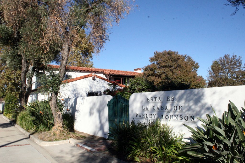
Casa de Parley Johnson
Monument and historic site · National Register of Historic Places · 4.4 mi
Historic house in Downey, California

Clarke Estate
Monument and historic site · National Register of Historic Places · 2.5 mi
Mansion in Santa Fe Springs, California

Darius David Johnston House
Monument and historic site · National Register of Historic Places · 1.1 mi
Historic house and museum in Norwalk, California

Oldest McDonald's restaurant
Museum · National Register of Historic Places · 3.4 mi
United States historic places


Orin Jordan House
Monument and historic site · National Register of Historic Places · 4.7 mi
Whittier, California, NRHP-listed
Hathaway Ranch Museum
Museum · 1.9 mi
History museum in Santa Fe Springs, California
11901 Florence Avenue, Santa Fe Springs
Columbia Memorial Space Center
Museum · 3.0 mi
Science Museum in Downey, California
Hargitt House Museum
Museum · 1.1 mi
12426 Mapledale Street, Norwalk

Clarke-Gill Estate
Monument and historic site · 2.5 mi
10211 Pioneer Boulevard, Santa Fe Springs
1 more on the map.
Parks, trails and playgrounds47

Don Knabe Regional Park
Park · 4.2 mi
Urban park in Cerritos, California

35 more on the map.
Restaurants and cafes144


Culinary Arts Cafe
Restaurant · American, Soup, Salad, Sandwich, Meat, Fish · 1.6 mi
11110 Alondra Boulevard, Norwalk
Mo-Th 11:00-13:00
Dimassi's Mediterranean Buffet
Restaurant · Mediterranean · 2.9 mi
12727 Towne Center Drive
Su-Th 11:00-21:00; Fr-Sa 11:00-22:00
Kalaveras
Restaurant · Mexican · 2.9 mi
16530 Bellflower Boulevard
Mo-Th 10:00-24:00; Fr-Sa 10:00-01:00; Su 10:00-22:00

Starbucks
Cafe · Coffee Shop · 0.4 mi
14322 Pioneer Boulevard, Norwalk
Mo-Th 05:30-22:30; Fr 05:30-23:30; Sa 05:30-00:00; Su 06:30-22:30
Starbucks
Cafe · Coffee Shop · 1.7 mi
15925 Studebaker Road, Cerritos
Mo-Sa 04:30-23:00; Su 05:30-22:00
Starbucks
Cafe · Coffee Shop · 2.9 mi
12751 Towne Center Drive, Cerritos
Mo-Fr 05:00-21:00; Sa 05:30-21:30; Su 05:30-21:00
Taibat Restaurant 泰巴特清真美食
Restaurant · Asian · 2.4 mi
11740 Artesia Boulevard
Fr-Su 11:00-21:30; Mo-Tu, Th 11:00-21:00; We off
Awake Coffee
Cafe · Coffee Shop, Tea, Ice Cream · 1.9 mi
12808 Woodruff Avenue, Downey
Mo-Su 07:00-19:00
132 more on the map.
History
The area known as "Norwalk" was first home to the Shoshonean Native American tribe. They survived primarily on honey, an array of berries, acorns, sage, squirrels, rabbits and birds. Their huts were part of the Sejat Indian village.
In the late 1760s, settlers and missions flourished under Spanish rule with the famous El Camino Real trail traversing the area. Manuel Nieto, a Spanish soldier, received a Spanish land grant (Rancho Los Nietos) in 1784 that included Norwalk.
After the Mexican–American War in 1848, the Rancho and mining days ended. Portions of the land were subdivided and made available for sale when California was admitted into the union of the United States. Word of this land development reached the Sproul Brothers in Oregon. They recalled the fertile land and huge sycamore trees they saw during an earlier visit to the Southern California area. In 1869, Atwood Sproul, on behalf of his brother, Gilbert, purchased 463 acres (1.87 km2) of land at $11 an acre ($2,700/km2) in an area known as Corazón de los Valles, or "Heart of the Valleys".
From the History section of Norwalk, California on Wikipedia, under CC BY-SA 4.0.
Where to stay12
DoubleTree by Hilton Hotel Los Angeles - Norwalk
Motel and hotel · 0.8 mi
13111 Sycamore Drive, Norwalk
Days Inn & Suites by Wyndham Artesia
Motel and hotel · 2.5 mi
17510 Pioneer Boulevard, Artesia
Churches and places of worship62
The Church of Jesus Christ of Latter-day Saints
Church · Latter-Day Saints · 1.9 mi
16115 Studebaker Road, Cerritos
Bellflower First United Methodist Church
Church · United Methodist · 2.5 mi
14525 Bellflower Boulevard, Bellflower
Shopping25
Gas and EV charging19
Schools, colleges and libraries117
Healthcare16
DaVita Downey Landing Dialysis Center
Clinic and pharmacy · 2.9 mi
11611 Bellflower Boulevard, Downey
Kaiser Permanente Bellflower Medical Offices
Clinic and pharmacy · 2.8 mi
9400 East Rosecrans Avenue, Bellflower
Kaiser Permanente Imperial Satellite Offices
Clinic and pharmacy · 2.6 mi
12200 Bellflower Boulevard, Downey
PIH Urgent Care Center
Clinic and pharmacy · 1.4 mi
12400 Bloomfield Avenue, Santa Fe Springs
Map of Norwalk
250 places. The map loads OpenStreetMap tiles when you open it.
Climate by month
Monthly table
| Month | High | Low | Rain |
|---|---|---|---|
| Jan | 69°F | 46°F | 2.9 in |
| Feb | 69°F | 48°F | 3.0 in |
| Mar | 71°F | 52°F | 1.7 in |
| Apr | 74°F | 54°F | 0.6 in |
| May | 76°F | 58°F | 0.3 in |
| Jun | 79°F | 63°F | 0.1 in |
| Jul | 84°F | 66°F | 0.0 in |
| Aug | 87°F | 66°F | 0.0 in |
| Sep | 85°F | 65°F | 0.1 in |
| Oct | 80°F | 58°F | 0.5 in |
| Nov | 74°F | 51°F | 0.7 in |
| Dec | 68°F | 46°F | 1.9 in |
U.S. Climate Normals 1991-2020 for Fullerton Muni Ap (6 mi away), NOAA NCEI.
People and cost of living
American Community Survey 5-year estimates, 2020-2024, U.S. Census Bureau. Estimates have margins of error, larger for small towns.
Disaster history
Los Angeles County has had 67 federal disaster declarations since 2000, most often for fires.
- 2025-08-08: Canyon Fire (Fire)
- 2025-01-08: Wildfires And Straight-Line Winds (Fire)
- 2025-01-08: Eaton Fire (Fire)
- 2025-01-08: Hurst Fire (Fire)
- 2025-01-07: Palisades Fire (Fire)
- 2024-12-10: Franklin Fire (Fire)
OpenFEMA disaster declarations summaries.
Getting there and nearby towns
Fullerton Municipal Airport (FUL) is the nearest airport with scheduled flights listed in OpenStreetMap, 6 miles away.
- Santa Fe Springs 2 mi northeast, about 3 min by car
- Bellflower 3 mi southwest, about 5 min by car
- Cerritos 3 mi south, about 5 min by car
- Artesia 3 mi south, about 4 min by car
- Downey 3 mi northwest, about 6 min by car
- South Whittier 3 mi northeast, about 6 min by car
- La Mirada 4 mi east, about 7 min by car
- Lakewood 5 mi southwest, about 8 min by car
- Paramount 5 mi west, about 8 min by car
- West Whittier-Los Nietos 5 mi north, about 8 min by car
Drive times are estimates from straight-line distance, not routes.
Local news
Headlines from INDB, the NEMICO news database.
Reviews, tips and questions
Loading what members have shared...
Sources and licences
- NCES EDGE (Public domain): public schools
- NOAA NCEI U.S. Climate Normals 1991-2020 (Public domain): climate by month
- OpenFEMA (Public domain): disaster declarations
- OpenStreetMap contributors (ODbL 1.0): places, airports, map data
- U.S. Census Bureau (Public domain): population, income, housing, education, commute
- Wikidata (CC0 1.0): elevation, founding date, time zone, website, landmarks and historic places
- Wikimedia Commons (see each image): photos
- Wikipedia (CC BY-SA 4.0): overview and history text
Photo credits
- Vista Verde Park, Norwalk CA, Northwalker, CC0
- Wienerschnitzel Hot Dog Restaurant in Norwalk, California, Northwalker, CC0
- Norwalk Park Panorama, Norwalk, California, Northwalker, CC0
- Los Angeles county Superior Court Norwalk California, Northwalker, CC0
- Norwalk City Hall, Norwalk, CA, Northwalker, CC0
- Norwalk, CA, USA - panoramio, peter boy12qq12, CC BY 3.0
- Sara Mendez Park Pavilion, Norwalk, California, Northwalker, CC0
- Sara Mendez Park path, Norwalk, California, Northwalker, CC0
- Sara Mendez Park Entrance, Norwalk, California, Northwalker, CC0
- Norwalk Public Library, Northwalker, CC0
- Norwalk, CA, USA - panoramio (1), peter boy12qq12, CC BY 3.0
- Norwalk, CA, USA - panoramio (2), peter boy12qq12, CC BY 3.0
- Norwalk, CA, USA - panoramio (3), peter boy12qq12, CC BY 3.0
- LA Metro Norwalk station platform, November 2023, OrdinaryScarlett, CC0
- Holifield park view, Norwalk, California, Northwalker, CC0
- Holifield park plaque, Norwalk, California, Northwalker, CC0
- Holifield park playground, Norwalk, California, Northwalker, CC0
- Holifield park view towards southeast, Norwalk, California, Northwalker, CC0
- Church's Chicken, Norwalk California, Northwalker, CC0
- Metropolitan State Hospital, Psychiatric, Norwalk California, Northwalker, CC0
- John Zimmerman Park Panorama, Norwalk, CA,, Northwalker, CC0
- John Zimmerman Park, softball, Norwalk, CA, at Sunset, Northwalker, CC0
- John Zimmerman Park Panorama, Norwalk, CA, Another View, Northwalker, CC0
- Clarke Estate SF Springs CA from Front, Northwalker, CC0
- Darius Johnston House 6, Einbierbitte, CC BY-SA 4.0
- Orin Jordan House, Whittier, Los Angeles, CC BY-SA 4.0
- ParleyJohnson, Floatjon, CC BY-SA 3.0
- Historic Sproul House Exterior, City of Norwalk, CC BY-SA 4.0
- Historic Sproul House Kitchen 01, City of Norwalk, CC BY-SA 4.0
- Historic Sproul House Bedroom, City of Norwalk, CC BY 4.0
- Savannah Rae On Stage, Thesavannahrae, CC BY-SA 4.0
- ISS026-E-28430 - View of California, Earth Science and Remote Sensing Unit , Lyndon B. Johnson Space Center, Public domain
- ISS027-E-28809 - View of Earth, Earth Science and Remote Sensing Unit , Lyndon B. Johnson Space Center, Public domain
- ISS048-E-64694 - View of Earth, Earth Science and Remote Sensing Unit , Lyndon B. Johnson Space Center, Public domain
- ISS066-E-20913 - View of Earth, Earth Science and Remote Sensing Unit , Lyndon B. Johnson Space Center, Public domain
- ISS030-E-59903 - View of Earth, Earth Science and Remote Sensing Unit , Lyndon B. Johnson Space Center, Public domain
- ISS040-E-18320 - View of California, Earth Science and Remote Sensing Unit , Lyndon B. Johnson Space Center, Public domain
- ISS060-E-78524 - View of Earth, Earth Science and Remote Sensing Unit, NASA Johnson Space Center, Public domain
- ISS066-E-22875 - View of Earth, Earth Science and Remote Sensing Unit , Lyndon B. Johnson Space Center, Public domain
- Premier Trailer leasing semi-trailer, Eric Polk, CC BY-SA 4.0


Page built October 30, 2026. Spotted a mistake? Tell us or suggest a place.