



Why visit Oglesby
Townapedia lists 5 museums and landmarks, 4 parks and trails, 5 places to eat, 2 places to stay and 5 attractions in and around town.
Highlights include Abraham Lincoln Memorial Bridge, LaSalle Rail Bridge, Hegeler Carus Mansion and Hotel Kaskaskia.
July is the warmest month, with average highs of 84°F; January lows average 14°F, and about 28 inches of snow fall in a normal year.
Weather in Oglesby
Forecast from the National Weather Service. Full forecast
About Oglesby
Oglesby is a city in LaSalle County, Illinois, United States. The population was 3,712 at the 2020 census, down from 3,791 at the 2010 census. It is part of the Ottawa Micropolitan Statistical Area.
From the Wikipedia article Oglesby, Illinois (this version), under CC BY-SA 4.0.
Things to do5

Abraham Lincoln Memorial Bridge
Bridge · 2.2 mi
Bridge in Illinois and Oglesby, Illinois

LaSalle Rail Bridge
Bridge · 2.1 mi
Bridge in United States of America
Shippingsport Bridge
Bridge · 1.8 mi
Bridge in United States of America

Museums and landmarks5

Hegeler Carus Mansion
Monument and historic site · National Register of Historic Places · 3.1 mi
Large house in LaSalle, Illinois, USA
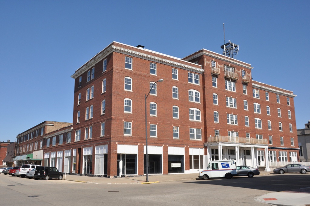
Hotel Kaskaskia
Monument and historic site · National Register of Historic Places · 2.8 mi
Historic building in LaSalle, Illinois, US
Julius W. Hegeler I House
Monument and historic site · National Register of Historic Places · 3.0 mi
Historic house in Illinois, United States

LaSalle City Building
Monument and historic site · National Register of Historic Places · 2.8 mi
Rathaus in LaSalle, United States of America

LaSalle Downtown Commercial District
Monument and historic site · National Register of Historic Places · 2.8 mi
Historic district in Illinois, United States
Parks, trails and playgrounds4

Restaurants and cafes5




History
Oglesby was a center for mining coal, limestone, and silica, located near the confluence of the Illinois River and the north-flowing Vermilion River. Oglesby grew from an amalgamation of several mining villages, such as Kenosha, Portland, and Black Hollow. It was originally called Portland, due to the cement mined and manufactured in the area that was similar to Portland Cement from England. It was renamed in 1913 after the coal company and in honor of Richard J. Oglesby (1824–1899), a former U.S. Senator and three-time Governor of Illinois.
During the Civil War, the Kenosha Coal Company sank a coal mining shaft at Oglesby in 1865. Thatcher Tucker Bent purchased the mine and mineral rights as the Oglesby Coal Company. The mine was innovative and the Bents were very involved in the development of the community. Mrs. Josephine Bent even organized English classes for the immigrant miners' wives. The Marquette Cement Manufacturing Company mined limestone and claimed that the Bent's mine was causing collapses. The conflict eventually liquidated the Oglesby Coal Company, with the Bent selling the machinery to Marquette and auctioning off the farm animals. The Black Hollow Mine was dug in the 1890s as a slope mine along the Vermilion River. It provided coal to its owners, the Illinois Zinc Company in Peru, Illinois.
From the History section of Oglesby, Illinois on Wikipedia, under CC BY-SA 4.0.
Where to stay2
Churches and places of worship3
Gas and EV charging6
Schools, colleges and libraries21
Map of Oglesby
51 places. The map loads OpenStreetMap tiles when you open it.
Climate by month
Monthly table
| Month | High | Low | Rain | Snow |
|---|---|---|---|---|
| Jan | 30°F | 14°F | 1.8 in | 8.6 in |
| Feb | 34°F | 18°F | 1.8 in | 5.5 in |
| Mar | 48°F | 27°F | 2.3 in | 4.0 in |
| Apr | 61°F | 38°F | 3.8 in | 0.6 in |
| May | 72°F | 49°F | 4.5 in | 0.0 in |
| Jun | 81°F | 59°F | 4.6 in | 0.0 in |
| Jul | 84°F | 63°F | 3.9 in | 0.0 in |
| Aug | 82°F | 61°F | 3.7 in | 0.0 in |
| Sep | 77°F | 53°F | 3.4 in | 0.0 in |
| Oct | 64°F | 41°F | 3.5 in | 0.2 in |
| Nov | 48°F | 30°F | 2.7 in | 0.9 in |
| Dec | 36°F | 20°F | 2.1 in | 8.7 in |
U.S. Climate Normals 1991-2020 for Peru (4 mi away), NOAA NCEI.
People and cost of living
American Community Survey 5-year estimates, 2020-2024, U.S. Census Bureau. Estimates have margins of error, larger for small towns.
Disaster history
LaSalle County has had 11 federal disaster declarations since 2000, most often for snowstorms.
- 2020-03-26: Covid-19 Pandemic (Biological)
- 2020-03-13: Covid-19 (Biological)
- 2013-11-26: Severe Storms, Straight-Line Winds, And Tornadoes (Tornado)
- 2013-05-10: Severe Storms, Straight-Line Winds, And Flooding (Flood)
- 2011-03-17: Severe Winter Storm And Snowstorm (Snowstorm)
- 2008-10-03: Severe Storms And Flooding (Severe Storm)
OpenFEMA disaster declarations summaries.
Getting there and nearby towns
Illinois Valley Regional Airport (VYS) is the nearest airport with scheduled flights listed in OpenStreetMap, 6 miles away.
- LaSalle 3 mi northwest, about 5 min by car
- North Utica 5 mi northeast, about 8 min by car
- Peru 6 mi northwest, about 9 min by car
- Spring Valley 6 mi west, about 10 min by car
- Granville 8 mi west, about 14 min by car
- Ladd 10 mi northwest, about 15 min by car
- Ottawa 14 mi east, about 22 min by car
- Streator 17 mi southeast, about 28 min by car
- Mendota 18 mi north, about 29 min by car
- Princeton 21 mi west, about 34 min by car
Drive times are estimates from straight-line distance, not routes.
Local news
Headlines from INDB, the NEMICO news database.
Reviews, tips and questions
Loading what members have shared...
Sources and licences
- NCES EDGE (Public domain): public schools
- NOAA NCEI U.S. Climate Normals 1991-2020 (Public domain): climate by month
- OpenFEMA (Public domain): disaster declarations
- OpenStreetMap contributors (ODbL 1.0): places, airports, map data
- U.S. Census Bureau (Public domain): population, income, housing, education, commute
- Wikidata (CC0 1.0): elevation, founding date, time zone, website, landmarks and historic places
- Wikimedia Commons (see each image): photos
- Wikipedia (CC BY-SA 4.0): overview and history text
Photo credits
- OglesbyWatertower, Hourick, Public domain
- Oglesby updated water tower, Ticksmentat, CC BY-SA 4.0
- Oglesby Tower 2 - panoramio, Corey Coyle, CC BY 3.0
- LaSalleIL JuliusWHegelerIHouse, User:Magicpiano, CC BY-SA 4.0
- LaSalleIL HotelKaskaskia, User:Magicpiano, CC BY-SA 4.0
- ASalle Downtown Commercial District, Jim Roberts, CC BY-SA 4.0
- LaSalleIL CityBuilding, User:Magicpiano, CC BY-SA 4.0
- Hegeler-Carus Mansion (8765254143), Teemu008 from Palatine, Illinois, CC BY-SA 2.0
- I-39lincolnbridge1, Lpangelrob at en.wikipedia, Public domain
- Exelon Power Lines - panoramio (2), Corey Coyle, CC BY 3.0
- Exelon Power Lines - panoramio (1), Corey Coyle, CC BY 3.0
- Pelicans on Illinois River, Joseph Norton and Ronald Frazier, CC BY 2.0
- ISS067-E-164170 - View of Earth, Earth Science and Remote Sensing Unit , Lyndon B. Johnson Space Center, Public domain
- ISS063-E-38502 - View of Earth, Earth Science and Remote Sensing Unit, NASA Johnson Space Center, Public domain
- ISS063-E-38500 - View of Earth, Earth Science and Remote Sensing Unit, NASA Johnson Space Center, Public domain
- ISS067-E-172695 - View of Earth, Earth Science and Remote Sensing Unit , Lyndon B. Johnson Space Center, Public domain
- ISS054-E-56344 - View of Earth, Earth Science and Remote Sensing Unit, NASA Johnson Space Center, Public domain
- ISS067-E-172696 - View of Earth, Earth Science and Remote Sensing Unit , Lyndon B. Johnson Space Center, Public domain
- ISS008-E-6541 - View of Missouri, Earth Science and Remote Sensing Unit , Lyndon B. Johnson Space Center, Public domain
- ISS067-E-164171 - View of Earth, Earth Science and Remote Sensing Unit , Lyndon B. Johnson Space Center, Public domain
- ISS063-E-38501 - View of Earth, Earth Science and Remote Sensing Unit, NASA Johnson Space Center, Public domain
- Illinois River bridge. I-39 crossing the Illinois River valley on the Abraham Lincoln Bridge, Ron Frazier, CC BY 2.0
- St. Hyacinths Catholic Church LaSalle, IL - panoramio, Corey Coyle, CC BY 3.0
- Phenacobius mirabilis - Gojilynx - 606630981, Gojilynx, CC BY 4.0
- Phenacobius mirabilis - Gojilynx - 606630980, Gojilynx, CC BY 4.0
- Percina caprodes - Gojilynx - 606630975, Gojilynx, CC BY 4.0
- Percina caprodes - Gojilynx - 606630974, Gojilynx, CC BY 4.0
- Percina maculata 115098035, moxostoma, CC BY 4.0
- Hiodon tergisus 311027851, moxostoma, CC BY 4.0
- I-39 South of Peru, Illinois (9181543036), Ken Lund from Reno, Nevada, USA, CC BY-SA 2.0
- I-39 South of Peru, Illinois (9179329225), Ken Lund from Reno, Nevada, USA, CC BY-SA 2.0
- Illinois River bridges. LaSalle Railroad Bridge, Ron Frazier, CC BY 2.0
- LaSalle Rail Bridge, Martin Stupich, Public domain
- La Salle Rail Bridge - panoramio, Corey Coyle, CC BY 3.0
- I-39lincolnbridge2, The original uploader was Lpangelrob at English Wikipedia ., Public domain
- Hanging on to Green (49760352958), Joseph Gage from Yorkville, IL, USA, CC BY-SA 2.0
- Lower Dells Fall (49761135352), Joseph Gage from USA, CC BY-SA 2.0
- Illinois River A Lincoln Mem Bridge, Joseph Norton and Ronald Frazier, CC BY 2.0
- Illinois River near LaSalle Illinois, Joseph Norton and Ronald Frazier, CC BY 2.0
- Illinois River at LaSalle. Shot with a DJI Phantom 4 camera drone, Ronald Douglas Frazier, CC BY 2.0


Page built October 30, 2026. Spotted a mistake? Tell us or suggest a place.