


Why visit Oley
Townapedia lists 7 museums and landmarks, 1 park or trail, 6 places to eat, 1 place to stay and 2 attractions in and around town.
Highlights include Pleasantville Bridge, Keim Homestead and Mill at Lobachsville.
July is the warmest month, with average highs of 86°F; January lows average 23°F.
Weather in Oley
Forecast from the National Weather Service. Full forecast
About Oley
Oley, previously known as Friedensburg, is a census-designated place (CDP) that is located on Routes 73 and 662 in northern Oley Township, Berks County, United States.
From the Wikipedia article Oley, Pennsylvania (this version), under CC BY-SA 4.0.
Things to do2

Pleasantville Bridge
Bridge · National Register of Historic Places · 2.6 mi
Bridge in Manatawny, Pennsylvania

Museums and landmarks7

Keim Homestead
Monument and historic site · National Register of Historic Places · 2.5 mi
Building in Pennsylvania, United States

Mill at Lobachsville
Monument and historic site · National Register of Historic Places · 3.3 mi
Building in Pennsylvania, United States

Oley Township
Monument and historic site · National Register of Historic Places · 1.7 mi
Township in Berks County, Pennsylvania

Reiff Farm
Monument and historic site · National Register of Historic Places · 1.2 mi
Building in Pennsylvania, United States
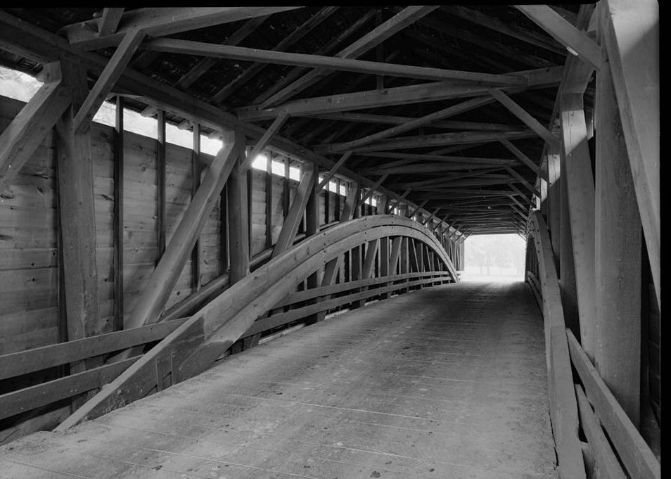
Greisemer's Mill Bridge
Bridge · National Register of Historic Places · 3.2 mi

Hartman Cider Press
Monument and historic site · National Register of Historic Places · 2.5 mi

Knabb-Bieber Mill
Monument and historic site · National Register of Historic Places · 2.4 mi
Parks, trails and playgrounds1

Restaurants and cafes6





History
A post office named Oley Furnace was established in 1828 and renamed as Oley in 1836. The community took its name from Oley Township.
The entire township is listed on the National Register of Historic Places.
From the History section of Oley, Pennsylvania on Wikipedia, under CC BY-SA 4.0.
Where to stay1
Churches and places of worship3
Shopping2
Gas and EV charging2
Schools, colleges and libraries17
Berks Career And Technology Center-East Campus
School · 0.6 mi
3307 Friedensburg Road, Oley
Healthcare1
Map of Oley
42 places. The map loads OpenStreetMap tiles when you open it.
Climate by month
Monthly table
| Month | High | Low | Rain |
|---|---|---|---|
| Jan | 39°F | 23°F | 3.6 in |
| Feb | 42°F | 24°F | 2.9 in |
| Mar | 50°F | 32°F | 4.2 in |
| Apr | 63°F | 42°F | 3.9 in |
| May | 73°F | 52°F | 3.9 in |
| Jun | 82°F | 61°F | 4.9 in |
| Jul | 86°F | 66°F | 5.4 in |
| Aug | 84°F | 64°F | 4.8 in |
| Sep | 78°F | 57°F | 4.9 in |
| Oct | 66°F | 46°F | 4.6 in |
| Nov | 54°F | 36°F | 3.3 in |
| Dec | 44°F | 28°F | 4.1 in |
U.S. Climate Normals 1991-2020 for Reading 4 Nnw Hcn (8 mi away), rain and snow from Fleetwood 2.0 Ese, NOAA NCEI.
People and cost of living
American Community Survey 5-year estimates, 2020-2024, U.S. Census Bureau. Estimates have margins of error, larger for small towns.
Disaster history
Berks County has had 13 federal disaster declarations since 2000, most often for severe storms.
- 2020-03-30: Covid-19 Pandemic (Biological)
- 2020-03-13: Covid-19 (Biological)
- 2016-03-23: Severe Winter Storm And Snowstorm (Snowstorm)
- 2012-10-29: Hurricane Sandy (Hurricane)
- 2011-09-12: Tropical Storm Lee (Flood)
- 2011-09-08: Remnants Of Tropical Storm Lee (Flood)
OpenFEMA disaster declarations summaries.
Getting there and nearby towns
Reading Municipal Airport (RDG) is the nearest airport with scheduled flights listed in OpenStreetMap, 10 miles away.
- Reading 8 mi southwest, about 13 min by car
- Muhlenberg Park 8 mi west, about 13 min by car
- New Berlinville 9 mi east, about 14 min by car
- Fox Chase 9 mi west, about 15 min by car
- Wyomissing 10 mi west, about 16 min by car
- Flying Hills 10 mi southwest, about 16 min by car
- Colony Park 11 mi west, about 17 min by car
- Bally 11 mi east, about 17 min by car
- Pottstown 12 mi southeast, about 20 min by car
- Hereford 13 mi east, about 21 min by car
Drive times are estimates from straight-line distance, not routes.
Local news
Headlines from INDB, the NEMICO news database.
Reviews, tips and questions
Loading what members have shared...
Sources and licences
- NCES EDGE (Public domain): public schools
- NOAA NCEI U.S. Climate Normals 1991-2020 (Public domain): climate by month
- OpenFEMA (Public domain): disaster declarations
- OpenStreetMap contributors (ODbL 1.0): places, airports, map data
- U.S. Census Bureau (Public domain): population, income, housing, education, commute
- Wikidata (CC0 1.0): elevation, founding date, time zone, website, landmarks and historic places
- Wikimedia Commons (see each image): photos
- Wikipedia (CC BY-SA 4.0): overview and history text
Photo credits
- Milloth House 2 Oley Village BerksCo PA, Smallbones, CC BY-SA 3.0
- Friedens UCC Oley BerksCo PA, Smallbones, CC BY-SA 3.0
- 2022-08-30 14 53 52 View east along Pennsylvania State Route 73 and south along Pennsylvania State Route 662 (Memorial Highway) just west of Lynx Drive and Philadelphia Avenue in Oley Township, Berks..., Famartin, CC BY-SA 4.0
- 2022-08-30 08 49 39 View west along Pennsylvania State Route 73 and north along Pennsylvania State Route 662 (Memorial Highway) just northwest of Philadelphia Avenue in Oley Township, Berks County..., Famartin, CC BY-SA 4.0
- PA 73 eb-PA 662 sb entering Oley, Sept. 2025, Mr. Matté (if there is an issue with this image, contact me using this image's Commons talk page , my Commons user talk page , or my English Wikipedia user talk page ; I'll know about it a lot faster), CC BY-SA 4.0
- 2022-08-30 14 55 02 View east along Pennsylvania State Route 73 (Philadelphia Avenue) just east of Pennsylvania State Route 662 (Memorial Highway) and Lynx Drive in Oley Township, Berks County..., Famartin, CC BY-SA 4.0
- 2022-08-30 17 22 17 View west along Pennsylvania State Route 73 (Philadelphia Avenue) just east of Pennsylvania State Route 662 (Memorial Highway) and Lynx Drive in Oley Township, Berks County..., Famartin, CC BY-SA 4.0
- 2022-08-30 17 24 07 View south along Pennsylvania State Route 662 (Memorial Highway) just south of Pennsylvania State Route 73 (Philadelphia Avenue) and Lynx Drive in Oley Township, Berks County..., Famartin, CC BY-SA 4.0
- 2022-08-30 08 48 33 View north along Pennsylvania State Route 662 (Memorial Highway) just south of Pennsylvania State Route 73 (Philadelphia Avenue) in Oley Township, Berks County, Pennsylvania, Famartin, CC BY-SA 4.0
- 2022-08-30 08 52 14 View west along Pennsylvania State Route 73 and north along Pennsylvania State Route 662 (Memorial Highway) just southeast of Oley Road in Oley Township, Berks County, Pennsylvania, Famartin, CC BY-SA 4.0
- Reiff Farm 4 Oley BerksCo PA, Smallbones, CC BY-SA 3.0
- Reiff Farm 3 Oley BerksCo PA, Smallbones, CC BY-SA 3.0
- Reiff farm Oley BerksCo PA, Smallbones, CC BY-SA 3.0
- Reiff Farm 2 Oley BerksCo PA, Smallbones, CC BY-SA 3.0
- 2022-08-30 14 50 38 View east along Pennsylvania State Route 73 and south along Pennsylvania State Route 662 (Memorial Highway) just east of Oley Road in Oley Township, Berks County, Pennsylvania, Famartin, CC BY-SA 4.0
- 2022-08-30 13 48 16 View south along Pennsylvania State Route 662 (Oley Road) just north of Pennsylvania State Route 73 (Blandon Road) in Ruscombmanor Township, Berks County, Pennsylvania, Famartin, CC BY-SA 4.0
- 2022-08-30 08 54 52 View north along Pennsylvania State Route 662 (Memorial Highway) just north of Oley Road and Main Street in Ruscombmanor Township, Berks County, Pennsylvania, Famartin, CC BY-SA 4.0
- 2022-08-30 08 53 33 View north along Pennsylvania State Route 662 (Oley Road) just north of Pennsylvania State Route 73 (Blandon Road) in Ruscombmanor Township, Berks County, Pennsylvania, Famartin, CC BY-SA 4.0
- 2022-08-30 13 51 05 View west along Pennsylvania State Route 73 (Blandon Road) just west of Pennsylvania State Route 662 (Oley Road) in Ruscombmanor Township, Berks County, Pennsylvania, Famartin, CC BY-SA 4.0
- 2022-08-30 14 48 38 View east along Pennsylvania State Route 73 (Blandon Road) just west of Pennsylvania State Route 662 (Oley Road) in Ruscombmanor Township, Berks County, Pennsylvania, Famartin, CC BY-SA 4.0
- Pleasantville Covered Bridge Oct 09, Doug Kerr from Albany, NY, United States, CC BY-SA 2.0
- Keim Homestead 03, Hshuvaeva, CC BY-SA 3.0
- Mill at Lobachsville 01, Hshuvaeva, CC BY-SA 3.0
- Oley Township, Doug Kerr, CC BY-SA 2.0
- Griesemer Mill Covered Bridge, 3.5 miles north of State Route 562, spanning Manat, Yellow House vicinity (Berks County, Pennsylvania), Cervin Robinson, Photographer, Public domain
- Knabb-Bieber Mill, Cervin Robinson, Public domain
- Hartman Cider Press 02, Hshuvaeva, CC BY-SA 3.0
- ISS067-E-137165 - View of Earth, Earth Science and Remote Sensing Unit , Lyndon B. Johnson Space Center, Public domain
- ISS062-E-115755 - View of Earth, Earth Science and Remote Sensing Unit, NASA Johnson Space Center, Public domain
- ISS061-E-112525 - View of Earth, Earth Science and Remote Sensing Unit, NASA Johnson Space Center, Public domain
- Flickr - Nicholas T - Sacred Oak, Nicholas A. Tonelli from Pennsylvania, USA, CC BY 2.0
- Flickr - Nicholas T - Oxidation, Nicholas A. Tonelli from Pennsylvania, USA, CC BY 2.0
- DJI 0447-001, Wilderf353, CC BY-SA 4.0


Page built October 30, 2026. Spotted a mistake? Tell us or suggest a place.