
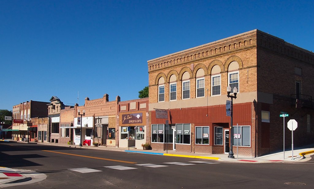


Ortonville, Minnesota
Ortonville is a city of 2,028 people in Big Stone County, Minnesota.
Why visit Ortonville
Townapedia lists 4 museums and landmarks, 8 parks and trails, 4 places to eat and 3 places to stay in and around town.
Highlights include Big Stone County Courthouse.
July is the warmest month, with average highs of 81°F; January lows average 4°F.
Weather in Ortonville
Forecast from the National Weather Service. Full forecast
About Ortonville
Ortonville is a city in and the county seat of Big Stone County in the U.S. state of Minnesota at the southern tip of Big Stone Lake, along the South Dakota border. The population was 2,021 at the 2020 census. Big Stone Lake State Park is nearby.
From the Wikipedia article Ortonville, Minnesota (this version), under CC BY-SA 4.0.
Museums and landmarks4

Big Stone County Courthouse
Monument and historic site · National Register of Historic Places
Center of government for Big Stone County, Minnesota

Parks, trails and playgrounds8


Restaurants and cafes4


Subway
Fast food · Sandwich
701 2nd Street Southeast, Ortonville
Where to stay3




History
Ortonville was platted in 1872 by and named for Cornelius Knute Orton. Ortonville was incorporated as a city in 1881. The Big Stone County Courthouse was built in 1902.
From the History section of Ortonville, Minnesota on Wikipedia, under CC BY-SA 4.0.
Churches and places of worship4
Shopping1
Gas and EV charging1
Schools, colleges and libraries8
Healthcare1
Map of Ortonville
34 places. The map loads OpenStreetMap tiles when you open it.
Climate by month
Monthly table
| Month | High | Low | Rain |
|---|---|---|---|
| Jan | 21°F | 4°F | 0.7 in |
| Feb | 26°F | 7°F | 0.7 in |
| Mar | 38°F | 19°F | 1.2 in |
| Apr | 54°F | 32°F | 2.4 in |
| May | 67°F | 44°F | 2.9 in |
| Jun | 77°F | 56°F | 3.9 in |
| Jul | 81°F | 60°F | 3.8 in |
| Aug | 79°F | 57°F | 3.2 in |
| Sep | 72°F | 48°F | 2.6 in |
| Oct | 58°F | 35°F | 2.3 in |
| Nov | 41°F | 22°F | 0.9 in |
| Dec | 26°F | 10°F | 0.8 in |
U.S. Climate Normals 1991-2020 for Milbank (10 mi away), NOAA NCEI.
People and cost of living
American Community Survey 5-year estimates, 2020-2024, U.S. Census Bureau. Estimates have margins of error, larger for small towns.
Disaster history
Big Stone County has had 13 federal disaster declarations since 2000, most often for floods.
- 2023-07-19: Severe Storms And Flooding (Flood)
- 2022-08-09: Severe Storms, Straight-Line Winds, Tornadoes, And Flooding (Severe Storm)
- 2022-07-08: Severe Storms, Straight-Line Winds, Tornadoes, And Flooding (Severe Storm)
- 2020-04-07: Covid-19 Pandemic (Biological)
- 2020-03-13: Covid-19 (Biological)
- 2019-06-12: Severe Winter Storm, Straight-Line Winds, And Flooding (Flood)
OpenFEMA disaster declarations summaries.
Getting there and nearby towns
Morris Municipal Airport (MOX) is the nearest airport with scheduled flights listed in OpenStreetMap, 29 miles away.
- Appleton 22 mi east, about 35 min by car
- Madison 23 mi southeast, about 38 min by car
- Dawson 32 mi southeast, about 52 min by car
- Morris 33 mi northeast, about 52 min by car
- Benson 41 mi east, about 1 h by car
- Canby 41 mi south, about 1 h by car
- Montevideo 43 mi southeast, about 1 h 15 min by car
- Watertown 44 mi southwest, about 1 h 15 min by car
- Elbow Lake 52 mi northeast, about 1 h 30 min by car
- Granite Falls 56 mi southeast, about 1 h 30 min by car
Drive times are estimates from straight-line distance, not routes.
Local news
Headlines from INDB, the NEMICO news database.
Reviews, tips and questions
Loading what members have shared...
Sources and licences
- NCES EDGE (Public domain): public schools
- NOAA NCEI U.S. Climate Normals 1991-2020 (Public domain): climate by month
- OpenFEMA (Public domain): disaster declarations
- OpenStreetMap contributors (ODbL 1.0): places, airports, map data
- U.S. Census Bureau (Public domain): population, income, housing, education, commute
- Wikidata (CC0 1.0): elevation, founding date, time zone, website, landmarks and historic places
- Wikimedia Commons (see each image): photos
- Wikipedia (CC BY-SA 4.0): overview and history text
Photo credits
- Ortonville Commercial HD, McGhiever, CC BY-SA 3.0
- Big Stone County Court House, Ortonville, Minnesota (29241156311), Tony Webster from Minneapolis, Minnesota, CC BY-SA 2.0
- Big Stone County Court House - Ortonville - Minnesota (54583564212), Tony Webster, CC BY 2.0
- Big Stone County Court House, Ortonville, Minnesota (35397051831), Tony Webster, CC BY 2.0
- Columbian Hotel (Ortonville MN), Unknown author Unknown author, Public domain
- Big Stone Lake from Ortonville, McGhiever, CC BY-SA 3.0
- Ortonville Free Library, McGhiever, CC BY-SA 3.0
- Ortonville City Water Department Building - 1933 - Minnesota (34686306904), Tony Webster from Minneapolis, Minnesota, United States, CC BY-SA 2.0
- Bethany Evangelical Lutheran Church, Ortonville, Minnesota, Myotus, CC BY-SA 4.0
- Big Stone County Courthouse, McGhiever, CC BY-SA 3.0
- 1992 Oldsmobile Cutlass Cruiser SL (24235814076), Greg Gjerdingen from Willmar, USA, CC BY 2.0
- 1992 Oldsmobile Cutlass Cruiser SL (24235821236), Greg Gjerdingen from Willmar, USA, CC BY 2.0
- 1992 Oldsmobile Cutlass Cruiser SL (24235830496), Greg Gjerdingen from Willmar, USA, CC BY 2.0
- 1992 Oldsmobile Cutlass Cruiser SL (24235827766), Greg Gjerdingen from Willmar, USA, CC BY 2.0
- 2017 Toyota Rav4 XLE Hybrid AWD-I (36716049250), Greg Gjerdingen from Willmar, USA, CC BY 2.0
- 2017 Toyota Rav4 XLE Hybrid AWD-I (36716048050), Greg Gjerdingen from Willmar, USA, CC BY 2.0
- Columbian Hotel, McGhiever, CC BY-SA 3.0
- 1979 Lincoln Versailles - Flickr - Crown Star Images, Greg Gjerdingen from Willmar, USA, CC BY 2.0
- Big Stone County Museum, McGhiever, CC BY-SA 3.0
- District No. 13 School, McGhiever, CC BY-SA 3.0
- Engebrecht Peterson log cabin and 1898 District 13 School, Myotus, CC BY-SA 4.0
- Charles Hanson Wild Life Display, Myotus, CC BY-SA 4.0
- Gold House NRHP 08000046 Grant County, SD, Jon Roanhaus, CC BY-SA 3.0
- Big Stone City Hall NRHP 04000764 Grant County, SD, Jon Roanhaus, CC BY-SA 3.0
- ISS016-E-16606 - View of Minnesota, Earth Science and Remote Sensing Unit , Lyndon B. Johnson Space Center, Public domain


Page built October 30, 2026. Spotted a mistake? Tell us or suggest a place.