



Ottumwa, Iowa
Ottumwa is a city of 25,430 people in Wapello County, Iowa, founded in 1844.
Why visit Ottumwa
Townapedia lists 28 museums and landmarks, 23 parks and trails, 57 places to eat, 11 places to stay and 3 attractions in and around town.
Highlights include CEC Ottumwa 8 Theatre, B'nai Jacob Synagogue, Foster/Bell House and Ottumwa Country Club.
July is the warmest month, with average highs of 86°F; January lows average 14°F, and about 24 inches of snow fall in a normal year.
Weather in Ottumwa
Forecast from the National Weather Service. Full forecast
About Ottumwa
Ottumwa is a city in and the county seat of Wapello County, Iowa, United States. The population was 25,529 at the time of the 2020 U.S. census. Located in the state's southeastern section, the city is split into northern and southern halves by the Des Moines River.
From the Wikipedia article Ottumwa, Iowa (this version), under CC BY-SA 4.0.
Things to do3

Museums and landmarks28

B'nai Jacob Synagogue
Monument and historic site · National Register of Historic Places · 1.0 mi
Listed on the National Register of Historic Places in Wapello County

Foster/Bell House
Monument and historic site · National Register of Historic Places · 0.8 mi
Historic house in Iowa, United States
205 East Fifth Street, Ottumwa

Benson Block
Monument and historic site · National Register of Historic Places · 0.8 mi
Building in Ottumwa, Iowa (built as a theatre, but never used as such)

Benson Building
Monument and historic site · National Register of Historic Places · 0.8 mi
NRHP-listed in Wapello County

Court Hill Historic District
Monument and historic site · National Register of Historic Places · 0.8 mi
Historic district in Iowa, United States

Dahlonega School No. 1
Monument and historic site · National Register of Historic Places · 3.7 mi
Historic school building located near Ottumwa, Iowa, United States

Fifth Street Bluff Historic District
Monument and historic site · National Register of Historic Places · 0.9 mi
Historic district in Iowa, United States

First National Bank
Monument and historic site · National Register of Historic Places · 0.7 mi
Historic structure in Ottumwa, Iowa, United States

Greater Second Street Historic District
Monument and historic site · National Register of Historic Places · 0.8 mi
Historic district in Iowa, United States

Historic Railroad District
Monument and historic site · National Register of Historic Places · 1.4 mi
Historic district in Iowa, United States

Hotel Ottumwa
Monument and historic site · National Register of Historic Places · 0.6 mi
107 East Second Street, Ottumwa

J.W. Garner Building
Monument and historic site · National Register of Historic Places · 0.7 mi
United States historic place
16 more on the map.
Parks, trails and playgrounds23






11 more on the map.
Restaurants and cafes57

Café by Country Kitchen
Restaurant · American, Coffee Shop, Brunch · 0.9 mi
1107 North Quincy Avenue, Ottumwa
Mo-Su 06:00-15:00
Godfrey's Ale House
Restaurant · 2.1 mi
Discover Godfrey’s Ale House – Ottumwa’s Top-Rated Sports Bar & Outdoor Patio Destination
2513 Northgate Street, Ottumwa
Su-Mo 11:00-21:00; Tu-Th 11:00-22:00; Fr-Sa 11:00-23:00
Ohana Grill
Restaurant · 0.8 mi
Ohana Grill, founded in 2026 in Ottumwa, IA, brings the vibrant flavors of Hawaii and the Philippines to the greater Ottumwa area. We...
207 2nd St E, Ottumwa
Su-Th 09:00-12:00, Fr-Sa 09:00-15:00

Canteen Lunch in the Alley
Restaurant · Burger · 0.7 mi
112 East Second Street, Ottumwa

Java Rocket
Cafe · 2.2 mi
Mo-Fr 06:00-17:00, Sa 06:00-14:00; Su off

Polar Xpress
Ice cream · 0.8 mi
221 East Main Street, Ottumwa
Mo-Th 00:00-20:00; Fr,Sa 00:00-21:00; Su off
Breadeaux Pizza & Champ's Chicken
Restaurant · Pizza · 0.9 mi
401 East Main Street, Ottumwa
45 more on the map.
History
The city's name derives from Fox, an Algonquian language of the native Meskwaki people, translating to 'tumbling waters' in reference to the Appanoose Rapids on the Des Moines River.
In May 1843, several investors formed the Appanoose Rapids Company and staked claim to 467 acres (189 ha) of land in the present site of Ottumwa. Their colonization involved claiming land supporting three indigenous settlements. The first official cabin was built in May 1843 after the area was opened to settlement (an earlier cabin built in defiance of this date was destroyed by Army troops at that time). The original platt was titled Louis Ville. In 1844 the city was named as the county seat.
From the History section of Ottumwa, Iowa on Wikipedia, under CC BY-SA 4.0.
Where to stay11
Oak Meadow Delight Bed and Breakfast
Motel and hotel · 2.9 mi
2814 Oak Meadow Drive, Ottumwa
Churches and places of worship48
Trinity Episcopal Church
Church · 0.8 mi
204 East Fifth Street, Ottumwa
St. Mary of the Visitation
Church · Catholic · 0.7 mi
113 East Fourth Street, Ottumwa
First Pentecostal Assembly of God Church
Church · Pentecostal · 1.1 mi
733 Church Street, Ottumwa
Albia Road Southern Baptist Church
Church · Southern Baptist · 1.5 mi
1601 Albia Road, Ottumwa
First Church of the Open Bible
Church · Protestant · 1.8 mi
1932 Albia Road, Ottumwa
First Presbyterian Church
Church · Presbyterian · 0.5 mi
228 West Fourth Street, Ottumwa
First United Methodist Church
Church · United Methodist · 0.8 mi
202 East Fourth Street, Ottumwa
Iglesia Evangelica Belen Assembly of God
Church · Assemblies Of God · 1.8 mi
1026 West Williams Street, Ottumwa
Shopping23
Gas and EV charging12
Schools, colleges and libraries24
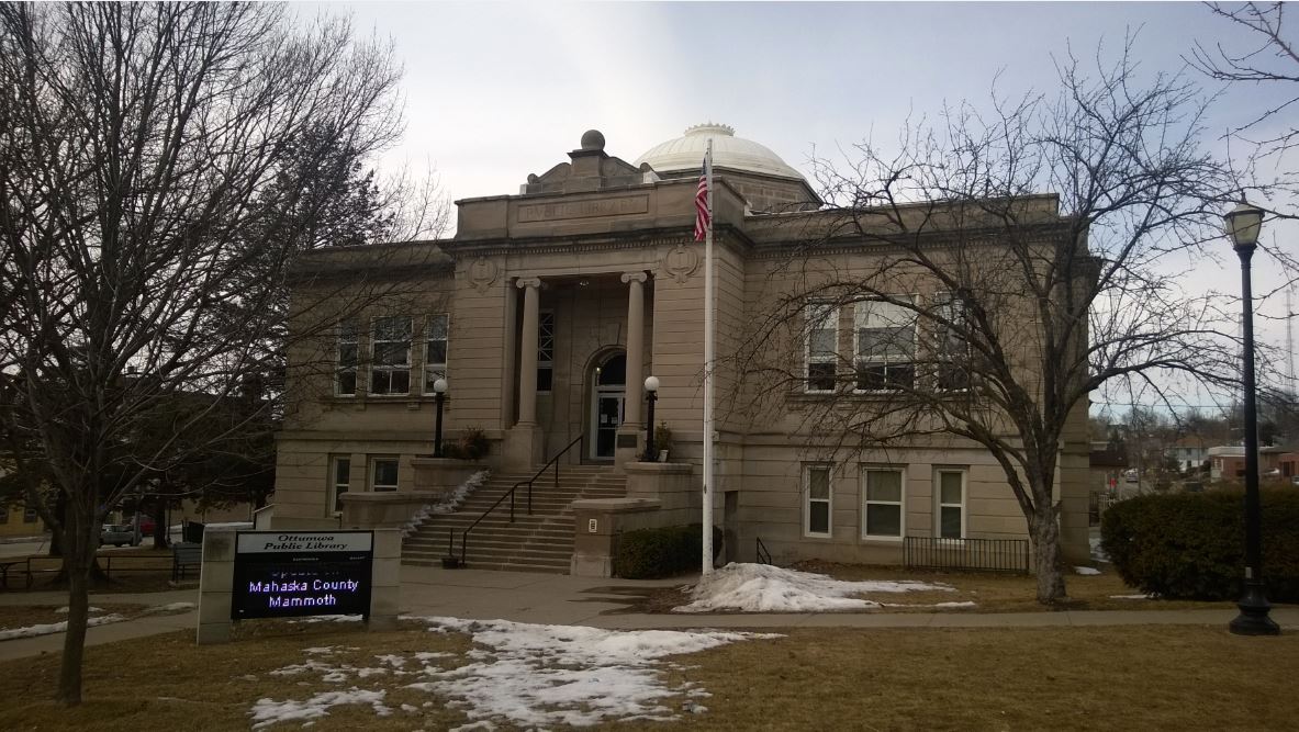
Ottumwa Public Library
Library · National Register of Historic Places · 0.6 mi
102 4th Street West, Ottumwa
Great Prairie Area Education Agency
School · 2.8 mi
2814 North Court Street, Ottumwa
Healthcare15
Hy-Vee Drugstore
Clinic and pharmacy · 1.2 mi
1140 North Jefferson Street, Ottumwa
Ottumwa Medical Clinic
Clinic and pharmacy · 1.9 mi
1005 Pennsylvania Avenue, Ottumwa
Ottumwa Sleep Clinic
Clinic and pharmacy · 1.7 mi
935 Pennsylvania Avenue, Ottumwa
Pella Regional Health Center
Clinic and pharmacy · 1.0 mi
920 North Quincy Avenue, Ottumwa
Map of Ottumwa
244 places. The map loads OpenStreetMap tiles when you open it.
Climate by month
Monthly table
| Month | High | Low | Rain | Snow |
|---|---|---|---|---|
| Jan | 32°F | 14°F | 1.0 in | 7.1 in |
| Feb | 37°F | 18°F | 1.4 in | 5.8 in |
| Mar | 50°F | 29°F | 2.2 in | 3.0 in |
| Apr | 63°F | 39°F | 3.8 in | 1.4 in |
| May | 73°F | 51°F | 5.0 in | 0.0 in |
| Jun | 82°F | 61°F | 5.4 in | 0.0 in |
| Jul | 86°F | 64°F | 3.9 in | 0.0 in |
| Aug | 84°F | 62°F | 4.4 in | 0.0 in |
| Sep | 77°F | 53°F | 3.5 in | 0.0 in |
| Oct | 64°F | 42°F | 2.8 in | 0.5 in |
| Nov | 50°F | 30°F | 2.1 in | 1.6 in |
| Dec | 37°F | 20°F | 1.4 in | 4.2 in |
U.S. Climate Normals 1991-2020 for Ottumwa Industrial Ap (6 mi away), NOAA NCEI.
People and cost of living
American Community Survey 5-year estimates, 2020-2024, U.S. Census Bureau. Estimates have margins of error, larger for small towns.
Disaster history
Wapello County has had 13 federal disaster declarations since 2000, most often for severe storms.
- 2020-03-23: Covid-19 Pandemic (Biological)
- 2020-03-13: Covid-19 (Biological)
- 2019-03-23: Severe Storms And Flooding (Flood)
- 2013-07-02: Severe Storms, Tornadoes, And Flooding (Severe Storm)
- 2013-05-31: Severe Storms, Straight-Line Winds, And Flooding (Flood)
- 2010-07-29: Severe Storms, Flooding, And Tornadoes (Severe Storm)
OpenFEMA disaster declarations summaries.
Getting there and nearby towns
Ottumwa Regional Airport (OTM) is the nearest airport with scheduled flights listed in OpenStreetMap, 6 miles away.
- Agency 6 mi east, about 10 min by car
- Hedrick 12 mi northeast, about 19 min by car
- Blakesburg 12 mi west, about 19 min by car
- Eldon 13 mi southeast, about 21 min by car
- Fremont 13 mi north, about 21 min by car
- Batavia 13 mi east, about 22 min by car
- Eddyville 14 mi northwest, about 23 min by car
- Bloomfield 19 mi south, about 30 min by car
- Albia 20 mi west, about 32 min by car
- Oskaloosa 22 mi northwest, about 35 min by car
Drive times are estimates from straight-line distance, not routes.
Local news
Headlines from INDB, the NEMICO news database.
Reviews, tips and questions
Loading what members have shared...
Sources and licences
- NCES EDGE (Public domain): public schools
- NOAA NCEI U.S. Climate Normals 1991-2020 (Public domain): climate by month
- OpenFEMA (Public domain): disaster declarations
- OpenStreetMap contributors (ODbL 1.0): places, airports, map data
- U.S. Census Bureau (Public domain): population, income, housing, education, commute
- Wikidata (CC0 1.0): elevation, founding date, time zone, website, landmarks and historic places
- Wikimedia Commons (see each image): photos
- Wikipedia (CC BY-SA 4.0): overview and history text
Photo credits
- Ottumwa Collage Photos, Gcardinal101, CC BY-SA 4.0
- Ottumwa Public Library, Dohrs16, CC BY-SA 3.0
- U.S. Post Office Ottumwa, Iowa, Boscophotos, CC BY-SA 3.0
- FosterBell House, Dohrs16, CC BY-SA 3.0
- BNaiJacobOttumwaSouthView, Douglas W. Jones, Public domain
- St. Joseph Hospital, Ottumwa, Iowa, Dohrs16, CC BY-SA 3.0
- The Benson Block, Boscophotos, CC BY-SA 3.0
- Jefferson Street Viaduct, Bruce A. Harms, Public domain
- 1239 North Fellows St, Boscophotos, CC BY-SA 3.0
- 112 N. Market St, Jim Roberts, CC BY-SA 4.0
- California Zephyr at Ottumwa, August 2017, David Wilson from Oak Park, Illinois, USA, CC BY 2.0
- OttumwaStationLongView, User:Dandoug, CC BY 2.5
- Wapello County, Iowa Courthouse, en:User:Cburnett, CC BY-SA 3.0
- The Benson Building, Boscophotos, CC BY-SA 3.0
- YWCA 1924 Ottumwa, Iowa, Dohrs16, CC BY-SA 3.0
- First National Bank Ottumwa, Mathis47, CC BY-SA 3.0
- The Court Hill Historic Distrivt, Boscophotos, CC BY-SA 3.0
- 205 E. fifth Street, Boscophotos, CC BY-SA 3.0
- Edgerly Gateway, Boscophotos, CC BY-SA 3.0
- The Jay Funeral Hall, Boscophotos, CC BY-SA 3.0
- The J.W. Garner Building, Boscophotos, CC BY-SA 3.0
- Dahlonega School No. 1, Jim Roberts, CC BY-SA 4.0
- 101 Vogel Place, Boscophotos, CC BY-SA 3.0
- Hotel Ottumwa, Ottumwa, Iowa, Chuckmor, CC BY-SA 3.0
- Hoffman Building, Jim Roberts, CC BY-SA 4.0
- Ottumwa Church, heather vescent, CC BY-SA 2.0


Page built October 30, 2026. Spotted a mistake? Tell us or suggest a place.