
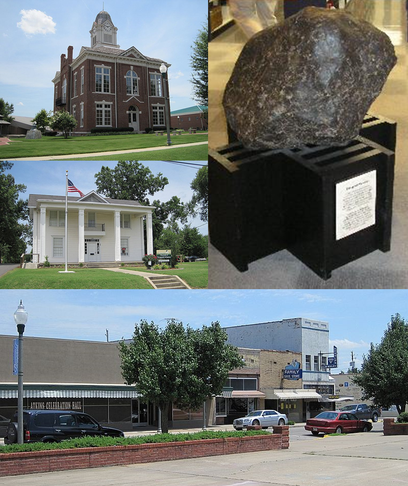


Paragould, Arkansas
Paragould is a city of 30,215 people in Greene County, Arkansas, founded in 1883.
Why visit Paragould
Townapedia lists 15 museums and landmarks, 12 parks and trails, 30 places to eat, 4 places to stay and 3 attractions in and around town.
Highlights include Paragould Cinema 8, Arkansas State University Paragould, Paragould War Memorial and Beisel-Mitchell House.
July is the warmest month, with average highs of 90°F; January lows average 28°F.
Weather in Paragould
Forecast from the National Weather Service. Full forecast
About Paragould
Paragould is a city in and the county seat of Greene County, and the 15th-largest city in Arkansas, in the United States. The city is located in northeastern Arkansas on the eastern edge of Crowley's Ridge, a geologic anomaly contained within the Arkansas Delta.
From the Wikipedia article Paragould, Arkansas (this version), under CC BY-SA 4.0.
Things to do3


Arkansas State University Paragould
School · 0.7 mi
State university secondary campus
Museums and landmarks15
Paragould War Memorial
Monument and historic site · National Register of Historic Places · 1.2 mi
War memorial in Paragould, United States of America

Beisel-Mitchell House
Monument and historic site · National Register of Historic Places · 1.1 mi
Paragould, Arkansas, NRHP-listed
George Ray's Dragstrip
Monument and historic site · National Register of Historic Places · 4.3 mi
Dragstrip in Greene County, Arkansas

Greene County Courthouse
Monument and historic site · National Register of Historic Places · 1.3 mi
Courthouse in Arkansas, United States
Gulf Oil Company Service Station
Monument and historic site · National Register of Historic Places · 1.3 mi
Filling station in Paragould, United States of America
Highfill-McClure House
Monument and historic site · National Register of Historic Places · 1.0 mi
Paragould, Arkansas, listed on the NRHP in Greene County, Arkansas
Jackson-Herget House
Monument and historic site · National Register of Historic Places · 1.1 mi
Paragould, Arkansas, NRHP-listed in Greene County
Linwood Mausoleum
Monument and historic site · National Register of Historic Places · 0.4 mi
Mausoleum in Linwood Cemetery, Paragould, Arkansas, United States
National Bank of Commerce Building (Paragould, Arkansas)
Monument and historic site · National Register of Historic Places · 1.4 mi
Bank building in Paragould, United States of America
Paragould Downtown Commercial Historic District
Monument and historic site · National Register of Historic Places · 1.4 mi
Historic district in Arkansas, United States
St. Mary's Catholic Church
Monument and historic site · National Register of Historic Places · 1.4 mi
Church building in Paragould, Arkansas, U.S.
Texaco Station No. 1
Monument and historic site · National Register of Historic Places · 1.4 mi
3 more on the map.
Parks, trails and playgrounds12





Restaurants and cafes30

Shadrachs Coffee
Cafe · Coffee Shop
1600 West Kings Highway, Paragould
Mo-Fr 05:30-21:00; Sa 06:30-21:00

Something Sweet
Bakery · 1.4 mi
221 South Pruett Street, Paragould
Tu,We 08:00-18:00; Th-Fr 07:00-20:00; Sa 09:00-16:00


Casa Brava
Restaurant · Mexican · 0.9 mi
701 West Kings Highway, Paragould
Su-Th 11:00-21:00; Fr-Sa 11:00-22:00
Batten's Bakery
Bakery
1725 West Kings Highway, Paragould
Tu-Fr 05:30-12:00; Sa 06:00-11:00


Downtown Bar & Grill
Bar and pub · 1.4 mi
215 South Pruett Street, Paragould

Dairy Queen
Fast food · Ice Cream, Burger, Chicken · 1.1 mi
508 South 4th Street, Paragould
Mo-Th 09:30-21:00; Fr 09:30-22:00; Sa 10:30-22:00
18 more on the map.
History
The city's name is a blend combining the last names of competing railroad magnates J. W. Paramore and Jay Gould. Paramore's Texas & St. Louis Railway (later the Cotton Belt) and Gould's St. Louis, Iron Mountain and Southern Railway (later the Missouri Pacific) intersected here in 1882. A group of citizens chose the name, and it is believed to be the only city in the world with this name. For a time, Gould objected to his name's being second and refused to list the new town on his schedules. In 1888, Paragould was the starting point for the Paragould and Buffalo Island Railway (later the Paragould Southeastern Railway), which eventually made its way to Blytheville, Arkansas.
From the History section of Paragould, Arkansas on Wikipedia, under CC BY-SA 4.0.
Where to stay4
Churches and places of worship41
Saint Mary Catholic Church
Church · Roman Catholic · 1.3 mi
300 North 2nd Street, Paragould
Shopping8
Gas and EV charging14
Schools, colleges and libraries29
Greene Cty Tech Intermediate School
School · 2.7 mi
5205 W Kingshighway, Paragould
Greene Cty Tech Junior High School
School · 2.5 mi
5207 W Kingshighway, Paragould
Healthcare4
Map of Paragould
160 places. The map loads OpenStreetMap tiles when you open it.
Climate by month
Monthly table
| Month | High | Low | Rain | Snow |
|---|---|---|---|---|
| Jan | 46°F | 28°F | 3.9 in | 1.0 in |
| Feb | 50°F | 31°F | 4.0 in | 0.8 in |
| Mar | 60°F | 40°F | 4.9 in | 0.4 in |
| Apr | 70°F | 49°F | 5.2 in | 0.0 in |
| May | 79°F | 59°F | 5.1 in | 0.0 in |
| Jun | 87°F | 68°F | 3.6 in | 0.0 in |
| Jul | 90°F | 71°F | 4.2 in | 0.0 in |
| Aug | 89°F | 69°F | 3.8 in | 0.0 in |
| Sep | 83°F | 62°F | 3.3 in | 0.0 in |
| Oct | 73°F | 50°F | 4.4 in | 0.0 in |
| Nov | 59°F | 39°F | 4.6 in | 0.0 in |
| Dec | 49°F | 32°F | 4.6 in | 0.3 in |
U.S. Climate Normals 1991-2020 for Paragould 1S (1 mi away), NOAA NCEI.
People and cost of living
American Community Survey 5-year estimates, 2020-2024, U.S. Census Bureau. Estimates have margins of error, larger for small towns.
Disaster history
Greene County has had 21 federal disaster declarations since 2000, most often for severe storms.
- 2026-01-24: Severe Winter Storm (Winter Storm)
- 2025-05-21: Severe Storms, Tornadoes, And Flooding (Flood)
- 2025-05-08: Severe Storms And Tornadoes (Severe Storm)
- 2025-04-05: Severe Storms, Tornadoes, And Flooding (Severe Storm)
- 2024-05-30: Severe Storms, Straight-Line Winds, Tornadoes, And Flooding (Severe Storm)
- 2020-08-27: Hurricane Laura (Hurricane)
OpenFEMA disaster declarations summaries.
Getting there and nearby towns
Kirk Field (PGR) is the nearest airport with scheduled flights listed in OpenStreetMap, 1 miles away.
- Oak Grove Heights 5 mi north, about 9 min by car
- Walcott 9 mi west, about 14 min by car
- Brookland 11 mi south, about 18 min by car
- Lafe 11 mi north, about 17 min by car
- Marmaduke 12 mi northeast, about 19 min by car
- Cardwell 12 mi east, about 20 min by car
- Monette 14 mi southeast, about 23 min by car
- Lake City 16 mi south, about 26 min by car
- Jonesboro 19 mi southwest, about 30 min by car
- Blytheville 35 mi east, about 56 min by car
Drive times are estimates from straight-line distance, not routes.
Local news
Headlines from INDB, the NEMICO news database.
Reviews, tips and questions
Loading what members have shared...
Sources and licences
- NCES EDGE (Public domain): public schools
- NOAA NCEI U.S. Climate Normals 1991-2020 (Public domain): climate by month
- OpenFEMA (Public domain): disaster declarations
- OpenStreetMap contributors (ODbL 1.0): places, airports, map data
- U.S. Census Bureau (Public domain): population, income, housing, education, commute
- Wikidata (CC0 1.0): elevation, founding date, time zone, website, landmarks and historic places
- Wikimedia Commons (see each image): photos
- Wikipedia (CC BY-SA 4.0): overview and history text
Photo credits
- Paragould collage, Brandonrush, CC BY-SA 3.0
- St. Mary's Catholic Church Paragould, Arkansas, Chrisbouldin, CC BY-SA 4.0
- Paragould AR 2011 06 23 013, Thomas R Machnitzki ([email protected]), CC BY 3.0
- Linwood Mausuleum Paragould AR 001, Thomas R Machnitzki ([email protected]), CC BY 3.0
- Paragould AR 2011 06 23 026, Thomas R Machnitzki ([email protected]), CC BY 3.0
- Paragould AR 2011 06 23 023, Thomas R Machnitzki ([email protected]), CC BY 3.0
- Paragould AR 2011 06 23 003, Thomas R Machnitzki ([email protected]), CC BY 3.0
- Highfill-McClure HouseHouse, Colinhester, CC BY-SA 3.0
- Beisel-Mitchell House, Colinhester, CC BY-SA 3.0
- Jackson-Herget House, Colinhester, CC BY-SA 3.0
- Gulf Oil Company Service Station, Colinhester, CC BY-SA 3.0
- Texaco Station No. 1, Colinhester, CC BY-SA 3.0
- ISS062-E-60276 - View of Earth, Earth Science and Remote Sensing Unit, NASA Johnson Space Center, Public domain
- ISS023-E-48660 - View of Earth, Earth Science and Remote Sensing Unit , Lyndon B. Johnson Space Center, Public domain
- ISS062-E-60277 - View of Earth, Earth Science and Remote Sensing Unit, NASA Johnson Space Center, Public domain
- George Ray's Dragstrip, Colinhester, CC BY-SA 3.0


Page built October 30, 2026. Spotted a mistake? Tell us or suggest a place.