
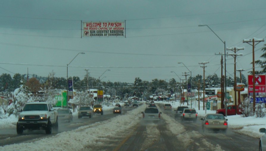


Payson, Arizona
Payson is a town of 16,622 people in Gila County, Arizona, founded in 1973.
Why visit Payson
Townapedia lists 4 museums and landmarks, 11 parks and trails, 39 places to eat, 15 places to stay and 5 attractions in and around town.
Highlights include Sawmill Theatres, Ox Bow Inn, Shoofly Village Ruin and Payson Golf Course.
July is the warmest month, with average highs of 92°F; December lows average 26°F.
Weather in Payson
Forecast from the National Weather Service. Full forecast
About Payson
Payson (Navajo: Ndzistsooí) is a town in northern Gila County, Arizona, United States. Due to Payson's location being very near to the geographic center of Arizona, it has been called "The Heart of Arizona." Payson is also considered part of the colloquially defined Northern Arizona region, and the town serves as a gateway to the vast wilderness of the Colorado Plateau. The town is surrounded by the Tonto National Forest, the largest of the six national forests in Arizona—and the ninth largest national forest in the United States.
From the Wikipedia article Payson, Arizona (this version), under CC BY-SA 4.0.
Things to do5


Museums and landmarks4


Ox Bow Inn
Monument and historic site · National Register of Historic Places · 1.3 mi
Historic hotel in Payson, Arizona

Shoofly Village Ruin
Monument and historic site · 3.9 mi
Archaeological site, Tonto National Forest, Arizona

Parks, trails and playgrounds11




Restaurants and cafes39

Bee Line Cafe
Restaurant · Breakfast, Coffee Shop, Diner · 1.1 mi
815 South Beeline Highway, Payson
05:00-15:00

Buffalo Bar and Grill
Diner · American · 0.5 mi
313 South Beeline Highway, Payson
Su-Th 11:00-21:00; Fr-Sa 11:00-22:00
Chili's
Restaurant · Tex-Mex · 1.1 mi
900 South Beeline Highway, Payson
Su-Th 11:00-21:00; Fr-Sa 11:00-22:00
Denzeisen Dairy Cremery Store
Restaurant · Ice Cream, Juice, Dessert · 0.7 mi
500 S. Beeline Hwy., Payson
Mo-Sa 07:00-20:00
Macky’s Grill
Diner · American · 1.0 mi
201 West Main Street, Payson
Tu-Sa 10:00-20:00; Su 10:00-16:00
Tiny's Family Restaurant And Lounge
Restaurant · Breakfast, Diner, American, Chicken
600 E Highway 260, Payson
Tu-Sa 06:00-20:00; Su-Mo 06:00-15:00

Dutch Bros. Coffee
Cafe · Coffee Shop · 0.8 mi
602 S Beeline Hwy, Payson
Su-Th 05:00-22:00; Fr,Sa 05:00-23:00
Pizza Factory
Restaurant · Pizza
238 East State Highway 260, Payson
11:00-21:00; Su 12:00-21:00
27 more on the map.
History
Prior to the arrival of European-American settlers, the area was known as Te-go-suk—or Place of the Yellow Water—by the Dilzhe'e Apache. The area was also historically inhabited by the Yavapai and other Oasisamerican peoples, including the Hohokam, Mogollon, Salado, and Sinagua cultures.
In 1882, considered to be the founding year of Payson, area settlers—led by Henry Sidles, John and Lucy Hise, and James Callaghan—established a logging, mining, and ranching hamlet called "Union Park." The settlement was also known as "Green Valley."
That same year, the Battle of Big Dry Wash—fought between troops of the United States Army's 3rd Cavalry Regiment, 6th Cavalry Regiment, and members of the White Mountain Apache Tribe—took place just north of town on the Mogollon Rim. The battle occurred within the greater context of the Apache Wars.
On March 3, 1884, a post office was built in Union Park with the help of Illinois Representative Levi Joseph Payson. In honor of the representative's help, the town's name was changed to "Payson".
Payson held its first rodeo in 1884. The town declares the competition to be the world's oldest and continuous rodeo as it has been held every year since.
From the History section of Payson, Arizona on Wikipedia, under CC BY-SA 4.0.
Where to stay15
Days Inn & Suites Payson
Motel and hotel · 0.4 mi
301 South Beeline Highway, Payson
Churches and places of worship7
Shepherd of The Pines-Ev Lutheran Church
Church · 0.9 mi
507 West Wade Lane, Payson
Shopping7
Gas and EV charging11
Schools, colleges and libraries11
Healthcare3
Banner Health Clinic
Clinic and pharmacy · 0.8 mi
803 South Ponderosa Street, Payson
Map of Payson
113 places. The map loads OpenStreetMap tiles when you open it.
Climate by month
Monthly table
| Month | High | Low | Rain | Snow |
|---|---|---|---|---|
| Jan | 56°F | 26°F | 2.3 in | 4.7 in |
| Feb | 58°F | 28°F | 2.3 in | 4.9 in |
| Mar | 65°F | 32°F | 1.9 in | 2.0 in |
| Apr | 72°F | 36°F | 0.8 in | 2.0 in |
| May | 80°F | 43°F | 0.5 in | 0.0 in |
| Jun | 90°F | 51°F | 0.2 in | 0.0 in |
| Jul | 92°F | 60°F | 2.8 in | 0.0 in |
| Aug | 90°F | 59°F | 2.6 in | 0.0 in |
| Sep | 86°F | 52°F | 1.5 in | 0.0 in |
| Oct | 76°F | 41°F | 1.3 in | 0.0 in |
| Nov | 64°F | 31°F | 1.5 in | 1.3 in |
| Dec | 55°F | 26°F | 2.1 in | 3.6 in |
U.S. Climate Normals 1991-2020 for Payson (2 mi away), NOAA NCEI.
People and cost of living
American Community Survey 5-year estimates, 2020-2024, U.S. Census Bureau. Estimates have margins of error, larger for small towns.
Disaster history
Gila County has had 15 federal disaster declarations since 2000, most often for fires.
- 2021-06-06: Telegraph Fire (Fire)
- 2020-08-26: Griffin Fire (Fire)
- 2020-06-20: Bush Fire (Fire)
- 2020-04-04: Covid-19 Pandemic (Biological)
- 2020-03-13: Covid-19 (Biological)
- 2010-03-18: Severe Winter Storms And Flooding (Severe Storm)
OpenFEMA disaster declarations summaries.
Getting there and nearby towns
Payson Airport (PJB) is the nearest airport with scheduled flights listed in OpenStreetMap, 1 miles away.
- Mesa del Caballo 3 mi northeast, about 5 min by car
- Round Valley 4 mi south, about 6 min by car
- Star Valley 6 mi east, about 9 min by car
- Camp Verde 38 mi northwest, about 1 h by car
- Scottsdale 50 mi southwest, about 1 h 15 min by car
- Fountain Hills 50 mi southwest, about 1 h 15 min by car
- Verde Village 50 mi northwest, about 1 h 15 min by car
- New River 51 mi southwest, about 1 h 15 min by car
- Cottonwood 52 mi northwest, about 1 h 30 min by car
- Anthem 54 mi southwest, about 1 h 30 min by car
Drive times are estimates from straight-line distance, not routes.
Local news
Headlines from INDB, the NEMICO news database.
Reviews, tips and questions
Loading what members have shared...
Sources and licences
- NCES EDGE (Public domain): public schools
- NOAA NCEI U.S. Climate Normals 1991-2020 (Public domain): climate by month
- OpenFEMA (Public domain): disaster declarations
- OpenStreetMap contributors (ODbL 1.0): places, airports, map data
- U.S. Census Bureau (Public domain): population, income, housing, education, commute
- Wikidata (CC0 1.0): elevation, founding date, time zone, website, landmarks and historic places
- Wikimedia Commons (see each image): photos
- Wikipedia (CC BY-SA 4.0): overview and history text
Photo credits
- Paysonsnow, ArizonaLincoln ( talk ), Public domain
- La Sierra Restaurant Payson, https://www.flickr.com/photos/cogdog/, CC BY 2.0
- Payson High School - Payson, Arizona, Richard N Horne, CC BY-SA 4.0
- Payson High School - SHOWCASE SCHOOL - Payson, Arizona, Richard N Horne, CC BY-SA 4.0
- Payson High School Auditorium - Payson, Arizona, Richard N Horne, CC BY-SA 4.0
- Payson High School - Payson, AZ, Richard N Horne, CC BY-SA 4.0
- Payson AZ, https://www.flickr.com/photos/kenlund/, CC BY-SA 2.0
- Payson AZ 2, https://www.flickr.com/photos/kenlund/, CC BY-SA 2.0
- Ox Bow Saloon, Eric Wincentsen, CC BY-SA 3.0
- 2010-365-308 Listen to A Doctor (5147352763), cogdogblog, CC BY 2.0
- Yes, Sir, You Want it Filled and the Windows Cleaned? (33481825116), Alan Levine from Strawberry, United States, CC0
- 2012-366-19 The Yams Are Calling Me (6729748461), cogdogblog, CC BY 2.0
- Native Grill & Wings, https://www.flickr.com/photos/cogdog/, CC BY 2.0
- 2009-365-14- You Do What You Have to Do (3198702572), cogdogblog, CC0
- 2014-365-262 Star Trike Mission (15107799529), cogdogblog, CC BY 2.0
- 2009-365-187 All We Get is Hay? (3696569749), cogdogblog, CC BY 2.0
- Open is Good Even Backwards (5088589182), cogdogblog, CC BY 2.0
- Tonto National Forest Bob Bear Trail (20190925-FS-LSC-0075), USDAgov, Public domain
- Thrifty Hippie Cafe, https://www.flickr.com/photos/cogdog/, CC BY-SA 2.0
- 2014-365-46 Frame Peaks (12557891173), cogdogblog, CC0
- Alfonso's Mexican Food (35317266636), Alan Levine from Mortlach, Canada, CC0
- Rim Country Lanes, https://www.flickr.com/photos/cogdog/, CC BY-SA 2.0
- 2013-365-322 A Bit Much Follow Through (10940028683), cogdogblog, CC0
- Giant Thunderhead (2804302763), cogdogblog, CC0
- Bacon Wrapped Stuffed Jalepeños, Alan Levine, CC BY-SA 2.0
- Macky's Grill (38709778704), Alan Levine from Mortlach, Canada, CC0
- 2017-365-61 Depressed But Having to stay ON - (32837290740), cogdogblog, CC0
- 2013-365-365 Dial Me In Some Vision (11678552096), cogdogblog, CC BY 2.0
- 2014-365-94 Seeking Clarity (13638875804), cogdogblog, CC BY 2.0
- Bee Line Cafe (33960251423), Alan Levine from Mortlach, Canada, CC0
- 2014-365-41 Lime Floater (12455153414), cogdogblog, CC BY 2.0
- Tacos at Chili's Grill and Bar, https://www.flickr.com/photos/cogdog/, CC BY 2.0
- 2009-365-309 Snake on a Stick (4078934147), cogdogblog, CC BY 2.0
- Mogollon Moose Bakery (41316584932), Alan Levine from Mortlach, Canada, CC0
- Paint This Town Pink! (41316600132), Alan Levine from Mortlach, Canada, CC0


Page built October 30, 2026. Spotted a mistake? Tell us or suggest a place.