
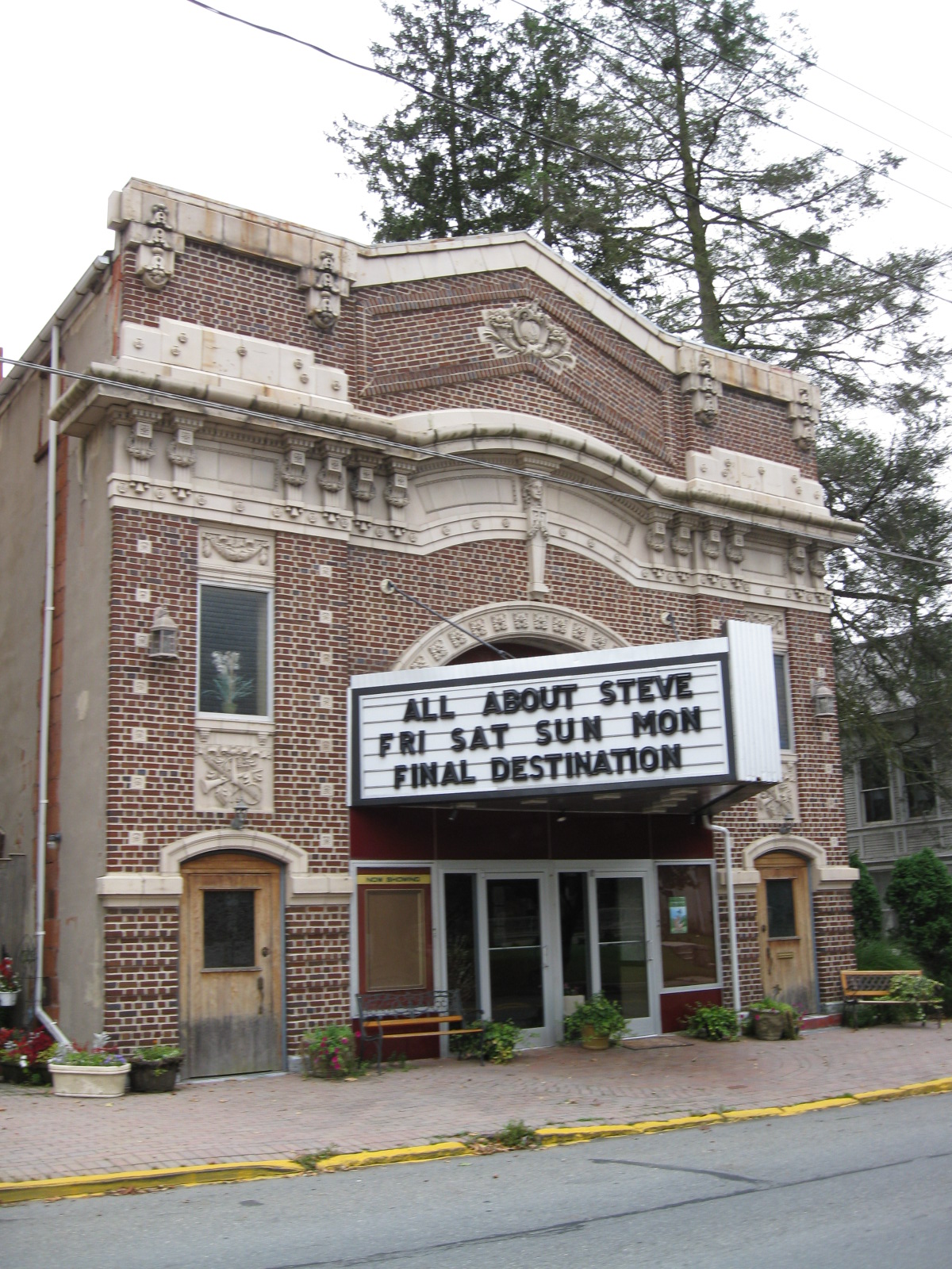


Pine Grove, Pennsylvania
Pine Grove is a borough of 2,118 people in Schuylkill County, Pennsylvania, founded in 1830.
Why visit Pine Grove
Townapedia lists 2 museums and landmarks, 2 parks and trails, 4 places to eat and 1 attraction in and around town.
Highlights include Schuylkill County Bridge No. 114, Nutting Hall and Pine Grove Historic District.
July is the warmest month, with average highs of 84°F; January lows average 22°F, and about 24 inches of snow fall in a normal year.
Weather in Pine Grove
Forecast from the National Weather Service. Full forecast
About Pine Grove
Pine Grove is a borough in Schuylkill County, Pennsylvania, United States. As of the 2020 census, the borough population was 2,054.
From the Wikipedia article Pine Grove, Schuylkill County, Pennsylvania (this version), under CC BY-SA 4.0.
Things to do1


Schuylkill County Bridge No. 114
Bridge · National Register of Historic Places · 3.2 mi
Museums and landmarks2

Nutting Hall
Monument and historic site · National Register of Historic Places · 0.5 mi
Building in Pennsylvania, United States
Pine Grove Historic District
Monument and historic site · National Register of Historic Places · 0.5 mi
Historic district in Pennsylvania, United States
Parks, trails and playgrounds2


Restaurants and cafes4

Brickyard Bistro LLC
Restaurant · Bistro, American
61 South Tulpehocken Street, Pine Grove
Mo-Sa 11:00-20:00; Su 11:00-19:00; Tu off
History
European settlement of the area by German Palatines, however, pre-dates this official founding date by at least several decades. Historical records document the Jacob Gunkle building was Lutheran church in the area as early as 1782.
The historic Nutting Hall was built between 1823 and 1825. Both Nutting Hall and the surrounding Pine Grove Historic District are listed on the National Register of Historic Places.
The 335-seat Pine Grove Theatre, which is also part of the Pine Grove Historic District, opened in 1910 and is still up and running {2021}.
From the History section of Pine Grove, Schuylkill County, Pennsylvania on Wikipedia, under CC BY-SA 4.0.
Churches and places of worship7
St. Paul's United Methodist Church
Church · United Methodist
19 East Pottsville Street, Pine Grove
Shopping3
Gas and EV charging2
Schools, colleges and libraries9
Healthcare2
Map of Pine Grove
32 places. The map loads OpenStreetMap tiles when you open it.
Climate by month
Monthly table
| Month | High | Low | Rain | Snow |
|---|---|---|---|---|
| Jan | 37°F | 22°F | 3.1 in | 6.8 in |
| Feb | 40°F | 23°F | 2.5 in | 7.8 in |
| Mar | 49°F | 31°F | 3.6 in | 4.2 in |
| Apr | 62°F | 40°F | 3.7 in | 0.4 in |
| May | 72°F | 51°F | 4.0 in | 0.0 in |
| Jun | 80°F | 60°F | 4.5 in | 0.0 in |
| Jul | 84°F | 64°F | 4.8 in | 0.0 in |
| Aug | 82°F | 63°F | 4.6 in | 0.0 in |
| Sep | 76°F | 55°F | 4.6 in | 0.0 in |
| Oct | 64°F | 44°F | 4.1 in | 0.3 in |
| Nov | 52°F | 34°F | 3.2 in | 0.5 in |
| Dec | 42°F | 27°F | 3.6 in | 4.0 in |
U.S. Climate Normals 1991-2020 for Lebanon 2 W Hcn (16 mi away), NOAA NCEI.
People and cost of living
American Community Survey 5-year estimates, 2020-2024, U.S. Census Bureau. Estimates have margins of error, larger for small towns.
Disaster history
Schuylkill County has had 14 federal disaster declarations since 2000, most often for severe storms.
- 2021-09-10: Remnants Of Hurricane Ida (Hurricane)
- 2020-03-30: Covid-19 Pandemic (Biological)
- 2020-03-13: Covid-19 (Biological)
- 2018-11-27: Severe Storms And Flooding (Severe Storm)
- 2016-03-23: Severe Winter Storm And Snowstorm (Snowstorm)
- 2012-10-29: Hurricane Sandy (Hurricane)
OpenFEMA disaster declarations summaries.
Getting there and nearby towns
Muir Army Airfield (Fort Indiantown Gap) Airport (MUI) is the nearest airport with scheduled flights listed in OpenStreetMap, 12 miles away.
- Fredericksburg 8 mi south, about 13 min by car
- Hegins 9 mi northwest, about 14 min by car
- Tower City 9 mi west, about 15 min by car
- Valley View 10 mi northwest, about 16 min by car
- Jonestown 11 mi southwest, about 18 min by car
- Cressona 11 mi northeast, about 18 min by car
- Minersville 12 mi northeast, about 19 min by car
- Pottsville 13 mi northeast, about 21 min by car
- Myerstown 13 mi south, about 21 min by car
- Lebanon 15 mi south, about 24 min by car
Drive times are estimates from straight-line distance, not routes.
Local news
Headlines from INDB, the NEMICO news database.
Reviews, tips and questions
Loading what members have shared...
Sources and licences
- NCES EDGE (Public domain): public schools
- NOAA NCEI U.S. Climate Normals 1991-2020 (Public domain): climate by month
- OpenFEMA (Public domain): disaster declarations
- OpenStreetMap contributors (ODbL 1.0): places, airports, map data
- U.S. Census Bureau (Public domain): population, income, housing, education, commute
- Wikidata (CC0 1.0): elevation, founding date, time zone, website, landmarks and historic places
- Wikimedia Commons (see each image): photos
- Wikipedia (CC BY-SA 4.0): overview and history text
Photo credits
- Pine Grove, Pennsylvania, Doug Kerr, CC BY-SA 2.0
- Pine Grove, Pennsylvania (4102030287), Doug Kerr from Albany, NY, United States, CC BY-SA 2.0
- Pine Grove, Pennsylvania (4102786684), Doug Kerr from Albany, NY, United States, CC BY-SA 2.0
- Pine Grove, Pennsylvania (4102786234), Doug Kerr from Albany, NY, United States, CC BY-SA 2.0
- Pine Grove, Pennsylvania (4102786374), Doug Kerr from Albany, NY, United States, CC BY-SA 2.0
- Pine Grove, Pennsylvania (4102030187), Doug Kerr from Albany, NY, United States, CC BY-SA 2.0
- Pine Grove, Pennsylvania (4102031053), Doug Kerr from Albany, NY, United States, CC BY-SA 2.0
- Pine Grove, Pennsylvania (4102030961), Doug Kerr from Albany, NY, United States, CC BY-SA 2.0
- Pine Grove, PA Keystone Marker 1, Doug Kerr from Albany, NY, United States, CC BY-SA 2.0
- Pine Grove, Pennsylvania (4102029539), Doug Kerr from Albany, NY, United States, CC BY-SA 2.0
- Pine Grove, Pennsylvania (4102786810), Doug Kerr from Albany, NY, United States, CC BY-SA 2.0
- Pine Grove, Pennsylvania (4102786156), Doug Kerr from Albany, NY, United States, CC BY-SA 2.0
- Pine Grove, Pennsylvania (4102787082), Doug Kerr from Albany, NY, United States, CC BY-SA 2.0
- Pine Grove, Pennsylvania (4102785676), Doug Kerr from Albany, NY, United States, Public domain
- Pine Grove Borough, PA Municipal Building, June 2025, Mr. Matté (if there is an issue with this image, contact me using this image's Commons talk page , my Commons user talk page , or my English Wikipedia user talk page ; I'll know about it a lot faster), CC BY-SA 4.0
- Pine Grove, PA post office, June 2025, Mr. Matté (if there is an issue with this image, contact me using this image's Commons talk page , my Commons user talk page , or my English Wikipedia user talk page ; I'll know about it a lot faster), CC BY-SA 4.0
- Pine Grove Area High School, Pine Grove, PA, July 2025, Mr. Matté (if there is an issue with this image, contact me using this image's Commons talk page , my Commons user talk page , or my English Wikipedia user talk page ; I'll know about it a lot faster), CC BY-SA 4.0
- St. Johns Lutheran Church, Pine Grove, PA, June 2025, Mr. Matté (if there is an issue with this image, contact me using this image's Commons talk page , my Commons user talk page , or my English Wikipedia user talk page ; I'll know about it a lot faster), CC BY-SA 4.0
- PA 895 wb approaching PA 443, Pine Grove, June 2025, Mr. Matté (if there is an issue with this image, contact me using this image's Commons talk page , my Commons user talk page , or my English Wikipedia user talk page ; I'll know about it a lot faster), CC BY-SA 4.0
- Canal Park tank, Pine Grove, PA, June 2025, Mr. Matté (if there is an issue with this image, contact me using this image's Commons talk page , my Commons user talk page , or my English Wikipedia user talk page ; I'll know about it a lot faster), CC BY-SA 4.0
- Pine Grove Homes Interior Side Walls Are Attached, Riverview Homes Inc, CC BY-SA 3.0
- Pine Grove Homes Home Is Built From The Frame Up, Riverview Homes Inc, CC BY-SA 3.0
- Pine Grove Homes Ready For Drywall, Riverview Homes Inc, CC BY-SA 3.0
- PA 895 wb entering Pine Grove Borough, June 2025, Mr. Matté (if there is an issue with this image, contact me using this image's Commons talk page , my Commons user talk page , or my English Wikipedia user talk page ; I'll know about it a lot faster), CC BY-SA 4.0
- Euklid Haul Truck, Pine Grove Twp, Schuylkill Co PA 01, Shuvaev, CC BY-SA 4.0
- Zimmerman's Covered Bridge, JERRYE & ROY KLOTZ MD, CC BY-SA 3.0
- PA 443 eb approaching PA 125, June 2025, Mr. Matté (if there is an issue with this image, contact me using this image's Commons talk page , my Commons user talk page , or my English Wikipedia user talk page ; I'll know about it a lot faster), CC BY-SA 4.0
- Manufactured Home Bulk Material Stored In Doors Ready For Production, Riverview Homes Inc, CC BY-SA 3.0
- Manufactured Home Roof Is Built And Lifted In Place, Riverview Homes Inc, CC BY-SA 3.0
- Manufactured Home Ready For Shippment To Your Site, Riverview Homes Inc, CC BY-SA 3.0
- Manufactured Home Side walls are built and attached, Riverview Homes Inc, CC BY-SA 3.0
- PA 443 wb in Pleasant Valley, Schuylkill County, July 2025, Mr. Matté (if there is an issue with this image, contact me using this image's Commons talk page , my Commons user talk page , or my English Wikipedia user talk page ; I'll know about it a lot faster), CC BY-SA 4.0


Page built October 30, 2026. Spotted a mistake? Tell us or suggest a place.