
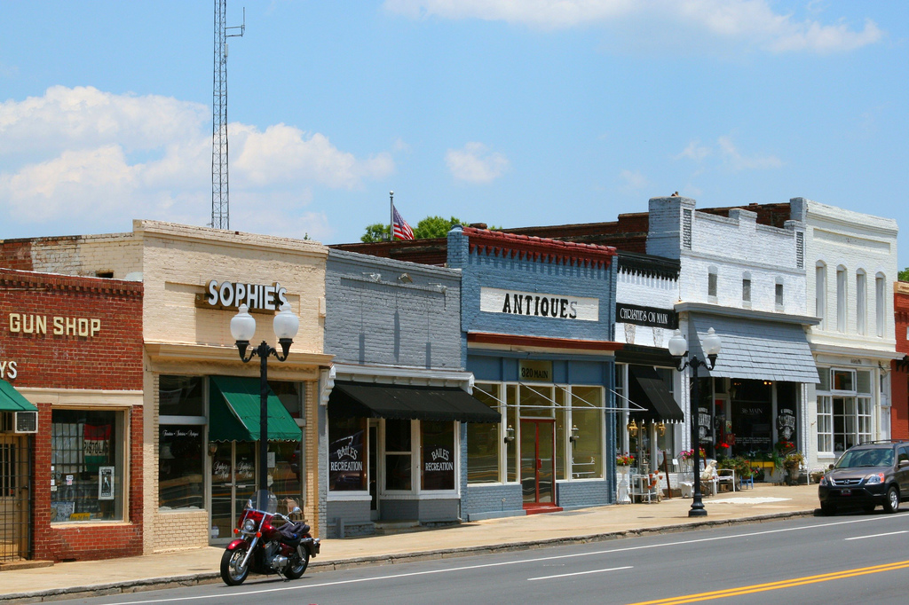

Pineville, North Carolina
Pineville is a town of 11,055 people in Mecklenburg County, North Carolina.
Why visit Pineville
Townapedia lists 5 museums and landmarks, 19 parks and trails, 110 places to eat, 12 places to stay and 3 attractions in and around town.
Highlights include AMC Carolina Pavilion 22, Carowinds, Pineville Commercial Historic District and Pineville Mill Village Historic District.
July is the warmest month, with average highs of 90°F; January lows average 32°F.
Weather in Pineville
Forecast from the National Weather Service. Full forecast
About Pineville
Pineville (; locally ) is a suburban town in the southernmost portion of Mecklenburg County, North Carolina, United States. Part of the Charlotte metropolitan area, it is situated in the Waxhaws region between Charlotte and Fort Mill. As of the 2020 census, Pineville had a population of 10,602, up from 7,479 in 2010.
From the Wikipedia article Pineville, North Carolina (this version), under CC BY-SA 4.0.
Things to do3


Carowinds
Monument and historic site · 3.0 mi
Amusement park in North and South Carolina

Museums and landmarks5
Pineville Commercial Historic District
Monument and historic site · National Register of Historic Places · 0.6 mi
Historic district in North Carolina, United States
Pineville Mill Village Historic District
Monument and historic site · National Register of Historic Places · 1.0 mi
Historic house in North Carolina, United States


Springfield Plantation House
Monument and historic site · National Register of Historic Places · 3.9 mi
Historic house in South Carolina, United States

President James K. Polk Historic Site
Museum · 1.1 mi
Historic site in Pineville, North Carolina
Parks, trails and playgrounds19

Anne Springs Close Greenway
Park · 4.2 mi
Park in Fort Mill, United States of America
Huntingtowne Farms Park
Park · 3.2 mi
Public park in Charlotte, North Carolina, United States
Park Road Park
Park · 4.2 mi
Urban park in Charlotte, North Carolina, USA

Sky Zone Trampoline Park
Sports field and stadium · 0.6 mi
10200 Centrum Parkway, Pineville

7 more on the map.
Restaurants and cafes110


Bombay Grille
Restaurant · Indian · 1.2 mi
8706 Pineville-Matthews Road, Charlotte
Mo-Th 11:00-14:30,17:00-21:30; Fr 11:00-14:30,17:00-22:30; Sa...
Chili's
Restaurant · Tex-Mex · 1.7 mi
8302 Pineville-Matthews Road, Pineville
Su-Th 11:00-23:00; Fr-Sa 11:00-00:00
Joy's Biryani N Kebabs
Restaurant · Indian · 0.4 mi
212 North Polk Street
Mo, We-Th 11:00-22:00; Fr 11:00-22:30; Sa 09:30-22:30; Su 09:30-22:00
Machu Picchu
Restaurant · Peruvian · 0.6 mi
123 Main Street, Pineville
Mo-Th 11:00-22:00; Fr 11:00-24:00; Sa 10:00-24:00; Su 10:00-22:00
Musashi Japanese Restaurant
Restaurant · Japanese · 1.6 mi
10110 Johnston Road
Mo 12:00-14:00, 17:30-21:30; We 17:30-21:30; Th 12:00-14:00,...
Nakato Japanese Steakhouse
Restaurant · Asian · 1.5 mi
8500 Pineville-Matthews Road, Charlotte
Mo-Th 17:00-21:00; Fr 17:00-22:00; Sa 16:00-22:00; Su 14:00-21:00
Olive Garden
Restaurant · Italian · 0.8 mi
9421 Pineville-Matthews Road, Pineville
Su-Th 11:00-22:00; Fr-Sa 11:00-23:00


Amelie's French Bakery and Cafe
Cafe · French, Coffee Shop, Bakery, Cake, Dessert · 2.1 mi
7715 Pineville-Matthews Road, Charlotte
Mo-Su 07:00-21:00
Chuck E. Cheese
Restaurant · Pizza · 2.2 mi
7701 Pineville-Matthews Road, Charlotte
Su-Th 11:00-21:00; Fr,Sa 10:00-22:00
98 more on the map.
History
Prior to its incorporation in 1873, Pineville, originally named Morrow's Turnout, was located at the intersection of two major Native American trading routes; it had vast meadows in which the animals of trade and transportation could be "turned-out" to pasture. The location served as a mule trading center in addition to a stop for stagecoaches and, later, the Charlotte & Columbia Railroad.
Around 1852, Morrow's Turnout was renamed Pineville, after the large stands of pine trees in the area.
The growth of Pineville was greatly changed through the initial segment of I-485 opening to traffic. Although the one-mile (1.6 km) stretch connecting interchanges at NC Highway 51 and South Boulevard was designed to divert through traffic around Charlotte via a freeway loop, I-485 incidentally passed through Pineville's town limits. In the years to follow, largely undeveloped land adjacent to Pineville's two I-485 interchanges developed into what is now the largest shopping district in North Carolina. The town population has grown from less than 2,000 between the 1930s and 1980s to over 10,000 in 2020.
From the History section of Pineville, North Carolina on Wikipedia, under CC BY-SA 4.0.
Where to stay12
Hampton Inn & Suites Charlotte/Pineville
Motel and hotel · 0.8 mi
401 Towne Centre Boulevard, Pineville
Extended Stay America
Motel and hotel · 1.6 mi
8405 Pineville-Matthews Road, Pineville
Four Points by Sheraton Charlotte - Pineville
Motel and hotel · 0.5 mi
9705 Leitner Drive, Pineville
Quality Suites Pineville - Charlotte
Motel and hotel · 0.6 mi
9840 Pineville-Matthews Road, Pineville
Suburban Extended Stay Hotel Charlotte-Ballantyne
Motel and hotel · 1.4 mi
10225 Feldfarm Lane, Charlotte
Churches and places of worship15
Flint Hill Baptist Church
Church · Baptist · 2.4 mi
269 Flint Hill Road, Fort Mill
Living Savior Lutheran Church
Church · Lutheran · 2.4 mi
6817 Carmel Road, Charlotte
Pineville United Methodist Church
Church · Methodist · 0.7 mi
110 South Polk Street, Pineville
Quail Hollow Presbyterian Church
Church · Presbyterian · 2.2 mi
8801 Park Road, Charlotte
Saint Mark AME Zion Church
Church · African Methodist Episcopal Zion · 0.9 mi
605 Johnston Drive, Pineville
Shopping41
Play It Again Sports
Shop · Seafood · 1.6 mi
8332 Pineville-Matthews Road, Charlotte
Gas and EV charging13
Schools, colleges and libraries47
Charlotte Catholic High School
School · Roman Catholic · 2.2 mi
7702 Pineville-Matthews Road, Charlotte
Charlotte-Mecklenburg Virtual School
School · 4.3 mi
7030 Nations Ford Road, Charlotte
Healthcare12
Passport Health Charlotte Travel Clinic
Clinic and pharmacy · 2.0 mi
10801 Johnston Road, Charlotte
Map of Pineville
250 places. The map loads OpenStreetMap tiles when you open it.
Climate by month
Monthly table
| Month | High | Low | Rain | Snow |
|---|---|---|---|---|
| Jan | 52°F | 32°F | 3.5 in | 1.6 in |
| Feb | 57°F | 35°F | 3.1 in | 1.1 in |
| Mar | 64°F | 41°F | 4.0 in | 0.3 in |
| Apr | 73°F | 49°F | 3.8 in | 0.0 in |
| May | 80°F | 58°F | 3.4 in | 0.0 in |
| Jun | 87°F | 66°F | 4.0 in | 0.0 in |
| Jul | 90°F | 70°F | 3.7 in | 0.0 in |
| Aug | 89°F | 69°F | 4.3 in | 0.0 in |
| Sep | 83°F | 63°F | 3.7 in | 0.0 in |
| Oct | 73°F | 50°F | 3.2 in | 0.0 in |
| Nov | 63°F | 40°F | 3.3 in | 0.1 in |
| Dec | 55°F | 34°F | 3.6 in | 0.4 in |
U.S. Climate Normals 1991-2020 for Charlotte Douglas Ap 72314 (10 mi away), NOAA NCEI.
People and cost of living
American Community Survey 5-year estimates, 2020-2024, U.S. Census Bureau. Estimates have margins of error, larger for small towns.
Disaster history
Mecklenburg County has had 14 federal disaster declarations since 2000, most often for hurricanes.
- 2026-01-24: Severe Winter Storm (Winter Storm)
- 2024-09-28: Tropical Storm Helene (Tropical Storm)
- 2024-09-26: Hurricane Helene (Tropical Storm)
- 2024-08-06: Tropical Storm Debby (Tropical Storm)
- 2022-10-01: Hurricane Ian (Hurricane)
- 2020-08-02: Hurricane Isaias (Hurricane)
OpenFEMA disaster declarations summaries.
Getting there and nearby towns
Charlotte-Douglas International Airport (CLT) is the nearest airport with scheduled flights listed in OpenStreetMap, 9 miles away.
- Charlotte 9 mi north, about 14 min by car
- Matthews 10 mi east, about 16 min by car
- Belmont 12 mi northwest, about 20 min by car
- Indian Trail 13 mi east, about 22 min by car
- Mint Hill 14 mi northeast, about 23 min by car
- Mount Holly 17 mi northwest, about 27 min by car
- Gastonia 20 mi northwest, about 32 min by car
- Monroe 20 mi east, about 32 min by car
- Harrisburg 20 mi northeast, about 32 min by car
- Huntersville 22 mi north, about 35 min by car
Drive times are estimates from straight-line distance, not routes.
Local news
Headlines from INDB, the NEMICO news database.
Reviews, tips and questions
Loading what members have shared...
Sources and licences
- NCES EDGE (Public domain): public schools
- NOAA NCEI U.S. Climate Normals 1991-2020 (Public domain): climate by month
- OpenFEMA (Public domain): disaster declarations
- OpenStreetMap contributors (ODbL 1.0): places, airports, map data
- U.S. Census Bureau (Public domain): population, income, housing, education, commute
- Wikidata (CC0 1.0): elevation, founding date, time zone, website, landmarks and historic places
- Wikimedia Commons (see each image): photos
- Wikipedia (CC BY-SA 4.0): overview and history text
Photo credits
- Main Street, Pineville NC, Deshort, CC BY-SA 3.0
- Springfield Plantation House, Bill Fitzpatrick, CC BY-SA 3.0
Page built October 30, 2026. Spotted a mistake? Tell us or suggest a place.