
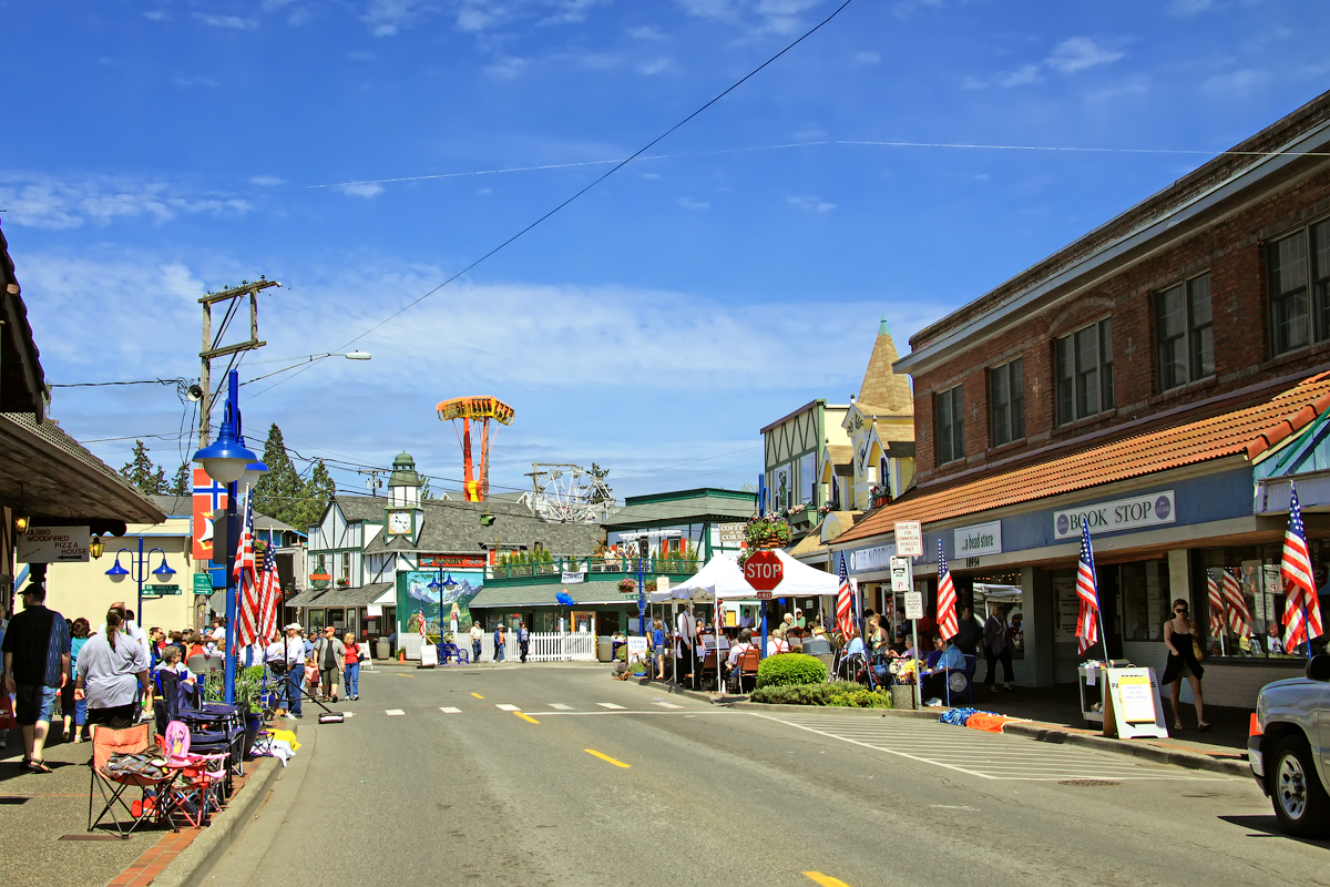


Poulsbo, Washington
Poulsbo is a city of 12,165 people in Kitsap County, Washington, founded in 1907.
Why visit Poulsbo
Townapedia lists 10 museums and landmarks, 18 parks and trails, 74 places to eat, 3 places to stay and 4 attractions in and around town.
Highlights include Regal Poulsbo, SEA Discovery Center, Agate Pass Bridge and Old Man House.
August is the warmest month, with average highs of 77°F; December lows average 35°F.
Weather in Poulsbo
Forecast from the National Weather Service. Full forecast
About Poulsbo
Poulsbo is a city on Liberty Bay in Kitsap County, Washington, United States. It is the smallest of the four cities in Kitsap County. The population was 11,970 at the 2020 census and an estimated 10,927 in 2018.
From the Wikipedia article Poulsbo, Washington (this version), under CC BY-SA 4.0.
Things to do4


SEA Discovery Center
Zoo and aquarium · 0.6 mi
18743 Front Street Northeast, Poulsbo
Fr,Sa 11:00-16:00

Museums and landmarks10

Agate Pass Bridge
Bridge · National Register of Historic Places · 4.1 mi
Structural steel truss cantilever bridge spanning Agate Pass, Washington state


Old Man House
Monument and historic site · National Register of Historic Places · 4.1 mi
Building in Washington, United States of America

Poulsbo Historical Society’s Research Center and Mini Museum
Museum · 0.4 mi
200 Northeast Moe Street, Poulsbo
Th 10:00-14:00 || "by appointment"
Suquamish Museum
Museum · 3.7 mi
Tribal museum in Suquamish, Washington

Parks, trails and playgrounds18

Port of Poulsbo Marina
Marina and boat launch · 0.7 mi
18809 Front Street Northeast, Poulsbo
Mo-Fr 08:00-16:30; Sa-Su off; Jan 01 off; Nov Th[4] off; Dec 25-26 off

Fish Park
Park · 0.7 mi
Fish Park is a 41.3 acre park on the Liberty Bay Estuary and Dogfish Creek. It contains 1.75 miles of trails, boardwalk and viewing platforms.
288 Northwest Lindvig Way, Poulsbo
Lions Park
Park · 0.9 mi
Lions' Park is a 1.2 acre park at the corner of 6th Avenue and Fjord Drive in Poulsbo. It contains picnic areas, restrooms, courts for...
18120 Fjord Drive Northeast, Poulsbo
Muriel Iverson Williams Waterfront Park
Park · 0.5 mi
Waterfront park along the Port of Poulsbo Marina with views of Liberty Bay. Amenities include bathrooms, a pavilion (available for...
18809 Anderson Parkway, Poulsbo
Net Shed Park
Park · 0.7 mi
Net Shed Vista is a .69 acre viewing area overlooking Liberty Bay, containing picnic tables and benches.
18500 Fjord Drive Northeast, Poulsbo
6 more on the map.
Restaurants and cafes74

Hot Shots Java
Cafe · Coffee Shop · 0.5 mi
Hot Shots Java is a family owned and operated coffeehouse located in historic downtown Poulsbo.
18881 Front Street Northeast, Poulsbo
Mo-Su 07:00-17:00

Juicy J's Smoked Burgers
Restaurant · Burger, American · 0.6 mi
18779 Anderson Parkway, Poulsbo
Tu-Sa 11:00-20:00; Su 11:00-19:00
Poulsbo Wood Fired Pizza
Restaurant · Pizza · 0.5 mi
18937 Front Street Northeast, Poulsbo
Tu-Su 11:00-20:00
The Loft
Restaurant · Regional · 0.6 mi
18779 Front Street Northeast, Poulsbo
Mo-Th 11:30-21:00; Fr,Sa 11:30-22:00; Su 11:30-20:00

Tizley's Europub
Bar and pub · European · 0.5 mi
18928 Front Street Northeast, Poulsbo
Mo-Su 11:00-20:00

New Leaf Pho
Restaurant · Vietnamese · 0.8 mi
20530 Viking Avenue Northwest, Poulsbo
Mo-Fr 11:00-21:00, Sa-Su 12:00-21:00

Westside Pizza
Restaurant · Pizza, Wings, Salad, Pasta, Dessert · 0.5 mi
18960 State Highway 305 Northeast, Poulsbo
Mo-Th,Su 11:00-20:00; Fr-Sa 11:00-21:00
62 more on the map.
History
The Suquamish people have inhabited Liberty Bay for millennia, hunting in local forests and floodplains, fishing in bays and streams, and harvesting shellfish along the shoreline. The site upon which the modern city is built is called č̓uʔč̓uɬac, meaning "maple trees". The Suquamish had a winter village nearby, at the head of Liberty Bay, anglicized variously as "Ho-Cheeb" and "Xoyacid," which consisted of two large houses and four smaller houses. It existed until the late 1800s when settlers began populating the area.
After the signing of the Treaty of Point Elliott in 1855, most of the Suquamish people living in the area were relocated to the Port Madison Indian Reservation.
Founded by Norwegian immigrant Jørgen Eliason in the 1880s, Poulsbo was settled in its early years by a large number of Norwegian and other Scandinavian immigrants because of its similarities to their native countries. In 1886, Iver Brynildsen Moe, one of the early Norwegian settlers, suggested that the community should have a post office. Moe suggested the town be named "Paulsbo", his hometown in Halden, Norway. The community's petition for a post office was granted and Moe became the first postmaster, but authorities in Washington, D.C. misspelled the town's name, likely misreading Moe's handwriting, and the community became known as "Poulsbo" thereafter. Poulsbo was incorporated on December 18, 1907.
From the History section of Poulsbo, Washington on Wikipedia, under CC BY-SA 4.0.
Where to stay3
Fairfield Inn & Suites Seattle Poulsbo
Motel and hotel · 1.8 mi
22022 Quickstep Court Northwest, Poulsbo
GuestHouse Inn & Suites - Poulsbo
Motel and hotel
19801 7th Avenue Northeast, Poulsbo
Churches and places of worship10
Faith Episcopal Church
Church · Episcopal · 0.5 mi
20295 Little Valley Road Northeast, Poulsbo
North Kitsap Baptist Church
Church · Baptist · 0.6 mi
20516 Little Valley Road Northeast, Poulsbo
Shopping20
Gas and EV charging6
Schools, colleges and libraries18
Clear Creek Elementary School
School · 4.8 mi
12901 Winter Creek Ave Nw, Silverdale
Healthcare5
Cascade Specialty Pharmacy
Clinic and pharmacy · 0.6 mi
325 Northeast Hostmark Street
Map of Poulsbo
168 places. The map loads OpenStreetMap tiles when you open it.
Climate by month
Monthly table
| Month | High | Low | Rain | Snow |
|---|---|---|---|---|
| Jan | 47°F | 36°F | 9.3 in | 0.6 in |
| Feb | 49°F | 35°F | 5.8 in | 0.7 in |
| Mar | 54°F | 38°F | 6.4 in | 0.1 in |
| Apr | 59°F | 41°F | 3.9 in | 0.0 in |
| May | 66°F | 46°F | 2.4 in | 0.0 in |
| Jun | 70°F | 51°F | 1.6 in | 0.0 in |
| Jul | 76°F | 55°F | 0.8 in | 0.0 in |
| Aug | 77°F | 55°F | 1.1 in | 0.0 in |
| Sep | 72°F | 51°F | 1.8 in | 0.0 in |
| Oct | 61°F | 45°F | 5.1 in | 0.0 in |
| Nov | 51°F | 39°F | 8.8 in | 0.3 in |
| Dec | 46°F | 35°F | 9.9 in | 1.3 in |
U.S. Climate Normals 1991-2020 for Bremerton (12 mi away), NOAA NCEI.
People and cost of living
American Community Survey 5-year estimates, 2020-2024, U.S. Census Bureau. Estimates have margins of error, larger for small towns.
Disaster history
Kitsap County has had 7 federal disaster declarations since 2000, most often for severe storms.
- 2020-03-22: Covid-19 Pandemic (Biological)
- 2020-03-13: Covid-19 (Biological)
- 2007-12-08: Severe Storms, Flooding, Landslides, And Mudslides (Severe Storm)
- 2006-05-17: Severe Storms, Flooding, Tidal Surge, Landslides, And Mudslides (Severe Storm)
- 2005-09-07: Hurricane Katrina Evacuation (Coastal Storm)
- 2003-11-07: Severe Storms And Flooding (Severe Storm)
OpenFEMA disaster declarations summaries.
Getting there and nearby towns
Port of Poulsbo Marina Moorage Seaplane Base (PUL) is the nearest airport with scheduled flights listed in OpenStreetMap, 1 miles away.
- Bainbridge Island 9 mi southeast, about 15 min by car
- Bremerton 14 mi south, about 23 min by car
- Edmonds 14 mi east, about 23 min by car
- Seattle 16 mi southeast, about 26 min by car
- Mountlake Terrace 16 mi east, about 26 min by car
- Lake Forest Park 16 mi east, about 26 min by car
- Lynnwood 17 mi east, about 27 min by car
- Kenmore 18 mi east, about 30 min by car
- North Lynnwood 19 mi northeast, about 30 min by car
- Kirkland 21 mi east, about 33 min by car
Drive times are estimates from straight-line distance, not routes.
Local news
Headlines from INDB, the NEMICO news database.
Reviews, tips and questions
Loading what members have shared...
Sources and licences
- NCES EDGE (Public domain): public schools
- NOAA NCEI U.S. Climate Normals 1991-2020 (Public domain): climate by month
- OpenFEMA (Public domain): disaster declarations
- OpenStreetMap contributors (ODbL 1.0): places, airports, map data
- U.S. Census Bureau (Public domain): population, income, housing, education, commute
- Wikidata (CC0 1.0): elevation, founding date, time zone, website, landmarks and historic places
- Wikimedia Commons (see each image): photos
- Wikipedia (CC BY-SA 4.0): overview and history text
Photo credits
- Front Street NE, Poulsbo, Washington, Steven Pavlov, CC BY-SA 3.0
- Poulsbo, WA 98370, USA - panoramio (14), nick hoke, CC BY 3.0
- Poulsbo Place after snowfall - panoramio, nick hoke, CC BY 3.0
- Jensen Way - Poulsbo Place - panoramio, nick hoke, CC BY 3.0
- Poulsbo Place - panoramio, nick hoke, CC BY 3.0
- Poulsbo - panoramio (25), nick hoke, CC BY 3.0
- Fall colors in Poulsbo - panoramio (1), nick hoke, CC BY 3.0
- Winter Snow on Toon Town, Poulsbo, looking West - panoramio, nick hoke, CC BY 3.0
- Poulsbo - panoramio, nick hoke, CC BY 3.0
- Poulsbo Rainbow - panoramio, nick hoke, CC BY 3.0
- Poulsbo, Sunset Street - panoramio, nick hoke, CC BY 3.0
- Poulsbo - colorful houses under a blanket of snow - panoramio, nick hoke, CC BY 3.0
- Poulsbo - panoramio (24), nick hoke, CC BY 3.0
- Poulsbo (5536188061), InSapphoWeTrust from Los Angeles, California, USA, CC BY-SA 2.0
- Poulsbo Library, Steven Pavlov, CC BY-SA 3.0
- Poulsbo City Hall, Steven Pavlov, CC BY-SA 3.0
- 2025-03-22, Poulsbo Heritage Museum, 131840(N), Nadine Pavlov, CC BY-SA 4.0
- Old Man House 2 NRHP 89002299 Kitsap County, WA, Jon Roanhaus, CC BY-SA 3.0
- Agate pass1, User:DVD R W, CC BY-SA 3.0
- Multi colored houses under a new blanket of snow - panoramio, nick hoke, CC BY 3.0
- Jensen Way near downtown, in the snow - panoramio, nick hoke, CC BY 3.0
- Skittles houses with snowy roofs - panoramio, nick hoke, CC BY 3.0
- Foggy Morning over Toon Town - panoramio, nick hoke, CC BY 3.0
- The other snow fall this winter - panoramio, nick hoke, CC BY 3.0
- A temporary street flooding - panoramio, nick hoke, CC BY 3.0
- Storm drains clogged - heavy rain on 7th avenue = flooding - panoramio, nick hoke, CC BY 3.0
- Fall Colors - panoramio (5), nick hoke, CC BY 3.0
- PFD Station 71 @ 911 Liberty Rd - panoramio, nick hoke, CC BY 3.0
- Red one - panoramio, nick hoke, CC BY 3.0
- Green one - panoramio, nick hoke, CC BY 3.0
- Sunset Street in February - panoramio, nick hoke, CC BY 3.0
- Sunset Street in January - panoramio, nick hoke, CC BY 3.0
- Tiny cottage - panoramio (1), nick hoke, CC BY 3.0
- North Kitsap High School aerial looking east, Tedder, CC BY 4.0
- Liberty bay, reflection with clouds - panoramio, nick hoke, CC BY 3.0
- Fall colors in glass - panoramio, nick hoke, CC BY 3.0
- Horse and Fence (Unsplash), Chance Anderson chanceanderson, CC0
- Front street - panoramio, nick hoke, CC BY 3.0
- Gran Kirk (big church) building on Front Street - panoramio, nick hoke, CC BY 3.0
- First Lutheran Church cemetary - panoramio, nick hoke, CC BY 3.0


Page built October 30, 2026. Spotted a mistake? Tell us or suggest a place.