


Prairie du Chien, Wisconsin
Prairie du Chien is a city of 5,491 people in Crawford County, Wisconsin, founded in 1673.
Why visit Prairie du Chien
Townapedia lists 31 museums and landmarks, 22 parks and trails, 16 places to eat, 13 places to stay and 3 attractions in and around town.
Highlights include Pile–Pontoon Railroad Bridge, Prairie Cinema, Villa Louis and Prairie du Chien City Hall.
July is the warmest month, with average highs of 83°F; January lows average 10°F, and about 34 inches of snow fall in a normal year.
Weather in Prairie du Chien
Forecast from the National Weather Service. Full forecast
About Prairie du Chien
Prairie du Chien ( PRAIR-ee doo SHEEN) is a city in Crawford County, Wisconsin, United States, and its county seat. The population was 5,506 at the 2020 census. Often called Wisconsin's second-oldest city, Prairie du Chien was established as a European settlement by French voyageurs in the late 17th century. Its settlement date of June 17, 1673, makes it the fourth colonial settlement by European settlers in the Midwestern United States, after Green Bay, Wisconsin; Sault Ste.
From the Wikipedia article Prairie du Chien, Wisconsin (this version), under CC BY-SA 4.0.
Things to do3

Pile–Pontoon Railroad Bridge
Bridge · 2.0 mi
Former railroad bridge over the Mississippi River between Iowa and Wisconsin


Museums and landmarks31

Villa Louis
Monument and historic site · National Register of Historic Places · 1.6 mi
Mansion in Wisconsin, USA
521 North Villa Louis Road, Prairie du Chien

Prairie du Chien City Hall
Monument and historic site · National Register of Historic Places · 0.9 mi
City hall in Wisconsin, United States of America

American House
Monument and historic site · National Register of Historic Places · 2.2 mi
Historic building located in McGregor, Iowa, United States

American School of Wild Life Protection Historic District
Monument and historic site · National Register of Historic Places · 2.2 mi
United States historic place

Astor Fur Warehouse
Monument and historic site · National Register of Historic Places · 1.6 mi
Historic building in Prairie du Chien, Wisconsin, USA

Brisbois House
Monument and historic site · National Register of Historic Places · 1.5 mi
Historic house located on St. Feriole Island in Prairie du Chien, Wisconsin

Christian Bloedel Wagon Works
Monument and historic site · National Register of Historic Places · 2.7 mi
Building in Iowa, United States

Commercial Hotel
Monument and historic site · National Register of Historic Places · 0.9 mi
Hotel building in Prairie du Chien, Wisconsin
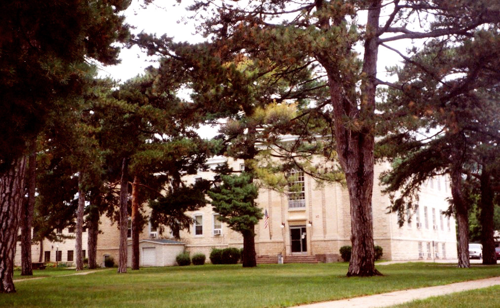
Crawford County Courthouse
Monument and historic site · National Register of Historic Places · 1.0 mi
Building in Prairie du Chien, Wisconsin, United States

Dousman Hotel
Monument and historic site · National Register of Historic Places · 1.5 mi
Historic hotel located at the intersection of Fisher Street and River Road in Prairie du Chien, Wisconsin

Effigy Mounds National Monument
Monument and historic site · National Register of Historic Places · 4.1 mi
National monument of prehistoric mounds built by Native Americans, in Iowa, United States


Fort Crawford
Museum · National Register of Historic Places · 0.6 mi
19th century military outpost of the United States Army located in Prairie du Chien, Wisconsin
19 more on the map.
Parks, trails and playgrounds22

Limery Ridge Savanna State Natural Area
Park · 2.7 mi
Park in the United States of America

St. Feriole Island Riverfront Playground
Playground · 1.5 mi
North Water Street, Prairie du Chien
10 more on the map.
Restaurants and cafes16




4 more on the map.
History
The first known Europeans to reach Prairie du Chien were French explorers Jacques Marquette and Louis Joliet, who arrived by canoe on June 17, 1673, discovering a route to the Mississippi River. Later travel between Canada and the Mississippi River continued to pass through Prairie du Chien, although routes via the Illinois River were also used. In 1685, the French explorer Nicolas Perrot established a trading post in the area as part of the large and lucrative French fur trade industry. After John Jacob Astor's machinations had closed the entire government fur trade factory system and the federal factory established in Prairie du Chien in 1815, the American Fur Company became established in the area and later built the Astor Fur Warehouse, an important building in the regional fur trade, which was centered in Prairie du Chien. Prairie du Chien's significance as a center of the fur trade did not diminish until the mid-19th century, when European demand declined, as did game stock.
From the History section of Prairie du Chien, Wisconsin on Wikipedia, under CC BY-SA 4.0.
Where to stay13
Microtel Inn & Suites
Motel and hotel · 0.8 mi
1833 South Marquette Road, Prairie du Chien
Churches and places of worship3
Shopping8
Gas and EV charging8
Schools, colleges and libraries12
Mighty River Academy of Virtual Education
School
800 E Crawford St, Prairie Du Chien
Prairie Du Chien Correctional Inst
School · 0.7 mi
500 E Parrish St, Prairie Du Chien
Healthcare3
Map of Prairie du Chien
119 places. The map loads OpenStreetMap tiles when you open it.
Climate by month
Monthly table
| Month | High | Low | Rain | Snow |
|---|---|---|---|---|
| Jan | 27°F | 10°F | 1.2 in | 9.0 in |
| Feb | 32°F | 13°F | 1.3 in | 8.6 in |
| Mar | 45°F | 25°F | 2.0 in | 4.3 in |
| Apr | 59°F | 37°F | 4.0 in | 1.4 in |
| May | 70°F | 48°F | 4.7 in | 0.0 in |
| Jun | 80°F | 59°F | 5.8 in | 0.0 in |
| Jul | 83°F | 63°F | 4.1 in | 0.0 in |
| Aug | 81°F | 61°F | 4.2 in | 0.0 in |
| Sep | 74°F | 52°F | 4.0 in | 0.0 in |
| Oct | 62°F | 40°F | 2.7 in | 0.2 in |
| Nov | 46°F | 28°F | 2.1 in | 1.5 in |
| Dec | 33°F | 17°F | 1.6 in | 8.8 in |
U.S. Climate Normals 1991-2020 for Prairie Du Chien Hcn (1 mi away), NOAA NCEI.
People and cost of living
American Community Survey 5-year estimates, 2020-2024, U.S. Census Bureau. Estimates have margins of error, larger for small towns.
Disaster history
Crawford County has had 12 federal disaster declarations since 2000, most often for severe storms.
- 2020-04-04: Covid-19 Pandemic (Biological)
- 2020-03-13: Covid-19 (Biological)
- 2018-10-18: Severe Storms, Tornadoes, Straight-Line Winds, Flooding, And Landslides (Flood)
- 2017-10-07: Severe Storms, Straight-Line Winds, Flooding, Landslides, And Mud (Severe Storm)
- 2016-10-20: Severe Storms, Flooding, And Mudslides (Flood)
- 2013-08-08: Severe Storms, Flooding, And Mudslides (Severe Storm)
OpenFEMA disaster declarations summaries.
Getting there and nearby towns
Prairie Du Chien Municipal Airport (PCD) is the nearest airport with scheduled flights listed in OpenStreetMap, 2 miles away.
- Guttenberg 18 mi south, about 28 min by car
- Elkader 19 mi southwest, about 30 min by car
- Postville 22 mi west, about 35 min by car
- Lansing 22 mi north, about 36 min by car
- Boscobel 23 mi east, about 37 min by car
- Waukon 23 mi northwest, about 38 min by car
- Fennimore 25 mi east, about 40 min by car
- Lancaster 26 mi southeast, about 41 min by car
- Strawberry Point 32 mi southwest, about 52 min by car
- West Union 35 mi west, about 56 min by car
Drive times are estimates from straight-line distance, not routes.
Local news
Headlines from INDB, the NEMICO news database.
Reviews, tips and questions
Loading what members have shared...
Sources and licences
- NCES EDGE (Public domain): public schools
- NOAA NCEI U.S. Climate Normals 1991-2020 (Public domain): climate by month
- OpenFEMA (Public domain): disaster declarations
- OpenStreetMap contributors (ODbL 1.0): places, airports, map data
- U.S. Census Bureau (Public domain): population, income, housing, education, commute
- Wikidata (CC0 1.0): elevation, founding date, time zone, website, landmarks and historic places
- Wikimedia Commons (see each image): photos
- Wikipedia (CC BY-SA 4.0): overview and history text
Photo credits
- Prairie du Chien skyline, Wikideas1, CC0
- VillaLouisMansion, Jonathunder, CC BY-SA 3.0
- The Prairie du Chien City Hall, Boscophotos, CC BY-SA 3.0
- Prairie du Chien Post Office, Jonathunder, CC BY-SA 3.0
- Effigy-Mounds-Great-Bear, National Park Service, Public domain
- The Goedert Meat Market, Jim Roberts, CC BY-SA 4.0
- FortCrawfordMuseum, Jonathunder, CC BY-SA 3.0
- Commercial Hotel Prairie du Chien, Jeff the quiet, CC0
- AstorFurWarehouse, Jonathunder, CC BY-SA 3.0
- Vertefeuille, Jonathunder, CC BY-SA 3.0
- The Strange-Powers House, Boscophotos, CC BY-SA 3.0
- OldRockSchool, Jonathunder, CC BY-SA 3.0
- BrisboisHouse, Jonathunder, CC BY-SA 3.0
- The Joseph Reynolds Office Building and House, Jim Roberts, CC BY-SA 4.0
- RoletteHouse, Jonathunder, CC BY-SA 3.0
- DousmanHotel, Jonathunder, CC BY-SA 3.0
- The Peter Stauer House, Jim Roberts, CC BY-SA 4.0
- W H C Folsom House, Jeff the quiet, CC0
- The American House, Jim Roberts, CC BY-SA 4.0
- McGregor Iowa, w:Flickr user LHOON, CC BY-SA 2.0
- Wyalusing Academy - panoramio (8), JD Milburn, CC BY 3.0
- St. Germain dit Gauthier House, TheCatalyst31, CC0
- The Christian Bloedel Wagon Works, Jim Roberts, CC BY-SA 4.0
- CrawfordCountyWisconsinCourtHouse, Jimmy Emerson, CC BY-SA 2.0
- Old Pontoon Bridge North McGregor Iowa 1885, Henry Peter Bosse, Public domain


Page built October 30, 2026. Spotted a mistake? Tell us or suggest a place.