


Richmond, California
Richmond is a city of 115,505 people in Contra Costa County, California, founded in 1905.
Why visit Richmond
Townapedia lists 27 museums and landmarks, 104 parks and trails, 82 places to eat, 8 places to stay and 16 attractions in and around town.
Highlights include East Brother Island Light, Masquers Playhouse, Golden State Model Railroad Museum and Ford Motor Company Assembly Plant.
September is the warmest month, with average highs of 75°F; January lows average 44°F.
Weather in Richmond
Forecast from the National Weather Service. Full forecast
About Richmond
Richmond is a city in western Contra Costa County, California, United States. The city was incorporated on August 3, 1905, and has a city council. Located in the San Francisco Bay Area's East Bay region, Richmond borders San Pablo, Albany, El Cerrito and Pinole in addition to the unincorporated communities of North Richmond, Hasford Heights, Kensington, El Sobrante, Bayview-Montalvin Manor, Tara Hills, and East Richmond Heights, and for a short distance San Francisco on Red Rock Island in the San Francisco Bay.
From the Wikipedia article Richmond, California (this version), under CC BY-SA 4.0.
Things to do16

East Brother Island Light
Lighthouse · National Register of Historic Places · 4.0 mi
Lighthouse in California, United States



Richmond–San Rafael Bridge
Bridge · 4.9 mi
Bridge crossing the San Francisco Bay in Marin and Contra Costa counties in California, United States

Southampton Shoal Light
Lighthouse · 5.3 mi
Former lighthouse site in California, United States
East Bay Center for the Performing Arts
Cinema and theater · 1.1 mi
1029 Macdonald Avenue, Richmond

4 more on the map.
Museums and landmarks27
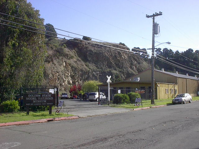
Golden State Model Railroad Museum
Museum · 2.8 mi
Model railroad museum in Point Richmond, California
900-A Dornan Drive, PT RICHMOND
We 11:00-15:00; Sa,Su 12:00-17:00

Ford Motor Company Assembly Plant
Monument and historic site · National Register of Historic Places · 2.9 mi
Assembly plant in Richmond, California, United States

Nystrom Elementary School
Monument and historic site · National Register of Historic Places · 1.7 mi
Historic building in Richmond, California, United States
Atchison Village
Monument and historic site · National Register of Historic Places · 1.4 mi
Neighbourhood in Richmond, California, United States of America

Bank of Pinole
Monument and historic site · National Register of Historic Places · 5.3 mi
Historic building in Pinole, California, United States

Bernardo Fernandez House
Monument and historic site · National Register of Historic Places · 5.4 mi
Historic house in California, United States

Donald and Helen Olsen House
Monument and historic site · National Register of Historic Places · 6.2 mi
Historic house in California, United States
New Hotel Carquinez
Monument and historic site · National Register of Historic Places · 1.0 mi
Hotel in California, United States of America
Point Richmond Historic District
Monument and historic site · National Register of Historic Places · 2.3 mi
Hidtyoric district in Richmond, California

Rosie the Riveter Visitor Center
Museum · 2.9 mi
Mo-Su 10:00-17:00; Jan 1 off; Dec 25 off; Thanksgiving off

Winehaven
Monument and historic site · National Register of Historic Places · 3.1 mi
Human settlement in California, United States of America
15 more on the map.
Parks, trails and playgrounds104

Alvarado Area
Park · National Register of Historic Places · 2.6 mi
National Historic Place in Richmond, California



Rosie the Riveter World War II Home Front National Historical Park
Park · National Register of Historic Places · 3.0 mi
U.S. national park in California
Keller Beach
Park · 2.6 mi
Park in California, United States of America

Point Molate Beach Park
Park · 2.8 mi
Park in Richmond, California, U.S.
Richmond Country Club
Park · 2.6 mi
Park in California, United States of America
Albany Mudflats Ecological Reserve
Park · 4.9 mi
Ecological reserve in San Francisco, California
92 more on the map.
Restaurants and cafes82

Brazilian House & Restaurant Goiano
Restaurant · Brazilian · 2.3 mi
12221 Ste #2 San Pablo Avenue
Mo-Sa 06:00-16:00; Su 07:00-16:00
El Garage
Restaurant · Mexican · 1.2 mi
1428 Macdonald Avenue, Richmond
We-Sa 10:00-21:00; Su 10:00-18:00
Golden Gate Bistro Restaurant
Restaurant · American, Burger, Bistro · 2.1 mi
803 Ste #101 Wright Avenue, Richmond
Mo-Fr 06:00-17:00; Sa 08:00-17:00; Su 08:00-15:00
H&Js
Restaurant · American, Breakfast, Brunch · 3.8 mi
10841 San Pablo Avenue, El Cerrito
We-Su 08:30-14:00
Kitchen
Restaurant · Burger, Italian, Seafood, Fish And Chips · 3.3 mi
1900 Stenmark Drive, Richmond
Mo-Su 11:00-19:00
70 more on the map.
History
The Ohlone were the first inhabitants of the Richmond area, settling an estimated 5,000 years ago. They spoke the Chochenyo language, and subsisted as hunter-gatherers and harvesters.
From the History section of Richmond, California on Wikipedia, under CC BY-SA 4.0.
Where to stay8
Churches and places of worship85
Antioch Missionary Baptist Church
Church · Baptist · 1.8 mi
380 South 17th Street, Richmond
Bethel Temple Pentecostal Church
Church · Pentecostal · 2.3 mi
3429 Cutting Boulevard, Richmond
Calvary Missionary Baptist Church
Church · Baptist · 1.0 mi
443 4th Street, Richmond
Easter Hill United Methodist Church
Church · Methodist · 2.4 mi
3911 Cutting Boulevard, Richmond
First Church of Christ Scientist
Church · Christ Scientist · 1.3 mi
2417 Barrett Avenue, Richmond
Greater El Bethel Missionary Baptist Church
Church · Baptist · 2.2 mi
813 Williams Drive
Mount Olive Missionary Baptist Church
Church · Baptist · 2.0 mi
2404 Cutting Boulevard, Richmond
Shopping14
Gas and EV charging21
Schools, colleges and libraries93
Richmond Public Library - Bayview Branch
Library · 3.3 mi
5100 Hartnett Avenue, Richmond
Richmond Public Liibrary - Main Library
Library · 1.4 mi
325 Civic Center Plaza, Richmond
Aspire Richmond Ca. College Preparatory Academy
School · 2.5 mi
3040 Hilltop Mall Rd., Richmond
Healthcare6
Native American Health Center
Clinic and pharmacy · 1.5 mi
2566 Macdonald Avenue, Richmond
Map of Richmond
250 places. The map loads OpenStreetMap tiles when you open it.
Climate by month
Monthly table
| Month | High | Low | Rain | Snow |
|---|---|---|---|---|
| Jan | 58°F | 44°F | 4.8 in | 0.0 in |
| Feb | 61°F | 46°F | 4.8 in | 0.0 in |
| Mar | 64°F | 47°F | 3.2 in | 0.0 in |
| Apr | 67°F | 49°F | 1.6 in | 0.0 in |
| May | 69°F | 52°F | 0.7 in | 0.0 in |
| Jun | 72°F | 54°F | 0.3 in | 0.0 in |
| Jul | 71°F | 55°F | 0.0 in | 0.0 in |
| Aug | 72°F | 56°F | 0.1 in | 0.0 in |
| Sep | 75°F | 56°F | 0.0 in | 0.0 in |
| Oct | 73°F | 54°F | 1.4 in | 0.0 in |
| Nov | 65°F | 49°F | 2.7 in | 0.0 in |
| Dec | 58°F | 44°F | 4.9 in | 0.0 in |
U.S. Climate Normals 1991-2020 for Richmond (2 mi away), NOAA NCEI.
People and cost of living
American Community Survey 5-year estimates, 2020-2024, U.S. Census Bureau. Estimates have margins of error, larger for small towns.
Disaster history
Contra Costa County has had 9 federal disaster declarations since 2000, most often for floods.
- 2023-01-14: Severe Winter Storms, Flooding, Landslides, And Mudslides (Flood)
- 2023-01-09: Severe Winter Storms, Flooding, And Mudslides (Flood)
- 2020-03-22: Covid-19 Pandemic (Biological)
- 2020-03-13: Covid-19 (Biological)
- 2017-04-01: Severe Winter Storms, Flooding, And Mudslides (Flood)
- 2017-03-16: Severe Winter Storms, Flooding, And Mudslides (Flood)
OpenFEMA disaster declarations summaries.
Getting there and nearby towns
San Rafael Airport (SRF) is the nearest airport with scheduled flights listed in OpenStreetMap, 10 miles away.
- San Pablo 1 mi northeast, about 2 min by car
- El Sobrante 3 mi northeast, about 6 min by car
- El Cerrito 4 mi southeast, about 6 min by car
- Pinole 5 mi northeast, about 8 min by car
- Albany 5 mi southeast, about 8 min by car
- Hercules 6 mi northeast, about 10 min by car
- Berkeley 7 mi southeast, about 11 min by car
- San Rafael 8 mi west, about 13 min by car
- Corte Madera 8 mi west, about 13 min by car
- Emeryville 8 mi south, about 14 min by car
Drive times are estimates from straight-line distance, not routes.
Local news
Headlines from INDB, the NEMICO news database.
Reviews, tips and questions
Loading what members have shared...
Sources and licences
- NCES EDGE (Public domain): public schools
- NOAA NCEI U.S. Climate Normals 1991-2020 (Public domain): climate by month
- OpenFEMA (Public domain): disaster declarations
- OpenStreetMap contributors (ODbL 1.0): places, airports, map data
- U.S. Census Bureau (Public domain): population, income, housing, education, commute
- Wikidata (CC0 1.0): elevation, founding date, time zone, website, landmarks and historic places
- Wikimedia Commons (see each image): photos
- Wikipedia (CC BY-SA 4.0): overview and history text
Photo credits
- Richmond California aerial view with bridge, U.S. Army Corps of Engineers, photographer not specified or unknown, Public domain
- Race and ethnicity 2020 Richmond, CA, CensusDots, CC BY-SA 4.0
- BART cars in Richmond Yard, April 2018, Pi.1415926535, CC BY-SA 3.0
- Richmond Yard from Pennsylvania Avenue bridge, April 2018, Pi.1415926535, CC BY-SA 3.0
- BART A car at Richmond Yard, April 2018, Pi.1415926535, CC BY-SA 3.0
- San Joaquin approaching Richmond station, April 2018 (cropped), Pi.1415926535, CC BY-SA 3.0
- San Joaquin approaching Richmond station, April 2018, Pi.1415926535, CC BY-SA 3.0
- Single BART C car being moved in Richmond Yard, April 2018, Pi.1415926535, CC BY-SA 3.0
- Building in Richmond Yard, April 2018, Pi.1415926535, CC BY-SA 3.0
- Richmond High School 3, Mx. Granger, CC0
- Richmond High School 2, Mx. Granger, CC0
- Richmond High School 1, Mx. Granger, CC0
- Richmond High School 4, Mx. Granger, CC0
- New Hotel Carquinez (Richmond, CA), Sanfranman59, CC BY-SA 3.0
- Richmond, California sunset, Harmonywriter, CC BY-SA 3.0
- Point Richmond Hills - panoramio, Federico Pizano, CC BY 3.0
- West end of Richmond station pedestrian tunnel, April 2018, Pi.1415926535, CC BY-SA 3.0
- 1943 Sept 19 SS George Sterling launch program cover. Courtesy of Richmond Calif. Museum of History, United States Navy, Public domain
- Amtrak elevator at Richmond station, March 2021, Pi.1415926535, CC BY-SA 4.0
- Under-track concourse at Richmond station, April 2018, Pi.1415926535, CC BY-SA 3.0
- Entrance canopy at Richmond station, April 2018, Pi.1415926535, CC BY-SA 3.0
- West exit from Richmond station, March 2021, Pi.1415926535, CC BY-SA 4.0
- BART train at Richmond station, February 1974, Robert Rynerson from Denver, U.S.A., CC BY 2.0
- Richmond CA Amtrak station stairs 202511, Evan0512, CC BY-SA 4.0
- Platform of Richmond BART station 202511 01, Evan0512, CC BY-SA 4.0
- Richmond station help desk with new faregates, Evan0512, CC BY-SA 4.0
- William Mitchell artwork at Richmond station, March 2021, Pi.1415926535, Public domain
- Richmond station from parking garage, April 2018, Pi.1415926535, CC BY-SA 3.0
- Richmond CA Amtrak station elevator 202511, Evan0512, CC BY-SA 4.0
- Richmond station canopy from parking garage (1), April 2018, Pi.1415926535, CC BY-SA 3.0
- Richmond station canopy from parking garage (3), April 2018, Pi.1415926535, CC BY-SA 3.0
- PointRichmondRailroad, Richfife at English Wikipedia, Public domain
- Ford Motor Company Assembly Plant (Richmond, CA), Sanfranman59, CC BY-SA 3.0
- Winehaven Bldg 1, Robert Hicks, Public domain
- Kaiser shipyards, Richmond, California., E. F. Joseph, Public domain
- Bank of Pinole (Pinole, CA), Sanfranman59, CC BY-SA 3.0
- East Brother Light on an early morning in March, Frank Schulenburg, CC BY-SA 3.0
- Donald and Helen Olsen House, Derrick Coetzee ( User:Dcoetzee ), CC0
- Bernardo Fernandez House (Pinole, CA), Sanfranman59, CC BY-SA 3.0
- Alvarado Park (Richmond, CA), Sanfranman59, CC BY-SA 3.0


Page built October 30, 2026. Spotted a mistake? Tell us or suggest a place.