


Riverhead, New York
Riverhead is a community of 14,936 people in Suffolk County, New York.
Why visit Riverhead
Townapedia lists 12 museums and landmarks, 26 parks and trails, 58 places to eat, 8 places to stay and 8 attractions in and around town.
Highlights include Vail-Leavitt Music Hall, Friars Head, Big Duck and Big Duck Ranch.
July is the warmest month, with average highs of 84°F; January lows average 26°F.
Weather in Riverhead
Forecast from the National Weather Service. Full forecast
About Riverhead
Riverhead (historically spelled River Head) is a hamlet and census-designated place (CDP) located within the Town of Riverhead in Suffolk County, on the North Fork of Long Island, in New York, United States. It is the town seat of the Town of Riverhead and the de jure county seat of Suffolk County. The population was 14,993 at the time of the 2020 census.
From the Wikipedia article Riverhead (CDP), New York (this version), under CC BY-SA 4.0.
Things to do8
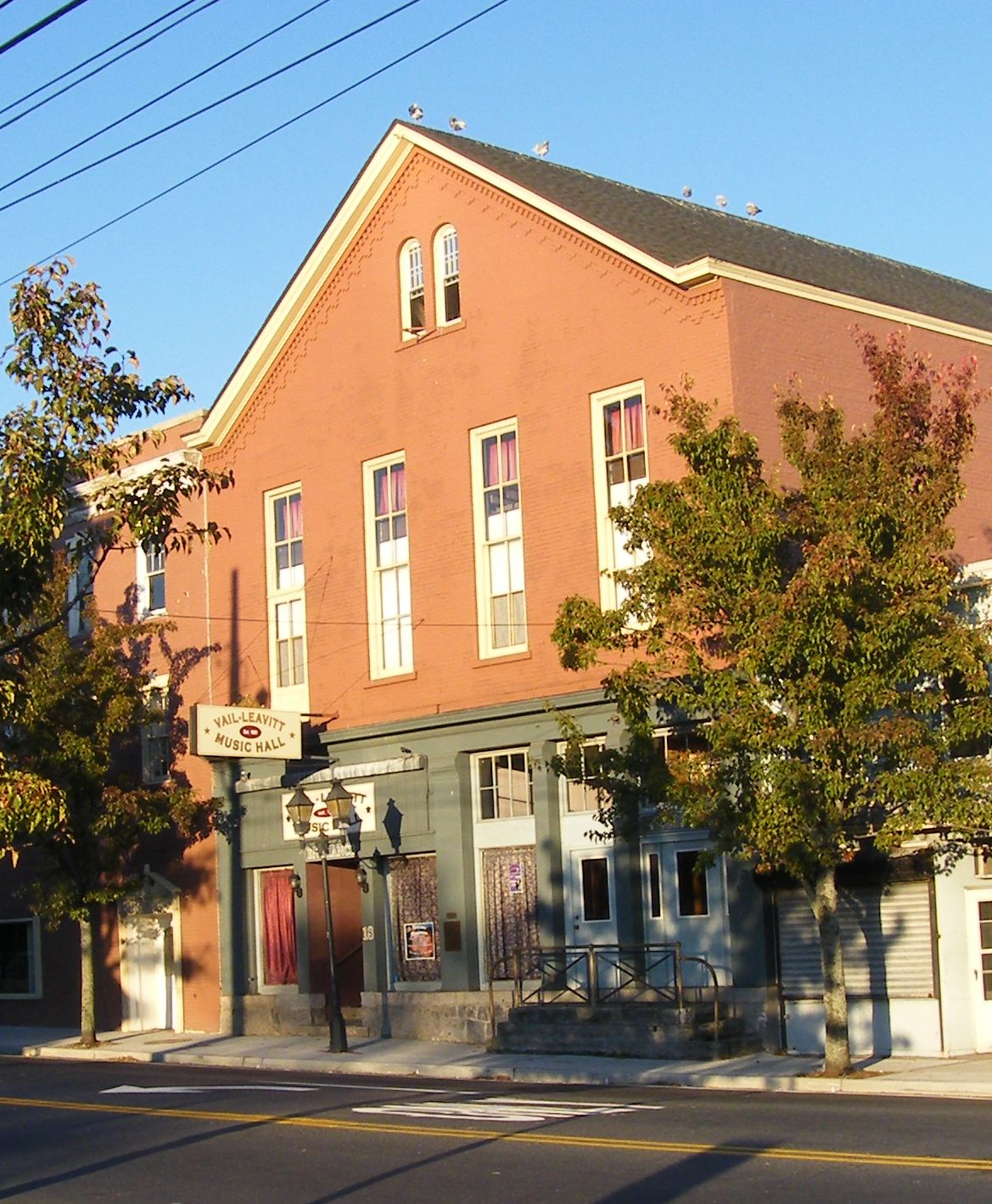
Vail-Leavitt Music Hall
Cinema and theater · National Register of Historic Places · 2.5 mi
Theater and former movie theater in Riverhead, New York, United States


Hubbard's Farm Stand
Farm and orchard · 3.2 mi
Meeting House Creek Road, Aquebogue

Museums and landmarks12

Big Duck
Monument and historic site · National Register of Historic Places · 4.1 mi
Historic commercial building in New York, United States

Big Duck Ranch
Monument and historic site · National Register of Historic Places · 4.1 mi
Building in New York, United States

Hallock Homestead
Monument and historic site · National Register of Historic Places · 5.2 mi
Historic house in New York, United States

Hallock-Bilunas Farmstead
Monument and historic site · National Register of Historic Places · 4.8 mi
Historic house in New York, United States

James Benjamin Homestead
Monument and historic site · National Register of Historic Places · 4.5 mi
Flanders, NY, listed on the NRHP in New York

Jamesport Meeting House
Monument and historic site · National Register of Historic Places · 5.0 mi
Historic meetinghouse in New York, United States

Jedediah Hawkins House
Monument and historic site · National Register of Historic Places · 5.0 mi
Historic house in New York, United States

Suffolk County Historical Society Building
Monument and historic site · National Register of Historic Places · 2.0 mi
Building in New York, United States

United States Post Office
Monument and historic site · National Register of Historic Places · 2.4 mi
Government building in Riverhead, New York


Suffolk County Historical Society Museum
Museum · 2.3 mi
300 West Main Street, Riverhead
Parks, trails and playgrounds26


Long Island Aquarium and Exhibition Center
Sports field and stadium · 2.5 mi
Aquarium in Riverhead, New York, United States
431 East Main Street, Riverhead
Mo-Su 10:00-18:00


Hallock State Park Preserve
Park · 5.0 mi
Park in Riverhead, United States of America

14 more on the map.
Restaurants and cafes58

Redefine Meals
Restaurant · American, Asian, Italian, Mexican · 1.4 mi
1105-1111 Old Country Road, Riverhead
Mo-Su 08:00-22:00


Jerry & The Mermaid
Restaurant · 2.5 mi
469 East Main Street, Riverhead
Mo-Su 11:00-22:00

Bagel Lovers Cafe
Restaurant · Coffee Shop · 1.9 mi
673 Osborne Avenue, Riverhead
Country Rotisserie
Restaurant · Chicken · 1.9 mi
1528 Old Country Road, Riverhead
Crystal Garden Buffet
Restaurant · Chinese · 1.4 mi
747 Old Country Road, Riverhead
46 more on the map.
History
The hamlet began with the Suffolk County Court House, a 1727 structure built to serve both the North and South Forks. Since that year, Riverhead (at the time known as "River Head") has served as the seat of Suffolk County, and still contains the primary courts of the region.
Riverhead's downtown area formed as an active commercial hub during the 19th century. In the beginning of the 20th century, the community saw an influx of Polish immigrants, as did the rest of the town. This led to the creation of Polish Town, where the popular Polish Town Fair is held annually. The downtown experienced urban blight during the mid-20th century, but recovered by the beginning of the 21st century.
From the History section of Riverhead (CDP), New York on Wikipedia, under CC BY-SA 4.0.
Where to stay8
Churches and places of worship23
Goodwill AME Zion Church
Church · Methodist · 2.7 mi
110 Flanders Road, Riverhead
Iglesia de Cristo de Riverhead
Church · Church Of Christ · 1.3 mi
1136 Ostrander Avenue, Riverhead
Riverhead United Methodist Church
Church · United Methodist · 2.5 mi
204 East Main Street, Riverhead
Seventh-Day Adventist Church Riverhead
Church · Seventh Day Adventist · 2.0 mi
538 Griffing Avenue, Riverhead
St. Isadore Roman Catholic Church
Church · Roman Catholic · 2.1 mi
622 Pulaski Street, Riverhead
St. John the Baptist Ukrainian Catholic Church
Church · Ukrainian Greek Catholic · 1.9 mi
820 Pondview Road, Riverhead
St. John the Evangelist Roman Catholic Church
Church · Roman Catholic · 2.1 mi
546 St. John's Place, Riverhead
Temple Israel of Riverhead
Place of worship · Conservative · 2.1 mi
490 Northville Turnpike, Riverhead
Shopping32
Gas and EV charging11
Schools, colleges and libraries20
Healthcare17
New York Cancer and Blood Specialists - Riverhead Radiation Oncology
Clinic and pharmacy · 1.2 mi
750 Old Country Road
Children's Health And Therapeutic Services
Clinic and pharmacy · 1.4 mi
1303 Roanoke Avenue, Riverhead
Dr. Bernadette Pupilla
Clinic and pharmacy · 1.5 mi
1149 Old Country Road, Riverhead
East End Allergy & Asthma Care
Clinic and pharmacy · 1.5 mi
1149 Old Country Road, Riverhead
East End Cardiology
Clinic and pharmacy · 1.9 mi
1279 East Main Street, Riverhead
Island Urgent Medical Care & Family Medicine
Clinic and pharmacy · 1.9 mi
1228 East Main Street, Riverhead
Maria L.S. Alcasid-Escano Adult & Pediatric Allergy
Clinic and pharmacy · 1.6 mi
982 Roanoke Avenue, Riverhead
MDVIP - Lilly Steel, MD
Clinic and pharmacy · 1.7 mi
25B Cranberry Street, Riverhead
North Fork Endocrinology
Clinic and pharmacy · 1.5 mi
1149 Old Country Road, Riverhead
Northwell Health Cardiology Office
Clinic and pharmacy · 1.6 mi
951 Roanoke Avenue, Riverhead
Map of Riverhead
215 places. The map loads OpenStreetMap tiles when you open it.
Climate by month
Monthly table
| Month | High | Low | Rain |
|---|---|---|---|
| Jan | 40°F | 26°F | 3.8 in |
| Feb | 41°F | 27°F | 3.3 in |
| Mar | 48°F | 33°F | 4.7 in |
| Apr | 60°F | 42°F | 4.1 in |
| May | 70°F | 51°F | 3.6 in |
| Jun | 79°F | 61°F | 3.8 in |
| Jul | 84°F | 67°F | 3.0 in |
| Aug | 82°F | 66°F | 3.9 in |
| Sep | 76°F | 60°F | 4.1 in |
| Oct | 65°F | 50°F | 4.5 in |
| Nov | 54°F | 40°F | 3.8 in |
| Dec | 45°F | 32°F | 4.6 in |
U.S. Climate Normals 1991-2020 for Riverhead Rsch Farm (2 mi away), NOAA NCEI.
People and cost of living
American Community Survey 5-year estimates, 2020-2024, U.S. Census Bureau. Estimates have margins of error, larger for small towns.
Disaster history
Suffolk County has had 25 federal disaster declarations since 2000, most often for hurricanes.
- 2024-10-21: Severe Storm And Flooding (Severe Storm)
- 2024-08-25: Severe Storm And Flooding (Severe Storm)
- 2023-03-15: Severe Winter Storm And Snowstorm (Snowstorm)
- 2021-09-05: Remnants Of Hurricane Ida (Hurricane)
- 2021-09-02: Remnants Of Hurricane Ida (Hurricane)
- 2021-08-22: Hurricane Henri (Hurricane)
OpenFEMA disaster declarations summaries.
Getting there and nearby towns
Calverton Executive Airpark (CTO) is the nearest airport with scheduled flights listed in OpenStreetMap, 6 miles away.
- Manorville 8 mi southwest, about 14 min by car
- Hampton Bays 10 mi southeast, about 16 min by car
- Ridge 11 mi west, about 18 min by car
- Mastic 13 mi southwest, about 21 min by car
- Rocky Point 14 mi west, about 22 min by car
- Middle Island 15 mi west, about 24 min by car
- Mastic Beach 15 mi southwest, about 25 min by car
- Miller Place 17 mi west, about 27 min by car
- Coram 18 mi west, about 29 min by car
- Medford 18 mi southwest, about 30 min by car
Drive times are estimates from straight-line distance, not routes.
Local news
Headlines from INDB, the NEMICO news database.
Reviews, tips and questions
Loading what members have shared...
Sources and licences
- NCES EDGE (Public domain): public schools
- NOAA NCEI U.S. Climate Normals 1991-2020 (Public domain): climate by month
- OpenFEMA (Public domain): disaster declarations
- OpenStreetMap contributors (ODbL 1.0): places, airports, map data
- U.S. Census Bureau (Public domain): population, income, housing, education, commute
- Wikidata (CC0 1.0): elevation, founding date, time zone, website, landmarks and historic places
- Wikimedia Commons (see each image): photos
- Wikipedia (CC BY-SA 4.0): overview and history text
Photo credits
- Riverhead, New York, USA (cropped), Quintin Soloviev, CC BY 4.0
- Pastoral scenery along Sound Avenue, Riverhead, New York - 20221124, Andre Carrotflower, CC BY-SA 4.0
- Greetings from Riverhead, Long Island, New York - Large Letter Postcard (8502248689), Steve Shook from Moscow, Idaho, USA, CC BY 2.0
- Riverhead Engine House, Don Fisher, CC BY-SA 4.0
- Jamesport Meeting House blocked by Chevy Silverado, DanTD, CC BY-SA 4.0
- Riverhead-post-office, Americasroof, CC BY-SA 3.0
- Jedediah-Hawkins-House, Americasroof, CC BY-SA 3.0
- Suffolk-historic, Americasroof, CC BY-SA 3.0
- Big Duck 2018 04, Photograph by Mike Peel ( www.mikepeel.net )., CC BY-SA 4.0
- Hallock-Homestead, Americasroof, CC BY-SA 3.0
- Vail-leavitt, Americasroof, CC BY-SA 3.0
- Big Duck 2018 05, Photograph by Mike Peel ( www.mikepeel.net )., Public domain
- Hallock-Bilunas-Farmstead, Americasroof, CC BY 3.0
- James Benjamin Homestead; Flanders, New York-2, DanTD, CC BY-SA 4.0
- Long Island Aquarium 2018 106, Photograph by Mike Peel ( www.mikepeel.net )., CC BY-SA 4.0
- 2000 Cadillac Seville SLS in Crimson Pearl, rear right, Mr.choppers, CC BY-SA 4.0
- 2000 Cadillac Seville SLS in Crimson Pearl, front right, Mr.choppers, CC BY-SA 4.0
- 2025 Toyota Camry Hybrid LE in Celestial Silver Metallic, rear left, Mr.choppers, CC BY-SA 4.0
- 2025 Toyota Camry Hybrid LE in Celestial Silver Metallic, front left, Mr.choppers, CC BY-SA 4.0
- 2025 Volvo XC40 B5 Plus in Silver Dawn, rear left, Mr.choppers, CC BY-SA 4.0
- 2025 Volvo XC40 B5 Plus in Silver Dawn, front right, Mr.choppers, CC BY-SA 4.0
- 2017 Ford Mustang EcoBoost in Ruby Red Metallic, front right, Mr.choppers, CC BY-SA 4.0
- 2017 Ford Mustang EcoBoost in Ruby Red Metallic, rear left, Mr.choppers, CC BY-SA 4.0
- 2025 Mercedes-Benz GLA 250 4Matic in Mountain Grey Metallic, rear left, Mr.choppers, CC BY-SA 4.0
- 2025 Mercedes-Benz GLA 250 4Matic in Mountain Grey Metallic, front left, Mr.choppers, CC BY-SA 4.0
- 2020 BMW M340i xDrive in Black Sapphire Metallic, rear left, Mr.choppers, CC BY-SA 4.0
- 2020 BMW M340i xDrive in Black Sapphire Metallic, front left, Mr.choppers, CC BY-SA 4.0
- Sadoc Vazkez 2021, Sadoc Vazkez, CC BY-SA 4.0
- Angry sky 272 - Flickr - Eric.Ray, Eric.Ray from Yaphank, NY, USA, CC BY 2.0
- At Long Island 2025 049, Photograph by Mike Peel ( www.mikepeel.net )., CC BY-SA 4.0
- At Long Island 2025 222, Photograph by Mike Peel ( www.mikepeel.net )., CC BY-SA 4.0
- At Long Island 2025 221, Photograph by Mike Peel ( www.mikepeel.net )., CC BY-SA 4.0
- At Long Island 2025 050, Photograph by Mike Peel ( www.mikepeel.net )., CC BY-SA 4.0
- At Long Island 2025 041, Photograph by Mike Peel ( www.mikepeel.net )., CC BY-SA 4.0
- At Long Island 2025 042, Photograph by Mike Peel ( www.mikepeel.net )., CC BY-SA 4.0
- At Long Island 2025 047, Photograph by Mike Peel ( www.mikepeel.net )., CC BY-SA 4.0
- At Long Island 2025 046, Photograph by Mike Peel ( www.mikepeel.net )., CC BY-SA 4.0
- At Long Island 2025 048, Photograph by Mike Peel ( www.mikepeel.net )., CC BY-SA 4.0
- At Long Island 2025 051, Photograph by Mike Peel ( www.mikepeel.net )., CC BY-SA 4.0
- At Long Island 2025 220, Photograph by Mike Peel ( www.mikepeel.net )., CC BY-SA 4.0


Page built October 30, 2026. Spotted a mistake? Tell us or suggest a place.