


Rochester, Minnesota
Rochester is a city of 122,330 people in Olmsted County, Minnesota, founded in 1854.
Why visit Rochester
Townapedia lists 30 museums and landmarks, 101 parks and trails, 200 places to eat, 46 places to stay and 11 attractions in and around town.
Highlights include Mayo Civic Center, University Center Rochester, Plummer House and Chateau Theatre.
July is the warmest month, with average highs of 80°F; January lows average 7°F, and about 53 inches of snow fall in a normal year.
Weather in Rochester
Forecast from the National Weather Service. Full forecast
About Rochester
Rochester is a city in and the county seat of Olmsted County, Minnesota, United States. It is located along rolling bluffs on the Zumbro River's south fork in Southeast Minnesota. The population was 121,395 at the 2020 census, and was estimated at 124,292 in 2025, making it the third-most populous city in Minnesota. The Rochester metropolitan area has an estimated 230,000 residents.
From the Wikipedia article Rochester, Minnesota (this version), under CC BY-SA 4.0.
Things to do11

Mayo Civic Center
Cinema and theater · 1.1 mi
Multi-purpose sports, events, convention and cultural center in Rochester, Minnesota, United States

Cinemagic Hollywood 12 Theatres
Cinema and theater · 3.1 mi
2171 Superior Drive NW, Rochester

Museums and landmarks30

Plummer House
Monument and historic site · National Register of Historic Places
Historic house in Minnesota, United States

Chateau Theatre
Cinema and theater · National Register of Historic Places · 0.9 mi
Former theater and movie theater in Rochester, Minnesota, United States, later converted to a bookstore
15 1st Street Northwest, Rochester

Plummer Building
Monument and historic site · National Register of Historic Places · 0.8 mi
Building in the United States

Avalon Music
Monument and historic site · National Register of Historic Places · 1.1 mi
Architectural structure
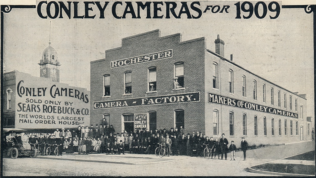
Conley–Maass–Downs Building
Monument and historic site · National Register of Historic Places · 0.8 mi
Commercial building in Rochester, Minnesota

Dr. William J. Mayo House
Monument and historic site · National Register of Historic Places · 0.5 mi
Historic house in Minnesota, United States

Frank's Ford Bridge
Monument and historic site · National Register of Historic Places · 8.0 mi
Historic road bridge near Oronoco, Minnesota, United States

George Stoppel Farmstead
Monument and historic site · National Register of Historic Places · 1.6 mi
Building in Rochester Township, Minnesota, United States


Pill Hill, Rochester, Minnesota
Monument and historic site · National Register of Historic Places
Historic house in Minnesota, United States

Rochester Art Center
Museum · 1.1 mi
Art Center in Minnesota, United States
40 Civic Center Drive Southeast, Rochester
18 more on the map.
Parks, trails and playgrounds101



89 more on the map.
Restaurants and cafes200

Outback Steakhouse
Restaurant · American, Steak · 0.9 mi
1201 South Broadway Avenue, Rochester
Mo-Th 11:00-22:00; Fr,Sa 11:00-22:30; Su 11:00-21:00

WinCity Wings
Cafe · Wings · 2.1 mi
Permenantly installed food truck, "Jimmie G's Wincity Wings & Beef"
2040 Viking Drive Northwest, Rochester
Tu-Sa 11:00-20:00; Su 12:00-18:00
Fuzzy's Italian Ice
Restaurant · Dessert · 0.8 mi
318 1st Avenue Southwest, Rochester
Mo-Sa 11:00-22:00
Hunan Bistro
Restaurant · Chinese · 0.8 mi
34 17th Avenue Northwest
Mo,Su,We-Th 11:00-21:00; Tu off; Fr-Sa 11:00-22:00
Ityhaas Express
Restaurant · Indian · 1.0 mi
1121 Civic Center Drive Northwest
Mo-Sa 11:00-21:00; Su 12:00-20:00
Los Dos Amigos
Restaurant · Mexican · 1.8 mi
1611 West Frontage Road Northwest, Rochester
Mo-Th 11:00-22:00; Fr 11:00-23:00; Sa 11:00-22:30; Su 11:00-21:30
Old Abe
Cafe · Coffee Shop, Donut, Sandwich, Bagel, Asian, Thai, European · 1.2 mi
832 7th Street Northwest, Rochester
We-Sa 07:00-19:00; Su 07:00-17:00
Pho Chau
Restaurant · Vietnamese, Asian · 1.6 mi
1014 North Broadway Avenue, Rochester
Mo-Sa 11:00-19:45, Su 11:00-18:45
Spyhouse Coffee Roasters
Cafe · Coffee Shop · 0.6 mi
601 2nd Street Southwest, Rochester
Mo-Th 06:00-21:00; Fr 06:00-22:00; Sa-Su 07:00-22:00
ThaiPop
Restaurant · Thai · 0.9 mi
4 3rd Street Southwest, Rochester
Mo 16:00-21:00, Tu-Th 11:00-21:00, Fr-Sa 11:00-22:00, Su closed
Victoria's Ristorante & Wine Bar
Restaurant · Italian · 0.9 mi
7 1st Avenue SW, Rochester
Mo-Su 10:30-22:00
188 more on the map.
History
Several indigenous peoples such as Dakota, Ojibway, and Ho-Chunk inhabited the Rochester area. The community was founded by George Head and his wife Henrietta, who built a log cabin named Head's Tavern in 1854. It was named for Head's hometown of Rochester, New York. The city developed as a stagecoach stop along the Zumbro River on a route between Dubuque, Iowa, and Saint Paul, Minnesota. When the Winona and St. Peter Railroad initiated service in October 1864, it brought new residents and business opportunities and spurred growth.
In 1863, William W. Mayo arrived as the examining surgeon for Union draftees in the Civil War. The 1883 Rochester Tornado demolished much of Rochester, leaving 37 dead and approximately 200 injured. As there was no medical facility in the immediate area at the time, Mayo and his two sons worked together to care for the wounded. Donations of US$60,000 (US$1,932,562 in 2022) were collected and the Sisters of St. Francis, assisted by Mayo, opened a new facility named St. Marys Hospital in 1889.
From the History section of Rochester, Minnesota on Wikipedia, under CC BY-SA 4.0.
Where to stay46
Broadway Residence and Suites by Bridgestreet
Motel and hotel · 1.0 mi
15 1st Street Southeast, Rochester
Churches and places of worship49
Co-Cathedral of Saint John the Evangelist
Church · Catholic · 0.8 mi
11 4th Avenue Southwest, Rochester
Kingdom Hall of Jehovah's Witnesses
Church · Jehovahs Witness · 0.4 mi
921 West Frontage Road SW, Rochester
Saints Kosmas & Damianos Orthodox Church
Church · Greek Orthodox · 0.7 mi
703 West Center Street, Rochester
Shopping57
Gas and EV charging24
Schools, colleges and libraries85
Healthcare20
Community Behavioral Health Hospital - Rochester
Hospital · 3.1 mi
251 Wood Lake Drive Southeast, Rochester
Map of Rochester
250 places. The map loads OpenStreetMap tiles when you open it.
Climate by month
Monthly table
| Month | High | Low | Rain | Snow |
|---|---|---|---|---|
| Jan | 22°F | 7°F | 1.0 in | 12.2 in |
| Feb | 27°F | 11°F | 1.0 in | 10.7 in |
| Mar | 40°F | 23°F | 2.0 in | 8.6 in |
| Apr | 55°F | 35°F | 3.5 in | 3.3 in |
| May | 68°F | 47°F | 4.3 in | 0.5 in |
| Jun | 78°F | 58°F | 5.3 in | 0.0 in |
| Jul | 80°F | 61°F | 4.2 in | 0.0 in |
| Aug | 78°F | 58°F | 4.1 in | 0.0 in |
| Sep | 72°F | 50°F | 3.6 in | 0.0 in |
| Oct | 58°F | 38°F | 2.4 in | 0.9 in |
| Nov | 42°F | 26°F | 1.8 in | 4.5 in |
| Dec | 28°F | 14°F | 1.3 in | 12.4 in |
U.S. Climate Normals 1991-2020 for Rochester Intl Ap 72644 (8 mi away), NOAA NCEI.
People and cost of living
American Community Survey 5-year estimates, 2020-2024, U.S. Census Bureau. Estimates have margins of error, larger for small towns.
Disaster history
Olmsted County has had 9 federal disaster declarations since 2000, most often for severe storms.
- 2020-04-07: Covid-19 Pandemic (Biological)
- 2020-03-13: Covid-19 (Biological)
- 2019-06-12: Severe Winter Storm, Straight-Line Winds, And Flooding (Flood)
- 2010-10-13: Severe Storms And Flooding (Severe Storm)
- 2010-07-02: Severe Storms, Tornadoes, And Flooding (Tornado)
- 2007-08-23: Severe Storms And Flooding (Severe Storm)
OpenFEMA disaster declarations summaries.
Getting there and nearby towns
Rochester International Airport (RST) is the nearest airport with scheduled flights listed in OpenStreetMap, 7 miles away.
- Byron 8 mi west, about 13 min by car
- Marion 8 mi southeast, about 13 min by car
- Stewartville 11 mi south, about 17 min by car
- Oronoco 11 mi north, about 17 min by car
- Eyota 12 mi east, about 20 min by car
- Kasson 13 mi west, about 22 min by car
- Elgin 14 mi northeast, about 22 min by car
- Mantorville 14 mi west, about 22 min by car
- Pine Island 15 mi northwest, about 24 min by car
- Plainview 19 mi northeast, about 30 min by car
Drive times are estimates from straight-line distance, not routes.
Local news
Headlines from INDB, the NEMICO news database.
Reviews, tips and questions
Loading what members have shared...
Sources and licences
- NCES EDGE (Public domain): public schools
- NOAA NCEI U.S. Climate Normals 1991-2020 (Public domain): climate by month
- OpenFEMA (Public domain): disaster declarations
- OpenStreetMap contributors (ODbL 1.0): places, airports, map data
- U.S. Census Bureau (Public domain): population, income, housing, education, commute
- Wikidata (CC0 1.0): elevation, founding date, time zone, website, landmarks and historic places
- Wikimedia Commons (see each image): photos
- Wikipedia (CC BY-SA 4.0): overview and history text
Photo credits
- Rochester Minnesota Skyline 04, Wikideas1, CC0
- PlummerHouse, Jonathunder, CC BY-SA 3.0
- 2017ChateauRochesterMN, Jonathunder, GFDL 1.2
- Plummer-building, Jonathunder, CC BY-SA 3.0
- 2010-1014-FranksFordBridge, Bobak Ha'Eri, CC BY 3.0
- FoundationHouse, Jonathunder, GFDL 1.2
- 2010-1014-PillHillRHD, Bobak Ha'Eri, CC BY 3.0
- AvalonRochesterMN, Jonathunder, CC BY-SA 3.0
- StoppelFarm, Jonathunder, CC BY-SA 3.0
- 1909ConleyCamera, Sears Roebuck, Public domain
- 10th Ave (807), Firzlaff, CC BY-SA 4.0
- 10th Ave (801), Firzlaff, CC BY-SA 4.0
- 10th Ave (814), Firzlaff, CC BY-SA 4.0
- 8th St (930), Firzlaff, CC BY-SA 4.0
- 10th Ave (725), Firzlaff, CC BY-SA 4.0
- 10th Ave (723), Firzlaff, CC BY-SA 4.0
- 10th Ave (726), Firzlaff, CC BY-SA 4.0
- 10th Ave (715), Firzlaff, CC BY-SA 4.0
- 8th St (912), Firzlaff, CC BY-SA 4.0
- 8th St (915), Firzlaff, CC BY-SA 4.0
- 10th Ave (720), Firzlaff, CC BY-SA 4.0
- 7th St (1014), Firzlaff, CC BY-SA 4.0
- 9th Ave (831), Firzlaff, CC BY-SA 4.0
- 9th Ave (801), Firzlaff, CC BY-SA 4.0
- 10th Ave (703), Firzlaff, CC BY-SA 4.0
- 10th Ave (718), Firzlaff, CC BY-SA 4.0
- 8th St (909), Firzlaff, CC BY-SA 4.0
- 9th Ave (841), Firzlaff, CC BY-SA 4.0
- 841 9th Ave SW, DL559, CC BY-SA 4.0
- 9th Ave (709), Firzlaff, CC BY-SA 4.0
- 8th St (828), Firzlaff, CC BY-SA 4.0
- 7th St (1005), Firzlaff, CC BY-SA 4.0
- 9th Ave (816), Firzlaff, CC BY-SA 4.0
- 9th Ave (822), Firzlaff, CC BY-SA 4.0
- 9th Ave (701), Firzlaff, CC BY-SA 4.0
- 7th St (1103), Firzlaff, CC BY-SA 4.0
- 10th Ave (620), Firzlaff, CC BY-SA 4.0
- 8th St (827), Firzlaff, CC BY-SA 4.0
- 8th St (818), Firzlaff, CC BY-SA 4.0
- 7th St (1115), Firzlaff, CC BY-SA 4.0


Page built October 30, 2026. Spotted a mistake? Tell us or suggest a place.