
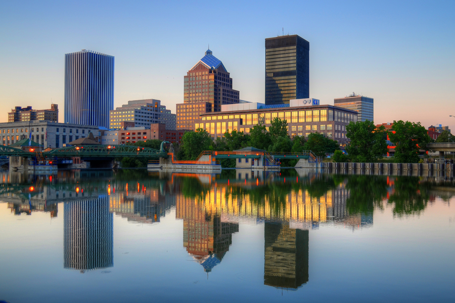


Rochester, New York
Rochester is a city of 208,772 people in Monroe County, New York, founded in March 21, 1817.
Why visit Rochester
Townapedia lists 126 museums and landmarks, 59 parks and trails, 248 places to eat, 8 places to stay and 24 attractions in and around town.
Highlights include Hochstein School of Music & Dance, Kodak Center, Central Library of Rochester & Monroe County and Memorial Art Gallery.
July is the warmest month, with average highs of 82°F; January lows average 19°F, and about 102 inches of snow fall in a normal year.
Weather in Rochester
Forecast from the National Weather Service. Full forecast
About Rochester
Rochester is a city in and the county seat of Monroe County, New York, United States. It is the fourth-most populous city in New York, with a population of 206,108 as of the 2025 Census estimate. The Rochester metropolitan area in Western New York has an estimated 1.05 million residents and is the 54th-largest metropolitan area in the U.S. Throughout its history, Rochester has acquired several nicknames based on local industries; it has been known as "the Flour City" and "the Flower City" for its dual role in flour production and floriculture, and as the "World's Image Center" for its association with film, optics, and photography.
From the Wikipedia article Rochester, New York (this version), under CC BY-SA 4.0.
Things to do24

Harro East Ballroom
Cinema and theater · 0.9 mi
Landmark and historic Concert Hall, Theater, and Event space.
155 North Chestnut Street, Rochester

Irondequoit Bay Outlet Bridge
Bridge · 6.1 mi
Bridge in Monroe County, New York, United States of America
Little Theatre
Cinema and theater · 1.3 mi
Independant movie house
240 East Avenue, Rochester
Eastman Theatre
Cinema and theater · 1.2 mi
40 Gibbs Street, Rochester


Pont de Rennes
Scenic view · 0.5 mi
Unobstructed view of High Falls waterfall and High Falls Genesee River Gorge
12 more on the map.
Museums and landmarks126

Central Library of Rochester & Monroe County
Monument and historic site · 1.2 mi
Spanning both sides of South Avenue, connected by the underground pedestrian tunnel "Central Library Tunnel", the Rundel Memorial...
115 South Avenue, Rochester
Mo-Th 09:00-19:00; Fr 09:00-17:00; Sa 10:00-17:00

Memorial Art Gallery
Museum · 1.7 mi
500 University Avenue, Rochester
We, Fr-Su 11:00-17:00; Th 11:00-20:00

Susan B. Anthony House
Museum · National Register of Historic Places · 1.3 mi
Historic building in Rochester, New York
17 Madison Street, Rochester
Tu-Su 11:00-17:00

Andrews Street Bridge
Monument and historic site · National Register of Historic Places · 0.8 mi
Historic stone arch bridge located at Rochester in Monroe County, New York

Aquinas Institute
Monument and historic site · Catholic · National Register of Historic Places · 1.7 mi
School in Rochester, New York state, USA

Broad Street Bridge
Monument and historic site · National Register of Historic Places · 1.1 mi
Bridge and aqueduct in Rochester, New York, United States
Gannett Building
Monument and historic site · National Register of Historic Places · 1.1 mi
Building in Rochester, New York, United States
55 Exchange Boulevard, Rochester

George Eastman Museum
Museum · National Register of Historic Places · 2.2 mi
Film and photography museum and archive in Rochester, New York, United States
900 East Avenue, Rochester


Geva Theatre Center
Monument and historic site · National Register of Historic Places · 1.4 mi
Theatre in Rochester, New York
75 Woodbury Boulevard, Rochester
Granite Building
Monument and historic site · National Register of Historic Places · 1.0 mi
Historic commercial building in New York, United States
130 East Main Street, Rochester
Hervey Ely House
Monument and historic site · National Register of Historic Places · 1.3 mi
Historic house in New York, United States
138 Troup Street, Rochester
Main Street Bridge
Monument and historic site · National Register of Historic Places · 1.0 mi
Bridge in Rochester, New York
114 more on the map.
Parks, trails and playgrounds59


The Blue Cross Arena at the War Memorial
Sports field and stadium · 1.2 mi
1 War Memorial Square, Rochester
Holleder Memorial Stadium
Park · 2.6 mi
Park in New York, United States of America, United States of America
Irondequoit Bay State Marine Park
Park · 5.8 mi
State park in Monroe County, New York
Middle Maplewood Park
Park · 1.3 mi
Located in the Seneca Parkway area, features tennis courts, open play space and beautiful views of the river along the Riverway Trail.
Rochester Community Sports Complex Stadium
Sports field and stadium · 0.8 mi
Previously known as PAETEC Park, Marina Auto Stadium, Sahlen's Stadium, and Capelli Sport Stadium.
490 Farms
Park · 2.1 mi
Community Garden with plots for reserve and a free food forest. Also accepts compost material
Grand Avenue Park
Park · 2.2 mi
250 Grand Avenue, Rochester
Mo-Su 06:00-22:00; Apr-Nov Mo-Su 05:00-23:00
47 more on the map.
Restaurants and cafes248

AM:FM
Cafe · Coffee Shop, Soup, Sandwich, Tea, Burger · 1.1 mi
Café serving breakfast, brunch, specialty coffee, and espresso drinks.
45 Euclid Street, Rochester
Mo-Tu 06:00-12:00 "coffee and case sandwiches only"; We-Fr...

Swiftwater Brewing
Brewery and winery · 1.9 mi
Serving beer on draft and to go, and offering indoor and outdoor seating and dining.
378 Mount Hope Avenue, Rochester
Tu 18:00-22:00; We-Th 12:00-22:00; Fr-Sa 12:00-23:00; Su 14:00-21:00
Bicycle Brothers Coffee
Cafe · Sandwich, Coffee Shop · 2.2 mi
162 Arnett Boulevard, Rochester
Mo-Su 07:00-14:00

Bitter Honey
Restaurant · Mexican · 1.5 mi
127 Railroad Street
Tu-Th 16:00-22:00; Fr 16:00-23:00; Sa 14:00-23:00
Carnegie Cellars
Restaurant · Wine, Tapas · 1.8 mi
247 North Goodman Street, Rochester
We-Sa 16:00-23:00; Su 12:00-19:00

Crisp Rochester
Diner · American · 2.2 mi
819 South Clinton Avenue, Rochester
Su,Mo 11:00-14:45; Su,Mo 16:00-21:00; Th-Sa 11:30-22:00
Equal Grounds Community Cafe
Cafe · Coffee Shop, Sandwich · 2.1 mi
750 South Avenue, Rochester
Mo-Fr 08:00-22:00; Sa-Su 09:00-22:00

Flora
Bar and pub · 1.6 mi
Flora is a queer owned LGBTQ+ Bar offering craft cocktails
190 Monroe Avenue, Rochester
Su 16:00-24:00; We-Th 16:00-24:00; Fr-Sa 16:00-02:00
Founders Café
Cafe · Deli, Tea, Sandwich, Grill, Coffee Shop, Breakfast · 1.1 mi
13 South Fitzhugh Street, Rochester
Mo-Fr 07:00-17:00; Sa 09:00-15:00
236 more on the map.
Where to stay8
School 31 Luxury Lofts
Motel and hotel · 1.8 mi
208 Goodman Street North, Rochester
Churches and places of worship34
Immaculate Conception Church
Church · National Register of Historic Places · 1.6 mi
Saint Andrew's Episcopal Church
Church · National Register of Historic Places · 1.7 mi
Greek Orthodox Church of the Holy Spirit
Church · Greek Orthodox · 2.2 mi
835 South Avenue, Rochester
Kingdom Hall of Jehovah’s Witnesses
Church · Jehovahs Witness · 2.3 mi
1037 South Plymouth Avenue, Rochester
Saint Mary's Catholic Church
Church · Catholic · 1.3 mi
15 Saint Mary's Place, Rochester
Shopping36
Gas and EV charging17
Schools, colleges and libraries118
Healthcare15
Rochester Regional Health: Rochester General Campus
Hospital · 2.1 mi
1425 Portland Avenue, Rochester
Rochester General Hospital Medical Office Building
Clinic and pharmacy · 2.1 mi
1415 Portland Avenue, Rochester
Evelyn Brandon Health Center Personalized Recovery Oriented Services
Clinic and pharmacy · 0.5 mi
81 Lake Avenue, Rochester
Map of Rochester
250 places. The map loads OpenStreetMap tiles when you open it.
Climate by month
Monthly table
| Month | High | Low | Rain | Snow |
|---|---|---|---|---|
| Jan | 33°F | 19°F | 2.5 in | 27.4 in |
| Feb | 35°F | 20°F | 2.1 in | 23.1 in |
| Mar | 44°F | 27°F | 2.5 in | 17.9 in |
| Apr | 57°F | 37°F | 3.0 in | 3.0 in |
| May | 69°F | 48°F | 2.9 in | 0.1 in |
| Jun | 78°F | 57°F | 3.4 in | 0.0 in |
| Jul | 82°F | 62°F | 3.6 in | 0.0 in |
| Aug | 80°F | 61°F | 3.3 in | 0.0 in |
| Sep | 74°F | 54°F | 3.2 in | 0.0 in |
| Oct | 61°F | 43°F | 3.2 in | 0.1 in |
| Nov | 49°F | 34°F | 2.8 in | 8.1 in |
| Dec | 38°F | 25°F | 2.7 in | 22.3 in |
U.S. Climate Normals 1991-2020 for Rochester Gtr Intl Ap Hcn 72529 (5 mi away), NOAA NCEI.
People and cost of living
American Community Survey 5-year estimates, 2020-2024, U.S. Census Bureau. Estimates have margins of error, larger for small towns.
Disaster history
Monroe County has had 11 federal disaster declarations since 2000, most often for biologicals.
- 2020-03-20: Covid-19 Pandemic (Biological)
- 2020-03-13: Covid-19 (Biological)
- 2017-11-14: Flooding (Flood)
- 2012-10-28: Hurricane Sandy (Hurricane)
- 2005-09-30: Hurricane Katrina Evacuation (Hurricane)
- 2004-10-01: Severe Storms And Flooding (Severe Storm)
OpenFEMA disaster declarations summaries.
Getting there and nearby towns
Greater Rochester International Airport (ROC) is the nearest airport with scheduled flights listed in OpenStreetMap, 4 miles away.
- Irondequoit 4 mi northeast, about 6 min by car
- Brighton 4 mi southeast, about 6 min by car
- Gates 4 mi west, about 6 min by car
- North Gates 5 mi west, about 7 min by car
- Greece 5 mi northwest, about 8 min by car
- Rochester Institute of Technology 7 mi southwest, about 11 min by car
- St. John Fisher College 7 mi southeast, about 11 min by car
- Nazareth College 7 mi southeast, about 11 min by car
- Pittsford 7 mi southeast, about 12 min by car
- East Rochester 8 mi southeast, about 12 min by car
Drive times are estimates from straight-line distance, not routes.
Local news
Headlines from INDB, the NEMICO news database.
Reviews, tips and questions
Loading what members have shared...
Sources and licences
- NCES EDGE (Public domain): public schools
- NOAA NCEI U.S. Climate Normals 1991-2020 (Public domain): climate by month
- OpenFEMA (Public domain): disaster declarations
- OpenStreetMap contributors (ODbL 1.0): places, airports, map data
- U.S. Census Bureau (Public domain): population, income, housing, education, commute
- Wikidata (CC0 1.0): elevation, founding date, time zone, website, landmarks and historic places
- Wikimedia Commons (see each image): photos
- Wikipedia (CC BY-SA 4.0): overview and history text
Photo credits
- Downtown Rochester, NY HDR by patrickashley, Patrick Ashley, CC BY 2.0
- RochesterNewYorkFamilyNewYearsEve2018PartyAtTheConventionCenterDeejay, DanielPenfield, CC BY-SA 4.0
- RochesterNewYorkFamilyNewYearsEve2018PartyAtTheConventionCenterWreckingBall, DanielPenfield, CC BY-SA 4.0
- StMichaelsChurchRochesterMidnightMass2023Organ, DanielPenfield, CC BY 4.0
- StMichaelsChurchRochesterNewYork11thStationOfTheCross, DanielPenfield, CC BY-SA 4.0
- StMichaelsChurchRochesterChristmasEveMass2019SideAltar, DanielPenfield, CC BY-SA 4.0
- StMichaelsChurchRochesterChristmasEveMass2019Eucharist, DanielPenfield, CC BY-SA 4.0
- StMichaelsChurchRochesterChristmasEveMass2019SanctuaryB, DanielPenfield, CC BY-SA 4.0
- StMichaelsChurchRochesterNewYorkReservedPew, DanielPenfield, CC BY-SA 4.0
- StMichaelsChurchRochesterNewYorkNaveLookingTowardChoir, DanielPenfield, CC BY-SA 4.0
- ArchangelMichaelStatueRochesterNewYork, DanielPenfield, CC BY-SA 4.0
- StMichaelsChurchRochesterNewYorkSteeple, DanielPenfield, CC BY-SA 4.0
- StMichaelsChurchRochesterNewYorkNaveLookingTowardSanctuary, DanielPenfield, CC BY-SA 4.0
- StMichaelsChurchRochesterNewYorkFromNorthwest, DanielPenfield, CC BY-SA 4.0
- Race and ethnicity- Rochester (5010405127), Eric Fischer, CC BY-SA 2.0
- Race and ethnicity 2010- Rochester (5559859651), Eric Fischer, CC BY-SA 2.0
- Kodak Building, State Street, Brown Square, Rochester, NY (54419901271), Warren LeMay from Chicago, IL, United States, CC BY-SA 2.0
- Kodak Building, State Street, Brown Square, Rochester, NY (54419901216), Warren LeMay from Chicago, IL, United States, CC BY-SA 2.0
- Kodak Building, State Street, Brown Square, Rochester, NY (54419044522), Warren LeMay from Chicago, IL, United States, CC BY-SA 2.0
- Pont De Rennes Bridge rennovation Rochester NY 2024-04-06 13-08-49 1, G. Edward Johnson, CC BY 4.0
- State Street, Brown Square, Rochester, NY (54420290320), Warren LeMay from Chicago, IL, United States, CC BY-SA 2.0
- Lyell Avenue and Smith Street, Brown Square, Rochester, NY (54420290230), Warren LeMay from Chicago, IL, United States, CC BY-SA 2.0
- Pont De Rennes Bridge Rochester NY, Kenneth C. Zirkel, CC BY-SA 4.0
- State Street, Brown Square, Rochester, NY (54419044572), Warren LeMay from Chicago, IL, United States, CC BY-SA 2.0
- Genesee Upper Fall, Rochester, N.Y. (3991215146), New York Public Library, No restrictions
- State Street, Brown Square, Rochester, NY (54420149173), Warren LeMay from Chicago, IL, United States, CC BY-SA 2.0
- Kodak Building, State Street, Brown Square, Rochester, NY (54420149078), Warren LeMay from Chicago, IL, United States, CC BY-SA 2.0
- Rochester NY Pont de Rennes E 2001, Andreas F. Borchert, CC BY-SA 4.0
- Rochester NY Pont de Rennes W 2001, Andreas F. Borchert, CC BY-SA 4.0
- Kodak Building, State Street, Brown Square, Rochester, NY (54419901111), Warren LeMay from Chicago, IL, United States, CC BY-SA 2.0
- Kodak Building, State Street, Brown Square, Rochester, NY (54419901091), Warren LeMay from Chicago, IL, United States, CC BY-SA 2.0
- Kodak Building, State Street, Brown Square, Rochester, NY (54420148978), Warren LeMay from Chicago, IL, United States, CC BY-SA 2.0
- Rochester NY High Falls 2001, Andreas F. Borchert, CC BY-SA 4.0
- Susan-b-anthony-house, Dmadeo, CC BY-SA 4.0
- FederalBuildingRochesterNewYorkFrontView, DanielPenfield, CC BY-SA 3.0
- Rochester - Geva Theatre - Rear Angle, Matthew D. Wilson ( LtPowers ), CC BY-SA 3.0
- Rochester - Andrews Street Bridge, Matthew D. Wilson ( LtPowers ), CC BY-SA 3.0
- George-Eastman-House=Exterior, Dmadeo, CC BY-SA 4.0
- Aquinas Institute front entrance, DanielPenfield, CC BY-SA 3.0
- Rochester NY Broad Street Bridge 2002, Andreas F. Borchert, CC BY-SA 4.0


Page built October 30, 2026. Spotted a mistake? Tell us or suggest a place.