


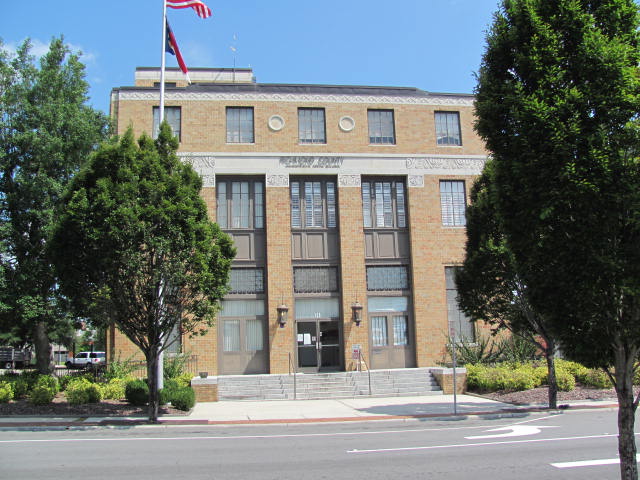

Rockingham, North Carolina
Rockingham is a city of 8,967 people in Richmond County, North Carolina, founded in 1784.
Why visit Rockingham
Townapedia lists 11 museums and landmarks, 8 parks and trails, 21 places to eat and 9 places to stay in and around town.
Highlights include Bank of Pee Dee Building and Covington Plantation House.
July is the warmest month, with average highs of 92°F; January lows average 33°F.
Weather in Rockingham
Forecast from the National Weather Service. Full forecast
About Rockingham
Rockingham is a city in Richmond County, North Carolina, United States, named after the Marquess of Rockingham. The population was 9,243 at the 2020 census. It is the county seat of Richmond County.
From the Wikipedia article Rockingham, North Carolina (this version), under CC BY-SA 4.0.
Museums and landmarks11

Bank of Pee Dee Building
Monument and historic site · National Register of Historic Places · 0.7 mi
Building in Rockingham, United States of America

Covington Plantation House
Monument and historic site · National Register of Historic Places · 3.7 mi
Historic house in North Carolina, United States

H. C. Watson House
Monument and historic site · National Register of Historic Places · 1.0 mi
Historic home located at Rockingham, Richmond County, North Carolina

Hannah Pickett Mill No. 1
Monument and historic site · National Register of Historic Places · 1.5 mi
Textile mill in Rockingham, North Carolina

Manufacturers Building
Monument and historic site · National Register of Historic Places · 0.6 mi
Building in Rockingham, United States of America
Richmond County Courthouse
Monument and historic site · National Register of Historic Places · 0.7 mi
Courthouse in North Carolina, United States

Roberdel Mill No. 1 Company Store
Monument and historic site · National Register of Historic Places · 2.5 mi
Building in Rockingham, United States of America

Rockingham County Courthouse
Monument and historic site · National Register of Historic Places · 0.7 mi
Courthouse in North Carolina, United States


Rockingham Historic District
Monument and historic site · National Register of Historic Places
Historic district in North Carolina, United States
U. S. Post Office and Federal Building
Monument and historic site · National Register of Historic Places · 0.7 mi
Building in Rockingham, North Carolina, United States
Parks, trails and playgrounds8


Restaurants and cafes21


Sly's Famous Diner
Restaurant · Southern · 0.7 mi
801 Broad Avenue, Rockingham

Domino's
Fast food · Pizza · 1.1 mi
1205 East Broad Avenue, Rockingham
Mo-Th 11:00-24:00; Fr-Sa 11:00-01:00; Su 11:00-24:00
Subway
Fast food · Sandwich · 0.7 mi
300 East Broad Street, Rockingham
Mo-We 08:00-21:00; Th-Fr 08:00-21:30; Sa 08:00-21:00; Su 09:00-21:00
9 more on the map.
Where to stay9

Americas Best Value Inn Rockingham
Motel and hotel · 1.0 mi
516 South Hancock Street, Rockingham
History
The city was named for Charles Watson-Wentworth, 2nd Marquess of Rockingham, British Prime Minister from 1765 to 1766 and again in 1782. Rockingham's administration was dominated by the issue of the Thirteen Colonies. Rockingham wanted to repeal the Stamp Act 1765 and won a Commons vote in 1766 on the repeal resolution by 275 to 167. As a result, he was a popular figure among British colonists in America (who would later become known simply as "Americans"). People in North Carolina were still sympathetic toward him in the years following the United States gaining independence.
During the early 19th century, numerous families from here migrated to Middle Tennessee, settling in what is now Nolensville. They quickly established their new community.
In 1950, the town fielded a professional minor league baseball team in the Class D Tobacco State League, the Rockingham Eagles. The club won the playoff title in their only season before disbanding with the entire league.
Rockingham has a number of historic buildings which have been listed on the National Register of Historic Places since the late 1970s: the Bank of Pee Dee Building, Covington Plantation House, Alfred Dockery House, Hannah Pickett Mill No. 1, Manufacturers Building, Richmond County Courthouse, Roberdel Mill No. 1 Company Store, Rockingham Historic District, U.S. Post Office and Federal Building, and H. C. Watson House.
From the History section of Rockingham, North Carolina on Wikipedia, under CC BY-SA 4.0.
Churches and places of worship17
Southwood Pentecostal Holiness Church
Church · Pentecostal · 2.4 mi
468 US-1, Rockingham
Shopping6
Gas and EV charging11
Schools, colleges and libraries22
Healthcare4
Map of Rockingham
109 places. The map loads OpenStreetMap tiles when you open it.
Climate by month
Monthly table
| Month | High | Low | Rain | Snow |
|---|---|---|---|---|
| Jan | 54°F | 33°F | 3.7 in | 0.0 in |
| Feb | 59°F | 35°F | 3.3 in | 0.3 in |
| Mar | 66°F | 42°F | 3.7 in | 0.0 in |
| Apr | 76°F | 51°F | 3.2 in | 0.0 in |
| May | 83°F | 60°F | 3.5 in | 0.0 in |
| Jun | 89°F | 68°F | 4.5 in | 0.0 in |
| Jul | 92°F | 72°F | 5.8 in | 0.0 in |
| Aug | 90°F | 70°F | 5.0 in | 0.0 in |
| Sep | 84°F | 64°F | 5.7 in | 0.0 in |
| Oct | 75°F | 51°F | 3.8 in | 0.0 in |
| Nov | 65°F | 40°F | 3.5 in | 0.0 in |
| Dec | 57°F | 35°F | 3.8 in | 0.2 in |
U.S. Climate Normals 1991-2020 for Hamlet (5 mi away), NOAA NCEI.
People and cost of living
American Community Survey 5-year estimates, 2020-2024, U.S. Census Bureau. Estimates have margins of error, larger for small towns.
Disaster history
Richmond County has had 15 federal disaster declarations since 2000, most often for hurricanes.
- 2026-01-24: Severe Winter Storm (Winter Storm)
- 2024-09-26: Hurricane Helene (Tropical Storm)
- 2024-08-06: Tropical Storm Debby (Tropical Storm)
- 2022-10-01: Hurricane Ian (Hurricane)
- 2020-08-02: Hurricane Isaias (Hurricane)
- 2020-03-25: Covid-19 Pandemic (Biological)
OpenFEMA disaster declarations summaries.
Getting there and nearby towns
Mackall Auxiliary Airfield (HFF) is the nearest airport with scheduled flights listed in OpenStreetMap, 16 miles away.
- East Rockingham 2 mi south, about 3 min by car
- Cordova 3 mi southwest, about 5 min by car
- Hamlet 4 mi southeast, about 7 min by car
- Ellerbe 9 mi north, about 15 min by car
- Laurinburg 20 mi southeast, about 32 min by car
- Pinebluff 20 mi northeast, about 33 min by car
- Pinehurst 24 mi northeast, about 39 min by car
- Mount Gilead 24 mi northwest, about 38 min by car
- Candor 25 mi north, about 40 min by car
- Southern Pines 27 mi northeast, about 43 min by car
Drive times are estimates from straight-line distance, not routes.
Local news
Headlines from INDB, the NEMICO news database.
Reviews, tips and questions
Loading what members have shared...
Sources and licences
- NCES EDGE (Public domain): public schools
- NOAA NCEI U.S. Climate Normals 1991-2020 (Public domain): climate by month
- OpenFEMA (Public domain): disaster declarations
- OpenStreetMap contributors (ODbL 1.0): places, airports, map data
- U.S. Census Bureau (Public domain): population, income, housing, education, commute
- Wikidata (CC0 1.0): elevation, founding date, time zone, website, landmarks and historic places
- Wikimedia Commons (see each image): photos
- Wikipedia (CC BY-SA 4.0): overview and history text
Photo credits
- Richmond County Courthouse, North Carolina, Indy beetle, CC0
- Covington Plantation House, Nyttend, Public domain
- ROCKINGHAM HISTORIC DISTRICT; RICHMOND COUNTY, Jerrye & Roy Klotz, MD, CC BY-SA 3.0
- H. C. WATSON HOUSE, RICHMOND COUNTY, Jerrye & Roy Klotz, MD, CC BY-SA 3.0
- U.S. Post Office & Federal, Mauser1488, CC BY-SA 3.0
- Richmond County Court House6, Mauser1488, CC BY-SA 3.0
- Rockingham County Courthouse North Carolina, Unknown author Unknown author, Public domain
- Roberdell Mill 1 Company Store, Mauser1488, CC BY-SA 3.0
- Manufacturers Building2, Mauser1488, CC BY-SA 3.0
- Bank of Pee Dee Building2, Mauser1488, CC BY-SA 3.0
Page built October 30, 2026. Spotted a mistake? Tell us or suggest a place.