


Why visit Rushville
Townapedia lists 11 museums and landmarks, 6 parks and trails, 16 places to eat, 2 places to stay and 2 attractions in and around town.
Highlights include Norris Ford Covered Bridge, Princess Theater, Archibald M. Kennedy House and Booker T. Washington School.
July is the warmest month, with average highs of 83°F; January lows average 19°F.
Weather in Rushville
Forecast from the National Weather Service. Full forecast
About Rushville
Rushville is a city in Rushville Township, Rush County, Indiana, United States. The population was 6,185 at the 2020 census. The city is the county seat of Rush County. It, like the county, was named in honor of Dr.
From the Wikipedia article Rushville, Indiana (this version), under CC BY-SA 4.0.
Things to do2

Norris Ford Covered Bridge
Bridge · National Register of Historic Places · 3.2 mi

Museums and landmarks11

Archibald M. Kennedy House
Monument and historic site · National Register of Historic Places · 2.7 mi
Rushville, Indiana, listed on the NRHP in Rush County, Indiana

Booker T. Washington School
Monument and historic site · National Register of Historic Places · 0.6 mi
School building in Rushville, United States of America
Durbin Hotel
Monument and historic site · National Register of Historic Places · 0.7 mi
Hotel in Indiana, United States of America
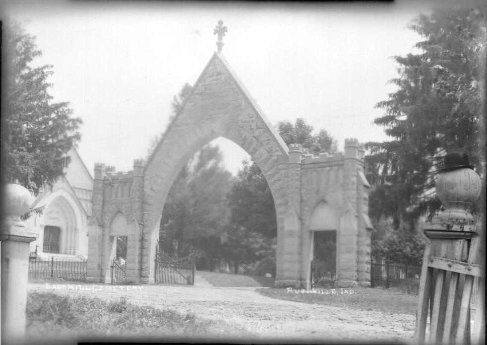
East Hill Cemetery
Monument and historic site · National Register of Historic Places · 1.1 mi
Cemetery in Rushville, Indiana, United States
John K. Gowdy House
Monument and historic site · National Register of Historic Places · 0.4 mi
Historic house in Indiana, United States
Melodeon Hall
Monument and historic site · National Register of Historic Places · 0.7 mi
Building in Indiana, United States of America
Rush County Courthouse
Monument and historic site · National Register of Historic Places · 0.7 mi
Courthouse in Indiana, United States
Rushville Commercial Historic District
Monument and historic site · National Register of Historic Places · 0.7 mi
Historic district in Indiana, United States
Wendell Lewis Willkie House
Monument and historic site · National Register of Historic Places · 0.4 mi
Historic house in Indiana, United States


Smith Covered Bridge
Bridge · National Register of Historic Places · 1.9 mi

Rush County Historical Society
Museum · 0.4 mi
619 North Perkins Street, Rushville
Parks, trails and playgrounds6

Restaurants and cafes16


Fish Moon Brewing Company
Bar and pub · 0.6 mi
309 North Main Street, Rushville
We-Th 16:00-21:00; Fr-Sa 12:00-23:00
Hardee’s
Restaurant · 0.9 mi
South Main Street
Mo-Th 05:00-22:00; Fr 05:00-23:00; Sa 06:00-23:00; Su 06:00-21:00


4 more on the map.
History
Rush County was formed from the unorganized Delaware County April 1, 1822. On July 29 town lots were sold and the town started to form. A school had already been started in 1821 by Dr. W.B. Laughlin, who was a member of the Legislature when the county was formed, and is considered the founding father of the town. A jail was built, Charles Veeder, was the first postmaster in 1822, and a courthouse was built in 1823. The Dog Fennel Gazette was published in 1823. The railroad was built in 1850 and after that a bank, factories, mills, and grain elevators sprang up.
Rushville was the campaign headquarters for Wendell Willkie's 1940 presidential campaign against Franklin Delano Roosevelt. Willkie is buried in the city's East Hill Cemetery.
The Durbin Hotel, John K. Gowdy House, Melodeon Hall, Rush County Courthouse, Rushville Commercial Historic District, St. Paul Methodist Episcopal Church, Booker T. Washington School, and Wendell Lewis Willkie House are listed on the National Register of Historic Places.
From the History section of Rushville, Indiana on Wikipedia, under CC BY-SA 4.0.
Where to stay2
Churches and places of worship4
St. Paul Methodist Episcopal Church
Church · National Register of Historic Places · 0.5 mi
Rushville Baptist Temple
Church · Baptist · 0.8 mi
1335 North Spencer Street, Rushville
Shopping4
Gas and EV charging1
Schools, colleges and libraries8
Healthcare2
Map of Rushville
56 places. The map loads OpenStreetMap tiles when you open it.
Climate by month
Monthly table
| Month | High | Low | Rain | Snow |
|---|---|---|---|---|
| Jan | 34°F | 19°F | 3.6 in | 6.2 in |
| Feb | 39°F | 22°F | 2.5 in | 3.4 in |
| Mar | 50°F | 30°F | 3.5 in | 2.8 in |
| Apr | 62°F | 40°F | 4.8 in | 0.0 in |
| May | 73°F | 52°F | 5.1 in | 0.0 in |
| Jun | 81°F | 61°F | 5.1 in | 0.0 in |
| Jul | 83°F | 64°F | 4.3 in | 0.0 in |
| Aug | 82°F | 62°F | 3.6 in | 0.0 in |
| Sep | 77°F | 54°F | 3.1 in | 0.0 in |
| Oct | 65°F | 43°F | 3.2 in | 0.1 in |
| Nov | 51°F | 33°F | 3.6 in | 0.3 in |
| Dec | 40°F | 25°F | 3.2 in | 3.1 in |
U.S. Climate Normals 1991-2020 for Rushville Hcn (1 mi away), NOAA NCEI.
People and cost of living
American Community Survey 5-year estimates, 2020-2024, U.S. Census Bureau. Estimates have margins of error, larger for small towns.
Disaster history
Rush County has had 11 federal disaster declarations since 2000, most often for severe storms.
- 2026-08-25: Severe Storms, Straight-Line Winds, Tornadoes, And Flooding (Flood)
- 2026-08-15: Severe Storms, Straight-Line Winds, Tornadoes, And Flooding (Flood)
- 2026-01-24: Severe Winter Storm (Winter Storm)
- 2020-04-03: Covid-19 Pandemic (Biological)
- 2020-03-13: Covid-19 (Biological)
- 2008-09-23: Severe Storms And Flooding (Severe Storm)
OpenFEMA disaster declarations summaries.
Getting there and nearby towns
Mettel Field Airport (CEV) is the nearest airport with scheduled flights listed in OpenStreetMap, 17 miles away.
- Knightstown 13 mi north, about 21 min by car
- Connersville 16 mi east, about 26 min by car
- Morristown 16 mi west, about 26 min by car
- Shelbyville 18 mi west, about 29 min by car
- Greensburg 19 mi south, about 30 min by car
- Cambridge City 20 mi northeast, about 32 min by car
- Greenfield 21 mi northwest, about 34 min by car
- New Castle 21 mi north, about 34 min by car
- Batesville 25 mi southeast, about 41 min by car
- New Palestine 25 mi west, about 40 min by car
Drive times are estimates from straight-line distance, not routes.
Local news
Headlines from INDB, the NEMICO news database.
Reviews, tips and questions
Loading what members have shared...
Sources and licences
- NCES EDGE (Public domain): public schools
- NOAA NCEI U.S. Climate Normals 1991-2020 (Public domain): climate by month
- OpenFEMA (Public domain): disaster declarations
- OpenStreetMap contributors (ODbL 1.0): places, airports, map data
- U.S. Census Bureau (Public domain): population, income, housing, education, commute
- Wikidata (CC0 1.0): elevation, founding date, time zone, website, landmarks and historic places
- Wikimedia Commons (see each image): photos
- Wikipedia (CC BY-SA 4.0): overview and history text
Photo credits
- Rushville-indiana-from-above2, Unknown author, Public domain
- John K. Gowdy House, Rushville, Nyttend, Public domain
- St. Paul Methodist Church, Rushville, Nyttend, Public domain
- Booker T. Washington School in Rushville, Nyttend, Public domain
- Rushville City Center 2019-12-05, RushvilleBrian, CC BY-SA 4.0
- Storm over Rushville, Smartin10, CC BY-SA 3.0
- Archibald M. Kennedy House, Nyttend, Public domain
- View of East Hill Cemetery entrance n.d. (3193616877), Snyder, Frank R. Flickr: Miami U. Libraries - Digital Collections, No restrictions
- Smith Covered Bridge, western portal, Nyttend, Public domain
- Wendell Lewis Willkie House, Nyttend, Public domain
- Durbin Hotel, Nyttend, Public domain
- Rville Farmers Market, RushvilleBrian, CC BY-SA 4.0
- Melodeon Hall and block, User:Nyttend, Public domain
- Melodeon Hall in 2009, Nyttend, Public domain
- Melodeon Hall, Jack Boucher, Public domain
- Norris Ford Covered Bridge, interior from east, Nyttend, Public domain
- Norris Ford Covered Bridge, eastern portal, Nyttend, Public domain
- Norris Ford Covered Bridge, interior from west, Nyttend, Public domain
- Norris Ford Covered Bridge, western portal, Nyttend, Public domain


Page built October 30, 2026. Spotted a mistake? Tell us or suggest a place.