
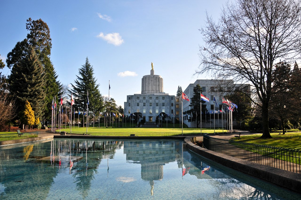


Salem, Oregon
Salem is a city of 178,865 people in Marion County, Oregon, founded in 1842.
Why visit Salem
Townapedia lists 83 museums and landmarks, 53 parks and trails, 285 places to eat, 11 places to stay and 16 attractions in and around town.
Highlights include Northern Lights Theatre Pub, Regal Willamette Town Center, Gilbert House Children's Museum and Hallie Ford Art Museum.
August is the warmest month, with average highs of 84°F; December lows average 35°F.
Weather in Salem
Forecast from the National Weather Service. Full forecast
About Salem
Salem is the capital city of the U.S. state of Oregon, and the county seat of Marion County. Founded in 1842, it is located in the center of the Willamette Valley alongside the Willamette River, which runs north through the city. The river forms the boundary between Marion and Polk counties, and the city neighborhood of West Salem is in Polk County.
From the Wikipedia article Salem, Oregon (this version), under CC BY-SA 4.0.
Things to do16


Center Street Bridge
Bridge · 1.8 mi
Bridge over the Willamette River in Salem, Oregon, U.S.

Corban University
School · 4.2 mi
Christian university in Salem, Oregon, U.S.

Enchanted Forest
Monument and historic site · 6.3 mi
Amusement park in Turner, Oregon, United States
L. B. Day Amphitheatre
Cinema and theater · 2.5 mi
Open-air concert venue in Salem, Oregon, United States of America
Marion Street Bridge
Bridge · 1.8 mi
Bridge in United States of America
Peter Courtney Minto Island Bridge
Bridge · 1.5 mi
Bicycle and pedestrian bridge in Salem, Oregon, U.S
Thrill-Ville USA
Monument and historic site · 6.3 mi
Former amusement park in Turner, Oregon, United States
4 more on the map.
Museums and landmarks83


Union Street Railroad Bridge
Monument and historic site · National Register of Historic Places · 1.8 mi
Bridge in West Salem, Oregon

Willamette Heritage Center
Museum · National Register of Historic Places · 0.8 mi
Museum in Salem, Oregon, U.S
1313 Mill Street Southeast, Salem
Tu-Sa 10:00-16:00

Deepwood Estate
Museum · National Register of Historic Places · 0.6 mi
Historic house museum in Salem, Oregon, USA
sunrise-sunset

Grand Theatre
Cinema and theater · National Register of Historic Places · 1.3 mi
Former movie theater in Salem, Oregon, United States
191 High Street Northeast, Salem

Mahonia Hall
Monument and historic site · National Register of Historic Places · 1.4 mi
Official residence of the governor, in Salem, Oregon, United States
533 Lincoln Street South, Salem

Old West Salem City Hall
Monument and historic site · National Register of Historic Places · 2.1 mi
Historic former city hall in Salem, Oregon, USA
1320 Edgewater Street Northwest, Salem

Oregon State Capitol
Monument and historic site · National Register of Historic Places · 1.1 mi
State capitol building of the U.S. state of Oregon
900 Court Street Northeast, Salem

Salem Downtown State Street – Commercial Street Historic District
Monument and historic site · National Register of Historic Places · 1.4 mi
Historic district in Salem, Oregon, USA


Waller Hall
Monument and historic site · National Register of Historic Places · 1.0 mi
Building at Willamette University, Salem, Oregon, USA
Adolph Block
Monument and historic site · National Register of Historic Places · 1.3 mi
Commercial building in Salem, Oregon
71 more on the map.
Parks, trails and playgrounds53

Riverfront Park
Park · 1.6 mi
Park in Salem, Oregon, USA
200 Water Street Northeast, Salem
sunrise-sunset

Geer Park
Park · 1.5 mi
Also often a wood debris drop-off during disasters
241 Geer Drive Northeast, Salem
41 more on the map.
Restaurants and cafes285


503 Sushi Bar
Restaurant · Japanese · 1.4 mi
189 Liberty Street Northeast, Salem
Mo,Su 11:30-20:00; Tu-We 16:00-21:00; Th-Sa 11:30-21:00

Chen’s Family Dish Six Wok & Bar
Restaurant · Chinese · 1.7 mi
3583 Commercial Street Southeast, Salem
Mo-Su 11:00-24:00
Damascus Kitchen
Restaurant · Arab, Kebab, Mediterranean · 1.3 mi
440 State Street, Salem
Mo-Sa 11:00-21:00

Flight Deck Restaurant & Lounge
Diner · American · 1.4 mi
2680 Aerial Way Southeast, Salem
Tu-Fr 11:00-21:00; Sa-Su 08:00-21:00; Mo closed "Staffing issues"
Fresh Elements
Restaurant · Vietnamese · 1.5 mi
364 Center Street Northeast, Salem
Mo,We-Fr 11:30-21:00; Sa-Su 12:00-21:00
Honey & Co.
Restaurant · Breakfast · 1.5 mi
250 Court Street Northeast, Salem
Mo-Sa 07:00-14:00; Su 08:00-14:00
273 more on the map.
History
Salem was founded in 1842, became the capital of the Oregon Territory in 1851, and was incorporated in 1857.
From the History section of Salem, Oregon on Wikipedia, under CC BY-SA 4.0.
Where to stay11
Holman Riverfront Park Hotel Salem, Tapestry Collection by Hilton
Motel and hotel · 1.4 mi
195 Commercial Street Southeast, Salem
Howard Johnson by Wyndham Salem
Motel and hotel
2250 Mission Street Southeast, Salem
Churches and places of worship21
Salem First United Methodist Church
Church · Methodist · National Register of Historic Places · 1.2 mi
600 State Street, Salem
Dasmesh Darbar Sikh Temple
Place of worship · 1.8 mi
860 Oakhill Avenue Southeast, Salem
Evergreen Church
Church · Presbyterian · 1.7 mi
905 Cottage Street Northeast, Salem
First Church of Christ, Scientist
Church · Christ Scientist · 1.1 mi
935 High Street Southeast, Salem
Saint Paul's Episcopal Church
Church · Episcopal · 1.0 mi
1444 Liberty Street Southeast, Salem
Salem Central Seventh-Day Adventist
Church · Seventh Day Adventist · 1.8 mi
1330 Summer Street Northeast, Salem
Shopping58
Gas and EV charging34
Fred Meyer fuel #355
Gas station · 1.6 mi
3415 Commercial Street Southeast, Salem
Schools, colleges and libraries64
Healthcare19
Lancaster Family Health Center at Lancaster
Clinic and pharmacy · 1.9 mi
255 Lancaster Drive Northeast, Salem
DaVita Dialysis
Clinic and pharmacy · 2.0 mi
421 Lancaster Drive Northeast, Salem
Passport Health Salem Travel Clinic
Clinic and pharmacy · 2.1 mi
3000 Market Street Northeast, Salem
Map of Salem
250 places. The map loads OpenStreetMap tiles when you open it.
Climate by month
Monthly table
| Month | High | Low | Rain |
|---|---|---|---|
| Jan | 48°F | 36°F | 6.1 in |
| Feb | 52°F | 36°F | 4.5 in |
| Mar | 57°F | 38°F | 4.3 in |
| Apr | 62°F | 41°F | 3.1 in |
| May | 69°F | 46°F | 2.2 in |
| Jun | 75°F | 51°F | 1.2 in |
| Jul | 84°F | 55°F | 0.2 in |
| Aug | 84°F | 55°F | 0.4 in |
| Sep | 78°F | 51°F | 1.5 in |
| Oct | 65°F | 44°F | 3.5 in |
| Nov | 54°F | 39°F | 6.0 in |
| Dec | 47°F | 35°F | 7.0 in |
U.S. Climate Normals 1991-2020 for Salem Mcnary Fld 72694 (2 mi away), NOAA NCEI.
People and cost of living
American Community Survey 5-year estimates, 2020-2024, U.S. Census Bureau. Estimates have margins of error, larger for small towns.
Disaster history
Marion County has had 11 federal disaster declarations since 2000, most often for fires.
- 2023-08-24: Liberty Fire (Fire)
- 2021-05-04: Severe Winter Storm (Severe Storm)
- 2020-09-15: Wildfires And Straight-Line Winds (Fire)
- 2020-09-10: Wildfires (Fire)
- 2020-09-08: Beachie Creek Lionshead Fire Complex (Fire)
- 2020-03-28: Covid-19 Pandemic (Biological)
OpenFEMA disaster declarations summaries.
Getting there and nearby towns
Salem - Willamette Valley Airport (SLE) is the nearest airport with scheduled flights listed in OpenStreetMap, 1 miles away.
- Four Corners 2 mi east, about 4 min by car
- Hayesville 5 mi northeast, about 7 min by car
- Keizer 5 mi north, about 9 min by car
- Turner 6 mi southeast, about 10 min by car
- Aumsville 9 mi southeast, about 15 min by car
- Independence 10 mi southwest, about 16 min by car
- Hillsboro 42 mi north, about 1 h by car
- Portland 46 mi northeast, about 1 h 15 min by car
- Gresham 49 mi northeast, about 1 h 15 min by car
- Vancouver 53 mi northeast, about 1 h 30 min by car
Drive times are estimates from straight-line distance, not routes.
Local news
Headlines from INDB, the NEMICO news database.
Reviews, tips and questions
Loading what members have shared...
Sources and licences
- NCES EDGE (Public domain): public schools
- NOAA NCEI U.S. Climate Normals 1991-2020 (Public domain): climate by month
- OpenFEMA (Public domain): disaster declarations
- OpenStreetMap contributors (ODbL 1.0): places, airports, map data
- U.S. Census Bureau (Public domain): population, income, housing, education, commute
- Wikidata (CC0 1.0): elevation, founding date, time zone, website, landmarks and historic places
- Wikimedia Commons (see each image): photos
- Wikipedia (CC BY-SA 4.0): overview and history text
Photo credits
- Oregon State Capitol, André Orso (6501975671), Oregon Department of Transportation, CC BY 2.0
- Salem Amtrak bus stop - Cascades POINT (20577559968), Oregon Department of Transportation, CC BY 2.0
- Salem Station Cascades POINT Route - Salem (31076227184), Oregon Department of Transportation, CC BY 2.0
- Cascades POINT leaving Salem en route to Portland (27303055702), Oregon Department of Transportation, CC BY 2.0
- Cascades POINT Route - Salem (31768412902), Oregon Department of Transportation, CC BY 2.0
- Cascades POINT Route - Salem (31768451642), Oregon Department of Transportation, CC BY 2.0
- Cascades POINT Route - Salem (31106599173), Oregon Department of Transportation, CC BY 2.0
- Cascades POINT Route - Salem (31878656236), Oregon Department of Transportation, CC BY 2.0
- Cascades POINT Route - Salem (31768518262), Oregon Department of Transportation, CC BY 2.0
- Cascades POINT Route - Salem (31107036223), Oregon Department of Transportation, CC BY 2.0
- POINT Cascades Route - Salem Amtrak Station (52488728732), Oregon Department of Transportation, CC BY 2.0
- Salem Amtrak bus stop - Cascades POINT (20142961164), Oregon Department of Transportation, CC BY 2.0
- Cascades POINT Route - Salem (31878576156), Oregon Department of Transportation, CC BY 2.0
- Salem Amtrak bus stop - Cascades POINT (20772493411), Oregon Department of Transportation, CC BY 2.0
- POINT Cascades Route - Salem Amtrak Station (52489771368), Oregon Department of Transportation, CC BY 2.0
- Salem Railroad Baggage Depot (8537339668), Oregon Department of Transportation, CC BY 2.0
- Salem Railroad Baggage Depot (8536236419), Oregon Department of Transportation, CC BY 2.0
- Salem Railroad Baggage Depot (8536236177), Oregon Department of Transportation, CC BY 2.0
- Salem Railroad Baggage Depot (8537339300), Oregon Department of Transportation, CC BY 2.0
- Salem Railroad Baggage Depot (8537339530), Oregon Department of Transportation, CC BY 2.0
- Salem Railroad Baggage Depot (8536236289), Oregon Department of Transportation, CC BY 2.0
- Salem Railroad Baggage Depot (8537339704), Oregon Department of Transportation, CC BY 2.0
- Salem Railroad Baggage Depot (8537339502), Oregon Department of Transportation, CC BY 2.0
- Salem Railroad Baggage Depot (8536236527), Oregon Department of Transportation, CC BY 2.0
- Salem Railroad Baggage Depot (8536236143), Oregon Department of Transportation, CC BY 2.0
- Salem Railroad Baggage Depot (8536236195), Oregon Department of Transportation, CC BY 2.0
- SALEM 1972 004 (49913360278), Robert Rynerson from Denver, U.S.A., CC BY 2.0
- 2026-03-04, Boon House (1847), Willamette Heritage Center (Salem, Oregon), 154829, Steven Pavlov, CC BY-SA 4.0
- 2026-03-04, Boon House (1847), Willamette Heritage Center (Salem, Oregon), 154920, Steven Pavlov, CC BY-SA 4.0
- 2026-03-04, Boon House (1847), Willamette Heritage Center (Salem, Oregon), 154930, Steven Pavlov, CC BY-SA 4.0
- SalemORMissionMill6, Unknown author, Public domain
- Union Street Railroad Bridge, Cjdaniel, CC BY-SA 3.0
- Waller Hall Willamette University - Salem Oregon, M.O. Stevens at en.wikipedia, Public domain
- Salem Oregon downtown State Street buildings, M.O. Stevens, Public domain
- United Methodist Salem Oregon corner, M.O. Stevens, Public domain
- Oregon State Capitol 1, M.O. Stevens, Public domain
- Chemeketa Lodge - Odd Fellows Buildings Salem Oregon, M.O. Stevens, Public domain
- OWSCH1, Katr67, Public domain
- Deepwood House Christmas, Valfontis, CC0
- T. A. Livesley House 90000684 Marion County, OR, Jon Roanhaus, CC BY-SA 3.0


Page built October 30, 2026. Spotted a mistake? Tell us or suggest a place.