


Why visit Sheridan
Townapedia lists 13 museums and landmarks, 18 parks and trails, 29 places to eat, 25 places to stay and 2 attractions in and around town.
Highlights include Centennial Cinema, Holy Name Catholic School, Mount View and Sheridan County Fairgrounds.
July is the warmest month, with average highs of 88°F; January lows average 12°F.
Weather in Sheridan
Forecast from the National Weather Service. Full forecast
About Sheridan
Sheridan is a city in the U.S. state of Wyoming and the county seat of Sheridan County. The city is located halfway between Yellowstone Park and Mount Rushmore by U.S. Route 14 and 16. It is the principal town of the Sheridan, Wyoming, Micropolitan Statistical Area which encompasses all of Sheridan County. The 2020 census put the city's population at 18,737, making it the sixth-most populous city in Wyoming.
From the Wikipedia article Sheridan, Wyoming (this version), under CC BY-SA 4.0.
Things to do2

Museums and landmarks13

Holy Name Catholic School
Monument and historic site · National Register of Historic Places · 0.6 mi
Historic school in Sheridan, Wyoming, USA

Mount View
Monument and historic site · National Register of Historic Places
Building in Wyoming, United States

Sheridan County Courthouse
Monument and historic site · National Register of Historic Places · 0.4 mi
Courthouse in Wyoming, United States
224 South Main Street, Sheridan

Sheridan Inn
Monument and historic site · National Register of Historic Places · 0.9 mi
Historic hotel in Wyoming


Robinson-Smith House
Monument and historic site · National Register of Historic Places · 0.4 mi

Sheridan County Fairgrounds Historic District
Monument and historic site · National Register of Historic Places · 1.0 mi
Historic district in Wyoming, United States
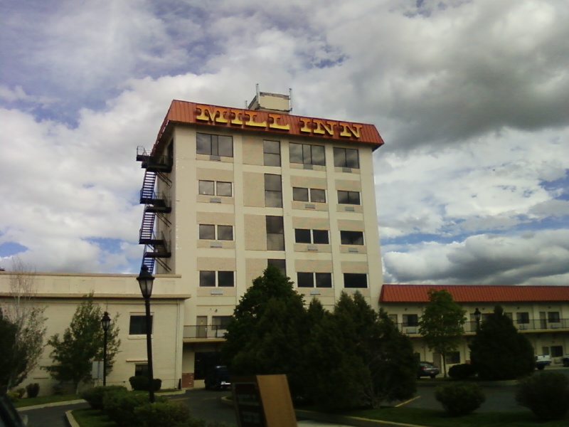
Sheridan Flouring Mills, Inc.
Monument and historic site · National Register of Historic Places · 1.9 mi
Hotel in Wyoming, United States of America
Sheridan Main Street Historic District
Monument and historic site · National Register of Historic Places · 0.5 mi
Historic district in Wyoming, United States
Sheridan Railroad Historic District
Monument and historic site · National Register of Historic Places · 0.8 mi
Historic district in Wyoming, United States
Sheridan Veterans Administration Medical Center
Monument and historic site · National Register of Historic Places · 2.3 mi
Veterans Administration hospital in Sheridan County, Wyoming, United States


Trail End
Monument and historic site · National Register of Historic Places · 0.4 mi
Building in Wyoming, United States
1 more on the map.
Parks, trails and playgrounds18

Sheridan County Fairgrounds
Park · 1.0 mi
1753 Victoria Street, Sheridan

Kendrick Municipal Golf Course
Golf course · 2.7 mi
65 Golf Course Road, Sheridan

6 more on the map.
Restaurants and cafes29



Cowboy Cafe
Restaurant · American, Burger · 0.4 mi
138 North Main Street
Th-Tu 07:00-20:00

17 more on the map.
History
The city was named after General Philip Sheridan, Union cavalry leader in the American Civil War.
Several battles between US Cavalry and the Sioux, Cheyenne, Arapaho, Shoshone, and Crow Indian tribes occurred in the area in the 1860s and 1870s before the town was built.
In 1878, trapper George Mandel built a cabin on Big Goose Creek, since reconstructed in the Whitney Commons park near the Sheridan County Fulmer Public Library. Jack Dow surveyed the townsite for Sheridan in 1882, at the behest of John Loucks, first mayor of the town who had served under Gen. Sheridan.
In the early 1880s, the nearby town of Big Horn was larger in population. In 1888, Sheridan County split off of Johnson County, and voters chose Sheridan as the county seat in a run-off election. The arrival of the Burlington and Missouri Railroad in 1892 boosted Sheridan's economic status, leading to the construction of the Sheridan Inn, where Buffalo Bill Cody was once a financial partner. Railroad maintenance facilities and railroad-tie treatment plants were significant employers in Sheridan's first decades. The railroad created numerous side industries as well as export opportunities for raw materials. Maps of the day show Sheridan as part of the "hinterland" providing raw goods to cities like Chicago. For the next twenty years the economy and population boomed.
From the History section of Sheridan, Wyoming on Wikipedia, under CC BY-SA 4.0.
Where to stay25
Fairfield Inn & Suites Sheridan;Fairfield Inn & Suites
Motel and hotel · 1.9 mi
2105 Sugarland Drive, Sheridan
Americas Best Value Inn Sheridan
Motel and hotel · 1.1 mi
580 5th Street, Sheridan
Churches and places of worship5
St. Peter's Episcopal Church
Church · National Register of Historic Places
Kingdom Hall of Jehovah's Witnesses
Church · Jehovahs Witness · 1.6 mi
2226 Big Horn Avenue, Sheridan
Shopping5
Gas and EV charging5
Schools, colleges and libraries20
Healthcare3
Hospital Pharmacy United Drugs
Clinic and pharmacy · 0.4 mi
1 South Main Street, Sheridan
Map of Sheridan
125 places. The map loads OpenStreetMap tiles when you open it.
Climate by month
Monthly table
| Month | High | Low | Rain |
|---|---|---|---|
| Jan | 36°F | 12°F | 0.6 in |
| Feb | 38°F | 14°F | 0.7 in |
| Mar | 49°F | 22°F | 1.0 in |
| Apr | 57°F | 30°F | 1.9 in |
| May | 66°F | 39°F | 2.7 in |
| Jun | 77°F | 47°F | 2.0 in |
| Jul | 88°F | 54°F | 1.1 in |
| Aug | 87°F | 52°F | 0.7 in |
| Sep | 76°F | 42°F | 1.5 in |
| Oct | 60°F | 31°F | 1.6 in |
| Nov | 47°F | 20°F | 0.8 in |
| Dec | 37°F | 12°F | 0.5 in |
U.S. Climate Normals 1991-2020 for Sheridan Co Ap Gsn 72666 (2 mi away), NOAA NCEI.
People and cost of living
American Community Survey 5-year estimates, 2020-2024, U.S. Census Bureau. Estimates have margins of error, larger for small towns.
Disaster history
Sheridan County has had 6 federal disaster declarations since 2000, most often for fires.
- 2024-09-30: Elk Fire (Fire)
- 2020-04-11: Covid-19 Pandemic (Biological)
- 2020-03-13: Covid-19 (Biological)
- 2011-07-22: Severe Storms, Flooding, And Landslides (Severe Storm)
- 2007-08-12: Little Goose Fire (Fire)
- 2003-11-20: Wy - Tongue River Wildfire - 11/19/2003 (Fire)
OpenFEMA disaster declarations summaries.
Getting there and nearby towns
Sheridan County Airport (SHR) is the nearest airport with scheduled flights listed in OpenStreetMap, 2 miles away.
- Powder Horn 7 mi south, about 12 min by car
- Ranchester 13 mi northwest, about 20 min by car
- Story 16 mi south, about 25 min by car
- Dayton 16 mi west, about 25 min by car
- Parkman 20 mi northwest, about 33 min by car
- Wyola 30 mi northwest, about 48 min by car
- Buffalo 34 mi south, about 55 min by car
- Lodge Grass 41 mi northwest, about 1 h by car
- Busby 50 mi north, about 1 h 15 min by car
- Muddy 55 mi north, about 1 h 30 min by car
Drive times are estimates from straight-line distance, not routes.
Local news
Headlines from INDB, the NEMICO news database.
Reviews, tips and questions
Loading what members have shared...
Sources and licences
- NCES EDGE (Public domain): public schools
- NOAA NCEI U.S. Climate Normals 1991-2020 (Public domain): climate by month
- OpenFEMA (Public domain): disaster declarations
- OpenStreetMap contributors (ODbL 1.0): places, airports, map data
- U.S. Census Bureau (Public domain): population, income, housing, education, commute
- Wikidata (CC0 1.0): elevation, founding date, time zone, website, landmarks and historic places
- Wikimedia Commons (see each image): photos
- Wikipedia (CC BY-SA 4.0): overview and history text
Photo credits
- Sheridan, Vasiliymeshko, CC BY-SA 3.0
- St. Peter's Episcopal Church NRHP 1300266 Sheridan County, WY ShiftN, Jon Roanhaus, CC BY-SA 3.0
- SHERIDAN COUNTY COURTHOUSE, JERRYE & ROY KLOTZ MD, CC BY-SA 3.0
- Sheridan - Sheridan Inn 13-09-2014 10-15-53, Paul Hermans, CC BY-SA 3.0
- Mount View NRHP 97001534 Sheridan County, WY, Jon Roanhaus, CC BY-SA 3.0
- Holy Name School NRHP 13000212 Sheridan County, WY, Jon Roanhaus, CC BY-SA 3.0
- Sheridan Flouring Mills & Mill Inn 2, Xnatedawgx, CC BY-SA 3.0
- Trail End State Historic Site aka Kendrick Mansion-Sheridan WY-06-28-2011, IreneWyo, CC BY-SA 3.0
- Robinson-Smith House, Sheridan, Wyoming, Drmccreedy, CC BY-SA 4.0
- Holy Name Catholic Church in Sheridan Wyoming, Always dreamin, CC0

Page built October 30, 2026. Spotted a mistake? Tell us or suggest a place.