
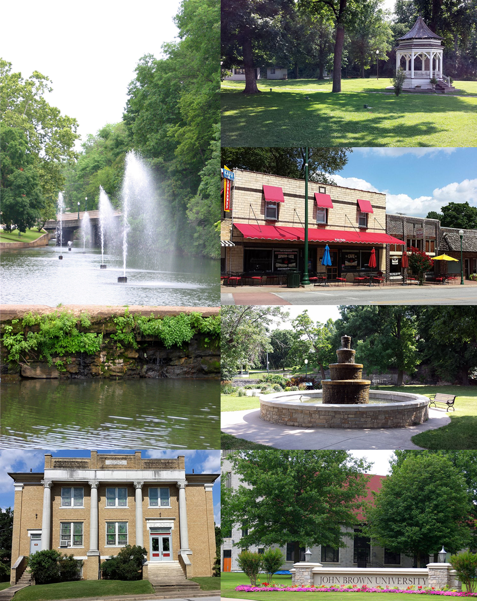


Siloam Springs, Arkansas
Siloam Springs is a city of 18,699 people in Benton County, Arkansas, founded in December 22, 1881.
Why visit Siloam Springs
Townapedia lists 25 museums and landmarks, 12 parks and trails, 69 places to eat, 9 places to stay and 3 attractions in and around town.
Highlights include John Brown University, Siloam Springs 6, Crown Hotel and Grand Army of the Republic Memorial.
July is the warmest month, with average highs of 91°F; January lows average 28°F.
Weather in Siloam Springs
Forecast from the National Weather Service. Full forecast
About Siloam Springs
Siloam Springs is a city in Benton County, Arkansas, United States, and located on the western edge of the Northwest Arkansas metropolitan area. As of the 2020 census, the population of the city was 17,287. The community was founded in 1882 and was characterized by the purported healing powers of the spring water feeding Sager Creek and trading with nearby Native American tribes. The city shares a border on the Arkansas–Oklahoma state line with the city of West Siloam Springs, Oklahoma, which is within the Cherokee Nation territory.
From the Wikipedia article Siloam Springs, Arkansas (this version), under CC BY-SA 4.0.
Things to do3

John Brown University
School · 1.6 mi
Private liberal arts college in Siloam Springs, Arkansas, United States

Siloam Springs 6
Cinema and theater · 1.5 mi
1102 South Carl Street, Siloam Springs
Museums and landmarks25

Crown Hotel
Monument and historic site · National Register of Historic Places · 0.7 mi
Hotel in Siloam Springs, United States of America
119 West University Street, Siloam Springs

Grand Army of the Republic Memorial
Monument and historic site · National Register of Historic Places · 0.6 mi
War memorial in Siloam Springs, Arkansas

Alfrey-Brown House
Monument and historic site · National Register of Historic Places · 0.9 mi
United States historic place

Bratt-Smiley House
Monument and historic site · National Register of Historic Places · 0.6 mi
Historic house in Arkansas, U.S

Carl's Addition Historic District
Monument and historic site · National Register of Historic Places · 0.7 mi
Historic district in Siloam Springs, Arkansas

Connelly-Harrington House
Monument and historic site · National Register of Historic Places · 0.6 mi
Historic house in Siloam Springs, Arkansas

Duckworth-Williams House
Monument and historic site · National Register of Historic Places · 0.7 mi
Siloam Springs, Arkansas, listed on the NRHP in Arkansas

First National Bank
Monument and historic site · National Register of Historic Places · 0.6 mi
Bank building in Siloam Springs, United States of America

Fred Bartell House
Monument and historic site · National Register of Historic Places · 0.5 mi
Historic house in Arkansas, United States

German Builder's House
Monument and historic site · National Register of Historic Places · 0.5 mi
Historic house in Arkansas, United States

Gypsy Camp Historic District
Monument and historic site · National Register of Historic Places · 5.1 mi
Former summer camp in Benton County, Arkansas

House at 305 E. Ashley
Monument and historic site · National Register of Historic Places · 0.4 mi
Historic house in Arkansas, United States
13 more on the map.
Parks, trails and playgrounds12


Siloam Springs City Park
Park · National Register of Historic Places · 0.7 mi
Park in Siloam Springs, United States of America


Siloam Springs Country Club
Golf course · 0.8 mi
801 North Country Club Road, Siloam Springs

Restaurants and cafes69

28 Springs
Restaurant · Fine Dining · 0.6 mi
100 East University Street, Siloam Springs
Mo-Sa 11:00-21:00

Pour Jon's
Cafe · Coffee Shop, Sandwich · 0.5 mi
516-2 East Main Street
Mo-Fr 07:00-18:00; Sa 08:00-18:00; Su 08:00-17:00

Cathy's Corner
Restaurant · Diner, Breakfast · 0.9 mi
1910 Highway 412 East, Siloam Springs
We-Su 06:00-14:00
Hunan Village
Restaurant · Asian · 1.2 mi
3402 Highway 412 East, Siloam Springs
Tu-Th 11:00-21:00; Fr-Sa 11:00-21:30; Su 11:00-21:00
Jim's Razorback Pizza
Restaurant · Pizza · 0.7 mi
2125 East Main Street, Siloam Springs

KILROY Public House
Bar and pub · Irish · 0.6 mi
111 North Broadway Street, Siloam Springs
Sam's Southern Eatery
Diner · American · 1.8 mi
4290 Highway 412 East, Siloam Springs
Angelino's Italian Restaurant
Restaurant · Italian · 0.8 mi
2001 Highway 412 West, Siloam Springs
Asian Chef
Restaurant · Chinese, Japanese, Sushi · 1.2 mi
315 Highway 412 West, Siloam Springs
57 more on the map.
History
Osage Indians were the known first inhabitants of the area. Siloam Springs' first white settlers were of German and Scots-Irish origin. Simon Sager is considered the founder of the town, then known as Hico.
In 2012, the city was named one of the 20 best small towns in America by Smithsonian magazine.
From the History section of Siloam Springs, Arkansas on Wikipedia, under CC BY-SA 4.0.
Where to stay9
America's Best Value Inn and Suites
Motel and hotel · 1.8 mi
1801 Highway 412 West, Siloam Springs
Budget Inn & Suites
Motel and hotel · 0.8 mi
2400 Highway 412 East, Siloam Springs
Churches and places of worship20
Community Christian Fellowship
Church · Nondenominational · 0.4 mi
525 South Lincoln Street, Siloam Springs
Outreach Center Church
Church · Nondenominational · 3.1 mi
21181;21189 Oak Ridge Road, Siloam Springs
Redeemer Presbyterian Church
Church · Presbyterian · 0.4 mi
540 East Twin Springs Street, Siloam Springs
Trinity Pentecostal Church of God
Church · Pentecostal · 1.5 mi
2450 South Lincoln Street, Siloam Springs
Saint Mary Catholic Church
Church · Roman Catholic · 0.7 mi
1998 Highway 412 East, Siloam Springs
Church of the Nazarene
Church · Nazarene · 1.5 mi
1700 South Carl Street, Siloam Springs
Eastgate Church of Christ
Church · Church Of Christ · 0.8 mi
1997 Highway 412 West, Siloam Springs
Shopping18
Gas and EV charging8
Schools, colleges and libraries17
Siloam Springs High School Conversion Charter
School · 1.0 mi
700 N Progress Ave, Siloam Springs
Siloam Springs Intermediate School
School · 1.1 mi
1500 N Mt Olive St, Siloam Springs
Healthcare5
Siloam Springs Community Clinic
Clinic and pharmacy · 0.7 mi
500 South Mount Olive Street, Siloam Springs
Jepson's Drug Store & Gift
Clinic and pharmacy · 0.7 mi
623 South Mount Olive Street, Siloam Springs
Map of Siloam Springs
186 places. The map loads OpenStreetMap tiles when you open it.
Climate by month
Monthly table
| Month | High | Low | Rain |
|---|---|---|---|
| Jan | 49°F | 28°F | 2.7 in |
| Feb | 55°F | 32°F | 2.6 in |
| Mar | 63°F | 41°F | 4.2 in |
| Apr | 72°F | 49°F | 5.2 in |
| May | 78°F | 57°F | 6.6 in |
| Jun | 86°F | 66°F | 4.9 in |
| Jul | 91°F | 70°F | 4.6 in |
| Aug | 91°F | 69°F | 3.7 in |
| Sep | 84°F | 61°F | 3.6 in |
| Oct | 73°F | 50°F | 4.5 in |
| Nov | 61°F | 40°F | 4.1 in |
| Dec | 52°F | 32°F | 3.4 in |
U.S. Climate Normals 1991-2020 for Kansas 2 Ne (14 mi away), rain and snow from Decatur 2.6 Ese, NOAA NCEI.
People and cost of living
American Community Survey 5-year estimates, 2020-2024, U.S. Census Bureau. Estimates have margins of error, larger for small towns.
Disaster history
Benton County has had 19 federal disaster declarations since 2000, most often for severe storms.
- 2026-01-24: Severe Winter Storm (Winter Storm)
- 2025-04-05: Severe Storms, Tornadoes, And Flooding (Severe Storm)
- 2024-05-30: Severe Storms, Straight-Line Winds, Tornadoes, And Flooding (Severe Storm)
- 2020-08-27: Hurricane Laura (Hurricane)
- 2020-04-03: Covid-19 Pandemic (Biological)
- 2020-03-13: Covid-19 (Biological)
OpenFEMA disaster declarations summaries.
Getting there and nearby towns
Smith Field (SLG) is the nearest airport with scheduled flights listed in OpenStreetMap, 2 miles away.
- West Siloam Springs 4 mi west, about 6 min by car
- Gentry 5 mi northeast, about 8 min by car
- Decatur 12 mi north, about 19 min by car
- Highfill 13 mi northeast, about 21 min by car
- Tontitown 16 mi east, about 26 min by car
- Elm Springs 16 mi east, about 26 min by car
- Centerton 17 mi northeast, about 28 min by car
- Farmington 19 mi southeast, about 30 min by car
- Bentonville 20 mi northeast, about 33 min by car
- Springdale 21 mi east, about 34 min by car
Drive times are estimates from straight-line distance, not routes.
Local news
Headlines from INDB, the NEMICO news database.
Reviews, tips and questions
Loading what members have shared...
Sources and licences
- NCES EDGE (Public domain): public schools
- NOAA NCEI U.S. Climate Normals 1991-2020 (Public domain): climate by month
- OpenFEMA (Public domain): disaster declarations
- OpenStreetMap contributors (ODbL 1.0): places, airports, map data
- U.S. Census Bureau (Public domain): population, income, housing, education, commute
- Wikidata (CC0 1.0): elevation, founding date, time zone, website, landmarks and historic places
- Wikimedia Commons (see each image): photos
- Wikipedia (CC BY-SA 4.0): overview and history text
Photo credits
- Siloam Springs collage, Brandonrush, CC BY-SA 4.0
- House at 305 E. Ashley, Siloam Springs, AR, Valis55, CC BY-SA 3.0
- Siloam Springs WWTP 001, Brandonrush, CC BY-SA 3.0
- Siloam Springs WWTP 003, Brandonrush, CC BY-SA 3.0
- Siloam Springs WWTP 002, Brandonrush, CC BY-SA 3.0
- Downtown Siloam Springs, AR 023, Brandonrush, CC BY-SA 4.0
- City Park, Siloam Springs, AR 002, Brandonrush, CC BY-SA 4.0
- Lakeside Hotel 001, Brandonrush, CC BY-SA 4.0
- Pyeatte House 001, Brandonrush, CC BY-SA 4.0
- Duckworth-Williams House 001, Brandonrush, CC BY-SA 4.0
- Downtown Siloam Springs, AR 006, Brandonrush, CC BY-SA 4.0
- Maxwell-Sweet House 001, Brandonrush, CC BY-SA 4.0
- Downtown Siloam Springs, AR 008, Brandonrush, CC BY-SA 4.0
- Downtown Siloam Springs, AR 007, Brandonrush, CC BY-SA 4.0
- 322 S Wright St, Siloam Springs, AR, Brandonrush, CC BY-SA 4.0
- Downtown Siloam Springs, AR 011, Brandonrush, CC BY-SA 4.0
- Gypsy Camp Historic District, main common area, Valis55, CC BY-SA 3.0
- Fred Bartell House 001, Brandonrush, CC BY-SA 4.0
- Downtown Siloam Springs, AR 013, Brandonrush, CC BY-SA 4.0
- Alfrey-Brown House 001, Brandonrush, CC BY-SA 4.0
- Quell House 001, Brandonrush, CC BY-SA 4.0
- Downtown Siloam Springs, AR 005, Brandonrush, CC BY-SA 4.0
- Downtown Siloam Springs, AR 010, Brandonrush, CC BY-SA 4.0
- CPKC meet-up, ConrailFan76, CC BY-SA 4.0
- Thurmond House, Valis55, CC BY-SA 3.0
- Kansas City Southern - Holiday Express 2009, Doug Wertman from Rogers, AR, USA, CC BY 2.0
- Reeves House, Valis55, CC BY-SA 3.0
- Split up, Andrew Joseph, CC BY-SA 3.0
- Simon Sager Cabin, Valis55, CC BY-SA 3.0
- Simon Sager Cabin, DAR Plaque, Valis55, CC BY-SA 3.0
- Simon Sager Cabin, Historic Plaque, Valis55, CC BY-SA 3.0
- Oak Hill Mausoleum, Valis55, CC BY-SA 3.0
- ISS052-E-76391 - View of Earth, Earth Science and Remote Sensing Unit , Lyndon B. Johnson Space Center, Public domain
- ISS052-E-76392 - View of Earth, Earth Science and Remote Sensing Unit , Lyndon B. Johnson Space Center, Public domain
- ISS052-E-76394 - View of Earth, Earth Science and Remote Sensing Unit , Lyndon B. Johnson Space Center, Public domain
- ISS052-E-76393 - View of Earth, Earth Science and Remote Sensing Unit , Lyndon B. Johnson Space Center, Public domain


Page built October 30, 2026. Spotted a mistake? Tell us or suggest a place.