


Why visit Sleepy Eye
Townapedia lists 5 museums and landmarks, 15 parks and trails, 7 places to eat, 3 places to stay and 1 attraction in and around town.
Highlights include Winona and St. Peter Freight Depot, Chief Sleepy Eye Statue, Sleepy Eye Baseball Park and Sleepy Eye Family Aquatic Center.
July is the warmest month, with average highs of 82°F; January lows average 7°F, and about 38 inches of snow fall in a normal year.
Weather in Sleepy Eye
Forecast from the National Weather Service. Full forecast
About Sleepy Eye
Sleepy Eye is a small city in rural Brown County, Minnesota, United States. The city is named after a famed local Dakota chief from the 1800s. The population was 3,452 at the 2020 census.
From the Wikipedia article Sleepy Eye, Minnesota (this version), under CC BY-SA 4.0.
Things to do1

Museums and landmarks5
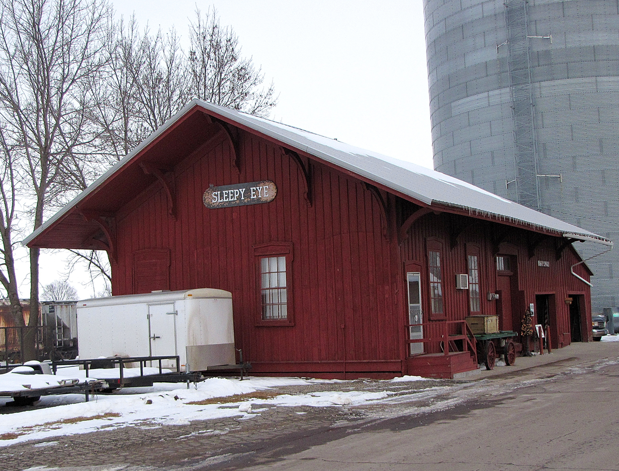


Winona and St. Peter Freight Depot
Monument and historic site · National Register of Historic Places
Historic building in Sleepy Eye, Minnesota, United States

Chief Sleepy Eye Statue
Monument and historic site
Monument marking the burial place of Dakota chief Iṡtaḣba ("Sleepy Eye"). The town of Sleepy Eye is named after him.

Ish Tak Ha Ba Monument
Monument and historic site
Historical marker describing the life of Dakota chief Iṡtaḣba ("Sleepy Eye"), who is buried nearby and who the town is named after.
Parks, trails and playgrounds15

Sleepy Eye Family Aquatic Center
Sports field and stadium · 0.6 mi
201 Burnside Street SE, Sleepy Eye



3 more on the map.
Restaurants and cafes7

Jimmy's Pizza
Restaurant · Pizza
136 Main Street W, Sleepy Eye
Mo-Fr 11:30-13:00, 16:00-21:00; Sa-Su 16:00-21:00

Railway Bar & Grill
Diner · American
300 1st Avenue North, Sleepy Eye

DQ Grill & Chill
Fast food · Ice Cream, Burger · 0.4 mi
617 Main Street West, Sleepy Eye
Mo-Fr 10:30-21:00,Sa-Su 11:00-21:00
Subway
Fast food · Sandwich
421 Main Street West, Sleepy Eye
Mo-Fr 07:00-21:30,Sa 08:00-21:30,Su 09:00-21:00
History
Sleepy Eye took its name from Sleepy Eye Lake, which was named after Chief Sleepy Eye, who was known as a compassionate person with droopy eyelids (or maybe just one). The chief was one of four Sioux Native Americans (four Ojibwe also attended) chosen to meet President James Monroe in 1824 in the nation's capital. Later, Sleepy Eye was an integral player in the 1851 signing of the Treaty of Traverse des Sioux, which gave all the land but a 10-mile swath on each side of the upper Minnesota River to the U.S. government. His recommendations to traders led to the successful settlement of Mankato, away from flood areas, and the chief eventually settled his people near the lake now known as Sleepy Eye Lake.
Sleepy Eye was platted in 1872 and incorporated as a city in 1903.
From the History section of Sleepy Eye, Minnesota on Wikipedia, under CC BY-SA 4.0.
Where to stay3
Churches and places of worship9
Grace Evangelical Lutheran Church
Church · Lutheran · 0.6 mi
710 4th Avenue SW, Sleepy Eye
Family Jubilee Shrine
Church · Roman Catholic · 0.7 mi
27762 County Road 27, Sleepy Eye
Shopping1
Gas and EV charging2
Schools, colleges and libraries7
Healthcare2
Map of Sleepy Eye
52 places. The map loads OpenStreetMap tiles when you open it.
Climate by month
Monthly table
| Month | High | Low | Rain | Snow |
|---|---|---|---|---|
| Jan | 24°F | 7°F | 0.7 in | 7.8 in |
| Feb | 29°F | 11°F | 0.9 in | 6.9 in |
| Mar | 41°F | 24°F | 1.6 in | 6.0 in |
| Apr | 57°F | 36°F | 2.9 in | 1.5 in |
| May | 69°F | 48°F | 4.1 in | 0.1 in |
| Jun | 79°F | 59°F | 5.0 in | 0.0 in |
| Jul | 82°F | 62°F | 4.1 in | 0.0 in |
| Aug | 80°F | 60°F | 3.7 in | 0.0 in |
| Sep | 73°F | 52°F | 3.3 in | 0.0 in |
| Oct | 60°F | 39°F | 2.4 in | 0.5 in |
| Nov | 43°F | 26°F | 1.5 in | 6.5 in |
| Dec | 28°F | 13°F | 0.9 in | 9.0 in |
U.S. Climate Normals 1991-2020 for New Ulm 2 Se Hcn (12 mi away), NOAA NCEI.
People and cost of living
American Community Survey 5-year estimates, 2020-2024, U.S. Census Bureau. Estimates have margins of error, larger for small towns.
Disaster history
Brown County has had 13 federal disaster declarations since 2000, most often for floods.
- 2024-06-28: Severe Storms And Flooding (Flood)
- 2020-04-07: Covid-19 Pandemic (Biological)
- 2020-03-13: Covid-19 (Biological)
- 2019-06-12: Severe Winter Storm, Straight-Line Winds, And Flooding (Flood)
- 2018-09-05: Severe Storms, Tornadoes, Straight-Line Winds, And Flooding (Flood)
- 2014-07-21: Severe Storms, Straight-Line Winds, Flooding, Landslides, And Mudslides (Flood)
OpenFEMA disaster declarations summaries.
Getting there and nearby towns
New Ulm Municipal Airport (ULM) is the nearest airport with scheduled flights listed in OpenStreetMap, 11 miles away.
- New Ulm 13 mi east, about 20 min by car
- Springfield 13 mi west, about 22 min by car
- Fairfax 16 mi north, about 26 min by car
- St. James 22 mi south, about 36 min by car
- Madelia 23 mi southeast, about 37 min by car
- Redwood Falls 25 mi northwest, about 40 min by car
- Mountain Lake 27 mi south, about 43 min by car
- North Mankato 35 mi east, about 56 min by car
- St. Peter 37 mi east, about 1 h by car
- Mankato 38 mi east, about 1 h by car
Drive times are estimates from straight-line distance, not routes.
Local news
Headlines from INDB, the NEMICO news database.
Reviews, tips and questions
Loading what members have shared...
Sources and licences
- NCES EDGE (Public domain): public schools
- NOAA NCEI U.S. Climate Normals 1991-2020 (Public domain): climate by month
- OpenFEMA (Public domain): disaster declarations
- OpenStreetMap contributors (ODbL 1.0): places, airports, map data
- U.S. Census Bureau (Public domain): population, income, housing, education, commute
- Wikidata (CC0 1.0): elevation, founding date, time zone, website, landmarks and historic places
- Wikimedia Commons (see each image): photos
- Wikipedia (CC BY-SA 4.0): overview and history text
Photo credits
- CBergHotel, Jatakuck, CC BY-SA 3.0
- RCPE MNAU, Sleepy Eye, Minn, Jerry Huddleston, CC BY 2.0
- Ish-tak-ha-ba Monument Sleepy Eye Minnesota (27752640114), Tony Webster from Minneapolis, Minnesota, United States, CC BY-SA 2.0
- Sleepy Eye, Minnesota - US Post Office (28299947646), Tony Webster from Minneapolis, Minnesota, CC BY-SA 2.0
- Sleepy Eye - Where the farm-to-food system begins (28314151706), Tony Webster from Minneapolis, Minnesota, CC BY-SA 2.0
- RCPE MNAU, Sleepy Eye, Minn. - Flickr - chief huddleston, Jerry Huddleston from Hampton, Minnesota, US, CC BY 2.0
- RCPE MNAU, Sleepy Eye, Minn. - Flickr - chief huddleston (cropped), Jerry Huddleston from Hampton, Minnesota, US, CC BY 2.0
- United States Post Office- Sleepy Eye, Minnesota 56085 (28332058826), Tony Webster from Minneapolis, Minnesota, CC BY-SA 2.0
- Sleepy Eye, chief_huddleston, CC BY 2.0
- PIX Theatre - "Vote Trump" - Sleepy Eye, Minnesota (28255583881), Tony Webster from Minneapolis, Minnesota, United States, CC BY-SA 2.0
- City Hall and Office of the City Clerk - Sleepy Eye, Minnesota (28066000620), Tony Webster from Minneapolis, Minnesota, CC BY-SA 2.0
- City of Sleepy Eye, Minnesota (28332179936), Tony Webster from Minneapolis, Minnesota, CC BY-SA 2.0
- City of Sleepy Eye Minnesota Municipal Offices (28262320792), Tony Webster from Minneapolis, Minnesota, United States, CC BY-SA 2.0
- Vines - Sleepy Eye MN Tony Webster Minnesota (28265188012), Tony Webster from Minneapolis, Minnesota, United States, CC BY-SA 2.0
- Sleepy Eye - 53145076091 (RCPE 3456), chief_huddleston, CC BY 2.0
- Sleepy Eye (53145076091) (RCPE 3456), chief_huddleston, CC BY 2.0
- Sleepy Eye - 53145076091, chief_huddleston, CC BY 2.0
- SleepyEyeFreightDepot, Jatakuck, CC BY-SA 3.0
- Always shoot the depot - 52222958569, chief_huddleston, CC BY 2.0
- ISS047-E-78691 - View of Earth, Earth Science and Remote Sensing Unit , Lyndon B. Johnson Space Center, Public domain


Page built October 30, 2026. Spotted a mistake? Tell us or suggest a place.