


South Coventry, Connecticut
South Coventry is a community of 1,434 people in Connecticut.
Why visit South Coventry
Townapedia lists 11 museums and landmarks, 23 parks and trails and 7 places to eat in and around town.
Highlights include Captain Nathan Hale Monument and Brigham's Tavern.
July is the warmest month, with average highs of 80°F; January lows average 19°F, and about 39 inches of snow fall in a normal year.
Weather in South Coventry
Forecast from the National Weather Service. Full forecast
About South Coventry
South Coventry is a census-designated place and part of the town of Coventry, Connecticut, United States. The population was 1,483 at the 2010 census.
From the Wikipedia article South Coventry (CDP), Connecticut (this version), under CC BY-SA 4.0.
Museums and landmarks11

Captain Nathan Hale Monument
Monument and historic site · National Register of Historic Places · 0.8 mi
Monument in Connecticut, United States of America

Brigham's Tavern
Monument and historic site · National Register of Historic Places · 3.0 mi
Historic tavern in Connecticut, United States

Capron-Phillips House
Monument and historic site · National Register of Historic Places · 0.7 mi
Historic house in Connecticut, United States

Elias Sprague House
Monument and historic site · National Register of Historic Places · 2.1 mi
Coventry, Connecticut, listed on the NRHP in Tolland County

Mansfield Training School and Hospital
Monument and historic site · National Register of Historic Places · 3.4 mi
Former hospital

Nathan Hale Homestead
Museum · National Register of Historic Places · 2.4 mi
Historic house in Connecticut, United States

Parker-Hutchinson Farm
Monument and historic site · National Register of Historic Places · 1.6 mi
Building in Connecticut, United States
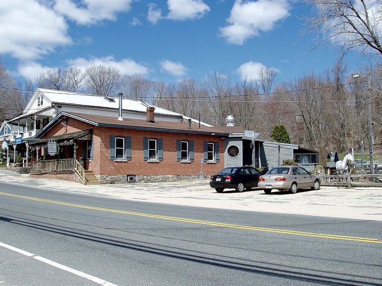
South Coventry Historic District
Monument and historic site · National Register of Historic Places · 0.9 mi
Human settlement in Connecticut, United States of America

Strong House
Monument and historic site · National Register of Historic Places · 2.5 mi
Historic house in Connecticut, United States

Willimantic Elks Club
Monument and historic site · National Register of Historic Places · 3.5 mi
Clubhouse in Connecticut, United States of America
Parks, trails and playgrounds23


Main Street Open Space
Hiking and trails · 1.5 mi
Town Open Space (Plains Road); Municipal, Open To Public Without Fee
11 more on the map.
Restaurants and cafes7

Bidwell Tavern Cafe
Bar and pub · 0.8 mi
1260 Main Street, Coventry
Su-Fr 11:00-21:00, We-Sa 11:00-22:00


Churches and places of worship3


St. Mary's Church
Church · 1.5 mi
Church building in Connecticut, United States of America

First Congregational Church of Coventry
Church · United Church Of Christ · 0.8 mi
Saint Mary Catholic Church
Church · Roman Catholic · 1.5 mi
1600 Main Street, Coventry
Gas and EV charging1
Schools, colleges and libraries21
Arts At The Capitol Theater Magnet School (Act)
School · 5.4 mi
896 Main Street, Willimantic
Map of South Coventry
66 places. The map loads OpenStreetMap tiles when you open it.
Climate by month
Monthly table
| Month | High | Low | Rain | Snow |
|---|---|---|---|---|
| Jan | 35°F | 19°F | 3.6 in | 8.3 in |
| Feb | 37°F | 20°F | 3.0 in | 14.1 in |
| Mar | 45°F | 28°F | 4.4 in | 6.3 in |
| Apr | 57°F | 38°F | 4.2 in | 1.7 in |
| May | 68°F | 48°F | 3.7 in | 0.0 in |
| Jun | 76°F | 57°F | 4.5 in | 0.0 in |
| Jul | 80°F | 63°F | 4.0 in | 0.0 in |
| Aug | 79°F | 61°F | 4.3 in | 0.0 in |
| Sep | 73°F | 54°F | 4.5 in | 0.0 in |
| Oct | 61°F | 43°F | 4.6 in | 0.3 in |
| Nov | 50°F | 34°F | 3.9 in | 1.1 in |
| Dec | 40°F | 25°F | 4.5 in | 7.2 in |
U.S. Climate Normals 1991-2020 for Storrs Hcn (5 mi away), NOAA NCEI.
People and cost of living
American Community Survey 5-year estimates, 2020-2024, U.S. Census Bureau. Estimates have margins of error, larger for small towns.
Disaster history
The county has had 21 federal disaster declarations since 2000, most often for hurricanes.
- 2021-08-22: Hurricane Henri (Hurricane)
- 2021-01-12: Tropical Storm Isaias (Hurricane)
- 2020-08-06: Tropical Storm Isaias (Hurricane)
- 2020-03-28: Covid-19 Pandemic (Biological)
- 2020-03-13: Covid-19 (Biological)
- 2015-04-08: Severe Winter Storm And Snowstorm (Severe Storm)
OpenFEMA disaster declarations summaries.
Getting there and nearby towns
Hartford–Brainard Airport (HFD) is the nearest airport with scheduled flights listed in OpenStreetMap, 18 miles away.
- Coventry Lake 2 mi northwest, about 4 min by car
- Storrs 4 mi northeast, about 7 min by car
- Willimantic 5 mi southeast, about 9 min by car
- South Windham 8 mi southeast, about 13 min by car
- Manchester 11 mi west, about 18 min by car
- Rockville 11 mi northwest, about 17 min by car
- Colchester 12 mi south, about 20 min by car
- Crystal Lake 13 mi north, about 21 min by car
- Stafford Springs 15 mi north, about 23 min by car
- East Hartford 16 mi west, about 25 min by car
Drive times are estimates from straight-line distance, not routes.
Local news
Headlines from INDB, the NEMICO news database.
Reviews, tips and questions
Loading what members have shared...
Sources and licences
- NCES EDGE (Public domain): public schools
- NOAA NCEI U.S. Climate Normals 1991-2020 (Public domain): climate by month
- OpenFEMA (Public domain): disaster declarations
- OpenStreetMap contributors (ODbL 1.0): places, airports, map data
- U.S. Census Bureau (Public domain): population, income, housing, education, commute
- Wikidata (CC0 1.0): elevation, founding date, time zone, website, landmarks and historic places
- Wikimedia Commons (see each image): photos
- Wikipedia (CC BY-SA 4.0): overview and history text
Photo credits
- PostcardCoventryCTKingsburyBoxAndPrintingCo1905, Not known, no information is printed on either side of postcard, Public domain
- Little Free Library, George Hersey Robertson School, South Coventry CT, John Phelan, CC BY-SA 4.0
- Streetcar at South Coventry schoolhouse - postcard, Unknown author Unknown author, Public domain
- Booth and Dimock Memorial Library, South Coventry CT, John Phelan, CC BY 4.0
- Coventry Arts and Antiques, South Coventry CT, John Phelan, CC BY 4.0
- First Congregational Church of Coventry, South Coventry CT, John Phelan, CC BY 4.0
- Bidwell Spirit Shoppe, South Coventry CT, John Phelan, CC BY 4.0
- Woke Breakfast and Coffee, South Coventry CT, John Phelan, CC BY 4.0
- Brighams Tavern, Coventry CT, John Phelan, CC BY-SA 3.0
- The Knight Hospital, Flickr user reivax, CC BY-SA 2.0
- Capron-Phillips House, Coventry CT, Jerry Dougherty, CC BY 2.5
- Elks Lodge, Willimantic, CT, FutureHistory, CC BY-SA 3.0
- Elias Sprague House, under renovation, Coventry CT, John Phelan, CC BY-SA 3.0
- Strong House, Sphilbrick, CC BY-SA 3.0
- Nathan Hale Homestead, Sphilbrick, CC BY-SA 3.0
- Bidwell Tavern, Coventry CT, Jerry Dougherty, CC BY 2.5
- CoventryCT ParkerHutchinsonFarm, Magicpiano, CC BY-SA 3.0
- St Marys Church, Coventry CT, John Phelan, CC BY 4.0
- CoventryCT CapronPhillipsHouse, Magicpiano, CC BY-SA 4.0
- 1992 Subaru Sambar Truck SDX 4WD in Polar White, front left, Mr.choppers, CC BY-SA 3.0
- 1992 Daihatsu Hijet Jumbo 4WD in White, front left, Mr.choppers, CC BY-SA 3.0
- 1994 Honda Today Ji 2-door in Frost White, rear right, Mr.choppers, CC BY-SA 3.0
- 1994 Honda Today Ji 2-door in Frost White, front left, Mr.choppers, CC BY-SA 3.0
- 1996 Suzuki Wagon R RV Turbo in Midnight Black, rear right, Mr.choppers, CC BY-SA 3.0
- 1996 Suzuki Wagon R RV Turbo in Midnight Black, rear left side, Mr.choppers, CC BY-SA 3.0
- 1996 Suzuki Wagon R RV Turbo in Midnight Black, front left, Mr.choppers, CC BY-SA 3.0
- 1996 Suzuki Wagon R RV Turbo in Midnight Black, front right, Mr.choppers, CC BY-SA 3.0
- 1988 Suzuki Every Wagon Turbo EX in Polar White, front right, Mr.choppers, CC BY-SA 3.0
- 1988 Suzuki Every Wagon Turbo EX in Polar White, rear right, Mr.choppers, CC BY-SA 3.0
- 1993 Subaru Vivio RX-R in Vivienne Red, front right, Mr.choppers, CC BY-SA 3.0
- 1993 Subaru Vivio RX-R in Vivienne Red, rear right, Mr.choppers, CC BY-SA 3.0
- 1996 Suzuki Cervo Mode M-selection in Scuba Blue, front left, Mr.choppers, CC BY-SA 3.0
- 1996 Suzuki Cervo Mode M-selection in Scuba Blue, rear left, Mr.choppers, CC BY-SA 3.0
- 1996 Suzuki Cervo Mode M-selection in Scuba Blue, dashboard, Mr.choppers, CC BY-SA 3.0
- CoventryCT SouthCoventryHD 2, Magicpiano, CC BY-SA 4.0
- CoventryCT SouthCoventryHD 1, Magicpiano, CC BY-SA 4.0
- Coventry Country Market, Coventry CT, John Phelan, CC BY-SA 4.0
- 1994 Daihatsu Hijet Climber truck in Blue, front left, Mr.choppers, CC BY-SA 3.0
- 1990 Suzuki Carry KA 4WD in Polar White, front left, Mr.choppers, CC BY-SA 3.0
- 1996 Daihatsu Opti Pico Limited in Dk Green Mica Met, rear right, Mr.choppers, CC BY-SA 3.0


Page built October 30, 2026. Spotted a mistake? Tell us or suggest a place.