


St. Albans, Vermont
St. Albans is a city of 6,954 people in Franklin County, Vermont, founded in 1783.
Why visit St. Albans
Townapedia lists 15 museums and landmarks, 7 parks and trails, 12 places to eat, 3 places to stay and 2 attractions in and around town.
Highlights include Aldis Hill, Evarts-McWilliams House, Fairfield Street School and Aldis Hill Park.
July is the warmest month, with average highs of 79°F; January lows average 8°F, and about 80 inches of snow fall in a normal year.
Weather in St. Albans
Forecast from the National Weather Service. Full forecast
About St. Albans
St. Albans or Saint Albans is the only city in and the shire town of Franklin County, Vermont, United States. At the 2020 census, the city population was 6,877. St. Albans City is completely surrounded by Saint Albans Town, which is a separate municipality. The city is in Northwestern Vermont, approximately 15 miles south of the Canadian border and 30 miles north of Burlington.
From the Wikipedia article St. Albans (city), Vermont (this version), under CC BY-SA 4.0.
Things to do2


Museums and landmarks15

Evarts-McWilliams House
Monument and historic site · National Register of Historic Places · 3.5 mi
Building in Vermont, United States

Fairfield Street School
Monument and historic site · National Register of Historic Places
School building in St. Albans, United States of America

Giroux Furniture Company Building
Monument and historic site · National Register of Historic Places
Building in Vermont, United States

Hathaway's Tavern
Monument and historic site · National Register of Historic Places · 0.8 mi
Building in Vermont, United States

Houghton House
Monument and historic site · National Register of Historic Places
Building in Vermont, United States

L'Ecole Saintes-Anges
Monument and historic site · National Register of Historic Places · 0.5 mi
Building in Vermont, United States

St. Albans Historic District
Monument and historic site · National Register of Historic Places
Historic district in Vermont, United States

St. Albans Town Hall
Monument and historic site · National Register of Historic Places · 2.7 mi
Rathaus in Vermont, United States of America

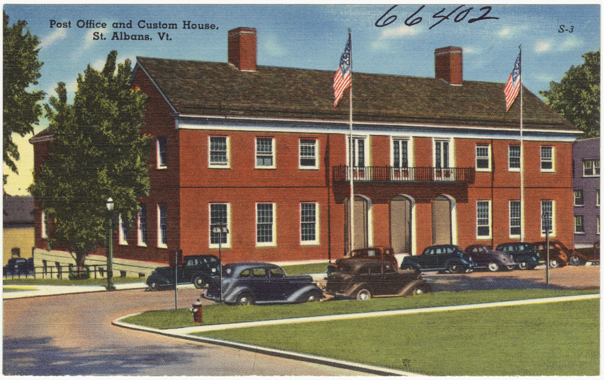
United States Post Office and Custom House
Monument and historic site · National Register of Historic Places · 0.8 mi
Historic government building at 40 South Main Street in the city of St. Albans, Vermont

Warner Home
Monument and historic site · National Register of Historic Places · 0.6 mi
Orphanage in St. Albans, Vermont


Willard Manufacturing Company Building
Monument and historic site · National Register of Historic Places
Building in Vermont, United States
Central Vermont Railroad Headquarters
Monument and historic site · National Register of Historic Places
3 more on the map.
Parks, trails and playgrounds7



Restaurants and cafes12


Maple City Diner
Diner · American · 1.0 mi
17 Swanton Road, Saint Albans
We-Sa 07:00-21:00; Su-Mo 07:00-15:00

Red House Sweets
Bakery
Bakery attached to Catalyst Coffee
10 Lake Street, Saint Albans
Tu-Fr 07:00-14:00; Sa 08:00-14:00

14th Star Brewing Co.
Bar and pub
133 North Main Street, St Albans
Tu-We 16:00-22:00; Th-Sa 11:00-22:00; Su 11:00-20:00
Mill River Brewing BBQ & Smokehouse
Bar and pub · 1.0 mi
10 Beauregard Drive, Saint Albans
We-Th 11:00-20:00; Fr-Sa 11:00-21:00; Su 12:00-19:00
Groennfell Meadery
Bar and pub · 1.1 mi
650 Industrial Park Road, Saint Albans
Sa 12:00-18:00
Havoc Mead
Bar and pub · 1.1 mi
650 Industrial Park Road, Saint Albans
Sa 12:00-18:00


Domino's
Fast food · Pizza · 0.8 mi
266 North Main Street, Saint Albans
Mo-Th 10:30-24:00; Fr-Sa 10:30-01:00; Su 10:30-24:00
History
One of the New Hampshire grants, St. Albans was chartered by Colonial Governor Benning Wentworth on August 17, 1763, to Stephen Pomeroy and 63 others. Named after St Albans, Hertfordshire, England, it was first settled during the Revolution by Jesse Welden. The war delayed further settlement until 1785, when other pioneers began to arrive from lower New England.
Farmers found the rich, dark loam suitable for cultivation, as well as for the raising of cattle, horses and sheep. Butter and cheese were produced in great quantities. St. Albans also became known as " The Rail City," home to a major depot, operations center and repair shop of the Vermont and Canada Railroad. When the village was incorporated in 1859, it had an iron foundry, a manufacturer of freight cars, and a large number of mechanic shops.
The northernmost engagement of the Civil War, known as the St. Albans Raid, occurred here on October 19, 1864.
In 1869 the Congrégation de Notre Dame, founded in Montreal, Quebec, in the 17th century, established Villa Barlow Convent and St. Mary High School in St. Albans.
In 1902, the City of St. Albans was incorporated, comprising two square miles (518 hectares) within the town of St. Albans. Today it is a tourist destination noted for its Victorian and Craftsman style architecture. Much of this was built during the railroad era, when more than 200 trains passed through daily.
From the History section of St. Albans (city), Vermont on Wikipedia, under CC BY-SA 4.0.
Where to stay3
Churches and places of worship9
Immaculate Conception (St Mary's)
Church · Roman Catholic
45 Fairfield Street, Saint Albans
Shopping3
Gas and EV charging3
Schools, colleges and libraries14
Georgia Elementary & Middle School
School · 5.5 mi
4416 Ethan Allen Highway, Saint Albans
St. Albans City Elementary School
School · 0.7 mi
29 Bellows Street, Saint Albans
Healthcare2
Cobblestone Health Commons
Clinic and pharmacy · 0.7 mi
260 Crest Road, Saint Albans
Map of St. Albans
70 places. The map loads OpenStreetMap tiles when you open it.
Climate by month
Monthly table
| Month | High | Low | Rain | Snow |
|---|---|---|---|---|
| Jan | 25°F | 8°F | 2.1 in | 16.9 in |
| Feb | 28°F | 10°F | 1.9 in | 18.3 in |
| Mar | 37°F | 20°F | 2.6 in | 16.2 in |
| Apr | 52°F | 33°F | 3.2 in | 6.2 in |
| May | 66°F | 46°F | 3.2 in | 0.1 in |
| Jun | 74°F | 56°F | 4.1 in | 0.0 in |
| Jul | 79°F | 61°F | 4.1 in | 0.0 in |
| Aug | 77°F | 59°F | 3.7 in | 0.0 in |
| Sep | 69°F | 51°F | 3.9 in | 0.0 in |
| Oct | 56°F | 40°F | 3.9 in | 1.2 in |
| Nov | 44°F | 30°F | 2.9 in | 5.0 in |
| Dec | 32°F | 18°F | 2.6 in | 16.0 in |
U.S. Climate Normals 1991-2020 for St Albans Radio (3 mi away), NOAA NCEI.
People and cost of living
American Community Survey 5-year estimates, 2020-2024, U.S. Census Bureau. Estimates have margins of error, larger for small towns.
Disaster history
Franklin County has had 21 federal disaster declarations since 2000, most often for severe storms.
- 2024-08-08: Tropical Depression Debby (Tropical Storm)
- 2024-04-19: Severe Winter Storm (Severe Storm)
- 2023-07-14: Severe Storms, Flooding, Landslides, And Mudslides (Flood)
- 2023-07-10: Flooding (Flood)
- 2023-03-20: Severe Storm And Flooding (Severe Storm)
- 2021-08-22: Tropical Storm Henri (Hurricane)
OpenFEMA disaster declarations summaries.
Getting there and nearby towns
Rouses Point Seaplane Base (RSX) is the nearest airport with scheduled flights listed in OpenStreetMap, 19 miles away.
- Fairfax 10 mi south, about 17 min by car
- Milton 13 mi south, about 20 min by car
- Enosburg Falls 15 mi northeast, about 25 min by car
- Cumberland Head 17 mi southwest, about 27 min by car
- Rouses Point 18 mi northwest, about 30 min by car
- Plattsburgh 20 mi southwest, about 32 min by car
- Champlain 21 mi northwest, about 34 min by car
- Essex Junction 22 mi south, about 36 min by car
- Jericho 22 mi south, about 35 min by car
- Burlington 23 mi south, about 38 min by car
Drive times are estimates from straight-line distance, not routes.
Local news
Headlines from INDB, the NEMICO news database.
Reviews, tips and questions
Loading what members have shared...
Sources and licences
- NCES EDGE (Public domain): public schools
- NOAA NCEI U.S. Climate Normals 1991-2020 (Public domain): climate by month
- OpenFEMA (Public domain): disaster declarations
- OpenStreetMap contributors (ODbL 1.0): places, airports, map data
- U.S. Census Bureau (Public domain): population, income, housing, education, commute
- Wikidata (CC0 1.0): elevation, founding date, time zone, website, landmarks and historic places
- Wikimedia Commons (see each image): photos
- Wikipedia (CC BY-SA 4.0): overview and history text
Photo credits
- CityHallWeldenTheatreStAlbansVT, Travellers & Tinkers, CC BY-SA 4.0
- Greetings from St. Albans, Vermont - Large Letter Postcard (52679456402), Steve Shook from Moscow, Idaho, USA, CC BY 2.0
- Regatta on Lake Champlain, St. Albans Bay, Vt. (2381935244), Boston Public Library, CC BY 2.0
- A corner of Taylor Park, St. Albans, Vt. (2381930212), Boston Public Library, CC BY 2.0
- Bellows Free Academy, St. Albans, Vt. (2381932400), Boston Public Library, CC BY 2.0
- Post Office and Customs House, St. Albans, Vt. (2381098493), Boston Public Library, CC BY 2.0
- Villa Barlow Convent, St. Mary's School, St. Albans, Vt. Hospital (2381933256), Boston Public Library, CC BY 2.0
- Old Grist Mill (built early 1800), St. Albans Bay, Vt. (2381934026), Boston Public Library, CC BY 2.0
- Air view of St. Albans, Vt. (2381933626), Boston Public Library, CC BY 2.0
- St. Albans, Vermont -- "Maple Syrup Capital of U.S." (2381101833), Boston Public Library, CC BY 2.0
- St. Albans Bay, Vt. on Lake Champlain from Hathaway Point, Vt. (2381103081), Boston Public Library, CC BY 2.0
- Fountain and Taylor Park, St. Albans, Vt. (2381931110), Boston Public Library, CC BY 2.0
- St. Mary's Church and Rectory, St. Albans, Vt. (2381103865), Boston Public Library, CC BY 2.0
- Kerbs Memorial Hospital, St. Albans, Vt. (2381935656), Boston Public Library, CC BY 2.0
- Soldiers and Sailors Memorial & Court House, St. Albans, Vt. (2381936438), Boston Public Library, CC BY 2.0
- Lake Champlain from Tower-Bellevue Hill, St. Albans, Vt. (2381932830), Boston Public Library, CC BY 2.0
- Main Street looking north, St. Albans, Vt. (2381104293), Boston Public Library, CC BY 2.0
- Bathing Beach at State Park, St. Albans Bay, Vt. (2381104713), Boston Public Library, CC BY 2.0
- World War Memorial, St. Albans, Vt. (2381930714), Boston Public Library, CC BY 2.0
- The Armory, St. Albans, Vt. (2381101431), Boston Public Library, CC BY 2.0
- Main Street, looking south, St. Albans, Vt. (2381098933), Boston Public Library, CC BY 2.0
- Interior panorama of St. Albans station, October 2018, LunchboxLarry, CC BY 2.0
- Evarts-McWilliams House StAlbans Vermont, Mfwills, CC BY-SA 3.0
- HathawaysTavern, Mfwills, CC BY-SA 3.0
- WarnerHome, Mfwills, CC BY-SA 3.0
- EcoleSainteAnges, Mfwills, CC BY-SA 3.0
- StAHistDist, Mfwills, CC BY-SA 3.0
- HoughtonHouse, Mfwills, CC BY-SA 3.0
- WillardMfg, Mfwills, CC BY-SA 3.0
- StATownHall, Mfwills, CC BY-SA 3.0
- FairfieldStSchool, Mfwills, CC BY-SA 3.0
- GirouxFurniture, Mfwills, CC BY-SA 3.0
- Street View St Albans Vermont (44418964704), LunchboxLarry, CC BY 2.0
- Amtrak Vermonter at St Albans, October 2018, LunchboxLarry, CC BY 2.0
- Court House 3, Californiapadre, CC BY-SA 4.0
- Cub scouts in vermont, BostonTx, CC BY 2.0
- St Albans VT 11-17-25, Ascended Dreamer, CC BY-SA 4.0
- ISS011-E-5841 - View of New York, Earth Science and Remote Sensing Unit , Lyndon B. Johnson Space Center, Public domain


Page built October 30, 2026. Spotted a mistake? Tell us or suggest a place.