


St. Georges, Delaware
St. Georges is a community of 1,530 people in New Castle County, Delaware.
Why visit St. Georges
Townapedia lists 33 museums and landmarks, 1 park or trail, 1 place to eat, 1 place to stay and 2 attractions in and around town.
Highlights include Liston Range Rear Light, Chesapeake & Delaware Canal Lift Bridge, Bloomfield and Ethel S. Roy House.
July is the warmest month, with average highs of 87°F; January lows average 26°F, and about 20 inches of snow fall in a normal year.
Weather in St. Georges
Forecast from the National Weather Service. Full forecast
About St. Georges
Saint Georges is an unincorporated community, former municipality, and census-designated place (CDP) situated on the Chesapeake and Delaware Canal in New Castle County, Delaware, United States, approximately midway between the Delaware River and the Chesapeake Bay.
From the Wikipedia article Saint Georges, Delaware (this version), under CC BY-SA 4.0.
Things to do2
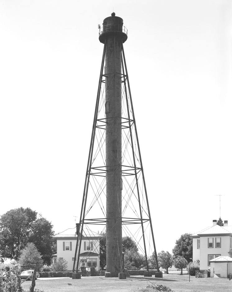
Liston Range Rear Light
Lighthouse · National Register of Historic Places · 2.5 mi
Lighthouse in Delaware, United States

Chesapeake & Delaware Canal Lift Bridge
Bridge · 3.1 mi
Bridge in Delaware, United States
Museums and landmarks33

Bloomfield
Monument and historic site · National Register of Historic Places · 0.5 mi
Building in Delaware, United States

Ethel S. Roy House
Monument and historic site · National Register of Historic Places
Historic house in Delaware, United States

Idalia Manor
Monument and historic site · National Register of Historic Places · 1.2 mi
Building in Delaware, United States

Linden Hill
Monument and historic site · National Register of Historic Places · 0.4 mi
Building in Delaware, United States

McCoy House
Monument and historic site · National Register of Historic Places · 1.5 mi
Listed on the NRHP in New Castle County, Delaware

North Saint Georges Historic District
Monument and historic site · National Register of Historic Places
Historic district in Delaware, United States

St. Georges Cemetery Caretaker's House
Monument and historic site · National Register of Historic Places · 1.1 mi
Historic house in Delaware, United States

Sutton House
Monument and historic site · National Register of Historic Places
Building in St. Georges, Delaware, USA

Biddle House
Monument and historic site · National Register of Historic Places · 2.5 mi
Listed on the NRHP in New Castle County, Delaware

Chelsea
Monument and historic site · National Register of Historic Places · 2.9 mi
Historic home located near Delaware City, New Castle County, Delaware, USA

Cleaver House
Monument and historic site · National Register of Historic Places · 3.0 mi
Historic house in Delaware, United States


Delaware City Historic District
Monument and historic site · National Register of Historic Places · 3.3 mi
Historic district in Delaware, United States
21 more on the map.
Parks, trails and playgrounds1

Restaurants and cafes1

History
St. Georges was settled before 1730 at the head of the St. Georges Creek. A tavern was built in 1735 and King's Highway was constructed through the settlement in 1762. St. Georges was incorporated as a town in 1825. After being divided by the Chesapeake and Delaware Canal and then bypassed by a newer bridge, the town asked to have their charter revoked by the state in 1940. The community has at least one civic association, the North Saint Georges Civic Association which represents the community to the New Castle County Council.
From the History section of Saint Georges, Delaware on Wikipedia, under CC BY-SA 4.0.
Where to stay1
Churches and places of worship2
St. Georges Presbyterian Church
Church · National Register of Historic Places
Schools, colleges and libraries15
Cedar Lane Early Childhood Center
School · 4.4 mi
1221 Cedar Lane Road, Middletown
Hodgson (Paul M.) Vocational Technical High School
School · 5.6 mi
2575 Glasgow Avenue, Newark
St. Georges Technical High School
School · 2.4 mi
555 Hyetts Corner Rd., Middletown
Waters (Alfred G.) Middle School
School · 4.4 mi
1235 Cedar Lane Road, Middletown
Map of St. Georges
55 places. The map loads OpenStreetMap tiles when you open it.
Climate by month
Monthly table
| Month | High | Low | Rain | Snow |
|---|---|---|---|---|
| Jan | 41°F | 26°F | 3.2 in | 6.1 in |
| Feb | 44°F | 27°F | 2.8 in | 7.8 in |
| Mar | 52°F | 34°F | 4.2 in | 3.1 in |
| Apr | 64°F | 44°F | 3.5 in | 0.1 in |
| May | 74°F | 53°F | 3.6 in | 0.0 in |
| Jun | 82°F | 63°F | 4.7 in | 0.0 in |
| Jul | 87°F | 68°F | 4.4 in | 0.0 in |
| Aug | 85°F | 67°F | 4.0 in | 0.0 in |
| Sep | 78°F | 59°F | 4.4 in | 0.0 in |
| Oct | 67°F | 47°F | 3.7 in | 0.0 in |
| Nov | 56°F | 37°F | 3.1 in | 0.2 in |
| Dec | 46°F | 30°F | 3.9 in | 2.9 in |
U.S. Climate Normals 1991-2020 for Wilmington New Castle Co Ap 72418 (8 mi away), NOAA NCEI.
People and cost of living
American Community Survey 5-year estimates, 2020-2024, U.S. Census Bureau. Estimates have margins of error, larger for small towns.
Disaster history
New Castle County has had 13 federal disaster declarations since 2000, most often for hurricanes.
- 2021-10-24: Remnants Of Hurricane Ida (Hurricane)
- 2020-10-02: Tropical Storm Isaias (Hurricane)
- 2020-04-05: Covid-19 Pandemic (Biological)
- 2020-03-13: Covid-19 (Biological)
- 2012-11-16: Hurricane Sandy (Hurricane)
- 2012-10-29: Hurricane Sandy (Hurricane)
OpenFEMA disaster declarations summaries.
Getting there and nearby towns
New Castle County Airport (ILG) is the nearest airport with scheduled flights listed in OpenStreetMap, 9 miles away.
- Delaware City 3 mi east, about 5 min by car
- Bear 4 mi north, about 7 min by car
- Glasgow 6 mi northwest, about 10 min by car
- Brookside 8 mi northwest, about 13 min by car
- Middletown 9 mi southwest, about 14 min by car
- New Castle 9 mi northeast, about 14 min by car
- Newark 10 mi northwest, about 16 min by car
- Elkton 10 mi west, about 16 min by car
- Pennsville 10 mi northeast, about 17 min by car
- Pike Creek Valley 12 mi north, about 19 min by car
Drive times are estimates from straight-line distance, not routes.
Local news
Headlines from INDB, the NEMICO news database.
Reviews, tips and questions
Loading what members have shared...
Sources and licences
- NCES EDGE (Public domain): public schools
- NOAA NCEI U.S. Climate Normals 1991-2020 (Public domain): climate by month
- OpenFEMA (Public domain): disaster declarations
- OpenStreetMap contributors (ODbL 1.0): places, airports, map data
- U.S. Census Bureau (Public domain): population, income, housing, education, commute
- Wikidata (CC0 1.0): elevation, founding date, time zone, website, landmarks and historic places
- Wikimedia Commons (see each image): photos
- Wikipedia (CC BY-SA 4.0): overview and history text
Photo credits
- ST. GEORGES CEMETERY CARETAKER'S HOUSE, NEW CASTLE COUNTY DE, JERRYE & ROY KLOTZ, M.D., CC BY-SA 4.0
- Sutton Hs St Georges DE, Smallbones, CC0
- IDALIA MANOR, MT. PLEASANT, SOUTHERN NEW CASTLE COUNTY DE, JERRYE AND ROY KLOTZ, M.D., CC BY-SA 4.0
- Linden Hill St Georges DE, Smallbones, CC0
- St Georges Main n Delaware, Smallbones, CC0
- BLOOMFIELD, ST. GEORGES, NORTHERN NEW CSTLE COUNTY, DE, JERRYE & ROY KLOTZ, M.D., CC BY-SA 4.0
- St Georges DE Presby, Smallbones, CC0
- McCoy House (Kirkwood, Delaware), Michael Romagnoli, CC BY-SA 3.0
- Vern Frame St Georges DE, Smallbones, CC0
- McWhorterHouseNewCastleCountyDE, Unknown; likely an employee of University of Delaware Center for Historical Architecture and Engineering, Public domain
- WINDSOR, PORT PENN, SOUTHERN NEW CASTLE COUNTY, JERRYE & ROY KLOTZ, M.D., CC BY-SA 4.0
- W. CASPERSON HOUSE ST. GEORGES, NORTHERN NEW CASTLE COUNTY, DE, JERRYE & ROY KLOTZ, M.D., CC BY-SA 4.0
- DRAGON RUN FARM, KIRKWOOD, NORTH NEW CASTLE COUNTY, DE, JERRYE & ROY KLOTZ, M.D., CC BY-SA 4.0
- FAIRVIEW ODESSA, SOUTHERN NEW CASTLE COUNTY, JERRYE & ROY KLOTZ, M.D., CC BY-SA 4.0
- JOHN B. NELSON HOUSE, PORT PENN, SOUTHERN NEW CASTLE COUNTY, JERRYE & ROY KLOTZ, M.D., CC BY-SA 4.0
- Old Ford Farm House Middletown, Grazel3793, CC BY-SA 4.0
- Washington 122 Del City DE, Smallbones, CC0
- Liston Range Rear Light, unknown HAER photographer, Public domain
- CLEAVER HOUSE, PORT PENN, SOUTHERN NEW CASTLE COUNTY, JERRYE & ROY KLOTZ, M.D., CC BY-SA 4.0
- Mondamon Farm Barracks HABS DE1, David Ames, HABS photographer, Public domain
- OLD CANN MANSION HOUSE, KIRKWOOD, NORTHERN NEW CASTLE COUNTY, DE, JERRYE & ROY KLOTZ, M.D., CC BY-SA 4.0
- OLD POST OFFICE, KIRKWOOD, NORTHERN NEW CASTLE COUNTY, DE, JERRYE & ROY KLOTZ, M.D., CC BY-SA 4.0
- Retirement Barn HABS DE1, David Ames, HABS photographer, Public domain
- BIDDLE HOUSE, PORT PENN, SOUTHERN NEW CASTLE COUNTY, JERRYE & ROY KLOTZ, M.D., CC BY-SA 4.0
- Chelsea Del City DE, Smallbones, CC0
- POINT FARM, KIRKWOOD, NORTHERN NEW CASTLE COUNTY, DE, JERRYE & ROY KLOTZ, M.D., CC BY-SA 4.0
- Fairview Furness DE City DE, Smallbones, CC0
- Correll's Farm and Lawn Supply, Michael Romagnoli, CC BY-SA 3.0
- Chesapeake and Delaware Canal Lift Bridge, Anthony Bley, U.S. Army Corps of Engineers, Public domain


Page built October 30, 2026. Spotted a mistake? Tell us or suggest a place.