


Stuarts Draft, Virginia
Stuarts Draft is a community of 11,780 people in Augusta County, Virginia, founded in 1749.
Why visit Stuarts Draft
Townapedia lists 6 museums and landmarks, 1 park or trail, 12 places to eat, 9 places to stay and 4 attractions in and around town.
Highlights include Cave Hill, Donald Fauber Mountain, Bare House and Mill and Chapel Hill.
July is the warmest month, with average highs of 86°F; January lows average 23°F.
Weather in Stuarts Draft
Forecast from the National Weather Service. Full forecast
About Stuarts Draft
Stuarts Draft is a census-designated place (CDP) in Augusta County, Virginia, United States. It is part of the Staunton–Waynesboro Micropolitan Statistical Area and adjacent to the South River. Its population was 12,142 as of the 2020 census.
From the Wikipedia article Stuarts Draft, Virginia (this version), under CC BY-SA 4.0.
Things to do4

Museums and landmarks6

Bare House and Mill
Monument and historic site · National Register of Historic Places · 3.3 mi
Historic house in Virginia, United States

Chapel Hill
Monument and historic site · National Register of Historic Places · 3.9 mi
Building in Virginia, United States
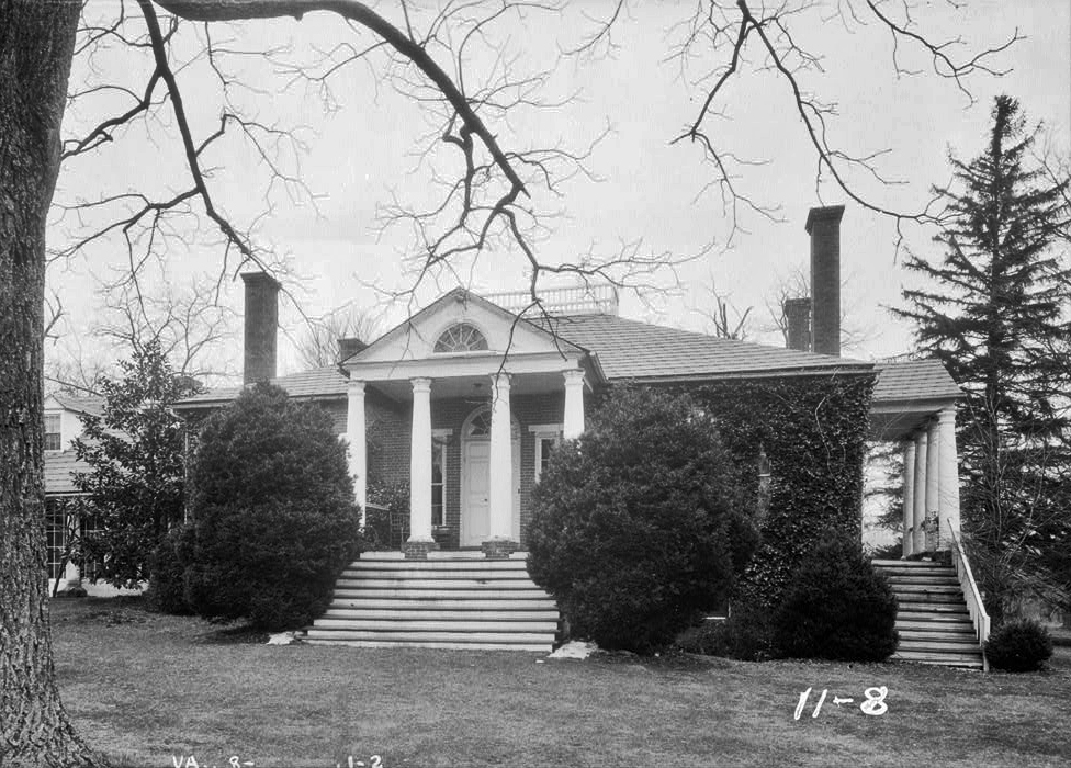
Folly
Monument and historic site · National Register of Historic Places · 6.1 mi
Historic plantation house located near Staunton, Virginia, United States

Harper House (Stuarts Draft, Virginia)
Monument and historic site · National Register of Historic Places · 1.7 mi
Historic house in Virginia, United States

Mt. Torry Furnace
Monument and historic site · National Register of Historic Places · 6.4 mi
Place in Virginia listed on National Register of Historic Places


Valley Railroad Stone Bridge
Bridge · National Register of Historic Places · 5.4 mi
Railway bridge in Virginia, United States of America
Parks, trails and playgrounds1

Restaurants and cafes12



Sanzone's Italian Restaurant
Restaurant · 1.4 mi
2897 Stuarts Draft Highway, Stuarts Draft

Domino's
Fast food · Pizza · 1.4 mi
2927 Stuarts Draft Highway, Stuarts Draft
Mo-Th 10:00-24:00; Fr-Sa 10:00-01:00; Su 10:00-24:00
Papa John's
Fast food · Pizza · 2.2 mi
3278 Stuarts Draft Highway, Waynesboro
Mo-Th 10:30-22:00; Fr-Sa 10:30-22:30; Su 11:00-22:00
Subway
Fast food · Sandwich · 1.3 mi
2857 Stuarts Draft Highway, Stuarts Draft
Mo-Fr 07:00-22:00; Sa 09:00-22:00; Su 08:00-22:00
DQ Grill & Chill
Fast food · Ice Cream, Burger, Chicken · 1.0 mi
2647 Stuarts Draft Highway, Stuarts Draft
History
Before the arrival of European settlers, the area was the territory of the Shawnee; none of their settlements are known to have existed in Stuarts Draft. Two non-resident tribes were frequent visitors to the area: the Delaware from the north and the Catawba from the south. When European settlers first moved into Augusta County in 1732, these three tribes were in the midst of a war. As a result, armed war parties were a common sight in the white settlements.
In 1736, William Beverly received a patent from Virginia's Governor William Gooch for 118,491 acres (479.52 km2; 47,952 ha) in what became Augusta County. At the time, this was the "outermost limits of Virginia". Beverly sold parcels of land to settlers, including property that is now in Stuarts Draft. One settler was Archibald Stuart, a Scotch Presbyterian, who arrived in the area in 1738. Stuart settled about three miles east of Tinkling Spring Presbyterian Church which he helped found in 1744. This property became known as the Pratt Farm and is located on what is now U.S. 340 near Northgate Avenue. Other early settlers who purchased land from Beverly in what is now Stuarts Draft include Robert Alexander, James Bell, John Black, John Christian, John Colter, Samuel Davidson, William Long, Finley McClure, Joseph Mills, Robert Moffet, and James Patton.
From the History section of Stuarts Draft, Virginia on Wikipedia, under CC BY-SA 4.0.
Where to stay9
Churches and places of worship17
Tinkling Spring Presbyterian Church
Church · National Register of Historic Places · 5.4 mi
Bible Truth Church
Church · Church Of God In Christ · 1.1 mi
16 Draft Avenue, Stuarts Draft
Finley Memorial Presbyterian Church
Church · Presbyterian · 0.7 mi
24 Finley Drive, Stuarts Draft
Shopping2
Gas and EV charging3
Schools, colleges and libraries11
Stuarts Draft Library Station
Library · 1.3 mi
2857 Stuarts Draft Highway, Stuarts Draft
Healthcare1
Map of Stuarts Draft
66 places. The map loads OpenStreetMap tiles when you open it.
Climate by month
Monthly table
| Month | High | Low | Rain |
|---|---|---|---|
| Jan | 44°F | 23°F | 3.2 in |
| Feb | 48°F | 25°F | 2.8 in |
| Mar | 55°F | 31°F | 4.1 in |
| Apr | 66°F | 40°F | 3.9 in |
| May | 74°F | 50°F | 3.6 in |
| Jun | 82°F | 59°F | 4.5 in |
| Jul | 86°F | 63°F | 3.7 in |
| Aug | 85°F | 61°F | 3.7 in |
| Sep | 78°F | 54°F | 5.5 in |
| Oct | 68°F | 43°F | 3.4 in |
| Nov | 56°F | 33°F | 4.0 in |
| Dec | 47°F | 27°F | 3.0 in |
U.S. Climate Normals 1991-2020 for Waynesboro Wtp (10 mi away), NOAA NCEI.
People and cost of living
American Community Survey 5-year estimates, 2020-2024, U.S. Census Bureau. Estimates have margins of error, larger for small towns.
Disaster history
Augusta County has had 11 federal disaster declarations since 2000, most often for hurricanes.
- 2026-01-23: Severe Winter Storm (Winter Storm)
- 2020-04-02: Covid-19 Pandemic (Biological)
- 2020-03-13: Covid-19 (Biological)
- 2018-09-11: Hurricane Florence (Hurricane)
- 2012-10-29: Hurricane Sandy (Hurricane)
- 2012-07-27: Severe Storms And Straight-Line Winds (Severe Storm)
OpenFEMA disaster declarations summaries.
Getting there and nearby towns
Shenandoah Valley Regional Airport (SHD) is the nearest airport with scheduled flights listed in OpenStreetMap, 19 miles away.
- Lyndhurst 4 mi east, about 7 min by car
- Fishersville 6 mi northeast, about 10 min by car
- Greenville 7 mi west, about 11 min by car
- Staunton 10 mi north, about 16 min by car
- Charlottesville 30 mi east, about 48 min by car
- Harrisonburg 30 mi north, about 49 min by car
- Lake Monticello 39 mi east, about 1 h by car
- Madison Heights 39 mi south, about 1 h by car
- Lynchburg 44 mi south, about 1 h 15 min by car
- Forest 46 mi south, about 1 h 15 min by car
Drive times are estimates from straight-line distance, not routes.
Local news
Headlines from INDB, the NEMICO news database.
Reviews, tips and questions
Loading what members have shared...
Sources and licences
- NCES EDGE (Public domain): public schools
- NOAA NCEI U.S. Climate Normals 1991-2020 (Public domain): climate by month
- OpenFEMA (Public domain): disaster declarations
- OpenStreetMap contributors (ODbL 1.0): places, airports, map data
- U.S. Census Bureau (Public domain): population, income, housing, education, commute
- Wikidata (CC0 1.0): elevation, founding date, time zone, website, landmarks and historic places
- Wikimedia Commons (see each image): photos
- Wikipedia (CC BY-SA 4.0): overview and history text
Photo credits
- US 340 US Route 340 - Virginia (8600381454), Doug Kerr from Albany, NY, United States, CC BY-SA 2.0
- 2016-05-27 19 16 43 View north along U.S. Route 340 (Stuarts Draft Highway) just north of the junction with Virginia State Secondary Route 608 (Draft Avenue) in Stuarts Draft, Augusta County, Virginia, Famartin, CC BY-SA 4.0
- 2016-05-27 19 29 05 View south along U.S. Route 340 (Stuarts Draft Highway) just north of the junction with Virginia State Secondary Route 649 (Locust Grove Lane) in Stuarts Draft, Augusta County..., Famartin, CC BY-SA 4.0
- Boys' restroom at Stuarts Draft Middle School (50867066512), Ben Schumin from Montgomery Village, Maryland, USA, CC BY-SA 2.0
- Eighth grade hall at Stuarts Draft Middle School (50867065852), Ben Schumin from Montgomery Village, Maryland, USA, CC BY-SA 2.0
- HARPER HSE, STUARTS DRAFT, AUGUSTA COUNTY, VA, JERRYE & ROY KLOTZ, M.D., CC BY-SA 4.0
- Chapel Hill near Mint Spring, Nyttend, Public domain
- Valley Railroad, Folly Mills Creek Viaduct, Interstate 81, Staunton vicinity (Augusta County, Virginia), Jack Boucher, Public domain
- Mount Torry Furnace 4x6 300ppi, Philip N. Wheeler, CC BY-SA 3.0
- Folly Farm HABS VA1, unknown HABS photographer, Public domain
- Tinkling Spring Presbyterian Church-4x6-300ppi, Philip N. Wheeler, CC BY-SA 3.0
- Washington Redskins golf cart (50866249833), Ben Schumin from Montgomery Village, Maryland, USA, CC BY-SA 2.0
- Finley Memorial Presbyterian Church, Ben Schumin, CC BY-SA 2.0
- John Colter historical marker, Gadget850, Public domain
- Shenandoah Acres tower, Ben Schumin, CC BY-SA 3.0
- Shenandoah Acres -02- (9726120886), Ben Schumin from Montgomery Village, Maryland, USA, CC BY-SA 2.0
- Shenandoah Acres -05- (9726124530), Ben Schumin from Montgomery Village, Maryland, USA, CC BY-SA 2.0
- Shenandoah Acres -06- (9722898135), Ben Schumin from Montgomery Village, Maryland, USA, CC BY-SA 2.0
- Shenandoah Acres -01- (9722890617), Ben Schumin from Montgomery Village, Maryland, USA, CC BY-SA 2.0
- Shenandoah Acres -04- (9726123046), Ben Schumin from Montgomery Village, Maryland, USA, CC BY-SA 2.0
- Shenandoah Acres -03- (9722903157), Ben Schumin from Montgomery Village, Maryland, USA, CC BY-SA 2.0
- US 340 2013-03-10 17 48 US Route 340 - Virginia (8600383238), Doug Kerr from Albany, NY, United States, CC BY-SA 2.0
- US 340 2013-03-10 17 49 US Route 340 - Virginia (8599284421), Doug Kerr from Albany, NY, United States, CC BY-SA 2.0
- Veterans of Foreign Wars Post 9339 - panoramio, Idawriter, CC BY-SA 3.0
- ISS067-E-127029 - View of Earth, Earth Science and Remote Sensing Unit , Lyndon B. Johnson Space Center, Public domain
- ISS043-E-243617 - View of Earth, Earth Science and Remote Sensing Unit , Lyndon B. Johnson Space Center, Public domain
- ISS043-E-243618 - View of Earth, Earth Science and Remote Sensing Unit , Lyndon B. Johnson Space Center, Public domain
- ISS043-E-243619 - View of Earth, Earth Science and Remote Sensing Unit , Lyndon B. Johnson Space Center, Public domain
- ISS065-E-111148 - View of Earth, Earth Science and Remote Sensing Unit , Lyndon B. Johnson Space Center, Public domain
- ISS037-E-7551 - View of Earth, Earth Science and Remote Sensing Unit , Lyndon B. Johnson Space Center, Public domain
- ISS043-E-243620 - View of Earth, Earth Science and Remote Sensing Unit , Lyndon B. Johnson Space Center, Public domain
- South River, VA, USA - panoramio, Idawriter, CC BY-SA 3.0
- Bare's Mill plaque, 4x6, 300ppi, Philip N. Wheeler, CC BY-SA 3.0
- Bare's Mill, 4x6, 300ppi, Philip N. Wheeler, CC BY-SA 3.0
- Eutrichillus biguttatus 8384487, Matt Muir, CC BY 4.0
- Oedemasia semirufescens - inat 8384542, Matt Muir Depicted place: Maple Flats ( 37°58′37″N 78°59′46″W / 37.9769553662°N 78.9961537201°W / 37.9769553662; -78.9961537201 ), CC BY-SA 4.0


Page built October 30, 2026. Spotted a mistake? Tell us or suggest a place.