


Why visit Summit
Townapedia lists 10 museums and landmarks, 28 parks and trails, 60 places to eat and 4 places to stay in and around town.
Highlights include St. John's Northwestern Military Academy, Bishopstead, Champion Field Park and Cushing Memorial Park.
July is the warmest month, with average highs of 82°F; January lows average 11°F, and about 40 inches of snow fall in a normal year.
Weather in Summit
Forecast from the National Weather Service. Full forecast
About Summit
Summit is a village in Waukesha County, Wisconsin, United States. The population was 4,784 at the 2020 census. The former unincorporated communities of Summit Center, Summit Corners, and Waterville are located in the village.
From the Wikipedia article Summit, Waukesha County, Wisconsin (this version), under CC BY-SA 4.0.
Museums and landmarks10

St. John's Northwestern Military Academy
Monument and historic site · National Register of Historic Places · 3.3 mi
Military boarding and day school in the United States
1101 North Genesee Street, Delafield

Bishopstead
Monument and historic site · National Register of Historic Places · 3.1 mi
Residence of Episcopalian bishop Jackson Kemper

Clarence Peck Residence
Monument and historic site · National Register of Historic Places · 4.4 mi
Historic house in Wisconsin, United States

Delafield Fish Hatchery
Monument and historic site · National Register of Historic Places · 3.4 mi
Hatchery in Delafield, Wisconsin, United States

Oconomowoc Milwaukee Road depot
Monument and historic site · National Register of Historic Places · 4.0 mi
Former Milwaukee Road depot in Wisconsin
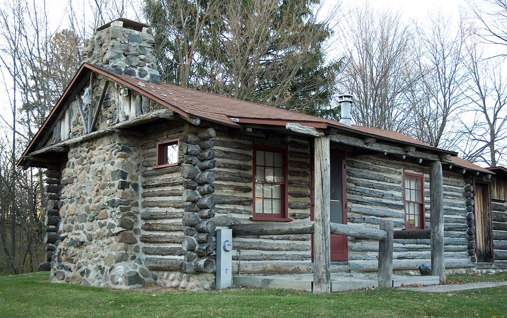
W. Ben Hunt Cabin
Monument and historic site · National Register of Historic Places · 5.5 mi
Historic house in Wisconsin, United States


Parks, trails and playgrounds28





16 more on the map.
Restaurants and cafes60

Giussepe's Pizzeria
Restaurant · Pizza · 3.6 mi
615 Main Street, Delafield
Mo,We,Th 16:00-20:00; Fr 15:00-21:00; Sa 12:00-21:00; Su...
Belfe Kitchen
Restaurant · 3.6 mi
606 Genesee Street, Delafield
Tu-Fr 11:00-21:00; Sa 09:00-21:00; Su 09:00-14:00


Here's The Scoop
Ice cream · 3.5 mi
807 Genesee Street, Delafield
We-Fr 14:00-20:00; Sa-Su 12:00-20:00
i.d.
Restaurant · 3.4 mi
415 Genesee Street
Mo-Th 17:00-21:00; Fr, Sa 17:00-22:00; Su 09:30-14:00, 17:00-21:00


48 more on the map.
Where to stay4


History
Summit was initially a part of Milwaukee County. The town was first settled in the spring of 1837 by Andrew Baxter. In 1838, Curtis Reed, who was the first town chairman, became the first postmaster. By 1840, there were 335 settlers in Summit's 36 square miles (93 km2). The first town meeting, which took place on April 5, 1842, selected Ralph Frisbie as the first town clerk.
The first church building in the Town of Summit was constructed in 1842 at Nashotah Mission. When the mission was moved to Delafield, St. Mary's Church on highways 67 and 18 became the oldest operating church in the town, dating back to 1871. The 1875 census reported 619 males, 540 females, 2 insane, 0 deaf and dumb, 0 blind and 0 colored. The last Native Americans in the area were seen in 1883. The first Town Hall was built in 1906 and torn down in 1954, after which another was built. On July 29, 2010, the town of Summit became a village. In April 2018 the Village Hall moved into a new building located at 37100 Delafield Road, just south of the previous location.
From the History section of Summit, Waukesha County, Wisconsin on Wikipedia, under CC BY-SA 4.0.
Churches and places of worship7
Chapel of St. Mary the Virgin
Church · National Register of Historic Places · 3.1 mi
St. John Chrysostom Church
Church · National Register of Historic Places · 3.5 mi
Saint Jerome Catholic Church
Church · Catholic · 3.1 mi
995 South Silver Lake Street, Oconomowoc
Shopping14
Gas and EV charging6
Schools, colleges and libraries30
Nashotah House Theological Seminary
School · 3.0 mi
2777 Mission Road, Nashotah
Healthcare6
Map of Summit
165 places. The map loads OpenStreetMap tiles when you open it.
Climate by month
Monthly table
| Month | High | Low | Rain | Snow |
|---|---|---|---|---|
| Jan | 28°F | 11°F | 1.6 in | 11.1 in |
| Feb | 32°F | 14°F | 1.6 in | 9.8 in |
| Mar | 44°F | 25°F | 2.1 in | 4.8 in |
| Apr | 56°F | 36°F | 3.9 in | 2.0 in |
| May | 69°F | 47°F | 4.1 in | 0.2 in |
| Jun | 78°F | 57°F | 4.9 in | 0.0 in |
| Jul | 82°F | 61°F | 4.1 in | 0.0 in |
| Aug | 81°F | 60°F | 4.2 in | 0.0 in |
| Sep | 74°F | 52°F | 3.4 in | 0.0 in |
| Oct | 61°F | 40°F | 2.8 in | 0.1 in |
| Nov | 46°F | 29°F | 2.2 in | 1.4 in |
| Dec | 34°F | 18°F | 1.9 in | 10.2 in |
U.S. Climate Normals 1991-2020 for Oconomowoc Wwtp (3 mi away), NOAA NCEI.
People and cost of living
American Community Survey 5-year estimates, 2020-2024, U.S. Census Bureau. Estimates have margins of error, larger for small towns.
Disaster history
Waukesha County has had 10 federal disaster declarations since 2000, most often for severe storms.
- 2026-06-30: Severe Storms, Tornadoes, And Flooding (Flood)
- 2025-09-11: Severe Storms, Straight-Line Winds, Flooding, And Mudslides (Flood)
- 2020-04-04: Covid-19 Pandemic (Biological)
- 2020-03-13: Covid-19 (Biological)
- 2008-06-14: Severe Storms, Tornadoes, And Flooding (Severe Storm)
- 2008-03-19: Record Snow And Near Record Snow (Snowstorm)
OpenFEMA disaster declarations summaries.
Getting there and nearby towns
Waukesha County Airport (UES) is the nearest airport with scheduled flights listed in OpenStreetMap, 12 miles away.
- Oconomowoc 3 mi north, about 5 min by car
- Dousman 3 mi south, about 5 min by car
- Delafield 4 mi east, about 7 min by car
- Nashotah 4 mi northeast, about 7 min by car
- Hartland 8 mi northeast, about 12 min by car
- Ixonia 8 mi northwest, about 13 min by car
- North Prairie 9 mi southeast, about 14 min by car
- Merton 10 mi northeast, about 16 min by car
- Waukesha 12 mi east, about 19 min by car
- Pewaukee 12 mi east, about 19 min by car
Drive times are estimates from straight-line distance, not routes.
Local news
Headlines from INDB, the NEMICO news database.
Reviews, tips and questions
Loading what members have shared...
Sources and licences
- NCES EDGE (Public domain): public schools
- NOAA NCEI U.S. Climate Normals 1991-2020 (Public domain): climate by month
- OpenFEMA (Public domain): disaster declarations
- OpenStreetMap contributors (ODbL 1.0): places, airports, map data
- U.S. Census Bureau (Public domain): population, income, housing, education, commute
- Wikidata (CC0 1.0): elevation, founding date, time zone, website, landmarks and historic places
- Wikimedia Commons (see each image): photos
- Wikipedia (CC BY-SA 4.0): overview and history text
Photo credits
- Summit (1), Awkwafaba, CC BY-SA 3.0
- Summit Cemetery, Awkwafaba, CC BY-SA 3.0
- Aurora Summit Medical Center heliport, Awkwafaba, CC BY-SA 3.0
- St Johns Military Academy, Shadowe, CC BY-SA 3.0
- Clarence Peck House, MeropeRiddle, CC BY-SA 3.0
- StMaryVirgin, Jonathunder, GFDL 1.2
- Bishopstead, Shadowe, CC BY-SA 3.0
- Oconomowoc Depot, Shadowe, CC BY-SA 3.0
- St. John Chrysotom Church, James Steakley, CC BY-SA 3.0
- Delafield Fish Hatchery, Shadowe, CC BY-SA 3.0
- Ben Hunt Cabin Nov2011, Freekee, CC0
- Westbrook Church, Awkwafaba, CC BY-SA 3.0
- Hidden Ridge Park, Awkwafaba, CC BY-SA 3.0
- The Gustave Pabst House on the Estate, Boscophotos, CC BY-SA 3.0
- Middle Genesee Lake, Awkwafaba, CC BY-SA 3.0
- Wisconsin Brewing Company Park, BrewCityStu, CC BY-SA 4.0
- Bishop Juan Alberto Morales, 9th Bishop of Quincy, Fr. Robert Goebel, CC BY-SA 4.0
- State Highway 67 Overpass - panoramio, Corey Coyle, CC BY 3.0
- White Stone Community Church Oconomowoc, WI - panoramio, Corey Coyle, CC BY 3.0
- Candy Raisins 02, Awkwafaba, CC BY-SA 4.0
- Oconomowoc's Mole Hill - panoramio, Corey Coyle, CC BY 3.0
- Pabst farms, Awkwafaba, CC BY-SA 3.0
- ATC Power Lines - panoramio (67), Corey Coyle, CC BY 3.0
- ATC Power Lines - panoramio (68), Corey Coyle, CC BY 3.0
- ATC Power Lines - panoramio (64), Corey Coyle, CC BY 3.0
- Lake Country Trail Underpass, Awkwafaba, CC BY-SA 3.0
- Laura Lake, Awkwafaba, CC BY-SA 3.0
- ATC Power Lines - panoramio (63), Corey Coyle, CC BY 3.0
- G. William “Bill” Chapman plaque 1, Awkwafaba, CC BY-SA 4.0
- G. William “Bill” Chapman plaque 2, Awkwafaba, CC BY-SA 4.0
- Aunt Polly’s Wash Tub 1, Awkwafaba, CC BY-SA 4.0
- Upper Nemahbin Lake - panoramio, Corey Coyle, CC BY 3.0
- ATC Power Lines - panoramio (65), Corey Coyle, CC BY 3.0
- Lower Nemahbin Lake - panoramio, Corey Coyle, CC BY 3.0
- Upper Nemahbin Lake, Awkwafaba, CC BY-SA 3.0
- Oconomowoc Tower 3 - panoramio, Corey Coyle, CC BY 3.0
- Aunt Polly’s Wash Tub from Joyce’s lookout, Awkwafaba, CC BY-SA 4.0
- Joyce’s Lookout in ChapmaN Park, Awkwafaba, CC BY-SA 4.0
- ATC Power Lines - panoramio (66), Corey Coyle, CC BY 3.0
- Communication Tower - panoramio - Corey Coyle, Corey Coyle, CC BY 3.0


Page built October 30, 2026. Spotted a mistake? Tell us or suggest a place.