
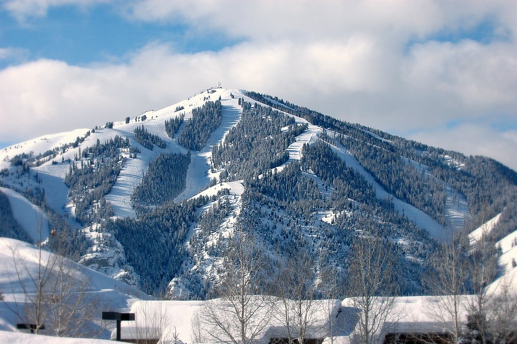


Sun Valley, Idaho
Sun Valley is a city of 1,460 people in Blaine County, Idaho, founded in December 21, 1936.
Why visit Sun Valley
Townapedia lists 7 museums and landmarks, 13 parks and trails, 15 places to eat, 7 places to stay and 11 attractions in and around town.
Highlights include Cold Springs Pegram Truss Railroad Bridge, Dollar Mountain, Proctor Mountain Ski Lift and Bald Mountain Hot Springs.
July is the warmest month, with average highs of 80°F; January lows average 8°F, and about 102 inches of snow fall in a normal year.
Weather in Sun Valley
Forecast from the National Weather Service. Full forecast
About Sun Valley
Sun Valley is a resort town and alpine ski resort in the western United States, in Blaine County, Idaho, adjacent to the city of Ketchum in the Wood River valley. The population was 1,783 at the 2020 census. The elevation of Sun Valley (at the Lodge) is 5,920 feet (1,805 m) above sea level.
From the Wikipedia article Sun Valley, Idaho (this version), under CC BY-SA 4.0.
Things to do11

Cold Springs Pegram Truss Railroad Bridge
Bridge · National Register of Historic Places · 2.2 mi
Bridge in United States of America



Museums and landmarks7

Proctor Mountain Ski Lift
Monument and historic site · National Register of Historic Places · 1.6 mi
Historic ski lift in Sun Valley, Idaho, United States
Bald Mountain Hot Springs
Monument and historic site · National Register of Historic Places · 1.4 mi
Greenhow and Rumsey Store Building
Monument and historic site · National Register of Historic Places · 1.5 mi
Ketchum Ranger District Administrative Site
Monument and historic site · National Register of Historic Places · 1.5 mi

Parks, trails and playgrounds13

Ketchum Bike Park
Park · 1.8 mi
Ketchum Bike Dirt Pump Track
700 2nd Avenue, Ketchum

Christina Potters Outdoor Ice Rink
Sports field and stadium · 1.9 mi
900 3rd Avenue, Ketchum


1 more on the map.
Restaurants and cafes15


Enoteca
Restaurant · Pizza · 1.5 mi
300 North Main Street, Ketchum
Su-Th 05:00-21:00; Fr,Sa 05:00-21:15

Pioneer Saloon
Restaurant · 1.5 mi
320 North Main Street, Ketchum
Mo-Su 16:00-21:30

3 more on the map.
Where to stay7
Churches and places of worship3
Our Lady of the Snows Catholic Church
Church · Roman Catholic · 1.3 mi
202 East Sun Valley Road, Sun Valley
The Church of Jesus Christ of Latter-day Saints
Church · Mormon · 1.3 mi
300 Spruce Avenue, Ketchum
Shopping8
Schools, colleges and libraries3
Healthcare1
Map of Sun Valley
68 places. The map loads OpenStreetMap tiles when you open it.
Climate by month
Monthly table
| Month | High | Low | Rain | Snow |
|---|---|---|---|---|
| Jan | 31°F | 8°F | 2.2 in | 27.0 in |
| Feb | 35°F | 11°F | 1.9 in | 17.2 in |
| Mar | 43°F | 19°F | 1.8 in | 10.5 in |
| Apr | 52°F | 27°F | 1.2 in | 3.2 in |
| May | 62°F | 35°F | 1.8 in | 0.2 in |
| Jun | 70°F | 40°F | 1.3 in | 0.0 in |
| Jul | 80°F | 45°F | 0.6 in | 0.0 in |
| Aug | 79°F | 44°F | 0.5 in | 0.0 in |
| Sep | 69°F | 36°F | 1.0 in | 0.0 in |
| Oct | 56°F | 28°F | 1.4 in | 1.6 in |
| Nov | 41°F | 17°F | 1.2 in | 10.3 in |
| Dec | 30°F | 9°F | 2.6 in | 32.0 in |
U.S. Climate Normals 1991-2020 for Ketchum Rs Hcn (1 mi away), NOAA NCEI.
People and cost of living
American Community Survey 5-year estimates, 2020-2024, U.S. Census Bureau. Estimates have margins of error, larger for small towns.
Disaster history
Blaine County has had 8 federal disaster declarations since 2000, most often for fires.
- 2022-09-05: Ross Fork Fire (Fire)
- 2020-04-09: Covid-19 Pandemic (Biological)
- 2020-03-13: Covid-19 (Biological)
- 2017-08-27: Flooding, Landslides, And Mudslides (Flood)
- 2013-08-15: Beaver Creek Fire (Fire)
- 2007-08-28: Castle Rock Fire (Fire)
OpenFEMA disaster declarations summaries.
Getting there and nearby towns
Sun Valley / Friedman Memorial Airport (SUN) is the nearest airport with scheduled flights listed in OpenStreetMap, 12 miles away.
- Ketchum 2 mi west, about 3 min by car
- Hailey 12 mi south, about 19 min by car
- Bellevue 15 mi south, about 25 min by car
- Carey 32 mi southeast, about 52 min by car
- Fairfield 33 mi southwest, about 53 min by car
- Mackay 39 mi northeast, about 1 h by car
- Richfield 45 mi south, about 1 h 15 min by car
- Stanley 47 mi northwest, about 1 h 15 min by car
- Shoshone 52 mi south, about 1 h 30 min by car
- Gooding 55 mi south, about 1 h 30 min by car
Drive times are estimates from straight-line distance, not routes.
Local news
Headlines from INDB, the NEMICO news database.
Reviews, tips and questions
Loading what members have shared...
Sources and licences
- NCES EDGE (Public domain): public schools
- NOAA NCEI U.S. Climate Normals 1991-2020 (Public domain): climate by month
- OpenFEMA (Public domain): disaster declarations
- OpenStreetMap contributors (ODbL 1.0): places, airports, map data
- U.S. Census Bureau (Public domain): population, income, housing, education, commute
- Wikidata (CC0 1.0): elevation, founding date, time zone, website, landmarks and historic places
- Wikimedia Commons (see each image): photos
- Wikipedia (CC BY-SA 4.0): overview and history text
Photo credits
- Baldmountainid, Greg L. Wright - SnapJag, CC BY-SA 3.0
- Greetings from Sun Valley, Idaho - Large Letter Postcard (4237368938), Steve Shook from Moscow, Idaho, USA, CC BY 2.0
- Sun Valley, Idaho 2024 - Old Pickup, Sharon Hahn Darlin, CC BY 2.0
- Sun Valley, Idaho Classic Chevy, Sharon Hahn Darlin, CC BY 2.0
- Ranchland On The Way To Sun Valley, Gord Schindell, CC BY 3.0
- The chairlift at Ruud - Proctor Mountain in Sun Valley, Idaho USA (one of the first chairlifts ever), Kingmiwok, CC BY-SA 4.0
- Bowling balls (8595594527), Tom Hentoff, CC BY 2.0
- Maria Konnikova in 2013, Thomas Hawk, CC BY 2.0
- Ketchum, Idaho street scene July 2024, Sharon Hahn Darlin, CC BY 2.0
- Starbucks - panoramio (4), Oleg Moskalensky, CC BY 3.0
- Ketchum, Idaho street July 2024, Sharon Hahn Darlin, CC BY 2.0
- Greenhow And Rumsey Store Building NRHP 83000280 Blaine County, ID, Jon Roanhaus, CC BY-SA 4.0
- Greenhow And Rumsey Store Building2 NRHP 83000280 Blaine County, ID, Jon Roanhaus, CC BY-SA 4.0
- Ketchum, Idaho-6873, Frank Schulenburg, CC BY-SA 4.0
- Ketchum, Idaho-6870, Frank Schulenburg, CC BY-SA 4.0
- Ketchum, Idaho-6864, Frank Schulenburg, CC BY-SA 4.0
- Ketchum, Idaho-6891, Frank Schulenburg, CC BY-SA 4.0
- Ketchum, Idaho-6888, Frank Schulenburg, CC BY-SA 4.0
- Bald Mountain, Idaho, Sam Beebe, CC BY-SA 2.0
- Ketchum, Idaho-6916, Frank Schulenburg, CC BY-SA 4.0
- ISS066-E-143656 - View of Earth, Earth Science and Remote Sensing Unit , Lyndon B. Johnson Space Center, Public domain
- ISS040-E-108910 - View of Earth, Earth Science and Remote Sensing Unit , Lyndon B. Johnson Space Center, Public domain
- ISS027-E-29640 - View of Earth, Earth Science and Remote Sensing Unit , Lyndon B. Johnson Space Center, Public domain
- ISS029-E-30627 - View of Earth, Earth Science and Remote Sensing Unit , Lyndon B. Johnson Space Center, Public domain
- ISS066-E-143658 - View of Earth, Earth Science and Remote Sensing Unit , Lyndon B. Johnson Space Center, Public domain
- ISS040-E-108911 - View of Earth, Earth Science and Remote Sensing Unit , Lyndon B. Johnson Space Center, Public domain
- ISS066-E-143657 - View of Earth, Earth Science and Remote Sensing Unit , Lyndon B. Johnson Space Center, Public domain
- ISS040-E-108912 - View of Earth, Earth Science and Remote Sensing Unit , Lyndon B. Johnson Space Center, Public domain
- Cold-Springs-Bridge, Andrew Dumke, CC BY-SA 3.0
- Fox (6218556271), Ben Christenson, CC BY 2.0
- University of Washington Ski Team, ca. 1930 (500109374), UW Digital Collections, No restrictions


Page built October 30, 2026. Spotted a mistake? Tell us or suggest a place.