
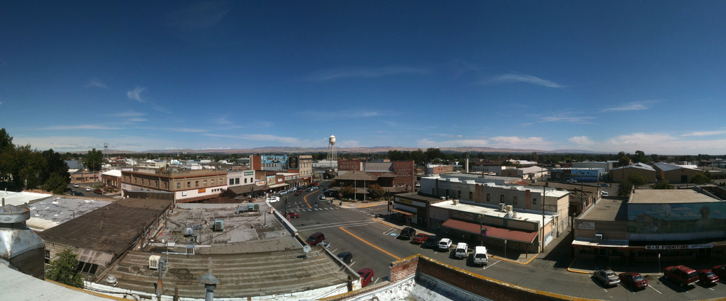


Why visit Toppenish
Townapedia lists 4 museums and landmarks, 10 parks and trails, 15 places to eat, 2 places to stay and 1 attraction in and around town.
Highlights include Heritage Theater, Teapot Dome Service Station and Yakima Indian Agency Building.
July is the warmest month, with average highs of 90°F; December lows average 23°F, and about 20 inches of snow fall in a normal year.
Weather in Toppenish
Forecast from the National Weather Service. Full forecast
About Toppenish
Toppenish () is a city in Yakima County, Washington, United States. The population was 8,854 at the 2020 census. It is located within the Yakama Indian Reservation, established in 1855. The city was founded in 1884 on a section of the Northern Pacific Railway through the Yakima Valley.
From the Wikipedia article Toppenish, Washington (this version), under CC BY-SA 4.0.
Things to do1

Museums and landmarks4

Teapot Dome Service Station
Monument and historic site · National Register of Historic Places · 2.7 mi
Service station shaped like a teapot


Yakima Indian Agency Building
Monument and historic site · National Register of Historic Places

American Hop Museum
Museum · 0.4 mi
May 01-Sep 30 We-Sa 10:00-16:00; May 01-Sep 30 Su 11:00-16:00; Oct...
Parks, trails and playgrounds10


Restaurants and cafes15

El Charrito
Restaurant · Mexican
120 East Toppenish Avenue, Toppenish
Mo-Su 10:00-22:00


Taco’n Madre
Fast food · Mexican · 1.0 mi
111 Fort Road, Toppenish
Mo-Su 09:00-19:00
3 more on the map.
History
All territory set aside for the Yakama Indian Reservation by the Treaty of Washington was held communally in the name of the tribe. None of the land was individually owned. The treaty of 1855, between the United States government, representatives from thirteen other bands, tribes, and Chief Kamiakin, resulted in the Yakama Nation relinquishing 16,920 square miles (43,800 km2) of their homeland. Prior to their ceding the land, only Native Americans had lived in the area.
For a time they were not much disturbed, but the Northern Pacific Railway was constructed into the area in 1883. More white settlers migrated into the region, looking for farming land, and joined the ranchers in older settlements bordering the Columbia River.
From the History section of Toppenish, Washington on Wikipedia, under CC BY-SA 4.0.
Where to stay2
Churches and places of worship5
Shopping2
Gas and EV charging8
Schools, colleges and libraries18
Healthcare4
Map of Toppenish
69 places. The map loads OpenStreetMap tiles when you open it.
Climate by month
Monthly table
| Month | High | Low | Rain | Snow |
|---|---|---|---|---|
| Jan | 39°F | 24°F | 1.1 in | 5.2 in |
| Feb | 48°F | 26°F | 0.6 in | 1.1 in |
| Mar | 57°F | 33°F | 0.6 in | 0.3 in |
| Apr | 65°F | 39°F | 0.6 in | 0.0 in |
| May | 74°F | 47°F | 0.8 in | 0.0 in |
| Jun | 81°F | 53°F | 0.5 in | 0.0 in |
| Jul | 90°F | 59°F | 0.2 in | 0.0 in |
| Aug | 89°F | 58°F | 0.2 in | 0.0 in |
| Sep | 80°F | 49°F | 0.2 in | 0.0 in |
| Oct | 66°F | 37°F | 0.6 in | 0.2 in |
| Nov | 50°F | 29°F | 0.9 in | 1.6 in |
| Dec | 38°F | 23°F | 1.4 in | 12.0 in |
U.S. Climate Normals 1991-2020 for Wapato (6 mi away), NOAA NCEI.
People and cost of living
American Community Survey 5-year estimates, 2020-2024, U.S. Census Bureau. Estimates have margins of error, larger for small towns.
Disaster history
Yakima County has had 28 federal disaster declarations since 2000, most often for fires.
- 2026-08-03: Wildfires (Fire)
- 2026-07-26: Signal Peak Fire (Fire)
- 2026-07-26: Ransier Fire (Fire)
- 2026-04-07: Severe Storms, Straight-Line Winds, Flooding, Landslides, And Mudslides (Flood)
- 2025-12-12: Severe Storms, Straight-Line Winds, Flooding, Landslides, And Mudslides (Flood)
- 2024-07-26: Retreat Fire (Fire)
OpenFEMA disaster declarations summaries.
Getting there and nearby towns
Yakima Air Terminal (YKM) is the nearest airport with scheduled flights listed in OpenStreetMap, 17 miles away.
- Zillah 3 mi northeast, about 4 min by car
- Granger 6 mi southeast, about 10 min by car
- Wapato 7 mi northwest, about 11 min by car
- Sunnyside 15 mi east, about 25 min by car
- Terrace Heights 16 mi north, about 26 min by car
- Yakima 18 mi northwest, about 30 min by car
- Ahtanum 19 mi northwest, about 30 min by car
- Mabton 19 mi southeast, about 31 min by car
- Grandview 21 mi southeast, about 34 min by car
- Selah 21 mi northwest, about 34 min by car
Drive times are estimates from straight-line distance, not routes.
Local news
Headlines from INDB, the NEMICO news database.
Reviews, tips and questions
Loading what members have shared...
Sources and licences
- NCES EDGE (Public domain): public schools
- NOAA NCEI U.S. Climate Normals 1991-2020 (Public domain): climate by month
- OpenFEMA (Public domain): disaster declarations
- OpenStreetMap contributors (ODbL 1.0): places, airports, map data
- U.S. Census Bureau (Public domain): population, income, housing, education, commute
- Wikidata (CC0 1.0): elevation, founding date, time zone, website, landmarks and historic places
- Wikimedia Commons (see each image): photos
- Wikipedia (CC BY-SA 4.0): overview and history text
Photo credits
- ToppenishPanorama, Jared DeJong, CC BY 2.0
- Teapot Dome Service Station, Zillah WA, Iflorea, CC BY-SA 4.0
- Yakima Indian Agency Building, Steven Pavlov, CC BY-SA 4.0
Page built October 30, 2026. Spotted a mistake? Tell us or suggest a place.