
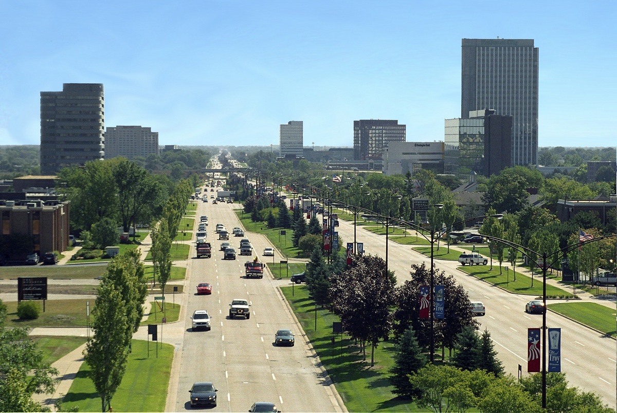


Why visit Troy
Townapedia lists 34 museums and landmarks, 64 parks and trails, 250 places to eat, 20 places to stay and 6 attractions in and around town.
Highlights include Derby Street-Grand Trunk Western Railroad Bridge, Trowbridge Road-Grand Trunk Western Railroad Bridge, Troy Historic Village and Brooks Farm.
July is the warmest month, with average highs of 82°F; January lows average 17°F, and about 36 inches of snow fall in a normal year.
Weather in Troy
Forecast from the National Weather Service. Full forecast
About Troy
Troy is a city in Oakland County in the U.S. state of Michigan. A northern suburb of Detroit, Troy is located about 15 miles (24 km) north of downtown Detroit. As of the 2020 census, the city had a population of 87,294; this makes Troy the largest community in Oakland County and 13th-most populous municipality in the state.
From the Wikipedia article Troy, Michigan (this version), under CC BY-SA 4.0.
Things to do6

Derby Street-Grand Trunk Western Railroad Bridge
Bridge · National Register of Historic Places · 3.6 mi
Road bridge in Birmingham, United States of America

Trowbridge Road-Grand Trunk Western Railroad Bridge
Bridge · National Register of Historic Places · 4.3 mi
Road bridge in Bloomfield Hills, United States of America


International Academy of Design & Technology – Detroit
School · 2.6 mi
Education organization in Troy, United States
Rochester Christian University
School · 5.8 mi
Private Christian university in Rochester Hills, Michigan
Museums and landmarks34


Brooks Farm
Monument and historic site · National Register of Historic Places · 2.8 mi
Also known as the William Brooks Farm, historic farmsite in Troy, Michigan, U.S

Caswell House (Troy, Michigan)
Monument and historic site · National Register of Historic Places · 0.5 mi
Historic house in Michigan, United States

Charles Torrey House
Monument and historic site · National Register of Historic Places · 4.5 mi
Single-family detached home in Bloomfield Township, United States of America

Cranbrook Educational Community
Monument and historic site · National Register of Historic Places · 5.1 mi
Campus

Grand Trunk Western Railroad Birmingham Depot
Monument and historic site · National Register of Historic Places · 3.6 mi
Railway station in Birmingham, the United States of America

Gregor S. and Elizabeth B. Affleck House
Monument and historic site · National Register of Historic Places · 5.3 mi
United States historic place

H. Augustus and Agnes Cleveland O'Dell House
Monument and historic site · National Register of Historic Places · 5.1 mi
Single-family detached home in Bloomfield Hills, United States of America

Hilzinger Block
Monument and historic site · National Register of Historic Places · 6.5 mi
Commercial building located at 106-110 South Main Street in Royal Oak, Michigan

John & Mary Elizabeth Booth Endicott House
Monument and historic site · National Register of Historic Places · 4.6 mi
Single-family detached home in Bloomfield Hills, United States of America

John W. Hunter House
Monument and historic site · National Register of Historic Places · 4.6 mi
House in Birmingham, United States of America


Meadow Brook Hall
Monument and historic site · National Register of Historic Places · 6.7 mi
Rochester Hills, Michigan, the former Estate of Matilda Dodge Wilson
22 more on the map.
Parks, trails and playgrounds64

Brinston Park
Park · 3.0 mi
Brinston Park provides an excellent selection of recreational activities with two ball diamonds, two soccer fields, two tennis courts, a...
2262 Brinston Avenue, Troy
Halmich Park
Park · 5.5 mi
Park in Macomb County, Michigan, United States of America
Lloyd A. Stage Nature Center & Troy Farm
Park · 3.4 mi
6685 Coolidge Highway, Troy

52 more on the map.
Restaurants and cafes250

Al Shahbaa
Restaurant · Mediterranean · 3.7 mi
Located within County Line Plaza
2097 15 Mile Road, Sterling Heights
Mo-Su 11:00-14:00
Chung Ki Wa
Restaurant · Chinese, Korean, Barbecue · 3.8 mi
Located within County Line Plaza
2101 15 Mile Road, Sterling Heights
Mo-Sa 11:00-22:00; Su 12:00-22:00

Bowl & Wrap
Restaurant · 3.7 mi
Located within County Line Plaza
2095 15 Mile Road, Sterling Heights
Mo-Su 10:00-21:00
Due Venti
Restaurant · Italian · 3.6 mi
220 South Main Street, Clawson
Tu-Th 17:00-10:00; Fr-Sa 17:00-24:00
Ridley's Bakery Café
Restaurant · Sandwich · 1.0 mi
4054 Rochester Road, Troy
Mo-Fr 05:45-16:00; Sa 06:45-16:00

Tim Hortons
Cafe · Coffee Shop · 1.4 mi
3331 Rochester Road, Troy
Mo-We 04:00-21:00; Fr 04:00-21:00; Sa-Su 04:30-21:00
Tim Hortons
Cafe · Coffee Shop · 3.6 mi
1230 West 14 Mile Road, Clawson
Mo-We 05:00-20:00; Fr 05:00-20:00; Sa-Su 06:00-20:00
238 more on the map.
History
The earliest recorded purchases of land in what was known as Troy Township occurred in 1819. A couple of years later, a settlement known as Troy Corners was established due to Johnson Niles buying 160 acres in the region. The area is currently the north-central area of Troy. In 1827, Troy Township was established. In 1955, Troy was officially incorporated primarily as a strategy for preventing border cities from taking more land. This also helped to establish more robust city services for Troy residents, whose numbers increased rapidly during this time due to Detroiters fleeing the city for the surrounding suburbs.
It was named after Troy, New York and the ancient city of Troy as many of the early settlers, as in much of Michigan, originated from New York.
From the History section of Troy, Michigan on Wikipedia, under CC BY-SA 4.0.
Where to stay20
Days Inn & Suites by Wyndham Madison Heights MI
Motel and hotel · 3.7 mi
1331 West 14 Mile Road, Madison Heights
Fairfield Inn & Suites Rochester Hills
Motel and hotel · 2.9 mi
3900 South Rochester Road, Rochester Hills
Churches and places of worship57
Shopping60
Gas and EV charging39
Schools, colleges and libraries86
Healthcare23
Get Well Urgent Care Of Sterling Heights
Clinic and pharmacy · 3.5 mi
2567 Metropolitan Parkway, Sterling Heights
Prism Medical Group Family Medicine - Rochester
Clinic and pharmacy · 3.8 mi
1701, #160/240 East South Boulevard
MedPost Urgent Care of Rochester Hills
Clinic and pharmacy · 3.6 mi
3035 South Rochester Road, Rochester Hills
Map of Troy
250 places. The map loads OpenStreetMap tiles when you open it.
Climate by month
Monthly table
| Month | High | Low | Rain | Snow |
|---|---|---|---|---|
| Jan | 31°F | 17°F | 2.2 in | 12.1 in |
| Feb | 34°F | 18°F | 1.9 in | 9.0 in |
| Mar | 44°F | 26°F | 2.2 in | 4.1 in |
| Apr | 58°F | 36°F | 2.9 in | 0.9 in |
| May | 69°F | 49°F | 3.8 in | 0.0 in |
| Jun | 78°F | 59°F | 3.3 in | 0.0 in |
| Jul | 82°F | 63°F | 3.1 in | 0.0 in |
| Aug | 81°F | 62°F | 3.2 in | 0.0 in |
| Sep | 74°F | 54°F | 2.9 in | 0.0 in |
| Oct | 60°F | 42°F | 2.9 in | 0.1 in |
| Nov | 47°F | 32°F | 3.1 in | 1.7 in |
| Dec | 36°F | 24°F | 2.2 in | 8.1 in |
U.S. Climate Normals 1991-2020 for Pontiac Wwtp (7 mi away), NOAA NCEI.
People and cost of living
American Community Survey 5-year estimates, 2020-2024, U.S. Census Bureau. Estimates have margins of error, larger for small towns.
Disaster history
Oakland County has had 10 federal disaster declarations since 2000, most often for severe storms.
- 2024-02-08: Severe Storms, Tornadoes, And Flooding (Flood)
- 2021-07-15: Severe Storms, Flooding, And Tornadoes (Severe Storm)
- 2020-03-27: Covid-19 Pandemic (Biological)
- 2020-03-13: Covid-19 (Biological)
- 2014-09-25: Severe Storms And Flooding (Flood)
- 2005-09-07: Hurricane Katrina Evacuation (Hurricane)
OpenFEMA disaster declarations summaries.
Getting there and nearby towns
Coleman A. Young Municipal Airport (DET) is the nearest airport with scheduled flights listed in OpenStreetMap, 14 miles away.
- Clawson 3 mi south, about 5 min by car
- Birmingham 5 mi southwest, about 7 min by car
- Royal Oak 5 mi south, about 8 min by car
- Rochester Hills 6 mi north, about 9 min by car
- Sterling Heights 6 mi east, about 9 min by car
- Madison Heights 6 mi south, about 9 min by car
- Berkley 6 mi south, about 10 min by car
- Beverly Hills 6 mi southwest, about 10 min by car
- Rochester 7 mi north, about 12 min by car
- Warren 9 mi southeast, about 14 min by car
Drive times are estimates from straight-line distance, not routes.
Local news
Headlines from INDB, the NEMICO news database.
Reviews, tips and questions
Loading what members have shared...
Sources and licences
- NCES EDGE (Public domain): public schools
- NOAA NCEI U.S. Climate Normals 1991-2020 (Public domain): climate by month
- OpenFEMA (Public domain): disaster declarations
- OpenStreetMap contributors (ODbL 1.0): places, airports, map data
- U.S. Census Bureau (Public domain): population, income, housing, education, commute
- Wikidata (CC0 1.0): elevation, founding date, time zone, website, landmarks and historic places
- Wikimedia Commons (see each image): photos
- Wikipedia (CC BY-SA 4.0): overview and history text
Photo credits
- 16miletroy, Cadiomals, CC BY-SA 3.0
- Childrens Hospital of Michigan - Troy, Lrgjr72, CC BY-SA 4.0
- Top of Troy, Troy, Michigan (21728939181), Ken Lund from Reno, Nevada, USA, CC BY-SA 2.0
- PNC Building (Top of Troy) Night, Lrgjr72, CC BY-SA 4.0
- Top of Troy, Troy, Michigan (21728942001), Ken Lund from Reno, Nevada, USA, CC BY-SA 2.0
- J. Alexander’s at Somerset in Troy Michigan (0528), Gregory Varnum, CC BY-SA 4.0
- Somerset Collection in Troy (looking southeast), Lrgjr72, CC BY-SA 4.0
- Gregor S and Elizabeth B Affleck House Bloomfield Hills MI, Andrew Jameson, CC BY-SA 3.0
- Charles Torrey House Birmingham MI, Andrew Jameson, CC BY-SA 3.0
- DerbyStreet-GrandTrunkWesternRailroadBridgeBirminghamMiA, Andrew Jameson, CC BY-SA 3.0
- JohnWHunterHouseBirminghamMI, Andrew Jameson, CC BY-SA 3.0
- Rochester Michigan Rollin Sprague Building, Cjunker1 at en.wikipedia, Public domain
- Trowbridge Road-Grand Trunk Western Railroad Bridge Bloomfield Hills MI A, Andrew Jameson, CC BY-SA 3.0
- GrandTrunkWesternRailroadBirminghamMIDepot, Andrew Jameson, CC BY-SA 3.0
- Hilzinger Block Royal Oak MI, Andrew Jameson, CC BY-SA 3.0
- Caswell House Troy MI, Andrew Jameson, CC BY-SA 3.0
- Cranbrook, 1a, Shoughto at English Wikipedia, CC BY-SA 3.0
- Meadowbrook Hall, Wm. Chris Rowland, II, CC BY-SA 3.0
- Minoru and Teruko Yamasaki House Bloomfield Hills Michigan, Darren56brown, CC BY-SA 3.0
- BrooksFarmhouseTroyMi, Andrew Jameson, CC BY-SA 3.0
- ThomasWandMargaretTaliaferroHouse01, Traveler100, CC BY-SA 3.0
- JohnAndMaryElizabethBoothEndicottHouseBloomfieldHillsMi, Andrew Jameson, CC BY-SA 3.0
- Melvyn Maxwell Smith House exterior 2 - FLW, Architect - Bloomfield Hills built in 1946 (291334715), David Brossard, CC BY-SA 2.0
- Rochester Michigan Western Knitting Mills, Cjunker1 at en.wikipedia, Public domain
- 20231014Chung2, Cjchung4, CC BY-SA 4.0
- ChanJinChung, Cjchung4, CC BY-SA 4.0
- Cjchung2021, Cjchung4, CC BY-SA 4.0
- Oakland County 52-4 District Court (October 9, 2026) 09, Elli, CC0
- Oakland County 52-4 District Court (October 9, 2026) 03, Elli, CC0
- Oakland County 52-4 District Court (October 9, 2026) 02, Elli, CC0
- Oakland County 52-4 District Court (October 9, 2026) 01, Elli, CC0
- Oakland County 52-4 District Court (October 9, 2026) 08, Elli, CC0
- Oakland County 52-4 District Court (October 9, 2026) 06, Elli, CC0
- Oakland County 52-4 District Court (October 9, 2026) 07, Elli, CC0
- Oakland County 52-4 District Court (October 9, 2026) 04, Elli, CC0
- Oakland County 52-4 District Court (October 9, 2026) 05, Elli, CC0
- Paolo Bacigalupi (5378078948), Dave Hogg from Royal Oak, MI, USA, CC BY 2.0
- Brent Weeks (6737456579), Dave Hogg from Royal Oak, MI, USA, CC BY 2.0
- Joe Abercrombie (6740618491), Dave Hogg from Royal Oak, MI, USA, CC BY 2.0
- Vernor Vinge (89983686), Dave Hogg from Royal Oak, MI, USA, CC BY 2.0


Page built October 30, 2026. Spotted a mistake? Tell us or suggest a place.