


Trumansburg, New York
Trumansburg is a village of 1,665 people in Tompkins County, New York, founded in 1872.
Why visit Trumansburg
Townapedia lists 5 museums and landmarks, 8 places to eat and 1 attraction in and around town.
Highlights include Taughannock Falls, Covert Historic District and Hermon Camp House.
July is the warmest month, with average highs of 79°F; January lows average 14°F.
Weather in Trumansburg
Forecast from the National Weather Service. Full forecast
About Trumansburg
Trumansburg is a village in Tompkins County, New York, United States. The population was 1,714 at the 2020 census. The name incorporates a misspelling of the surname of the founder, Abner Treman. The Tremans spelled their surname several different ways; "Truman", however, was not one of them.
From the Wikipedia article Trumansburg, New York (this version), under CC BY-SA 4.0.
Things to do1

Taughannock Falls
Waterfall · 2.7 mi
Waterfall in Tompkins County, New York State, USA
Museums and landmarks5

Covert Historic District
Monument and historic site · National Register of Historic Places · 2.5 mi
Historic district in New York, United States
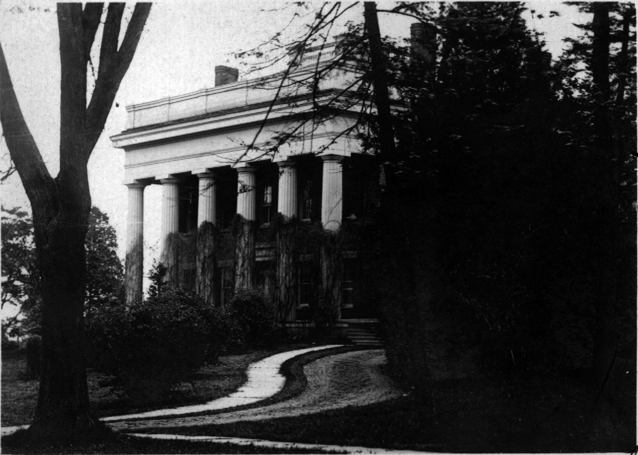
Hermon Camp House
Monument and historic site · National Register of Historic Places
Trumansburg, New York, NRHP-listed

Nicoll Halsey House and Halseyville Archeological Sites
Monument and historic site · National Register of Historic Places · 1.5 mi
Halseyville, New York, NRHP-listed

William Austin House
Monument and historic site · National Register of Historic Places
Historic house in New York, United States

Restaurants and cafes8


The Falls Restaurant
Restaurant · American, Diner, Breakfast, Burger, Fish And Chips, Local, Pancake, Sandwich · 0.8 mi
214 East Main Street
Brews and Brats at Autumn View
Restaurant · German · 1.5 mi
9632 State Route 96, Trumansburg

Churches and places of worship8

First Presbyterian Church of Ulysses
Church · National Register of Historic Places
Church building in New York, United States of America


Second Baptist Society of Ulysses
Church · National Register of Historic Places
Church building in New York, United States of America
The Church of Jesus Christ of Latter-day Saints
Church · Mormon · 0.7 mi
319 Pennsylvania Avenue, Trumansburg

History
The village was incorporated in 1872, in the former Central New York Military Tract. The village was originally named "Tremaine's Village", after an early settler, Abner Tremaine (Tremain, Treman), who was granted the land for his service in the American Revolutionary War. The village was built around a cascade on the creek that provided power for grain mills.
In the 19th century Trumansburg was dominated by Col. Hermon Camp, an officer in the War of 1812 who settled in what was to become the village. For many years he was the local postmaster, and founded a bank, now the Tompkins Trust Company, the largest bank in the county. His imposing and elegant Greek Revival style house remains the largest in the village. The Hermon Camp House was listed on the National Register of Historic Places in 1973. Also listed on the National Register of Historic Places are the First Presbyterian Church of Ulysses, William Austin House, Indian Fort Road Site, and Second Baptist Society of Ulysses.
From the History section of Trumansburg, New York on Wikipedia, under CC BY-SA 4.0.
Shopping4
Gas and EV charging2
Schools, colleges and libraries5
Healthcare2
Map of Trumansburg
35 places. The map loads OpenStreetMap tiles when you open it.
Climate by month
Monthly table
| Month | High | Low | Rain |
|---|---|---|---|
| Jan | 30°F | 14°F | 2.3 in |
| Feb | 32°F | 15°F | 2.0 in |
| Mar | 40°F | 21°F | 2.7 in |
| Apr | 53°F | 32°F | 3.3 in |
| May | 66°F | 43°F | 3.1 in |
| Jun | 74°F | 52°F | 4.2 in |
| Jul | 79°F | 56°F | 3.9 in |
| Aug | 77°F | 55°F | 3.7 in |
| Sep | 71°F | 48°F | 4.1 in |
| Oct | 58°F | 39°F | 4.1 in |
| Nov | 46°F | 30°F | 2.8 in |
| Dec | 35°F | 21°F | 2.6 in |
U.S. Climate Normals 1991-2020 for Mecklenburg 4Sw (8 mi away), NOAA NCEI.
People and cost of living
American Community Survey 5-year estimates, 2020-2024, U.S. Census Bureau. Estimates have margins of error, larger for small towns.
Disaster history
Tompkins County has had 12 federal disaster declarations since 2000, most often for severe storms.
- 2020-03-20: Covid-19 Pandemic (Biological)
- 2020-03-13: Covid-19 (Biological)
- 2017-07-12: Severe Winter Storm And Snowstorm (Snowstorm)
- 2012-10-28: Hurricane Sandy (Hurricane)
- 2011-09-13: Remnants Of Tropical Storm Lee (Severe Storm)
- 2006-07-01: Severe Storms And Flooding (Severe Storm)
OpenFEMA disaster declarations summaries.
Getting there and nearby towns
Ithaca Tompkins International Airport (ITH) is the nearest airport with scheduled flights listed in OpenStreetMap, 11 miles away.
- South Lansing 9 mi east, about 14 min by car
- Ithaca 11 mi southeast, about 17 min by car
- Forest Home 12 mi southeast, about 19 min by car
- East Ithaca 13 mi southeast, about 21 min by car
- Groton 16 mi east, about 25 min by car
- Dundee 16 mi west, about 26 min by car
- Montour Falls 16 mi southwest, about 26 min by car
- Moravia 17 mi northeast, about 27 min by car
- Dryden 19 mi east, about 30 min by car
- Cortland 25 mi east, about 40 min by car
Drive times are estimates from straight-line distance, not routes.
Local news
Headlines from INDB, the NEMICO news database.
Reviews, tips and questions
Loading what members have shared...
Sources and licences
- NCES EDGE (Public domain): public schools
- NOAA NCEI U.S. Climate Normals 1991-2020 (Public domain): climate by month
- OpenFEMA (Public domain): disaster declarations
- OpenStreetMap contributors (ODbL 1.0): places, airports, map data
- U.S. Census Bureau (Public domain): population, income, housing, education, commute
- Wikidata (CC0 1.0): elevation, founding date, time zone, website, landmarks and historic places
- Wikimedia Commons (see each image): photos
- Wikipedia (CC BY-SA 4.0): overview and history text
Photo credits
- Church of the Epiphany, Trumansburg New York, Kenneth C. Zirkel, CC BY-SA 4.0
- Trumansburg New York Main Street, Kenneth C. Zirkel, CC BY-SA 4.0
- Trumansburg New York Village Offices, Kenneth C. Zirkel, CC BY-SA 4.0
- Trumansburg New York Masonic Temple, Kenneth C. Zirkel, CC BY-SA 4.0
- First Presbyterian Church front, Trumansburg New York, Kenneth C. Zirkel, CC BY-SA 4.0
- Ulysses Philomathic Library, Trumansburg New York, Kenneth C. Zirkel, CC BY-SA 4.0
- Trumansburg United Methodist Church, New York-corner view, Kenneth C. Zirkel, CC BY-SA 4.0
- Trumansburg United Methodist Church, New York, Kenneth C. Zirkel, CC BY-SA 4.0
- COVERT HISTORIC DISTRICT, SENECA COUNTY, NY, Jerrye & Roy Klotz, MD, CC BY-SA 4.0
- NICOLL HALSEY HOUSE AND HALSEYVILLE ARCHEOLOGICAL SITES, TOMPKINS COUNTY, Jerrye & Roy Klotz, MD, CC BY-SA 4.0
- WILLIAM AUSTIN HOUSE, TRUMANSBURG, TOMPKINS COUNTY, Jerrye & Roy Klotz, MD, CC BY-SA 4.0
- HermonCampHouse, IMtheEyeInTheSky at en.wikipedia, CC BY-SA 3.0
- SECOND BAPTIST SOCIETY OF ULYSSES, TOMPKINS COUNTY, Jerrye & Roy Klotz, MD, CC BY-SA 4.0
- Taughannock Falls, Ulysses, NY - 2024, Zeete, CC BY-SA 4.0
- Ulysses New York Town Hall, Kenneth C. Zirkel, CC BY 4.0
- First Presbyterian Church of Ulysses Mar 09, Doug Kerr from Albany, NY, United States, CC BY-SA 2.0
- Abner Treman historic marker, Kenneth C. Zirkel, CC BY-SA 4.0
- Cora is amazing, Jesus H Christ69, CC BY-SA 4.0
- Photo of Victoria Romanoff in her studio 2020, MarinaDelaney, CC BY-SA 4.0
- Finger Lakes GrassRoots Festival of Music & Dance, Pete716, CC BY-SA 4.0
- Leucoagaricus leucothites 101976113, Chase G. Mayers, CC BY 4.0
- Leucoagaricus leucothites 101976147, Chase G. Mayers, CC BY 4.0
- Leucoagaricus leucothites 101976084, Chase G. Mayers, CC BY 4.0


Page built October 30, 2026. Spotted a mistake? Tell us or suggest a place.