
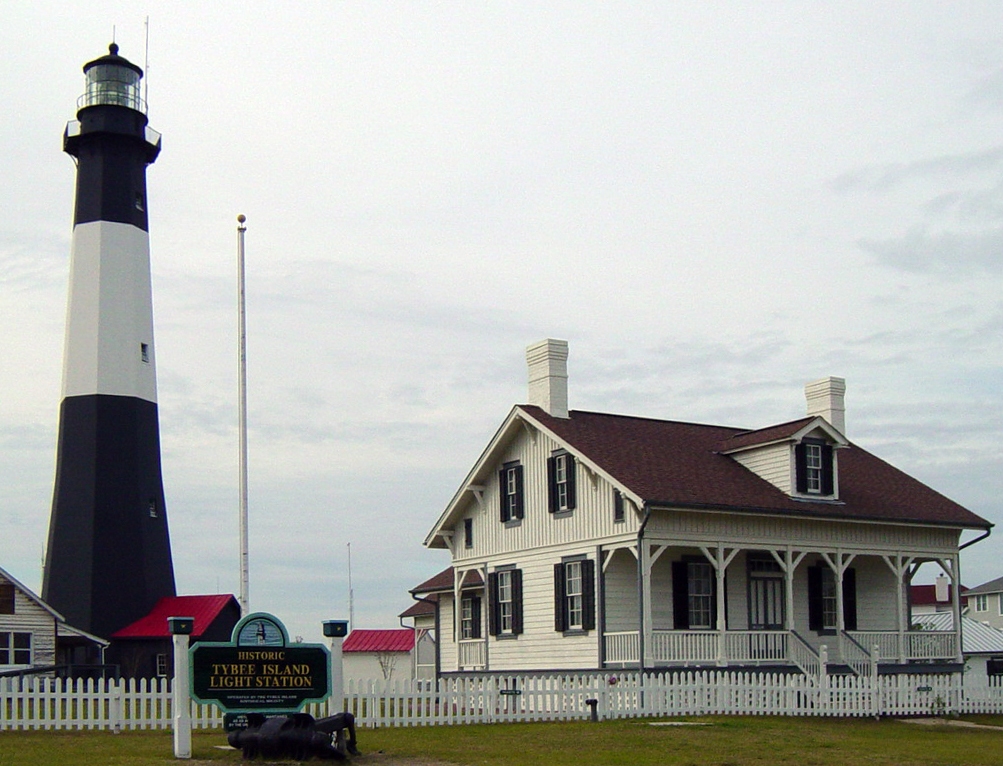


Tybee Island, Georgia
Tybee Island is a city of 3,123 people in Chatham County, Georgia.
Why visit Tybee Island
Townapedia lists 21 museums and landmarks, 11 parks and trails, 38 places to eat, 11 places to stay and 5 attractions in and around town.
Highlights include Tybee Island Lighthouse, Tybee Post Theater, Dutton-Waller Raised Tybee Cottage and Fort Pulaski National Monument.
Weather in Tybee Island
Forecast from the National Weather Service. Full forecast
About Tybee Island
Tybee Island is a city and a barrier island in Chatham County, Georgia, 18 miles (29 km) east of Savannah. The name is used for both the city and the island, but geographically the two are not identical: only part of the island's territory lies within the city, while the rest is unincorporated.
From the Wikipedia article Tybee Island, Georgia (this version), under CC BY-SA 4.0.
Things to do5


Tybee Post Theater
Cinema and theater · 0.9 mi
Movie theater in Tybee Island, Georgia, United States

Cockspur Island Light
Lighthouse · 1.7 mi
Lighthouse in Georgia, United States
Tybee Island Range Front Light
Lighthouse · 3.3 mi
Lighthouse in Georgia, United States
Museums and landmarks21

Dutton-Waller Raised Tybee Cottage
Monument and historic site · National Register of Historic Places · 0.7 mi
Tybee Island, Georgia, NRHP-listed

Fort Pulaski National Monument
Monument and historic site · National Register of Historic Places · 2.4 mi
National monument in the United States


Tybee Island Strand Cottages Historic District
Monument and historic site · National Register of Historic Places · 1.0 mi
Historic district in Georgia, United States

Tybee Island Lighthouse and Museum
Museum · 1.1 mi
Lighthouse in Georgia, United States

9 more on the map.
Parks, trails and playgrounds11



Restaurants and cafes38

Sea Wolf Tybee
Restaurant · 0.6 mi
106 South Campbell Avenue, Tybee Island
Mo-Fr 16:00-22:00; Sa-Su 11:00-22:00


A-J's Dockside Restaurant
Restaurant · 0.8 mi
1315 Chatham Avenue, Tybee Island
Mo,Th,Fr 17:00-21:00; Sa,Su 12:00-21:00
Sting Ray's Seafood
Restaurant · Seafood · 1.1 mi
1403 Butler Avenue, Tybee Island
Tybean Art & Coffee Bar
Cafe · Coffee Shop · 0.8 mi
Mo 07:30-12:30; We-Su 07:30-12:30
26 more on the map.
History
Native Americans, using dugout canoes to navigate the waterways, hunted and camped in Georgia's coastal islands for thousands of years. The Euchee tribe likely inhabited the island in the years preceding the arrival of the first Spanish explorers in the area in the 16th century. Tybee is the Euchee word for "salt".
In 1520, the Spanish laid claim to what is now Tybee Island and named it Los Bajos. It was at the northern end of the Guale missionary province of Spanish Florida. During that time the island was frequented by pirates who used the island to hide from those who pursued them. Pirates later used the island's inland waterways for a fresh water source. After the founding of South Carolina in 1670, warfare increased between the English and their pirate allies and the Spanish and their Native American allies. In 1702, James Moore of South Carolina led an invasion of Spanish Florida with an Indian army and a fleet of militia-manned ships. The invasion failed to take the capital of Florida, St. Augustine, but did destroy the Guale and Mocama missionary provinces. After another invasion of Spanish Florida by South Carolina in 1704, the Spanish retreated to St. Augustine and Pensacola; the Sea Islands were depopulated, allowing the establishment of new English settlements such as the colony of Georgia.
From the History section of Tybee Island, Georgia on Wikipedia, under CC BY-SA 4.0.
Where to stay11
Lighthouse Inn, Bed & Breakfast
Motel and hotel · 1.0 mi
16 Meddin Drive, Tybee Island
Atlantis Inn Tybee Island
Motel and hotel · 1.3 mi
20 Silver Avenue, Tybee Island
Churches and places of worship4
Shopping8
Gas and EV charging3
Schools, colleges and libraries2
Tybee Island Maritime Academy School
School · 0.7 mi
714 Lovell Ave, Tybee Island
Map of Tybee Island
103 places. The map loads OpenStreetMap tiles when you open it.
People and cost of living
American Community Survey 5-year estimates, 2020-2024, U.S. Census Bureau. Estimates have margins of error, larger for small towns.
Disaster history
Chatham County has had 13 federal disaster declarations since 2000, most often for hurricanes.
- 2024-09-30: Hurricane Helene (Hurricane)
- 2024-09-26: Hurricane Helene (Tropical Storm)
- 2024-09-24: Tropical Storm Debby (Tropical Storm)
- 2024-08-05: Hurricane Debby (Tropical Storm)
- 2020-03-29: Covid-19 Pandemic (Biological)
- 2020-03-13: Covid-19 (Biological)
OpenFEMA disaster declarations summaries.
Getting there and nearby towns
Hilton Head Airport (HHH) is the nearest airport with scheduled flights listed in OpenStreetMap, 17 miles away.
- Wilmington Island 7 mi west, about 11 min by car
- Dutch Island 10 mi west, about 17 min by car
- Thunderbolt 11 mi west, about 19 min by car
- Skidaway Island 12 mi southwest, about 20 min by car
- Isle of Hope 12 mi west, about 19 min by car
- Hilton Head Island 14 mi northeast, about 23 min by car
- Bluffton 15 mi north, about 24 min by car
- Montgomery 15 mi west, about 24 min by car
- Savannah 20 mi west, about 32 min by car
- Garden City 20 mi west, about 31 min by car
Drive times are estimates from straight-line distance, not routes.
Local news
Headlines from INDB, the NEMICO news database.
Reviews, tips and questions
Loading what members have shared...
Sources and licences
- NCES EDGE (Public domain): public schools
- OpenFEMA (Public domain): disaster declarations
- OpenStreetMap contributors (ODbL 1.0): places, airports, map data
- U.S. Census Bureau (Public domain): population, income, housing, education, commute
- Wikidata (CC0 1.0): elevation, founding date, time zone, website, landmarks and historic places
- Wikimedia Commons (see each image): photos
- Wikipedia (CC BY-SA 4.0): overview and history text
Photo credits
- Tybee Island Light Station, Timjarrett at English Wikipedia . Later version(s) were uploaded by Jbarta at English Wikipedia ., CC BY-SA 3.0
- Viewing Tybee Island (6549247799), Georgia National Guard from United States, CC BY 2.0
- Tybee Island Post Office, Michael Rivera, CC BY-SA 4.0
- Tybee Island Maritime Academy, Michael Rivera, CC BY-SA 4.0
- Tybee Island Branch Library plaque, Michael Rivera, CC BY-SA 4.0
- Tybee Island Branch Library, Michael Rivera, CC BY-SA 4.0
- Savannah Beach Town Hall, Tybee Island, Georgia, City Hall, Jud McCranie, CC BY-SA 4.0
- Tybee Island City Hall, Michael Rivera, CC BY-SA 4.0
- Tybee Island Light - top, Robert Scrivener III, CC BY 2.0
- Abrahams Raised Cottage, Tybee Island, GA, US, Jud McCranie, CC BY-SA 4.0
- DeSoto Beach Hotel, Tybee Island - panoramio, Scott Long, CC BY 3.0
- FortPulaski02, Edibobb, CC BY 3.0
- Strand Cottages Historic District, Tybee Island, GA, US (13), Bubba73, CC BY-SA 3.0
- GA Tybee Island Dutton-Waller Cottage01, Ebyabe, CC BY-SA 3.0
- All Saints Episcopal Church (Tybee Island) front exterior, Historical-Buff, CC BY-SA 4.0
- Cockspur Island Light, Chatham County, GA, US, Jud McCranie, CC BY-SA 4.0
- Greetings from Savannah Beach, Georgia - Large Letter Postcard (6940827924), Steve Shook from Moscow, Idaho, USA, CC BY 2.0
- Orange crush Fit, Qua Keyz, CC BY-SA 4.0
- James odess o'rourke raised cottage 702 14th ave2, Slowking4, CC BY-SA 3.0
- James odess o'rourke raised cottage 702 14th ave3, Slowking4, CC BY-SA 3.0
- James odess o'rourke raised cottage 702 14th ave, Slowking4, CC BY-SA 3.0
- Savannah (5802337949), Jeff Gunn from Atlanta, USA, CC BY 2.0
- Crassostrea virginica 513022956, ladyjanaye, CC BY 4.0
- Seagulls ^tybeeisland - panoramio, Susan Popielaski, CC BY-SA 3.0
- Flock of Black Skimmers, Bruce Tuten from Savannah, Georgia, United States, CC BY 2.0
- Willet or Catoptrophorus semipalmatus, Bruce Tuten from Savannah, Georgia, United States, CC BY 2.0
- Black Skimmers and Royal Terns, Bruce Tuten from Savannah, Georgia, United States, CC BY 2.0
- Sterna maxima beach3, Bruce Tuten from Savannah, Georgia, United States, CC BY 2.0
- Black Skimmer or "Rynchops niger", Bruce Tuten from Savannah, Georgia, United States, CC BY 2.0
- Black Skimmer immature, Bruce Tuten from Savannah, Georgia, United States, CC BY 2.0
- Sterna maxima beach2, savannahgrandfather, CC BY 2.0
- Sterna maxima young beach4, Bruce Tuten from Savannah, Georgia, United States, CC BY 2.0
- Sterna maxima beach, savannahgrandfather, CC BY 2.0
- Willet or Catoptrophorus semipalmatus3, Bruce Tuten from Savannah, Georgia, United States, CC BY 2.0
- Willet or Catoptrophorus semipalmatus2, Bruce Tuten from Savannah, Georgia, United States, CC BY 2.0
- Greetings from Savannah Beach, Georgia - Large Letter Postcard (6940828788), Steve Shook from Moscow, Idaho, USA, CC BY 2.0
- Fort screven h.d. community center 7510, Slowking4, CC BY-SA 3.0
- Tybe lighthouse7212, Slowking4, CC BY-SA 3.0
- Fort screven h.d. van horne 7482, Slowking4, CC BY-SA 3.0
- Fort screven h.d. van horne 7515, Slowking4, CC BY-SA 3.0


Page built October 30, 2026. Spotted a mistake? Tell us or suggest a place.