


Unalaska, Alaska
Unalaska is a city of 4,556 people in Aleutians West Census Area, Alaska, founded in 1774.
Why visit Unalaska
Townapedia lists 68 museums and landmarks, 11 parks and trails, 5 places to eat, 3 places to stay and 13 attractions in and around town.
Highlights include WWII JIN Crater, WWII JIN Crater, Sitka Spruce Park and Tanaadakuchax Park.
August is the warmest month, with average highs of 59°F; January lows average 29°F, and about 82 inches of snow fall in a normal year.
Weather in Unalaska
Forecast from the National Weather Service. Full forecast
About Unalaska
The City of Unalaska (Aleut: Iluulux̂; Russian: Уналашка) is the main population center in the Aleutian Islands. The city is in the Aleutians West Census Area, a regional component of the Unorganized Borough in the U.S. state of Alaska. Unalaska is located on Unalaska Island and neighboring Amaknak Island in the Aleutian Islands off mainland Alaska. The population was 4,254 at the 2020 census, which is 81% of the entire Aleutians West Census Area.
From the Wikipedia article Unalaska, Alaska (this version), under CC BY-SA 4.0.
Things to do13

1 more on the map.
Museums and landmarks68


SS Northwestern
Monument and historic site · National Register of Historic Places · 6.0 mi
Passenger and freight steamship launched in 1889
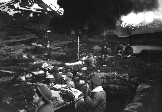
Dutch Harbor Naval Operating Base and Fort Mears, U.S. Army
Monument and historic site · National Register of Historic Places

Aleutian Islands World War II National Historic Area Visitor Center
Museum · 0.8 mi
Used by the Naval Air Transport Service, whose insignia Is inlaid in today's waiting room floor.
Navy no. 618
Monument and historic site · 1.4 mi
The apartment house at the naval radio station. Pre-war construction. Navy no. 618. was said to be the only brick building in the...
56 more on the map.
Parks, trails and playgrounds11
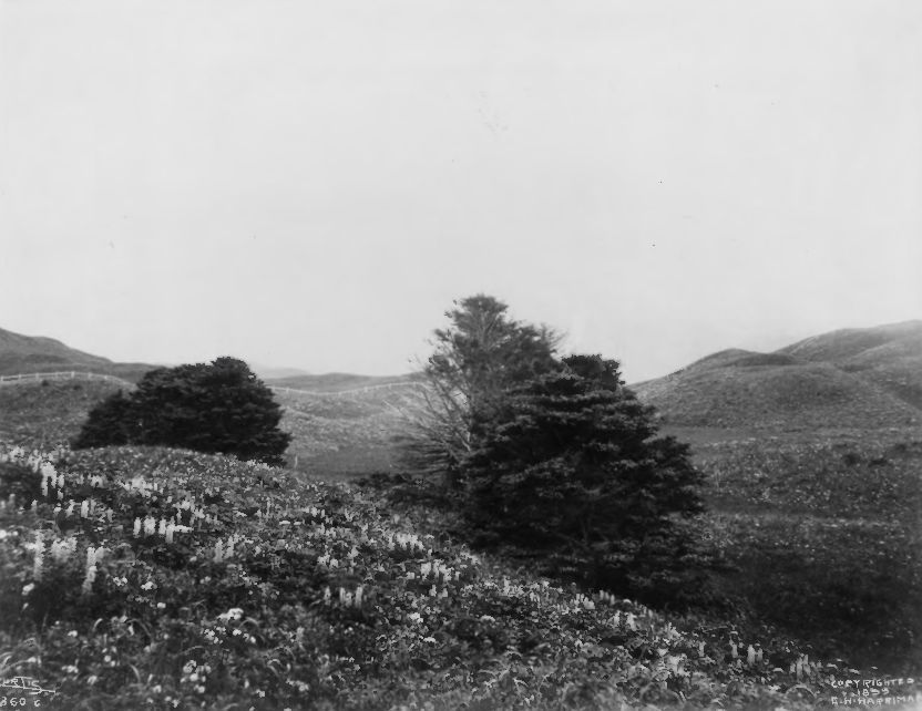


Sitka Spruce Park
Park · National Register of Historic Places · 1.2 mi
Park in United States of America
sunrise-sunset

Tanaadakuchax Park
Park · 2.6 mi
Tanaadakuchax meaning "small land" is the name of the City's smallest park. Tanaadakuchax Park is nestled in Unalaska near the...
sunrise-sunset
Town Park
Park · 2.2 mi
Town Park Town Park, located in downtown Unalaska, was opened by the city in 1988. The park has a beautiful wooden gazebo, two picnic...
sunrise-sunset

Carl E. Moses Boat Harbor (CEM)
Marina and boat launch · 2.6 mi
The Carl E. Moses Boat Harbor (CEM) facility consists of 52 slips and 345 LF. Long-term slips and transient moorage spaces are available...
Robert Storrs Small Boat Harbor
Marina and boat launch · 2.1 mi
The Robert Storrs Small Boat Harbor consists of 1,232 linear feet of floats, comprising 71 slips. Long-term slips and transient moorage...


Restaurants and cafes5

Norwegian Rat Saloon
Bar and pub · 1.6 mi
Local pub Beer & liquor Lunch and dinner TV for sports Corn hole
1906 Airport Beach Road, Dutch Harbor
Mo-Sa 11:30-02:00, Su 12:00-22:00



History
The island of Unalaska was first inhabited by the Aleut people.
Unalaska and Amaknak islands contained 24 settlements with more than 1,000 Aleut inhabitants in 1759, when the first Russian group under Stepan Glotov came and started trading for three years on Umnak and Unalaska. Between 1763 and 1766, a conflict between the Russian fur traders and the Unalaska Natives occurred; the Aleuts destroyed four Russian ships and killed 175 hunters/traders. In the 1760s, Unalaska was temporarily used as a Russian fur trading post. The post was permanently established in 1774, and was eventually incorporated into the Russian-American Company. It was there that Captain James Cook encountered the navigator Gerasim Izmailov in 1778.
In 1788, the Spanish made contact with the Russians in Alaska for the first time. An expedition by Esteban José Martínez and Gonzalo López de Haro visited several Russian settlements. Their westernmost visit was to Unalaska. On August 5, 1788, they claimed Unalaska for Spain, calling it Puerto de Dona Marie Luisa Teresa.
From the History section of Unalaska, Alaska on Wikipedia, under CC BY-SA 4.0.
Where to stay3
Churches and places of worship4
Church of the Holy Ascension
Church · National Register of Historic Places · 2.0 mi
Церковь Вознесения Господня
Church · Russian Orthodox · 2.1 mi
265 West Broadway Ave., Unalaska
Saint Christopher by the Sea Church
Church · Roman Catholic · 2.2 mi
107 Riverside Drive, Unalaska
The Church of Jesus Christ of Latter-day Saints
Church · Mormon · 3.3 mi
187 Steward Road, Unalaska
Shopping1
Schools, colleges and libraries3
Healthcare1
Map of Unalaska
109 places. The map loads OpenStreetMap tiles when you open it.
Climate by month
Monthly table
| Month | High | Low | Rain | Snow |
|---|---|---|---|---|
| Jan | 37°F | 29°F | 6.8 in | 22.0 in |
| Feb | 39°F | 29°F | 5.2 in | 14.2 in |
| Mar | 39°F | 29°F | 4.7 in | 16.5 in |
| Apr | 42°F | 32°F | 3.5 in | 6.3 in |
| May | 47°F | 37°F | 4.2 in | 0.2 in |
| Jun | 52°F | 42°F | 2.5 in | 0.0 in |
| Jul | 57°F | 47°F | 2.3 in | 0.0 in |
| Aug | 59°F | 48°F | 2.9 in | 0.0 in |
| Sep | 55°F | 44°F | 5.7 in | 0.0 in |
| Oct | 48°F | 38°F | 7.9 in | 0.4 in |
| Nov | 43°F | 33°F | 6.7 in | 6.2 in |
| Dec | 39°F | 31°F | 7.9 in | 15.8 in |
U.S. Climate Normals 1991-2020 for Dutch Harbor (1 mi away), NOAA NCEI.
People and cost of living
American Community Survey 5-year estimates, 2020-2024, U.S. Census Bureau. Estimates have margins of error, larger for small towns.
Disaster history
Aleutians West Census Area has had 6 federal disaster declarations since 2000, most often for severe storms.
- 2025-10-22: Severe Storms, Flooding, And Remnants Of Typhoon Halong (Flood)
- 2022-09-23: Severe Storm, Flooding, And Landslides (Severe Storm)
- 2020-04-09: Covid-19 Pandemic (Biological)
- 2020-03-13: Covid-19 (Biological)
- 2016-02-17: Severe Storm (Severe Storm)
- 2004-11-15: Severe Winter Storm, Tidal Surges And Flooding (Severe Storm)
OpenFEMA disaster declarations summaries.
Getting there and nearby towns
Unalaska Airport (DUT) is the nearest airport with scheduled flights listed in OpenStreetMap, 1 miles away.
- Akutan 35 mi northeast, about 57 min by car
Drive times are estimates from straight-line distance, not routes.
Local news
Headlines from INDB, the NEMICO news database.
Reviews, tips and questions
Loading what members have shared...
Sources and licences
- NCES EDGE (Public domain): public schools
- NOAA NCEI U.S. Climate Normals 1991-2020 (Public domain): climate by month
- OpenFEMA (Public domain): disaster declarations
- OpenStreetMap contributors (ODbL 1.0): places, airports, map data
- U.S. Census Bureau (Public domain): population, income, housing, education, commute
- Wikidata (CC0 1.0): elevation, founding date, time zone, website, landmarks and historic places
- Wikimedia Commons (see each image): photos
- Wikipedia (CC BY-SA 4.0): overview and history text
Photo credits
- UnalaskaAlaska, Wanetta Ayers, Public domain
- Unalaska Sunrise (8232704231), Joseph from Cabin On The Road, USA, CC BY-SA 2.0
- Unalaska (8239178495), Joseph from Cabin On The Road, USA, CC BY-SA 2.0
- Unalaska (8240246546), Joseph from Cabin On The Road, USA, CC BY-SA 2.0
- View of Unalaska Island, January 5, 2008, Joseph from Cabin On The Road, USA, CC BY-SA 2.0
- Unalaska Sunrise (8233752180), Joseph from Cabin On The Road, USA, CC BY-SA 2.0
- Unalaska Island (12129632155), Joseph from Cabin On The Road, USA, CC BY-SA 2.0
- Holy Ascension of Our Lord Cathedral, Unalaska, Sonya from Seattle (area), US, CC BY-SA 2.0
- Unalaska banner, Sonya from Seattle (area), US, CC BY-SA 2.0
- View of Unalaska, Sonya from Seattle (area), US, CC BY-SA 2.0
- Holy Ascension of Our Lord Russian Orthodox Church, Unalaska, Alaska, Sonya from Seattle (area), US, CC BY-SA 2.0
- Graveyard of the Holy Ascension of Our Lord Russian Orthodox Church, Unalaska, Alaska, Sonya from Seattle (area), US, CC BY-SA 2.0
- Unalaska (4833012781), Joseph from Cabin On The Road, USA, CC BY-SA 2.0
- Aleut Santa, Unalaska (2188327498), Joseph from Cabin On The Road, USA, CC BY-SA 2.0
- Unalaska Harbor (8230568481), Joseph from Cabin On The Road, USA, CC BY-SA 2.0
- Unalaska (8231637808), Joseph from Cabin On The Road, USA, CC BY-SA 2.0
- View of Unalaska, Alaska, January 3, 2008, Joseph from Cabin On The Road, USA, CC BY-SA 2.0
- Unalaska (8240243158), Joseph from Cabin On The Road, USA, CC BY-SA 2.0
- SitkaSprucePlantation, E. S. Curtis, Public domain
- NorthwesternInFlames-2, US Navy, Public domain
- Unalaska church, Brendan Minish (Flickr user bminish) from Castlebar, Ireland, CC BY 2.0
- DutchHarborMarines, U.S. Navy (photo 80-G-12076), Public domain
- Morning (8232709667), Joseph from Cabin On The Road, USA, CC BY-SA 2.0
- My Ride (8232714381), Joseph from Cabin On The Road, USA, CC BY-SA 2.0
- Toward the Bering Sea (4835737671), Joseph from Cabin On The Road, USA, CC BY-SA 2.0
- Dumpster Eagle (8239178881), Joseph from Cabin On The Road, USA, CC BY-SA 2.0
- Crab Pots in Dutch Harbor Alaska (2190327867), Joseph from Cabin On The Road, USA, CC BY-SA 2.0
- Nets in Dutch Harbor (5079049258), Joseph from Cabin On The Road, USA, CC BY-SA 2.0
- Dutch harbor,alaska - panoramio, Leo Macias, CC BY-SA 3.0
- Crab Pots (8232678417), Joseph from Cabin On The Road, USA, CC BY-SA 2.0
- Platanthera Convallariifolia, Jason Grant, CC BY 4.0
- Mount Newhall, Sonya, CC BY-SA 2.0
- Offloading crab in Dutch Harbor, Sonya from Seattle (area), US, CC BY-SA 2.0
- Grand Aleutian Hotel (8231921168), Joseph from Cabin On The Road, USA, CC BY-SA 2.0
- Aleutian Eagle (2188327494), Joseph from Cabin On The Road, USA, CC BY-SA 2.0
- Repairing Nets (4835735781), Joseph from Cabin On The Road, USA, CC BY-SA 2.0
- World War II Bunker, Dutch Harbor (8230557573), Joseph from Cabin On The Road, USA, CC BY-SA 2.0
- Eagle in Dutch Harbor in front of fish totes (4833016037), Joseph from Cabin On The Road, USA, CC BY-SA 2.0
- Dutch Harbor Pollock Fishing Vessels (4833684520), Joseph from Cabin On The Road, USA, CC BY-SA 2.0


Page built October 30, 2026. Spotted a mistake? Tell us or suggest a place.