


Union Bridge, Maryland
Union Bridge is a town of 1,055 people in Carroll County, Maryland, founded in 1872.
Why visit Union Bridge
Townapedia lists 12 museums and landmarks, 1 park or trail and 3 places to eat in and around town.
Highlights include Appler-Englar House and Hard Lodging.
July is the warmest month, with average highs of 85°F; January lows average 22°F, and about 28 inches of snow fall in a normal year.
Weather in Union Bridge
Forecast from the National Weather Service. Full forecast
About Union Bridge
Union Bridge is a town in Carroll County, Maryland, United States. The population was 936 at the 2020 census.
From the Wikipedia article Union Bridge, Maryland (this version), under CC BY-SA 4.0.
Museums and landmarks12
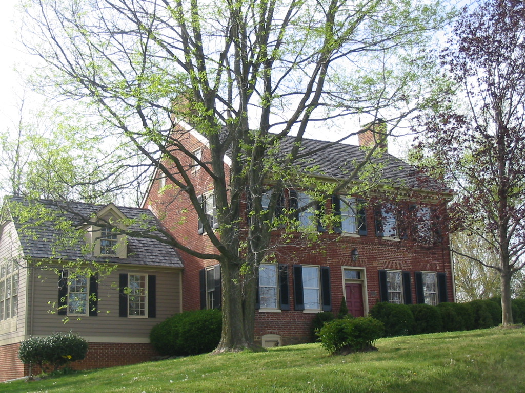
Appler-Englar House
Monument and historic site · National Register of Historic Places · 2.7 mi
House in Carroll County, Maryland

Hard Lodging
Monument and historic site · National Register of Historic Places · 0.5 mi
Building in Maryland, United States

Hopewell
Monument and historic site · National Register of Historic Places · 2.8 mi
Historic site in Union Bridge, Maryland, United States

Jacob Koons Farm
Monument and historic site · National Register of Historic Places · 2.7 mi
Historic farmstead in rural Carroll County, Maryland

Linwood Historic District
Monument and historic site · National Register of Historic Places · 1.8 mi
Historic district in Linwood, Maryland

McKinstry's Mills Historic District
Monument and historic site · National Register of Historic Places · 2.5 mi
Historic district in Maryland, United States
Mount Pleasant
Monument and historic site · National Register of Historic Places · 0.6 mi
Historic home located at Union Bridge, Carroll County, Maryland, United States


Stoner-Saum Farm
Monument and historic site · National Register of Historic Places · 2.5 mi
Building in Maryland, United States
Union Bridge Historic District
Monument and historic site · National Register of Historic Places · 0.4 mi
Union Bridge, Maryland
Union Bridge Station
Monument and historic site · National Register of Historic Places
Railway station in Union Bridge, the United States of America
Wilson's Inheritance
Monument and historic site · National Register of Historic Places · 0.7 mi
Building in Maryland, United States

Western Maryland Railroad Museum
Museum
41 North Main Street, Union Bridge
We 09:00-11:30,12:30-15:00; Su 13:00-16:00
Parks, trails and playgrounds1

Restaurants and cafes3

Original Pizza
Restaurant · Pizza, Italian
2 South Main Street, Union Bridge
We-Th 11:00-20:00; Fr-Sa 11:00-21:00; Su 11:00-20:00

Flood Zone Marketplace & Brewery
Brewery and winery
50 North Main Street, Union Bridge
We-Th 16:00-21:00; Fr 15:00-22:00; Sa 12:00-22:00; Su 12:00-19:00
Churches and places of worship8

Pipe Creek Friends Meetinghouse
Church · National Register of Historic Places · 0.5 mi
Church building in Maryland, United States of America
Saint James Lutheran Church
Church · Lutheran
14 South Benedum Street, Union Bridge
Schools, colleges and libraries6
Healthcare1
Map of Union Bridge
31 places. The map loads OpenStreetMap tiles when you open it.
Climate by month
Monthly table
| Month | High | Low | Rain | Snow |
|---|---|---|---|---|
| Jan | 40°F | 22°F | 3.5 in | 8.7 in |
| Feb | 43°F | 23°F | 2.5 in | 8.8 in |
| Mar | 52°F | 30°F | 4.2 in | 4.4 in |
| Apr | 64°F | 40°F | 3.9 in | 0.2 in |
| May | 72°F | 50°F | 4.3 in | 0.0 in |
| Jun | 81°F | 60°F | 4.3 in | 0.0 in |
| Jul | 85°F | 64°F | 4.3 in | 0.0 in |
| Aug | 84°F | 62°F | 3.5 in | 0.0 in |
| Sep | 77°F | 55°F | 5.2 in | 0.0 in |
| Oct | 66°F | 44°F | 3.8 in | 0.1 in |
| Nov | 54°F | 33°F | 3.4 in | 0.8 in |
| Dec | 44°F | 27°F | 3.8 in | 4.5 in |
U.S. Climate Normals 1991-2020 for Emmitsburg 2 Se (9 mi away), NOAA NCEI.
People and cost of living
American Community Survey 5-year estimates, 2020-2024, U.S. Census Bureau. Estimates have margins of error, larger for small towns.
Disaster history
Carroll County has had 12 federal disaster declarations since 2000, most often for hurricanes.
- 2026-01-24: Severe Winter Storm (Winter Storm)
- 2020-03-26: Covid-19 Pandemic (Biological)
- 2020-03-13: Covid-19 (Biological)
- 2016-03-04: Severe Winter Storm And Snowstorm (Snowstorm)
- 2014-04-10: Snowstorm (Severe Storm)
- 2012-11-20: Hurricane Sandy (Hurricane)
OpenFEMA disaster declarations summaries.
Getting there and nearby towns
Frederick Municipal Airport (FDK) is the nearest airport with scheduled flights listed in OpenStreetMap, 15 miles away.
- New Windsor 4 mi southeast, about 7 min by car
- Taneytown 6 mi north, about 10 min by car
- Libertytown 7 mi southwest, about 12 min by car
- Westminster 9 mi east, about 14 min by car
- Walkersville 12 mi southwest, about 20 min by car
- Emmitsburg 12 mi northwest, about 20 min by car
- Linganore 13 mi southwest, about 21 min by car
- Thurmont 13 mi west, about 21 min by car
- Mount Airy 14 mi south, about 22 min by car
- Frederick 16 mi southwest, about 25 min by car
Drive times are estimates from straight-line distance, not routes.
Local news
Headlines from INDB, the NEMICO news database.
Reviews, tips and questions
Loading what members have shared...
Sources and licences
- NCES EDGE (Public domain): public schools
- NOAA NCEI U.S. Climate Normals 1991-2020 (Public domain): climate by month
- OpenFEMA (Public domain): disaster declarations
- OpenStreetMap contributors (ODbL 1.0): places, airports, map data
- U.S. Census Bureau (Public domain): population, income, housing, education, commute
- Wikidata (CC0 1.0): elevation, founding date, time zone, website, landmarks and historic places
- Wikimedia Commons (see each image): photos
- Wikipedia (CC BY-SA 4.0): overview and history text
Photo credits
- Union Bridge MD, Ottava Rima, CC BY-SA 3.0
- 2016-08-20 18 21 16 View north along Maryland State Route 75 (Green Valley Road) at Main Street in Union Bridge, Carroll County, Maryland, Famartin, CC BY-SA 4.0
- 2016-08-20 18 15 08 View south along Maryland State Route 75 (Main Street) between Little Pipe Creek and Elger Street in Union Bridge, Carroll County, Maryland, Famartin, CC BY-SA 4.0
- 2016-08-20 18 15 12 View south along Maryland State Route 75 (Main Street) between Little Pipe Creek and Elger Street in Union Bridge, Carroll County, Maryland, Famartin, CC BY-SA 4.0
- Union Bridge WMRR Station, Acroterion, CC BY-SA 4.0
- 2016-08-20 18 15 15 View south along Maryland State Route 75 (Main Street) at a railroad crossing between Little Pipe Creek and Elger Street in Union Bridge, Carroll County, Maryland, Famartin, CC BY-SA 4.0
- 2016-08-20 18 14 37 View south along Maryland State Route 75 (Main Street) at Green Valley Road in Union Bridge, Carroll County, Maryland, Famartin, CC BY-SA 4.0
- 2016-08-20 18 20 06 View north along Maryland State Route 75 (Main Street) at Elger Street in Union Bridge, Carroll County, Maryland, Famartin, CC BY-SA 4.0
- 2016-08-20 18 15 24 View south along Maryland State Route 75 (Main Street) at Elger Street in Union Bridge, Carroll County, Maryland, Famartin, CC BY-SA 4.0
- Union Bridge HD MD1, Acroterion, CC BY-SA 4.0
- Union Bridge HD MD4, Acroterion, CC BY-SA 4.0
- 2016-08-20 18 15 30 View south along Maryland State Route 75 (Main Street) between Elger Street and Broadway Street in Union Bridge, Carroll County, Maryland, Famartin, CC BY-SA 4.0
- 2016-08-20 18 19 52 View north along Maryland State Route 75 (Main Street) at Broadway Street in Union Bridge, Carroll County, Maryland, Famartin, CC BY-SA 4.0
- 2016-08-20 18 19 10 View north along Maryland State Route 75 (Main Street) at Thomas Street in Union Bridge, Carroll County, Maryland, Famartin, CC BY-SA 4.0
- Union Bridge HD MD2, Acroterion, CC BY-SA 4.0
- Union Bridge HD MD3, Acroterion, CC BY-SA 4.0
- 2016-08-20 18 18 55 View north along Maryland State Route 75 (Main Street) between Stoner Street and Locust Street in Union Bridge, Carroll County, Maryland, Famartin, CC BY-SA 4.0
- 2020-06-17 10 30 59 View south along Maryland State Route 75 (Green Valley Road) at Church Street in Union Bridge, Carroll County, Maryland, Famartin, CC BY-SA 4.0
- Mt. Pleasant, Union Bridge 2009, Acroterion, CC BY-SA 4.0
- 2016-08-20 18 17 23 View north along Maryland State Route 75 (Green Valley Road) just north of Sams Creek and just south of Union Bridge in Carroll County, Maryland, Famartin, CC BY-SA 4.0
- Union Bridge cement kiln tower MD1, Acroterion, CC BY-SA 4.0
- Hopewell MD1, Acroterion, CC BY-SA 4.0
- McKinstry's Mill MD2, Acroterion, CC BY-SA 4.0
- Appler-Englar House, Chwatk7351, CC BY-SA 4.0
- Jacob Koons Farm MD1, Acroterion, CC BY-SA 4.0
- Stoner-Saum Farm MD1, Acroterion, CC BY-SA 4.0
- Linwood Historic District, Franz Farm (21416099389), Preservation Maryland, CC BY-SA 2.0
- Limenitis arthemis astyanax 721351776, Ken Clark, CC BY 4.0
- Bornite (33892149198), Pacific Museum of Earth from Canada, CC BY-SA 2.0
- Pipe Creek Friends Meetinghouse, Acroterion, CC BY-SA 4.0
- Hard Lodging 2009, Acroterion, CC BY-SA 4.0
- Wilson's Inheritance, Chwatk7351, CC BY-SA 4.0
- 2020-06-17 10 36 35 View north along Maryland State Route 75 (Green Valley Road) at Shepherds Mill Road and Stern Road in Linwood, Carroll County, Maryland, Famartin, CC BY-SA 4.0
- 2020-06-17 10 21 22 View east along Maryland State Route 800 (Watson Lane) at Maryland State Route 75 (Green Valley Road) near the Wolf Pit Branch of Little Pipe Creek in Linwood, Carroll County..., Famartin, CC BY-SA 4.0
- 2016-08-20 18 29 54 View east along Maryland State Route 800 (Watson Lane) at Maryland State Route 75 (Green Valley Road) near the Wolf Pit Branch of Little Pipe Creek in Linwood, Carroll County..., Famartin, CC BY-SA 4.0


Page built October 30, 2026. Spotted a mistake? Tell us or suggest a place.