


Upland, California
Upland is a city of 79,257 people in San Bernardino County, California.
Why visit Upland
Townapedia lists 26 museums and landmarks, 54 parks and trails, 296 places to eat, 2 places to stay and 8 attractions in and around town.
Highlights include Claremont Graduate University, Claremont Lincoln University, John Rains House and Scripps College.
August is the warmest month, with average highs of 95°F; December lows average 44°F.
Weather in Upland
Forecast from the National Weather Service. Full forecast
About Upland
Upland is a city in the Inland Empire region of San Bernardino County, California, United States, on the border with neighboring Los Angeles County. The municipality is located at an elevation of 1,242 feet (379 m). As of the 2020 census, the city had a population of 79,040, up from 73,732 at the 2010 census.
From the Wikipedia article Upland, California (this version), under CC BY-SA 4.0.
Things to do8

Claremont Graduate University
School · 3.1 mi
University located in Claremont, California, United States

Regal Edwards Ontario Mountain Village
Cinema and theater · 2.1 mi
1575 North Mountain Avenue, Ontario

Museums and landmarks26

John Rains House
Monument and historic site · National Register of Historic Places · 2.9 mi
Historic house in California, United States

Scripps College
Monument and historic site · National Register of Historic Places · 3.0 mi
Women's college in Claremont, California

Claremont
Monument and historic site · National Register of Historic Places · 3.6 mi
Railway station in California, United States

Cucamonga Service Station
Monument and historic site · National Register of Historic Places · 3.8 mi
U.S. Route 66 Building in California

Frankish Building
Monument and historic site · National Register of Historic Places · 3.7 mi
Building in Ontario, United States of America

Old Carnegie Library
Monument and historic site · National Register of Historic Places · 1.4 mi
Library building in Upland, California, United States

Old San Antonio Hospital
Monument and historic site · National Register of Historic Places · 1.2 mi
Hospital in California, United States

Ontario State Bank Block
Monument and historic site · National Register of Historic Places · 3.8 mi
Bank building in Ontario, California

Padua Hills Theatre
Cinema and theater · National Register of Historic Places · 3.4 mi
Former theater in Claremont, California, United States, featuring Mexican-theme musicals (1931-1974)

Russian Village District
Monument and historic site · National Register of Historic Places · 3.2 mi
Historic district in California, United States
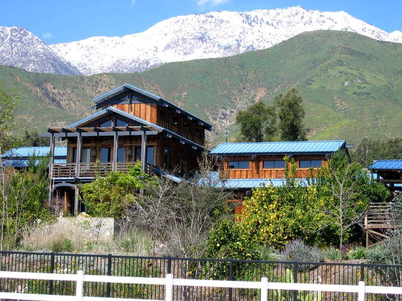
Sam and Alfreda Maloof Compound
Monument and historic site · National Register of Historic Places · 4.0 mi
Home and studio complex in Rancho Cucamonga, California, USA


Ygnacio Palomares Adobe
Monument and historic site · National Register of Historic Places · 5.1 mi
Historic house in California, United States
14 more on the map.
Parks, trails and playgrounds54




Robert J. Bernard Biological Field Station
Hiking and trails · 2.9 mi
42 more on the map.
Restaurants and cafes296


Red Devil Pizza
Restaurant · Pizza · 0.6 mi
907 Foothill Boulevard
Mo-Th 11:00-21:00; Fr-Sa 11:00-22:30; Su 11:00-20:30
Round Table Pizza
Restaurant · Pizza · 1.3 mi
830 East Foothill Boulevard, Upland
Su-Th 11:00-22:00; Fr-Sa 11:00-23:00

Klatch Coffee
Cafe · 2.9 mi
8916 Foothill Boulevard, Rancho Cucamonga
Mo-We 06:30-21:00; Th-Fr 06:30-22:00; Sa 07:00-22:00; Su 07:30-21:00

Molly's Souper
Diner · American · 1.4 mi
388 N First Street
Mo-Su 06:00-14:00
Pho Spot
Restaurant · Vietnamese · 2.7 mi
8802 Base Line Road, Rancho Cucamonga
Mo-Sa 10:30-20:00; Su off
Royaltea
Cafe · Bubble Tea · 2.9 mi
8005 Vineyard Avenue, Rancho Cucamonga
Tu-Su 13:00-22:00
284 more on the map.
Where to stay2
Churches and places of worship56
Monte Vista Unitarian Universalist Congregation
Place of worship · 2.9 mi
9185 Monte Vista Avenue, Montclair
The Church of Jesus Christ of Latter-day Saints
Church · Mormon · 2.9 mi
701 East Rosewood Court, Ontario
Shopping54
Gas and EV charging20
Schools, colleges and libraries97
Healthcare26
Conscious Behavioral Health
Clinic and pharmacy · 0.6 mi
955 W Foothill Blvd, Upland
Map of Upland
250 places. The map loads OpenStreetMap tiles when you open it.
Climate by month
Monthly table
| Month | High | Low | Rain |
|---|---|---|---|
| Jan | 68°F | 45°F | 2.6 in |
| Feb | 68°F | 46°F | 3.1 in |
| Mar | 72°F | 49°F | 1.6 in |
| Apr | 76°F | 51°F | 0.8 in |
| May | 80°F | 56°F | 0.3 in |
| Jun | 86°F | 60°F | 0.0 in |
| Jul | 94°F | 65°F | 0.1 in |
| Aug | 95°F | 65°F | 0.0 in |
| Sep | 91°F | 64°F | 0.1 in |
| Oct | 83°F | 57°F | 0.4 in |
| Nov | 75°F | 49°F | 0.8 in |
| Dec | 67°F | 44°F | 1.9 in |
U.S. Climate Normals 1991-2020 for Ontario Intl Ap (5 mi away), NOAA NCEI.
People and cost of living
American Community Survey 5-year estimates, 2020-2024, U.S. Census Bureau. Estimates have margins of error, larger for small towns.
Disaster history
San Bernardino County has had 40 federal disaster declarations since 2000, most often for fires.
- 2024-09-11: Bridge Fire (Fire)
- 2024-09-07: Line Fire (Fire)
- 2023-04-03: Severe Winter Storms, Straight-Line Winds, Flooding, Landslides, And Mudslides (Severe Storm)
- 2023-03-10: Severe Winter Storms, Flooding, Landslides, And Mudslides (Flood)
- 2023-01-09: Severe Winter Storms, Flooding, And Mudslides (Flood)
- 2020-10-26: Blue Ridge Fire (Fire)
OpenFEMA disaster declarations summaries.
Getting there and nearby towns
Cable Airport (CCB) is the nearest airport with scheduled flights listed in OpenStreetMap, 2 miles away.
- Claremont 3 mi west, about 5 min by car
- San Antonio Heights 3 mi north, about 4 min by car
- Montclair 4 mi southwest, about 6 min by car
- Rancho Cucamonga 5 mi east, about 9 min by car
- Ontario 6 mi southeast, about 10 min by car
- La Verne 6 mi west, about 10 min by car
- Pomona 7 mi southwest, about 11 min by car
- San Dimas 9 mi west, about 14 min by car
- Chino 10 mi south, about 16 min by car
- Fontana 11 mi east, about 18 min by car
Drive times are estimates from straight-line distance, not routes.
Local news
Headlines from INDB, the NEMICO news database.
Reviews, tips and questions
Loading what members have shared...
Sources and licences
- NCES EDGE (Public domain): public schools
- NOAA NCEI U.S. Climate Normals 1991-2020 (Public domain): climate by month
- OpenFEMA (Public domain): disaster declarations
- OpenStreetMap contributors (ODbL 1.0): places, airports, map data
- U.S. Census Bureau (Public domain): population, income, housing, education, commute
- Wikidata (CC0 1.0): elevation, founding date, time zone, website, landmarks and historic places
- Wikimedia Commons (see each image): photos
- Wikipedia (CC BY-SA 4.0): overview and history text
Photo credits
- Foothill Rout 66 Upland - panoramio, beglib, CC BY-SA 3.0
- The Hat, Upland, VirtualErn, CC BY 2.0
- From Upland to the Mountains - panoramio, Johnwayne Stroud, CC BY-SA 3.0
- Madonna of the Trail, Upland, California, Laurie Losh Babcock ; sculptor August Leimbach, Public domain
- This is a photo of a place or building that is listed on the California Historical Landmark listing in the United States. Its reference number is, August Leimbach (1882-1965), CC BY-SA 4.0
- This is a photo of a place or building that is listed on the California Historical Landmark listing in the United States. Its reference number is, August Leimbach (1882-1965), CC BY-SA 4.0
- This is a photo of a place or building that is listed on the California Historical Landmark listing in the United States. Its reference number is, August Leimbach (1882-1965), CC BY-SA 4.0
- This is a photo of a place or building that is listed on the California Historical Landmark listing in the United States. Its reference number is, August Leimbach (1882-1965), CC BY-SA 4.0
- This is a photo of a place or building that is listed on the California Historical Landmark listing in the United States. Its reference number is, August Leimbach (1882-1965), CC BY-SA 4.0
- Outback Steakhouse Upland, MrbignatedogYT, CC0
- Upland baseline benson pump house DSC 7784, Seauton , 28 July 2026, CC BY 4.0
- Upland baseline benson pump house DSC 7782, Seauton , 28 July 2026, CC BY 4.0
- Upland baseline benson pump house DSC 7781, Seauton , 28 July 2026, CC BY 4.0
- Upland Public Library and fire station (circa 1915) courtesy of Upland Public Library, Publisher: Upland Public Library Contributor: Unknown Date: circa 1915, Public domain
- John Rains House 2, Einbierbitte, CC BY-SA 4.0
- Scripps College for Women-9, Lure Photography, CC BY-SA 3.0
- Padua Hills Theatre 007, Einbierbitte, CC BY-SA 4.0
- Claremont station (California), March 2025, OrdinaryScarlett, CC0
- Adobe de Palomares, Los Angeles, CC BY-SA 3.0
- Cucamonga Service Station 3, Einbierbitte, CC BY-SA 4.0
- Frankish Bldg 7, Einbierbitte, CC BY-SA 4.0
- Russian Village Historic District, Claremont, Los Angeles, CC BY-SA 3.0
- OldSanAntonioHospital, NoBozos, CC0
- MaloofHouse, Bill W Ca at English Wikipedia, Public domain
- Ontario State Bank Block nom1 - Ontario California, Stephen Hammond, California Department of Transportation, Public domain
- Pastrami from The Hat, antmang, CC BY 2.0
- Pastrami and fries from The Hat, trendywendy, CC BY-SA 2.0
- Inscription Madonna of the Trail - panoramio, Johnwayne Stroud, CC BY-SA 3.0
- California Landmark No. 1028 Madonna of the Trail - panoramio, Johnwayne Stroud, CC BY-SA 3.0
- Quartersawn White Hard Sugar Maple wood blank, Stephen Ondich, CC BY-SA 3.0
- JS Atwal in 2021, Rammehar1313, CC BY-SA 4.0
- Hawaiian Koa Micro Slab, Stephen Ondich, CC BY-SA 4.0
- Flamed Quartersawn Ash Guitar Top, Stephen Ondich, CC BY-SA 4.0
- 210 ^ San Antonio - panoramio, beglib, CC BY-SA 3.0
- 05491-Hollywood-1904-Residence of Wm. H. Hoegee-Brück & Sohn Kunstverlag, Brück & Sohn Kunstverlag Meißen, CC0
- 04901-Hollywood-1903-Residence of Paul de Longpre-Brück & Sohn Kunstverlag, Brück & Sohn Kunstverlag Meißen, CC0
- Outback Steakhouse SoCal, MrbignatedogYT, CC0
- City Hall Plaza - panoramio, Jordan W., CC BY-SA 3.0
- Cable airport rock buildings DSC 7779, Seauton, CC BY 4.0
- Cable airport wide DSC 7777, Seauton , 28 July 2026, CC BY 4.0


Page built October 30, 2026. Spotted a mistake? Tell us or suggest a place.