
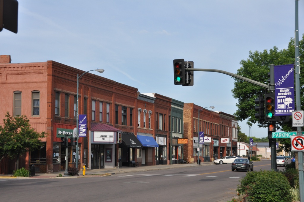


Vermillion, South Dakota
Vermillion is a city of 11,878 people in Clay County, South Dakota, founded in 1859.
Why visit Vermillion
Townapedia lists 18 museums and landmarks, 13 parks and trails, 46 places to eat, 4 places to stay and 4 attractions in and around town.
Highlights include Coyote Theatre, National Music Museum, Downtown Vermillion Historic District and DakotaDome.
July is the warmest month, with average highs of 86°F; January lows average 10°F.
Weather in Vermillion
Forecast from the National Weather Service. Full forecast
About Vermillion
Vermillion (Lakota: Waséoyuze; "The Place Where Vermilion is Obtained") is a city in and the county seat of Clay County. It is in the southeastern corner of South Dakota, United States, and is the state's 12th-most populous city. According to the 2020 census, the population was 11,695. The city lies atop a bluff near the Missouri River.
From the Wikipedia article Vermillion, South Dakota (this version), under CC BY-SA 4.0.
Things to do4

Wayne S. Knutson Theatre
Cinema and theater · 0.5 mi
414 East Clark Street, Vermillion
Museums and landmarks18


Downtown Vermillion Historic District
Monument and historic site · National Register of Historic Places
Historic district in Vermillion, South Dakota

Austin–Whittemore House
Monument and historic site · National Register of Historic Places · 0.5 mi
Historic house in South Dakota, United States

Belbas Center
Monument and historic site · National Register of Historic Places
Arsenal in Vermillion, South Dakota
Bluff View Cemetery Chapel
Monument and historic site · National Register of Historic Places · 1.2 mi
Historic chapel in Vermillion, South Dakota

Clay County Courthouse
Monument and historic site · National Register of Historic Places · 0.5 mi
Historic courthouse in Vermillion, South Dakota, USA

First National Bank Building of Vermillion
Monument and historic site · National Register of Historic Places
Bank building in Vermillion, South Dakota

Gunderson House
Monument and historic site · National Register of Historic Places
Historic house in Vermillion, South Dakota, United States

Inman House
Monument and historic site · National Register of Historic Places
House in Vermillion, South Dakota

Linden House
Monument and historic site · National Register of Historic Places · 0.6 mi
Historic house in South Dakota, United States
Old Main
Monument and historic site · National Register of Historic Places
Historic building in Vermillion, South Dakota, United States


St. Agnes Catholic Church
Monument and historic site · National Register of Historic Places · 0.4 mi
Church building in South Dakota, United States of America
6 more on the map.
Parks, trails and playgrounds13



1 more on the map.
Restaurants and cafes46

Café Brulé
Restaurant · French, American, Bakery, Sandwich, Burger, Coffee Shop · 0.4 mi
24 West Main Street, Vermillion
Mo-Su 08:00-20:00
RED Steakhouse
Restaurant · Burger, Steak House, American · 0.4 mi
1 East Main Street, Vermillion
Tu-Th 11:00-21:00; Fr 11:00-22:00; Sa 08:00-22:00

The Bean - Community Coffeehouse
Cafe · Coffee Shop · 0.4 mi
8 West Main Street, Vermillion
Su 12:00-17:00; Tu-Fr 07:00-18:00; Sa 08:00-17:00

Carey's Bar
Bar and pub · 0.4 mi
18 West Main Street, Vermillion
Mo-Fr 12:00-02:00; Sa 10:30-02:00; Su 15:00-02:00
Dakota Brick House
Bar and pub · 0.4 mi
15 West Main Street, Vermillion
Mo-Th 17:00-24:00; Fr-Sa 17:00-02:00
Bunyan's
Bar and pub · American · 1.2 mi
1201 West Main Street, Vermillion
Mo-Su 12:00-00:00
Latte Da
Cafe · Coffee Shop, Bagel, Sandwich · 0.4 mi
709 East Cherry Street, Vermillion
Mo-Th 06:30-19:00; Fr 06:30-17:00
Pizza Hut
Restaurant · Pizza · 0.6 mi
928 East Cherry Street, Vermillion
Su-Th 11:00-22:00; Fr-Sa 11:00-23:00

Valiant Vineyards Winery
Brewery and winery · 1.4 mi
1500 West Main Street, Vermillion
Su-We 11:00-13:00; Th-Sa 11:00-17:00
Bru2 Coffeehouse
Cafe · Coffee Shop · 0.7 mi
1110 East Cherry Street, Vermillion
Mo-Fr 06:30-18:00; Sa 08:00-16:00
34 more on the map.
History
The area has been home to Native American tribes for centuries. In the late 1700s, the Sioux nations were driven from Minnesota to Dakota, and the Yankton Sioux cultivated corn and stored supplies near where Vermillion would be founded.
French fur traders came to the site in the late 18th century. Lewis and Clark camped at the mouth of the Vermillion River near the present-day town on August 24, 1804. The previous day, they had killed their first bison; the next day, they climbed Spirit Mound. By the 1820s the Missouri River had become a key route for fur traders and the Columbia Fur Company built a post near where the Vermillion River met the Missouri River's old channel just south of the bluffs. In May 1843, John James Audubon visited the Vermillion ravine to view the bird life.
From the History section of Vermillion, South Dakota on Wikipedia, under CC BY-SA 4.0.
Where to stay4
Churches and places of worship7
First Baptist Church of Vermillion
Church · National Register of Historic Places
First Methodist Episcopal Church
Church · National Register of Historic Places
Saint Thomas More Newman Center
Church · Catholic
320 East Cherry Street, Vermillion
The Church of Jesus Christ of Latter-day Saints
Church · Mormon · 1.0 mi
20 South Mickelson Avenue, Vermillion
Shopping9
Gas and EV charging3
Schools, colleges and libraries14
Vermillion Area Alternative School
School · 0.5 mi
East Cherry Street, Vermillion
Healthcare3
Map of Vermillion
121 places. The map loads OpenStreetMap tiles when you open it.
Climate by month
Monthly table
| Month | High | Low | Rain |
|---|---|---|---|
| Jan | 30°F | 10°F | 0.5 in |
| Feb | 36°F | 14°F | 0.7 in |
| Mar | 48°F | 25°F | 1.4 in |
| Apr | 62°F | 36°F | 3.1 in |
| May | 73°F | 48°F | 4.0 in |
| Jun | 82°F | 59°F | 4.3 in |
| Jul | 86°F | 63°F | 3.6 in |
| Aug | 83°F | 61°F | 2.9 in |
| Sep | 78°F | 52°F | 3.1 in |
| Oct | 65°F | 38°F | 2.4 in |
| Nov | 48°F | 25°F | 1.3 in |
| Dec | 34°F | 15°F | 0.8 in |
U.S. Climate Normals 1991-2020 for Vermillion 2 Se Hcn (1 mi away), NOAA NCEI.
People and cost of living
American Community Survey 5-year estimates, 2020-2024, U.S. Census Bureau. Estimates have margins of error, larger for small towns.
Disaster history
Clay County has had 12 federal disaster declarations since 2000, most often for floods.
- 2024-08-15: Severe Storms, Straight-Line Winds, And Flooding (Flood)
- 2022-06-29: Severe Storm, Straight-Line Winds, Tornadoes, And Flooding (Severe Storm)
- 2020-04-05: Covid-19 Pandemic (Biological)
- 2020-03-13: Covid-19 (Biological)
- 2019-06-07: Severe Winter Storm, Snowstorm, And Flooding (Flood)
- 2014-07-28: Severe Storms, Tornadoes, And Flooding (Flood)
OpenFEMA disaster declarations summaries.
Getting there and nearby towns
Chan Gurney Municipal Airport (YKN) is the nearest airport with scheduled flights listed in OpenStreetMap, 25 miles away.
- Newcastle 9 mi south, about 15 min by car
- Elk Point 14 mi southeast, about 23 min by car
- Gayville 15 mi northwest, about 23 min by car
- Wakonda 18 mi northwest, about 29 min by car
- Akron 19 mi east, about 31 min by car
- Ponca 19 mi southeast, about 30 min by car
- Sioux City 34 mi southeast, about 54 min by car
- South Sioux City 34 mi southeast, about 55 min by car
- Le Mars 38 mi east, about 1 h by car
- Sioux Falls 53 mi north, about 1 h 30 min by car
Drive times are estimates from straight-line distance, not routes.
Local news
Headlines from INDB, the NEMICO news database.
Reviews, tips and questions
Loading what members have shared...
Sources and licences
- NCES EDGE (Public domain): public schools
- NOAA NCEI U.S. Climate Normals 1991-2020 (Public domain): climate by month
- OpenFEMA (Public domain): disaster declarations
- OpenStreetMap contributors (ODbL 1.0): places, airports, map data
- U.S. Census Bureau (Public domain): population, income, housing, education, commute
- Wikidata (CC0 1.0): elevation, founding date, time zone, website, landmarks and historic places
- Wikimedia Commons (see each image): photos
- Wikipedia (CC BY-SA 4.0): overview and history text
Photo credits
- VermilionSD Downtown, User:Magicpiano, CC BY-SA 4.0
- National Music Museum, Vermillion, South Dakota (4838479111), David Becker, CC BY 2.0
- National Music Museum, Vermillion, South Dakota (4839093718), David Becker, CC BY 2.0
- National Music Museum, Vermillion, South Dakota (4839101942), David Becker, CC BY 2.0
- National Music Museum, Vermillion, South Dakota (4838476173), David Becker, CC BY 2.0
- National Music Museum, Vermillion, South Dakota (4839091668), David Becker, CC BY 2.0
- National Music Museum, Vermillion, South DakotaNational Music Museum, Vermillion, South Dakota (4839089778), David Becker, CC BY 2.0
- National Music Museum, Vermillion, South Dakota (4839096418), David Becker, CC BY 2.0
- National Music Museum, Vermillion, South Dakota (4838489335), David Becker, CC BY 2.0
- National Music Museum, Vermillion, South Dakota (4839095442), David Becker, CC BY 2.0
- National Music Museum, Vermillion, South Dakota (4838475211), David Becker, CC BY 2.0
- National Music Museum, Vermillion, South Dakota (4839099140), David Becker, CC BY 2.0
- National Music Museum, Vermillion, South Dakota (4839084572), David Becker, CC BY 2.0
- National Music Museum, Vermillion, South Dakota (4838491351), David Becker, CC BY 2.0
- National Music Museum, Vermillion, South Dakota (4838477195), David Becker, CC BY 2.0
- National Music Museum, Vermillion, South Dakota (4838482995), David Becker, CC BY 2.0
- National Music Museum, Vermillion, South Dakota (4838493375), David Becker, CC BY 2.0
- National Music Museum, Vermillion, South Dakota (4838469293), David Becker, CC BY 2.0
- National Music Museum, Vermillion, South Dakota (4839097276), David Becker, CC BY 2.0
- National Music Museum, Vermillion, South Dakota (4839081758), David Becker, CC BY 2.0
- National Music Museum, Vermillion, South Dakota (4839083696), David Becker, CC BY 2.0
- National Music Museum, Vermillion, South Dakota (4838488379), David Becker, CC BY 2.0
- National Music Museum, Vermillion, South Dakota (4839085482), David Becker, CC BY 2.0
- National Music Museum, Vermillion, South Dakota (4838480975), David Becker, CC BY 2.0
- National Music Museum, Vermillion, South Dakota (4838486629), David Becker, CC BY 2.0
- Gibson Mandolin Family & others, National Music Museum, Vermillion, South Dakota, David Becker, CC BY 2.0
- VermilionSD FirstUnitedMethodistChurch, User:Magicpiano, CC BY-SA 4.0
- VermilionSD LindenHouse, User:Magicpiano, CC BY-SA 4.0
- VermilionSD FirstBaptistChurch, User:Magicpiano, CC BY-SA 4.0
- University of South Dakota Belbas Center from S 2, Ammodramus, CC0
- Austin-Whittemore House, Jack Boucher, Public domain
- VermilionSD GundersonHouse, User:Magicpiano, CC BY-SA 4.0
- VermilionSD WashingtonStreetArtsCenter, User:Magicpiano, CC BY-SA 4.0
- VermilionSD InmanHouse, User:Magicpiano, CC BY-SA 4.0
- VermilionSD FirstNationalBankBuilding, User:Magicpiano, CC BY-SA 4.0
- VermilionSD ClayCountyCourthouse, User:Magicpiano, CC BY-SA 4.0
- W. H. Over Museum Vermillion, Booked99, CC BY-SA 4.0
- Shrine to Music, Jerry from Sioux Falls, South Dakota, United States, CC BY-SA 2.0
- University of South Dakota Historic Core District2 NRHP 100011471 Clay County, SD, Jon Roanhaus, CC BY-SA 4.0
- University of South Dakota Historic Core District3 NRHP 100011471 Clay County, SD, Jon Roanhaus, CC BY-SA 4.0


Page built October 30, 2026. Spotted a mistake? Tell us or suggest a place.