


Vilano Beach, Florida
Vilano Beach is a community of 2,188 people in St. Johns County, Florida.
Why visit Vilano Beach
Townapedia lists 39 museums and landmarks, 12 parks and trails, 13 places to eat, 9 places to stay and 3 attractions in and around town.
Highlights include Bridge of Lions, St. Augustine Light, Abbott Tract Historic District and Dickinson Memorial Library and Park.
July is the warmest month, with average highs of 91°F; January lows average 48°F.
Weather in Vilano Beach
Forecast from the National Weather Service. Full forecast
About Vilano Beach
Vilano Beach is an unincorporated community and census-designated place (CDP) and in St. Johns County, Florida, United States. It was listed as the Villano Beach CDP by the U.S. Census Bureau from 1990 to 2010; however, the name was corrected to Vilano Beach for the 2020 census. The population was 2,514 at the 2020 census, down from 2,678 at the 2010 census. It is part of the Jacksonville, Florida Metropolitan Statistical Area and on the southern tip on San Pablo Island.
From the Wikipedia article Vilano Beach, Florida (this version), under CC BY-SA 4.0.
Things to do3
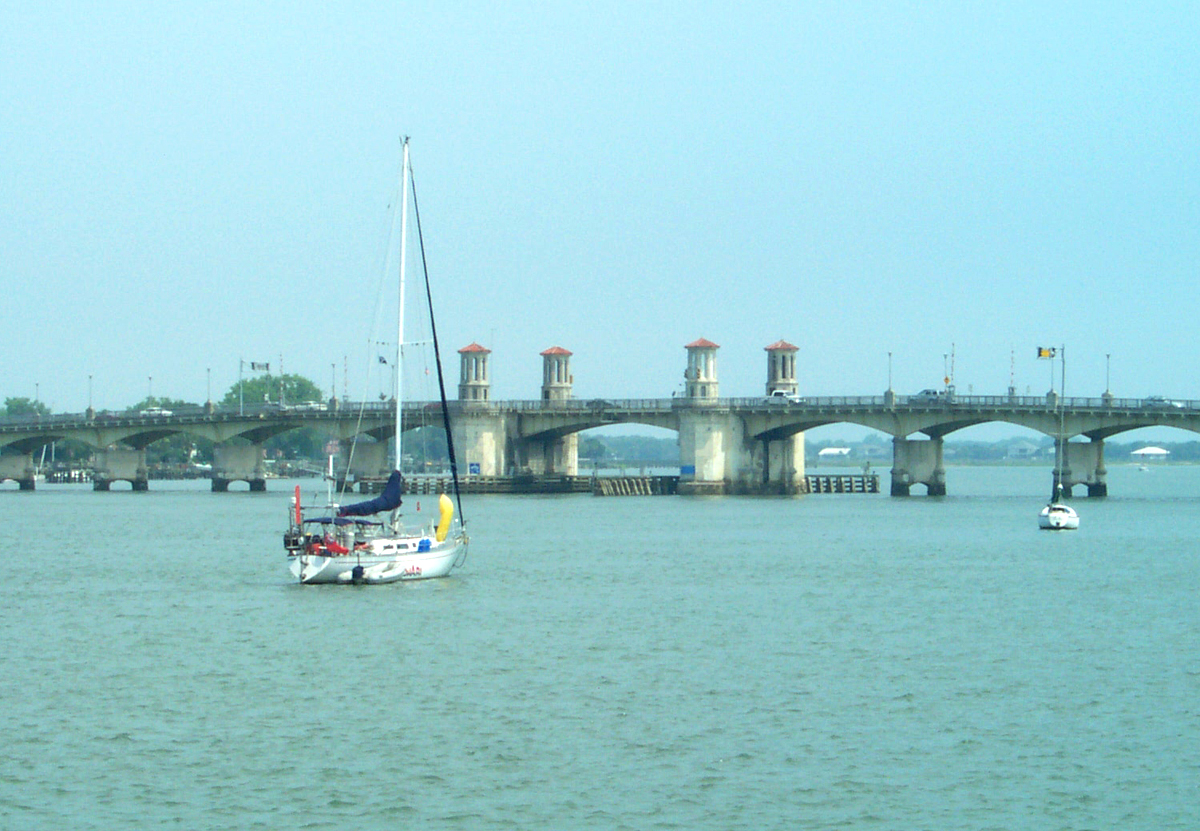
Bridge of Lions
Bridge · National Register of Historic Places · 2.6 mi
Bridge in Florida, United States of America

St. Augustine Light
Lighthouse · National Register of Historic Places · 3.2 mi
Lighthouse in Florida, United States

Museums and landmarks39

Abbott Tract Historic District
Monument and historic site · National Register of Historic Places · 2.2 mi
Historic district in St. Augustine, Florida

Dickinson Memorial Library and Park
Monument and historic site · National Register of Historic Places · 1.2 mi
Library in Orange City, Florida, United States

Fort Mose Historic State Park
Monument and historic site · National Register of Historic Places · 1.5 mi
Site of a former Spanish fort in St Augustine, Florida

Fullerwood Park Residential Historic District
Monument and historic site · National Register of Historic Places · 1.5 mi
Historic district in Florida, United States

González-Alvarez House
Museum · National Register of Historic Places · 3.0 mi
Historic home in St. Augustine, Florida

Government House
Monument and historic site · National Register of Historic Places · 2.7 mi
Old gubernatorial residence of Florida

Horace Walker House
Monument and historic site · National Register of Historic Places · 2.2 mi
Historic house in Florida, United States

Lightner Museum
Museum · National Register of Historic Places · 2.8 mi
Museum in St. Augustine, Florida

Lincolnville Historic District
Monument and historic site · National Register of Historic Places · 3.2 mi
Historic district in St. Augustine, Florida

Lindsley House
Monument and historic site · National Register of Historic Places · 2.8 mi
Listed on the National Register of Historic Places (NRHP) in St. Augustine, Florida, United States

Llambias House
Monument and historic site · National Register of Historic Places · 3.0 mi
Historic house in Florida, United States

Markland
Monument and historic site · National Register of Historic Places · 2.8 mi
Historic mansion in St. Augustine, Florida
27 more on the map.
Parks, trails and playgrounds12

Fountain of Youth Archaeological Park
Park · National Register of Historic Places · 1.8 mi
Private archaeological park

St. Augustine Alligator Farm Zoological Park
Park · National Register of Historic Places · 3.5 mi
American zoological park


Colonial Quarter
Park · 2.4 mi
Park in Florida, United States of America



Restaurants and cafes13

Aunt Kate's Restaurant
Restaurant · Regional · 1.5 mi
612 Euclid Avenue, Saint Augustine
Mo-Su 11:00-21:30

Address Coffee
Cafe · Coffee Shop · 1.5 mi
3676 Ponce de Leon Boulevard, Saint Augustine
Mo-Su 07:00-15:00
Bar Citra
Cafe · 1.5 mi
3676 North Ponce de Leon Boulevard, Saint Augustine
Th-Sa 07:30-20:30; Su-We 07:30-16:00
Schooner's Seafood House
Restaurant · Seafood · 1.5 mi
3560 Ponce de Leon Boulevard, Saint Augustine
Mo-Sa 11:00-21:00
DOS Coffee & Wine
Cafe · 1.5 mi
300 San Marco Avenue, Saint Augustine
Mo-Fr 07:00-19:00; Sa 07:00-17:00

Domino's
Fast food · Pizza · 1.6 mi
North Ponce De Leon Boulevard, Saint Augustine
Mo-Th 10:00-01:00; Fr-Sa 10:00-02:00; Su 10:00-01:00
Wendy's
Fast food · Burger · 1.6 mi
3531 North Ponce De Leon Boulevard, Saint Augustine
Mo-Tu 06:30-10:30; Th-Su 06:30-10:30
1 more on the map.
Where to stay9
Hampton Inn & Suites Saint Augustine-Vilano Beach
Motel and hotel · 1.1 mi
95 Vilano Road, Saint Augustine
Churches and places of worship6
Cathedral Basilica of St. Augustine
Church · National Register of Historic Places · 2.7 mi
Shopping3
Gas and EV charging1
Schools, colleges and libraries27
Map of Vilano Beach
113 places. The map loads OpenStreetMap tiles when you open it.
Climate by month
Monthly table
| Month | High | Low | Rain | Snow |
|---|---|---|---|---|
| Jan | 68°F | 48°F | 2.7 in | 0.0 in |
| Feb | 70°F | 50°F | 2.7 in | 0.0 in |
| Mar | 74°F | 55°F | 3.4 in | 0.0 in |
| Apr | 80°F | 61°F | 2.9 in | 0.0 in |
| May | 85°F | 67°F | 3.7 in | 0.0 in |
| Jun | 89°F | 72°F | 6.3 in | 0.0 in |
| Jul | 91°F | 74°F | 4.9 in | 0.0 in |
| Aug | 90°F | 74°F | 7.2 in | 0.0 in |
| Sep | 87°F | 73°F | 7.2 in | 0.0 in |
| Oct | 82°F | 66°F | 4.4 in | 0.0 in |
| Nov | 75°F | 58°F | 2.3 in | 0.0 in |
| Dec | 69°F | 51°F | 3.0 in | 0.0 in |
U.S. Climate Normals 1991-2020 for St Augustine Lighthouse (3 mi away), NOAA NCEI.
People and cost of living
American Community Survey 5-year estimates, 2020-2024, U.S. Census Bureau. Estimates have margins of error, larger for small towns.
Disaster history
St. Johns County has had 28 federal disaster declarations since 2000, most often for hurricanes.
- 2024-10-11: Hurricane Milton (Hurricane)
- 2024-10-07: Hurricane Milton (Hurricane)
- 2024-08-10: Hurricane Debby (Tropical Storm)
- 2024-08-03: Tropical Storm Debby (Tropical Storm)
- 2023-08-31: Hurricane Idalia (Hurricane)
- 2023-08-28: Tropical Storm Idalia (Tropical Storm)
OpenFEMA disaster declarations summaries.
Getting there and nearby towns
Northeast Florida Regional Airport (UST) is the nearest airport with scheduled flights listed in OpenStreetMap, 3 miles away.
- St. Augustine 2 mi south, about 4 min by car
- World Golf Village 12 mi west, about 19 min by car
- Nocatee 13 mi northwest, about 20 min by car
- Palm Valley 20 mi north, about 32 min by car
- Fruit Cove 22 mi northwest, about 36 min by car
- Green Cove Springs 23 mi west, about 37 min by car
- Jacksonville Beach 24 mi north, about 39 min by car
- Palm Coast 27 mi south, about 44 min by car
- Fleming Island 27 mi northwest, about 44 min by car
- Jacksonville 35 mi northwest, about 57 min by car
Drive times are estimates from straight-line distance, not routes.
Local news
Headlines from INDB, the NEMICO news database.
Reviews, tips and questions
Loading what members have shared...
Sources and licences
- NCES EDGE (Public domain): public schools
- NOAA NCEI U.S. Climate Normals 1991-2020 (Public domain): climate by month
- OpenFEMA (Public domain): disaster declarations
- OpenStreetMap contributors (ODbL 1.0): places, airports, map data
- U.S. Census Bureau (Public domain): population, income, housing, education, commute
- Wikidata (CC0 1.0): landmarks and historic places
- Wikimedia Commons (see each image): photos
- Wikipedia (CC BY-SA 4.0): overview and history text
Photo credits
- House in Vilano Beach, Florida, Flip Flops Hawaii, CC BY-SA 2.0
- Asphondylia ambrosiae gall (Vilano Beach, Florida), Pburka, CC BY-SA 4.0
- Beach sunflowers on the dunes at Vilano Beach, Florida (December 2025), Ben1152000, CC BY-SA 4.0
- St Aug North City HD01, Ebyabe, CC BY-SA 3.0
- St Aug Nelmar Terrace street01, Ebyabe, CC BY-SA 3.0
- St Aug Lindsley House01, Ebyabe, CC BY-SA 3.0
- St Aug Solla Carcoba01, Ebyabe, CC BY-SA 3.0
- Ximenez-Fatio House, St. Augustine, Kiran891, CC BY-SA 4.0
- St. Augustine Lighthouse Main View, Viktoriya Sorochuk, CC BY-SA 4.0
- St Aug Xavier Lopez House01, Ebyabe, CC BY-SA 3.0
- St Aug Abbott Tract HD house11b, Ebyabe, CC BY-SA 3.0
- St Aug FoY entr01, Ebyabe, CC BY-SA 3.0
- St Aug Sanchez Powder Site area01, Ebyabe, CC BY-SA 3.0
- St Aug O'Reilly House02, Ebyabe, CC BY-SA 3.0
- St Aug Lincolnville house04, Ebyabe, CC BY-SA 3.0
- St Aug Alligator Farm01, Ebyabe, CC BY-SA 3.0
- St Aug NHL Gonzalez-Alvarez01, Ebyabe, CC BY-SA 3.0
- StAugustineNatlCemetery, US gov, Public domain
- St Aug Mem Presby Church03, Ebyabe, CC BY-SA 3.0
- St Aug Fort Mose01, Ebyabe, CC BY-SA 3.0
- St Aug NHL Llambias01, Ebyabe, CC BY-SA 3.0
- BridgeLions StAugustineFL, Kristee M. Booth, Public domain
- Dickinson Memorial Library1, Ebyabe, CC BY 2.5
- St Aug Govt House Museum03, Ebyabe, CC BY-SA 3.0
- Facade of Cathedral of St. Augustine, Carlstak, CC BY-SA 4.0
- Lightner Museum inner courtyard, Kiran891, CC BY-SA 4.0
- St Aug Zorayda01, Ebyabe, CC BY-SA 3.0
- St Aug old county jail01, Ebyabe, CC BY-SA 3.0
- St Aug Stanbury Cottage01, Ebyabe, CC BY-SA 3.0
- St Aug Horace Walker01, Ebyabe, CC BY-SA 3.0
- Avero House plaque, St. Augustine, Kiran891, CC BY-SA 4.0
- St Aug Record Bldg01, Ebyabe, CC BY-SA 3.0
- St Aug Rod-Av-San01, Ebyabe, CC BY-SA 3.0
- St Aug Fullerwood Park06, Ebyabe, CC BY-SA 3.0
- St Aug Markland01, Ebyabe, CC BY-SA 3.0
- Saint Augustine,Florida,USA. - panoramio (25), Roman Eugeniusz, CC BY-SA 3.0
- Medieval Torture Museum, LittleT889, CC BY-SA 4.0
- Spanish Military Hospital Museum, St. Augustine 01, Kiran891, CC BY-SA 4.0
- Trinity Parish Episcopal Church, St. Augustine, Kiran891, CC BY-SA 4.0
- Colonial Quarter, St. Augustine, Florida, LittleT889, CC BY-SA 4.0


Page built October 30, 2026. Spotted a mistake? Tell us or suggest a place.