

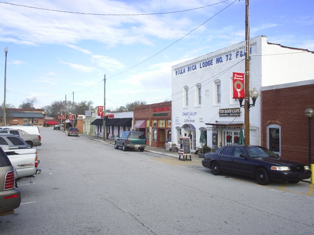
Villa Rica, Georgia
Villa Rica is a city of 18,551 people in Carroll County, Georgia, founded in 1826.
Why visit Villa Rica
Townapedia lists 7 museums and landmarks, 9 parks and trails, 55 places to eat, 6 places to stay and 2 attractions in and around town.
Highlights include Pine Mountain, Dorough Round Barn and Farm, North Villa Rica Commercial Historic District and Mirror Lake Golf Club.
July is the warmest month, with average highs of 90°F; January lows average 32°F.
Weather in Villa Rica
Forecast from the National Weather Service. Full forecast
About Villa Rica
Villa Rica (Spanish and Portuguese translation: Rich Village) is a city in Carroll and Douglas counties in the U.S. state of Georgia. Villa Rica is placed in the Atlanta metropolitan area. As of the 2020 census, Villa Rica had a population of 16,970.
From the Wikipedia article Villa Rica, Georgia (this version), under CC BY-SA 4.0.
Things to do2

Museums and landmarks7

Dorough Round Barn and Farm
Monument and historic site · National Register of Historic Places · 3.3 mi
Round barn in Carroll County, United States of America
North Villa Rica Commercial Historic District
Monument and historic site · National Register of Historic Places
Historic district in Villa Rica, Georgia, USA
Williams Family Farm
Monument and historic site · National Register of Historic Places · 2.1 mi
Parks, trails and playgrounds9





Restaurants and cafes55

Angles in the Kitchen
Diner · American · 1.4 mi
814 West Bankhead Highway, Villa Rica
Mo-Fr 06:00-18:00

Casa Sol Tex - Mex Grill & Bar
Restaurant · Mexican · 1.6 mi
955 W Hwy 78, Villa Rica
Mo-Th 11:00-21:00, Fr 11:00-22:00, Sa 12:00-22:00, Su 12:00-20:30
Evan's Barbeque Company
Restaurant · Barbecue · 0.4 mi
342 West Bankhead Highway, Villa Rica
Tu-Sa 11:00-21:00
Jefferson's
Diner · American · 1.3 mi
750 West Bankhead Highway, Villa Rica
Mo-We 10:30-22:00; Th-Sa 10:30-23:00; Su 10:30-22:00
La Chiquita Authentic Mexican Food
Restaurant · Mexican · 1.3 mi
901 South Carroll Road, Villa Rica
Tu-Sa 11:00-22:00; Su 11:30-21:00; Mo 11:00-22:00

Thai Basil Cuisine
Restaurant · Thai · 1.3 mi
921 South Carroll Road, Villa Rica
We-Fr 11:00-15:00,16:30-21:00; Sa-Su 12:00-21:00; Mo...
ATL WINGS N HIBACHI
Restaurant · 1.1 mi
606 Carrollton Villa Rica Highway, Villa Rica
Tu-Th 11:00-21:00; Fr-Sa 11:00-21:30; Su 12:00-19:00; Mo 11:00-21:00
Stix Bar & Grill
Restaurant · 1.0 mi
660 West Bankhead Highway, Villa Rica
Mo-Fr 11:30-02:00; Sa 12:00-02:00; Su 12:00-00:00
43 more on the map.
History
The location which was to become Villa Rica was originally settled in 1826 along what is now Dallas Highway. This land was ceded by the Creek people in 1825 with the second Treaty of Indian Springs signed by Chief William McIntosh. In 1826, farmers and gold miners arrived in the area from Pennsylvania, New Jersey and Delaware to what was then known as "Hixtown" (named after a local tavern operator, incorporated in 1830). One mile south was Chevestown, owned by Allison Cheeves. Hixtown and Cheevestown moved to Villa Rica's present location in 1882 when the railroad was built. Many of the original structures were physically moved to the new site (now known as the North Villa Rica Commercial Historic District) by rolling them on logs pulled by horses. The city was incorporated as Villa Rica in 1881. The name Villa Rica is derived from the Spanish for "rich village", and the city's name change was done to help promote the gold that had been found in the area.
From the History section of Villa Rica, Georgia on Wikipedia, under CC BY-SA 4.0.
Where to stay6
Churches and places of worship16
Kingdom Hall of Jehovah’s Witnesses
Place of worship · Jehovahs Witness · 2.3 mi
1535 Lake Paradise Road, Villa Rica
Shopping5
Gas and EV charging10
Schools, colleges and libraries15
Healthcare5
Map of Villa Rica
130 places. The map loads OpenStreetMap tiles when you open it.
Climate by month
Monthly table
| Month | High | Low | Rain | Snow |
|---|---|---|---|---|
| Jan | 54°F | 32°F | 5.0 in | 0.2 in |
| Feb | 58°F | 34°F | 5.3 in | 0.0 in |
| Mar | 66°F | 40°F | 5.6 in | 0.0 in |
| Apr | 74°F | 48°F | 4.6 in | 0.0 in |
| May | 81°F | 57°F | 3.8 in | 0.0 in |
| Jun | 87°F | 65°F | 4.1 in | 0.0 in |
| Jul | 90°F | 69°F | 4.5 in | 0.0 in |
| Aug | 88°F | 68°F | 3.7 in | 0.0 in |
| Sep | 83°F | 62°F | 3.8 in | 0.0 in |
| Oct | 74°F | 50°F | 3.7 in | 0.0 in |
| Nov | 64°F | 39°F | 4.4 in | 0.0 in |
| Dec | 56°F | 34°F | 5.1 in | 0.4 in |
U.S. Climate Normals 1991-2020 for Carrollton (13 mi away), NOAA NCEI.
People and cost of living
American Community Survey 5-year estimates, 2020-2024, U.S. Census Bureau. Estimates have margins of error, larger for small towns.
Disaster history
Carroll County has had 16 federal disaster declarations since 2000, most often for hurricanes.
- 2026-10-09: Hurricane Isaias (Tropical Storm)
- 2026-01-24: Severe Winter Storm (Winter Storm)
- 2024-09-26: Hurricane Helene (Tropical Storm)
- 2021-01-12: Tropical Storm Zeta (Hurricane)
- 2020-03-29: Covid-19 Pandemic (Biological)
- 2020-03-13: Covid-19 (Biological)
OpenFEMA disaster declarations summaries.
Getting there and nearby towns
Fulton County Airport-Brown Field (FTY) is the nearest airport with scheduled flights listed in OpenStreetMap, 23 miles away.
- Douglasville 13 mi east, about 20 min by car
- Carrollton 14 mi southwest, about 22 min by car
- Dallas 14 mi north, about 22 min by car
- Lithia Springs 16 mi east, about 26 min by car
- Powder Springs 17 mi northeast, about 27 min by car
- South Fulton 20 mi east, about 33 min by car
- Mableton 21 mi east, about 33 min by car
- Union City 23 mi southeast, about 36 min by car
- Fairburn 23 mi southeast, about 37 min by car
- Smyrna 25 mi east, about 40 min by car
Drive times are estimates from straight-line distance, not routes.
Local news
Headlines from INDB, the NEMICO news database.
Reviews, tips and questions
Loading what members have shared...
Sources and licences
- NCES EDGE (Public domain): public schools
- NOAA NCEI U.S. Climate Normals 1991-2020 (Public domain): climate by month
- OpenFEMA (Public domain): disaster declarations
- OpenStreetMap contributors (ODbL 1.0): places, airports, map data
- U.S. Census Bureau (Public domain): population, income, housing, education, commute
- Wikidata (CC0 1.0): elevation, founding date, time zone, website, landmarks and historic places
- Wikimedia Commons (see each image): photos
- Wikipedia (CC BY-SA 4.0): overview and history text
Photo credits
- Berrys Pharmacy, Villa Rica GA, John Phelan, CC BY 4.0
- NorthVillaRicaCommercialHistoricDistrict, Optimistmb, CC BY-SA 4.0
Page built October 30, 2026. Spotted a mistake? Tell us or suggest a place.