



Warr Acres, Oklahoma
Warr Acres is a city of 10,466 people in Oklahoma County, Oklahoma.
Why visit Warr Acres
Townapedia lists 4 museums and landmarks, 17 parks and trails, 55 places to eat, 6 places to stay and 2 attractions in and around town.
Highlights include Southern Nazarene University, Wedgewood Village Amusement Park, Donald Pollock House and Founders Tower.
July is the warmest month, with average highs of 95°F; January lows average 28°F.
Weather in Warr Acres
Forecast from the National Weather Service. Full forecast
About Warr Acres
Warr Acres is a city in Oklahoma County, Oklahoma, United States, and a part of the Oklahoma City metropolitan area. It was established after World War II by C.B. Warr, a dynamic businessman, builder, and commercial developer. The population was 10,452 at the 2020 census, a 4.1% increase from 2010.
From the Wikipedia article Warr Acres, Oklahoma (this version), under CC BY-SA 4.0.
Things to do2

Southern Nazarene University
School · 1.1 mi
Christian liberal arts college located in Bethany, Oklahoma, United States

Wedgewood Village Amusement Park
Monument and historic site · 1.7 mi
Former amusement park in Oklahoma City, Oklahoma, United States
Museums and landmarks4

Donald Pollock House
Monument and historic site · National Register of Historic Places · 3.7 mi
Historic house in Oklahoma, United States
Founders Tower
Monument and historic site · National Register of Historic Places · 2.6 mi
Residential in Oklahoma City, Oklahoma
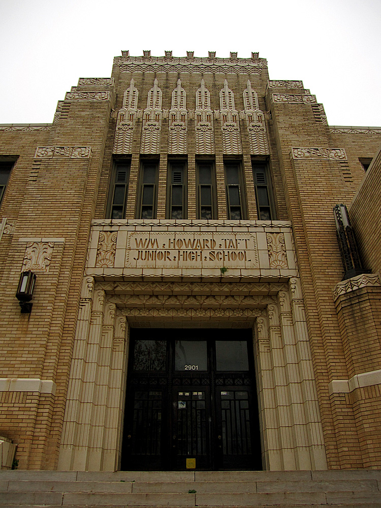
Taft Middle School
Monument and historic site · National Register of Historic Places · 3.7 mi
Historic school building in Oklahoma City, Oklahoma, United States


Will Rogers Gardens
Monument and historic site · National Register of Historic Places · 2.6 mi
Oklahoma City, Oklahoma
Parks, trails and playgrounds17


Elden Lyon Park
Park · 1.8 mi
Large city-operated park in Oklahoma, USA
5 more on the map.
Restaurants and cafes55

Hideaway Pizza
Restaurant · Bavarian, Pizza, Burger · 1.5 mi
5501 Northwest Expressway, Warr Acres
Su-Th 11:00-21:30; Fr-Sa 11:00-22:30

Starbucks
Cafe · Coffee Shop · 1.6 mi
5836 Northwest Expressway, Warr Acres
Mo-Th 05:30-21:00; Fr 05:30-23:00; Sa 06:00-23:00; Su 06:00-20:30
Cajun King Restaurant and Bar
Restaurant · Seafood · 0.7 mi
5816 Northwest 63rd Street, Warr Acres
Mo-Sa 11:00-21:00, Su 11:00-16:00
Lemongrass Hotpot
Restaurant · Asian · 1.4 mi
4801 Northwest Expressway, Oklahoma City
Mo-Th 12:00-22:00; Fr, Sa 12:00-22:30; Su 12:00-21:30
Abel's
Restaurant · Mexican
5822 Northwest 50th Street, Warr Acres
Mo-Su 11:00-11:00
Eggceptional Cafe
Restaurant · Breakfast · 1.8 mi
Mo-Fr 07:00-14:00; Sa-Su 07:00-15:00

Moe's Place
Diner · American
5012 North MacArthur Boulevard, Warr Acres
Mo-Sa 06:30-14:00, Su 08:00-14:00
Banana Thai Kitchen
Restaurant · Thai · 1.9 mi
6220 Northwest Expressway, Oklahoma City
43 more on the map.
History
The Warr Acres housing addition and Warr Acres Second Addition was developed in 1937 by Clyde B. Warr. An addition that would later form part of the city of Warr Acres, Putnam City was developed by state lawmaker Israel Putnam in 1909.
The city formed when the residents of 11 additions, including Putnam City, petitioned to incorporate in February 1948. The city of Bethany filed suit, but lost in an Oklahoma Supreme Court decision.
As was common in early statehood, Warr Acres was one of several racially segregated communities that used restrictive covenants and extra-legal means to prevent African-Americans from owning properties from its founding through the 1960s.. Warr Acres is currently a racially diverse city.
According to the 2020 U.S. census, the racial composition of Warr Acres was as follows:
Shopping districts appeared along MacArthur Avenue in the 1960s and 1970s. By 1979, the town had grown to almost three-square miles after annexing several residential developments. with shopping districts along MacArthur Blvd and Northwest Expressway, as well as Route 66 (39th Street).
From the History section of Warr Acres, Oklahoma on Wikipedia, under CC BY-SA 4.0.
Where to stay6
Extended Stay America - Oklahoma City - Northwest
Motel and hotel · 1.4 mi
4811 Northwest Expressway, Oklahoma City
La Quinta Inn & Suites Oklahoma City - NW Expwy
Motel and hotel · 1.5 mi
4829 Northwest Expressway, Oklahoma City
Churches and places of worship40
Saint Charles Borromeo Catholic Church
Church · Roman Catholic · 0.4 mi
5024 North Grove Avenue, Oklahoma City
Kingdom Hall of Jehovahs Witnesses Oakglen
Church · Jehovahs Witness · 1.2 mi
5749 Northwest 37th Street, Oklahoma City
Lifeline Alliance Church
Church · 1.3 mi
4231 Northwest 50th Street, Oklahoma City
Saint David's Episcopal Church
Church · Episcopal · 1.7 mi
3333 North Meridian Avenue, Oklahoma City
Christ Community Fellowship Church
Church · 1.5 mi
7200 Lyrewood Lane, Oklahoma City
Church of Jesus Christ of Latter-Day Saints
Church · 0.7 mi
5020 Northwest 63rd Street
Shopping8
Gas and EV charging6
Schools, colleges and libraries50
Healthcare2
The Children’s Center Rehabilitation Hospital
Hospital · 1.4 mi
6800 Northwest 39th Expressway, Bethany
Map of Warr Acres
190 places. The map loads OpenStreetMap tiles when you open it.
Climate by month
Monthly table
| Month | High | Low | Rain |
|---|---|---|---|
| Jan | 50°F | 28°F | 0.8 in |
| Feb | 55°F | 31°F | 1.0 in |
| Mar | 64°F | 40°F | 2.0 in |
| Apr | 72°F | 49°F | 3.0 in |
| May | 80°F | 59°F | 4.3 in |
| Jun | 89°F | 68°F | 4.8 in |
| Jul | 95°F | 73°F | 2.9 in |
| Aug | 94°F | 71°F | 3.5 in |
| Sep | 85°F | 63°F | 3.0 in |
| Oct | 74°F | 51°F | 2.7 in |
| Nov | 62°F | 39°F | 1.5 in |
| Dec | 51°F | 30°F | 1.3 in |
U.S. Climate Normals 1991-2020 for Oklahoma City Post Ap (2 mi away), NOAA NCEI.
People and cost of living
American Community Survey 5-year estimates, 2020-2024, U.S. Census Bureau. Estimates have margins of error, larger for small towns.
Disaster history
Oklahoma County has had 43 federal disaster declarations since 2000, most often for fires.
- 2026-08-13: Train Trestle Fire (Fire)
- 2025-05-21: Wildfires And Straight-Line Winds (Fire)
- 2025-03-18: Severe Storms, Straight-Line Winds, Tornadoes, And Flooding (Severe Storm)
- 2025-03-14: Luther Fire (Fire)
- 2023-03-31: Hefner Fire, Oklahoma Fmag (Fire)
- 2021-02-24: Severe Winter Storms (Severe Ice Storm)
OpenFEMA disaster declarations summaries.
Getting there and nearby towns
Wiley Post Airport (PWA) is the nearest airport with scheduled flights listed in OpenStreetMap, 2 miles away.
- Bethany 2 mi southwest, about 3 min by car
- Oklahoma City 7 mi southeast, about 12 min by car
- Yukon 8 mi west, about 13 min by car
- Mustang 11 mi southwest, about 18 min by car
- Del City 11 mi southeast, about 18 min by car
- Midwest City 14 mi east, about 23 min by car
- Edmond 15 mi northeast, about 25 min by car
- Moore 16 mi southeast, about 26 min by car
- El Reno 18 mi west, about 30 min by car
- Newcastle 20 mi south, about 32 min by car
Drive times are estimates from straight-line distance, not routes.
Local news
Headlines from INDB, the NEMICO news database.
Reviews, tips and questions
Loading what members have shared...
Sources and licences
- NCES EDGE (Public domain): public schools
- NOAA NCEI U.S. Climate Normals 1991-2020 (Public domain): climate by month
- OpenFEMA (Public domain): disaster declarations
- OpenStreetMap contributors (ODbL 1.0): places, airports, map data
- U.S. Census Bureau (Public domain): population, income, housing, education, commute
- Wikidata (CC0 1.0): elevation, founding date, time zone, website, landmarks and historic places
- Wikimedia Commons (see each image): photos
- Wikipedia (CC BY-SA 4.0): overview and history text
Photo credits
- WAFD Engine 23, Orca1 9904, CC BY-SA 4.0
- DonaldPollockHouseOKC, Melodibit, CC BY-SA 3.0
- Oklahoma City, OK - USA - Will Rogers Park - panoramio (8), MARELBU, CC BY 3.0
- Taft Junior High School, H.L.I.T., CC BY 2.0
- Unitedfounders 10 29 07 c, Doug Loudenback, http://www.dougloudenback.com/ http://s8.photobucket.com/albums/a49/DougLoudenback/ http://www.dougdawg.blogspot.com/, CC BY-SA 3.0
Page built October 30, 2026. Spotted a mistake? Tell us or suggest a place.