
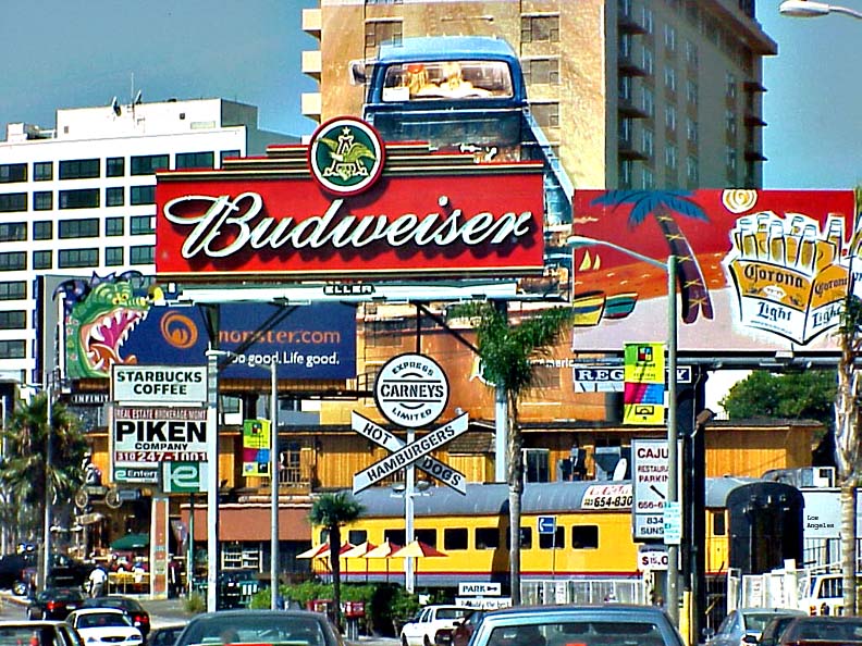


West Hollywood, California
West Hollywood is a city of 34,884 people in Los Angeles County, California, founded in November 28, 1984.
Why visit West Hollywood
Townapedia lists 92 museums and landmarks, 20 parks and trails, 369 places to eat, 30 places to stay and 19 attractions in and around town.
Highlights include DGA Theater Complex, The Comedy Store, Schindler House and Aloha Apartment Hotel.
August is the warmest month, with average highs of 79°F; February lows average 51°F.
Weather in West Hollywood
Forecast from the National Weather Service. Full forecast
About West Hollywood
West Hollywood is a city in Los Angeles County, California, United States. Incorporated in 1984, it is home to the Sunset Strip, and located between the cities of Los Angeles and Beverly Hills. As of the 2020 U.S. census, its population was 35,757. Despite its name, West Hollywood has never been part of Hollywood or the City of Los Angeles.
From the Wikipedia article West Hollywood, California (this version), under CC BY-SA 4.0.
Things to do19

Beverly Hills Playhouse
Cinema and theater · 1.4 mi
Acting school with theaters and training facilities in Beverly Hills, California, and other U. S. cities
Dolby Theatre
Cinema and theater · 2.1 mi
Live entertainment theatre in Los Angeles, California, United States
Hollywood Bowl
Cinema and theater · 2.5 mi
Open-air theatre in Hollywood, Los Angeles, California, USA
Hollywood Pantages Theatre
Cinema and theater · 2.8 mi
Theater and movie theater in Hollywood, Los Angeles, California
Shubert Theatre
Cinema and theater · 3.2 mi
Former theater in Century City, Los Angeles, California, United States
Landmark Theatres Sunset
Cinema and theater · 0.7 mi
8000 West Sunset Boulevard, Los Angeles
7 more on the map.
Museums and landmarks92
Schindler House
Monument and historic site · National Register of Historic Places
House in West Hollywood, California, designed by architect Rudolf Schindler

Aloha Apartment Hotel
Monument and historic site · National Register of Historic Places · 2.0 mi
Historic building in Los Angeles, California, United States

Anderton Court Shops
Monument and historic site · National Register of Historic Places · 2.2 mi
Shopping center in Beverly Hills, California

Bailey House
Monument and historic site · National Register of Historic Places · 2.3 mi
House

Beverly Fairfax Historic District
Monument and historic site · National Register of Historic Places · 1.1 mi
Neighborhood in Los Angeles, California, United States
Beverly Hills Main Post Office
Monument and historic site · National Register of Historic Places · 1.3 mi
Post office in Beverly Hills, United States of America

Beverly Hills Women's Club
Monument and historic site · National Register of Historic Places · 2.9 mi
Clubhouse in Beverly Hills, United States of America

Beverly Wilshire Hotel
Monument and historic site · National Register of Historic Places · 2.2 mi
Hotel in Beverly Hills, California, United States

C.E. Toberman Estate
Monument and historic site · National Register of Historic Places · 1.7 mi
Historic house in California, United States

Capitol Records Building
Monument and historic site · National Register of Historic Places · 2.8 mi
Hollywood Boulevard Commercial and Entertainment District building

Chateau Colline
Monument and historic site · National Register of Historic Places · 3.5 mi
Building in California, United States


Colonial House
Monument and historic site · National Register of Historic Places · 0.6 mi
Seven-story building in West Hollywood, California
80 more on the map.
Parks, trails and playgrounds20

Will Rogers Memorial Park
Park · 2.4 mi
Public park in Beverly Hills, California
William S. Hart Park
Park · 0.5 mi
8341 De Longpre Avenue, West Hollywood
8 more on the map.
Restaurants and cafes369

Carney's Restaurant
Restaurant · Burger, Hot Dog · 0.5 mi
8351 West Sunset Boulevard, West Hollywood
Su-Th 11:00-00:00, Fr-Sa 11:00-03:00
Crossroads Kitchen
Restaurant · Mediterranean
8284 Melrose Avenue
Mo-Fr 11:00-15:00, 17:00-22:00; Sa-Su 10:00-15:00, 17:00-22:00

Rainbow Bar & Grill
Bar and pub · 1.0 mi
9015 West Sunset Boulevard, West Hollywood
Mo-Fr 11:00-02:00, Sa-Su 17:00-02:00

Starbucks
Cafe · Coffee Shop · 0.9 mi
8969 North Robertson Boulevard, West Hollywood
Mo-Su 06:00-21:00
The Coffee Bean & Tea Leaf
Cafe · Coffee Shop · 0.6 mi
8735 Santa Monica Boulevard, West Hollywood
Mo-Th 06:00-21:00; Fr-Sa 06:00-22:00; Su 19:00-22:00
Amarone Kitchen & Wine
Restaurant · Italian · 0.8 mi
8868 West Sunset Boulevard, West Hollywood
Mo-Su 17:30-22:00
Aroma
Restaurant · American, Turkish, Grill, Breakfast, Kebab, Seafood, Pasta, Pizza, Beef Bowl, Fine Dining, Fish, Sandwich, International, Burger, Barbecue, Mediterranean · 1.4 mi
7373 West Sunset Boulevard
Mo-Fr 11:30-02:00; Sa-Su 09:00-04:00
Bar Next Door
Bar and pub · 1.1 mi
Intimate craft cocktail bar, renowned for its expertly crafted classic and artisanal cocktails in a vintage, Hollywood-inspired setting....
9159 West Sunset Boulevard, West Hollywood
Mo-Th 18:00-01:00; Fr-Sa 17:00-02:00; Su off
Boa Steakhouse
Restaurant · Steak House · 1.2 mi
9200 West Sunset Boulevard, West Hollywood
Mo-Th 12:00-14:00, 17:30-22:30; Fr 12:00-14:00, 17:30-00:00, Sa...
Bossa Nova
Restaurant · Brazilian · 0.9 mi
685 North Robertson Boulevard, West Hollywood
Mo-Th 11:00-23:30; Fr,Sa 11:00-03:30, Su 11:00-00:00
Burger Lounge
Restaurant · Burger · 0.5 mi
8539 West Sunset Boulevard, West Hollywood
Su-Th 11:00-21:30; Fr-Sa 11:00-22:00
357 more on the map.
History
The land that is now West Hollywood lies within the traditional territory of the Tongva, who inhabited the Los Angeles Basin for centuries before European contact. Spanish colonization of Alta California began in the late eighteenth century; the Portolá expedition of 1769–1770, an overland Spanish reconnaissance from San Diego to Monterey led by Gaspar de Portolá, passed through the Los Angeles Basin in August 1769. Near what would later become West Hollywood, the party collected pitch (Spanish brea) from natural tar seeps, which they used to waterproof gear. The Spanish mission system that followed reclassified the Tongva as "Gabrielinos" after the Mission San Gabriel Arcángel, and by 1771 introduced European diseases had severely reduced the indigenous population. Here they collected pitch (brea in Spanish) from tar pits which they used to waterproof their belongings and to say Mass. The Gabrielinos are believed to have burned the pitch for fuel.
By 1780, what became the "Sunset Strip" was the major connecting road for El Pueblo de Los Angeles, and all ranches westward to the Pacific Ocean. This land passed through the hands of various owners during the next one hundred years, and it was called names such as "La Brea" and "Plummer" that are listed in historical records. Most of this area was part of the Rancho La Brea, and eventually it came to be owned by the Hancock family.
From the History section of West Hollywood, California on Wikipedia, under CC BY-SA 4.0.
Where to stay30
Best Western Plus Sunset Plaza Hotel
Motel and hotel · 0.5 mi
8400 West Sunset Boulevard, West Hollywood
Ramada Plaza West Hollywood Hotel & Suites
Motel and hotel · 0.4 mi
8585 Santa Monica Boulevard, West Hollywood
Churches and places of worship26
Church of the Good Shepherd (Beverly Hills, California)
Church · 2.4 mi
Nichiren Shoshu Myohoji Temple
Place of worship · Nichiren Shoshu · 0.6 mi
1401 North Crescent Heights Boulevard, West Hollywood
Etz Jacob Synagogue
Place of worship · 1.2 mi
7659 Beverly Boulevard, Los Angeles
Shopping59
Gas and EV charging11
Schools, colleges and libraries54
Citizens of The World Charter School East Valley
School · 5.9 mi
12020 Burbank Blvd., Valley Village
Healthcare17
Brentview Medical Urgent Care
Clinic and pharmacy
8264 Santa Monica Boulevard, West Hollywood
Map of West Hollywood
250 places. The map loads OpenStreetMap tiles when you open it.
Climate by month
Monthly table
| Month | High | Low | Rain | Snow |
|---|---|---|---|---|
| Jan | 68°F | 52°F | 4.1 in | 0.0 in |
| Feb | 67°F | 51°F | 4.7 in | 0.0 in |
| Mar | 68°F | 52°F | 2.7 in | 0.0 in |
| Apr | 70°F | 54°F | 0.8 in | 0.0 in |
| May | 70°F | 56°F | 0.4 in | 0.0 in |
| Jun | 73°F | 59°F | 0.1 in | 0.0 in |
| Jul | 77°F | 62°F | 0.0 in | 0.0 in |
| Aug | 79°F | 63°F | 0.0 in | 0.0 in |
| Sep | 79°F | 62°F | 0.1 in | 0.0 in |
| Oct | 76°F | 60°F | 0.7 in | 0.0 in |
| Nov | 72°F | 55°F | 1.0 in | 0.0 in |
| Dec | 67°F | 51°F | 2.9 in | 0.0 in |
U.S. Climate Normals 1991-2020 for U C L A (4 mi away), NOAA NCEI.
People and cost of living
American Community Survey 5-year estimates, 2020-2024, U.S. Census Bureau. Estimates have margins of error, larger for small towns.
Disaster history
Los Angeles County has had 67 federal disaster declarations since 2000, most often for fires.
- 2025-08-08: Canyon Fire (Fire)
- 2025-01-08: Wildfires And Straight-Line Winds (Fire)
- 2025-01-08: Eaton Fire (Fire)
- 2025-01-08: Hurst Fire (Fire)
- 2025-01-07: Palisades Fire (Fire)
- 2024-12-10: Franklin Fire (Fire)
OpenFEMA disaster declarations summaries.
Getting there and nearby towns
Santa Monica Municipal Airport (SMO) is the nearest airport with scheduled flights listed in OpenStreetMap, 7 miles away.
- Beverly Hills 2 mi west, about 3 min by car
- Los Angeles 5 mi southwest, about 8 min by car
- Culver City 6 mi south, about 9 min by car
- Burbank 7 mi north, about 12 min by car
- View Park-Windsor Hills 7 mi south, about 11 min by car
- Santa Monica 9 mi southwest, about 14 min by car
- Inglewood 9 mi south, about 15 min by car
- Glendale 10 mi northeast, about 16 min by car
- Lennox 10 mi south, about 17 min by car
- Florence-Graham 11 mi southeast, about 18 min by car
Drive times are estimates from straight-line distance, not routes.
Local news
Headlines from INDB, the NEMICO news database.
Reviews, tips and questions
Loading what members have shared...
Sources and licences
- NCES EDGE (Public domain): public schools
- NOAA NCEI U.S. Climate Normals 1991-2020 (Public domain): climate by month
- OpenFEMA (Public domain): disaster declarations
- OpenStreetMap contributors (ODbL 1.0): places, airports, map data
- U.S. Census Bureau (Public domain): population, income, housing, education, commute
- Wikidata (CC0 1.0): elevation, founding date, time zone, website, landmarks and historic places
- Wikimedia Commons (see each image): photos
- Wikipedia (CC BY-SA 4.0): overview and history text
Photo credits
- Sunsetblvd, Jeff Costlow, Public domain
- Schindler House isometry, Stanley A. Westfall, Jeffrey B. Lentz, Public domain
- Montecito Apartments, Hollywood, California, Los Angeles, CC BY-SA 3.0
- Hollywood Studio Club, North Wing, Los Angeles, CC BY-SA 3.0
- La Belle Tour (Hollywood Tower), Hollywood, California, Los Angeles, CC BY-SA 3.0
- Highsmithargylehotelsunsetstrip, Carol M. Highsmith, Public domain
- Samuel Freeman House, Hollywood, California, Los Angeles, CC BY-SA 3.0
- Capitol Records sunset, Downtowngal, CC BY-SA 3.0
- Beverly Fairfax. 2022-03-04 12-08-15, Shesmax, CC BY-SA 4.0
- Security Trust and Savings, Hollywood, California, Los Angeles, CC BY-SA 3.0
- Virginia Robinson Estate, Los Angeles, CC BY-SA 3.0
- John C. Fremont Branch Library, Los Angeles, California, Los Angeles, CC BY-SA 3.0
- Hollywood Melrose Hotel (Monte Cristo Island Apartments), Los Angeles, CC BY-SA 3.0
- BeverlyWilshire01, Minnaert, Public domain
- El Greco Apartments, Los Angeles, Los Angeles, CC BY-SA 3.0
- Aloha Apartment Hotel, Harasdee, CC BY-SA 4.0
- Hollywood Masonic Temple, Los Angeles, CC BY-SA 3.0
- Colonial House, West Hollywood, Los Angeles, CC BY-SA 3.0
- Halifax Apartments Hollywood from northwest 2015-11-15, Junkyardsparkle, CC0
- Patio Del Moro, West Hollywood, Los Angeles, CC BY-SA 3.0
- Storer House, Hollywood Boulevard, Los Angeles, CC BY-SA 3.0
- Case Study 21, Ilpo's Sojourn, CC BY 2.0
- U.S. Post Office Hollywood, Mollylou12 ( talk ) Courtesy (c) 2008 by Molly Berke, CC BY 3.0
- Pan Pacfic Auditorium, Pavel Dvorak, CC0
- Petitfils-Boos House, Hancock Park, Los Angeles, CC BY-SA 3.0
- Greystone Mansion, Los Angeles, CC BY-SA 3.0
- Beverly Hills Womens Club, Los Angeles, CC BY-SA 3.0
- Harold Lloyd Estate (Beverly Hills, CA), Jack Boucher, Public domain
- Memorial Branch Library, Los Angeles, Los Angeles, CC BY-SA 3.0
- Hollywood Palladium 2012, Doug Goodwin, CC BY-SA 3.0
- Chateau Colline, Los Angeles, Los Angeles, CC BY-SA 3.0
- Charles Toberman Estate, Hollywood, Los Angeles, CC BY-SA 3.0
- CommunityClub, Floatjon, CC BY-SA 3.0
- HollywoodHighSchool, Galen Smith from Minneapolis, MN, USA, CC BY-SA 2.0
- Andalusia, Havenhurst Dr., Los Angeles, Los Angeles, CC BY-SA 3.0
- 2009-0727-CA-Paramount-HollywoodForever, Bobak Ha'Eri, CC BY 3.0
- Yamashiro Restaurant Hollywood 2019 by Glenn Francis, Toglenn, CC BY-SA 4.0
- HollywoodHeritageMuseum01, Minnaert, Public domain
- Guaranty Building, Hollywood, California, Los Angeles, CC BY-SA 3.0
- Womens Club of Hollywood, Downtowngal, CC BY-SA 4.0


Page built October 30, 2026. Spotted a mistake? Tell us or suggest a place.