


Why visit West Wendover
Townapedia lists 8 museums and landmarks, 5 parks and trails, 15 places to eat, 10 places to stay and 4 attractions in and around town.
Highlights include Wendover Cinemas, Peppermill Concert Hall, Danger Cave and Wendover Air Force Base.
July is the warmest month, with average highs of 92°F; January lows average 20°F.
Weather in West Wendover
Forecast from the National Weather Service. Full forecast
About West Wendover
West Wendover is a city in Elko County, Nevada, United States. The population was 4,512 at the 2020 census. It is part of the Elko micropolitan area. West Wendover is located on the eastern border of Nevada and the western edge of the Great Salt Lake Desert and is contiguous with Wendover, Utah, with which it is sometimes confused.
From the Wikipedia article West Wendover, Nevada (this version), under CC BY-SA 4.0.
Things to do4


Museums and landmarks8

Danger Cave
Monument and historic site · National Register of Historic Places · 3.4 mi
Archaeological site in Tooele County, Utah, United States
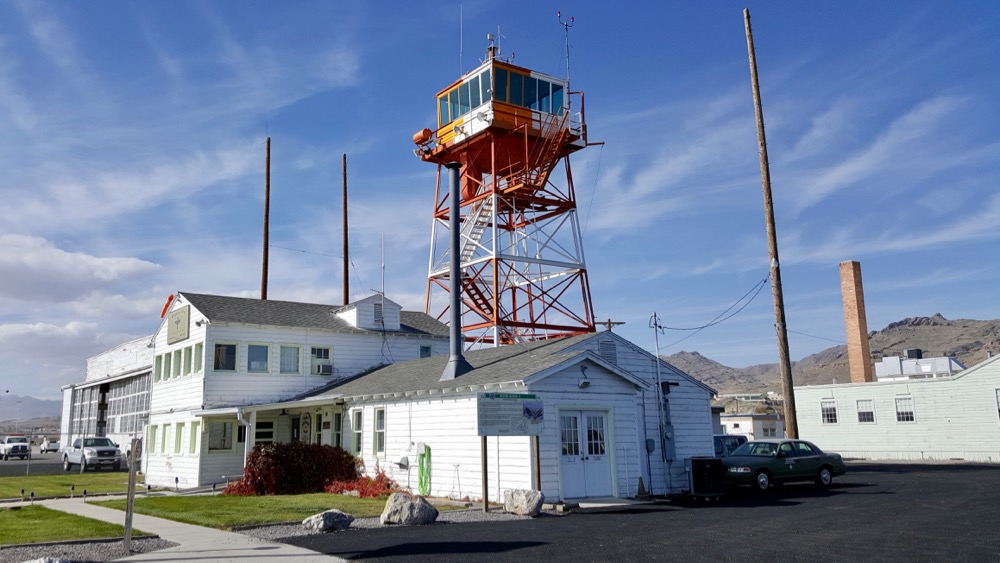
Wendover Air Force Base
Monument and historic site · National Register of Historic Places · 2.9 mi
Former United States Air Force base in Utah now known as Wendover Airport

Historic Wendover Airfield
Museum · 2.5 mi
352 East Airport Way, Wendover
Tu-Fr 10:00-16:00; Sa 11:00-17:00

C-123 Provider
Monument and historic site · 2.4 mi
C-123 used for taxi scenes in the Movie "Con Air"
Parks, trails and playgrounds5





Restaurants and cafes15

Salt Flats Cafe
Restaurant · Mexican, American · 2.1 mi
85 East Skyhawk Drive, Wendover
Mo-Su 10:00-20:30
Robeerto's Mexican Food
Restaurant · Mexican · 1.9 mi
42 E Wendover Boulevard, Wendover
24/7

Copper Kettle Cafe
Restaurant · American, Mexican · 2.3 mi
600 East Wendover Boulevard, Wendover


Subway
Fast food · Sandwich · 1.9 mi
Located inside Miller's Travel Centers convenience store.
80 E Wendover Boulevard, Wendover
Arby's
Fast food · Sandwich · 0.7 mi
Located inside Pilot Travel Center.
1200 Wendover Boulevard, West Wendover
Mo-Su 07:00-24:00
3 more on the map.
History
West Wendover began to develop in the 1930s and 1940s with the introduction of legalized gambling in the state of Nevada. William "Bill" Smith founded a small cobblestone service station for travelers crossing the desert terrain of western Utah and eastern Nevada. Today this facility is known as the Wendover Nugget. It held the record as the oldest continually operated gaming license for a casino in the state of Nevada for over 66 years, until December 2001, when the former State Line Casino and Hotel came under new ownership.
Through the 1970s and 1980s, West Wendover began to emerge as a destination resort. Additional business arrived constructing more casinos, hotels and other service establishments, as well as recreational venues, such as the Toana Vista Golf Course. As growth continued to spiral up, the citizens of West Wendover, Nevada, then a township of Elko County, elected to incorporate under self-rule. On July 1, 1991, the city of West Wendover, Nevada came into existence. Amber S Holt named the city seal of West Wendover encouraging people to "Come Grow With Us."
From the History section of West Wendover, Nevada on Wikipedia, under CC BY-SA 4.0.
Where to stay10
Peppermill Hotel Casino : Wendover
Motel and hotel · 1.2 mi
680 Wendover Boulevard, West Wendover
Western Ridge Motel
Motel and hotel · 2.5 mi
895 East Wendover Boulevard, Wendover
Churches and places of worship2
Shopping3
Gas and EV charging11
Carrillo Brothers Auto Service
Gas station · 2.2 mi
601 East Wendover Boulevard, Wendover
Schools, colleges and libraries10
Map of West Wendover
68 places. The map loads OpenStreetMap tiles when you open it.
Climate by month
Monthly table
| Month | High | Low | Rain |
|---|---|---|---|
| Jan | 35°F | 20°F | 0.2 in |
| Feb | 42°F | 25°F | 0.2 in |
| Mar | 54°F | 33°F | 0.3 in |
| Apr | 62°F | 40°F | 0.4 in |
| May | 72°F | 50°F | 0.6 in |
| Jun | 83°F | 59°F | 0.3 in |
| Jul | 92°F | 67°F | 0.2 in |
| Aug | 90°F | 65°F | 0.2 in |
| Sep | 78°F | 54°F | 0.5 in |
| Oct | 62°F | 41°F | 0.3 in |
| Nov | 46°F | 28°F | 0.2 in |
| Dec | 36°F | 20°F | 0.2 in |
U.S. Climate Normals 1991-2020 for Wendover Ap Awos Hcn 72581 (3 mi away), NOAA NCEI.
People and cost of living
American Community Survey 5-year estimates, 2020-2024, U.S. Census Bureau. Estimates have margins of error, larger for small towns.
Disaster history
Elko County has had 18 federal disaster declarations since 2000, most often for fires.
- 2020-04-04: Covid-19 Pandemic (Biological)
- 2020-03-13: Covid-19 (Biological)
- 2017-07-17: Oil Well Fire (Fire)
- 2017-03-27: Severe Winter Storms, Flooding, And Mudslides (Severe Storm)
- 2011-10-03: Indian Creek Fire (Fire)
- 2007-07-23: Murphy Fire Complex (Fire)
OpenFEMA disaster declarations summaries.
Getting there and nearby towns
Wendover Airport (ENV) is the nearest airport with scheduled flights listed in OpenStreetMap, 3 miles away.
- Wendover 3 mi east, about 5 min by car
- Wells 52 mi northwest, about 1 h 30 min by car
Drive times are estimates from straight-line distance, not routes.
Local news
Headlines from INDB, the NEMICO news database.
Reviews, tips and questions
Loading what members have shared...
Sources and licences
- NCES EDGE (Public domain): public schools
- NOAA NCEI U.S. Climate Normals 1991-2020 (Public domain): climate by month
- OpenFEMA (Public domain): disaster declarations
- OpenStreetMap contributors (ODbL 1.0): places, airports, map data
- U.S. Census Bureau (Public domain): population, income, housing, education, commute
- Wikidata (CC0 1.0): elevation, founding date, time zone, website, landmarks and historic places
- Wikimedia Commons (see each image): photos
- Wikipedia (CC BY-SA 4.0): overview and history text
Photo credits
- 2013-07-04 14 10 07 View of West Wendover in Nevada from a hill to the west, Famartin, CC BY-SA 3.0
- Danger Cave UT - NHL, F. Weiss, National Park Service, Public domain
- Wendover AFB Tower OPS, John Stanton – CC-BY-SA (see permission; all content licensed under CC-BY-SA ), CC BY-SA 3.0
Page built October 30, 2026. Spotted a mistake? Tell us or suggest a place.