




Wichita, Kansas
Wichita is a city of 397,945 people in Sedgwick County, Kansas, founded in 1868.
Why visit Wichita
Townapedia lists 50 museums and landmarks, 65 parks and trails, 166 places to eat, 29 places to stay and 9 attractions in and around town.
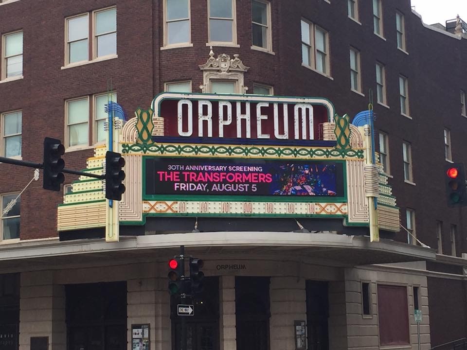
Highlights include Orpheum Theatre, John Mack Bridge, Kansas Firefighters Museum and Wichita - Sedgwick County Historical Museum.
July is the warmest month, with average highs of 93°F; January lows average 22°F.
Weather in Wichita
Forecast from the National Weather Service. Full forecast
About Wichita
Wichita is the most populous city in the U.S. state of Kansas and the county seat of Sedgwick County. As of the 2020 census, the population of the city was 397,532, and the Wichita metropolitan area had a population of 647,610. It is located in south-central Kansas along the Arkansas River.
From the Wikipedia article Wichita, Kansas (this version), under CC BY-SA 4.0.
Things to do9
Orpheum Theatre
Cinema and theater · National Register of Historic Places · 0.7 mi
Movie theater in Wichita, Kansas, United States

John Mack Bridge
Bridge · National Register of Historic Places · 3.2 mi
Historic road bridge in Wichita, Kansas, United States


Joyland Amusement Park
Monument and historic site · 4.1 mi
Former American amusement park

Wichita State University
School · 3.7 mi
Public university in Wichita, Kansas, U.S.
Wild West World
Monument and historic site · 9.0 mi
Former Wild West theme park in Park City, Kansas, United States
Museums and landmarks50

Wichita - Sedgwick County Historical Museum
Museum · 0.7 mi
204 South Main Street, Wichita
Tu-Fr 11:00-16:00; Sa,Su 13:00-17:00

Administration Building
Monument and historic site · National Register of Historic Places · 5.7 mi
Building in Kansas, United States

Allen-Lambe House
Monument and historic site · National Register of Historic Places · 3.1 mi
Historic house in Wichita, Kansas

Arkansas Valley Lodge No. 21, Prince Hall Masons
Monument and historic site · National Register of Historic Places · 0.7 mi
Historic building in Wichita, Kansas, USA
B. H. Campbell House
Monument and historic site · National Register of Historic Places · 1.2 mi
Historic home in Wichita, Kansas
Bitting Building
Monument and historic site · National Register of Historic Places · 0.6 mi
Office building in Wichita, Kansas
Bitting Historic District
Monument and historic site · National Register of Historic Places · 0.7 mi
Historic district in Wichita, Kansas
Carey House
Monument and historic site · National Register of Historic Places · 0.9 mi
Historic building in Wichita, Kansas
Dunbar Theatre
Cinema and theater · National Register of Historic Places · 1.6 mi
Former movie theater in Wichita, Kansas, United States
Engine House No. 6
Monument and historic site · National Register of Historic Places · 1.5 mi
Historic firehouse in Wichita, Kansas, USA


Governor L. D. Lewelling House
Monument and historic site · National Register of Historic Places · 1.3 mi
House in Wichita, Kansas
38 more on the map.
Parks, trails and playgrounds65

McAdams Park
Park · 2.1 mi
Park in the United States of America
1329 East 16th Street North, Wichita
Mo-Su 06:00-24:00

Pat Garcia Veterans Memorial Park
Park · 2.9 mi
2610 North Wellington Place, Wichita
Mo-Su 06:00-24:00
53 more on the map.
Restaurants and cafes166

Bella Vita Bistro
Restaurant · Italian · 2.2 mi
120 North West Street, Wichita
Mo-Sa 17:00-21:00, Fr 11:00-14:00
Burger Central
Restaurant · Burger, Sandwich · 1.8 mi
3302 West Central Avenue
Mo-Th 11:00-20:30; Fr,Sa 11:00-20:45; Su 11:00-14:45

Coffee Daze
Cafe · Coffee Shop, Pastry · 2.8 mi
3236 East Douglas Avenue, Wichita
Su 07:00-17:00; Mo-Fr 06:30-18:30; Sa 07:00-18:30
Copper Oven Cafe
Restaurant · Breakfast · 1.8 mi
2409 West 13th Street North, Wichita
Tu-Sa 07:00-14:00
Doo-Dah Diner
Restaurant · Breakfast, American · 0.9 mi
206 E Kellog St, Wichita
Su 08:00-14:00; Mo-Fr 07:00-14:00; Sa 08:00-14:00
Dragon City Chinese Restaurant
Restaurant · Chinese · 1.6 mi
3008 West Central Avenue
Mo-Th 10:30-21:30; Fr-Sa 10:30-22:00; Su 11:00-21:30
M & M Bierock
Restaurant · Corporate Catering · 2.0 mi
2065 East Central Avenue, Wichita
Mo-Fr 10:30-18:00; Sa 10:30-15:00
Old Chicago
Restaurant · Pizza · 1.1 mi
300 North Mead Street, Wichita
Su-Th 11:00-25:00; Fr-Sa 11:00-25:00
Picasso's Pizzeria
Restaurant · 0.4 mi
Welcome to Picasso's Pizzeria! Serving New York Style Thin Crust slices from our 26" pizza baked in a brick oven. Our sauce and dough...
621 West Douglas Avenue
Tu-Th 11:00-21:00; Fr, Sa 11:00-22:00; Su 11:00-20:00
Larcher's Market
Restaurant · 2.9 mi
3555 East Douglas Avenue
Mo-Th 07:00-19:00; Fr-Sa 07:00-20:00; Su 07:00-15:00
154 more on the map.
Where to stay29
Courtyard by Marriott Wichita at Old Town
Motel and hotel · 1.1 mi
820 East 2nd Street North, Wichita
Coratel Inn & Suites By Jasper Wesley Hospital
Motel and hotel · 2.8 mi
3343 East Central Avenue, Wichita
Drury Plaza Hotel Broadview Wichita
Motel and hotel · 0.4 mi
400 West Douglas Avenue, Wichita
Churches and places of worship165
Calvary Baptist Church
Church · National Register of Historic Places · 0.6 mi
Cathedral of the Immaculate Conception
Church · Roman Catholic · 0.8 mi
307 East Central Avenue, Wichita
Fairmount Congregational Church
Church · National Register of Historic Places · 3.3 mi
Holy Savior Roman Catholic Church
Church · Roman Catholic · 2.9 mi
3000 East 13th Street North, Wichita
New Covenant United Methodist Church
Church · United Methodist · 0.8 mi
1718 West Douglas Avenue, Witchita
The Source Wichita
Church · Nondenominational · 0.6 mi
445 North Market Street, Wichita
First Presbyterian Church
Church · Presbyterian · 0.8 mi
525 North Broadway Street, Wichita
Shopping31
Gas and EV charging31
Schools, colleges and libraries100
Healthcare17
Map of Wichita
250 places. The map loads OpenStreetMap tiles when you open it.
Climate by month
Monthly table
| Month | High | Low | Rain | Snow |
|---|---|---|---|---|
| Jan | 44°F | 22°F | 0.8 in | 2.7 in |
| Feb | 49°F | 26°F | 1.2 in | 3.6 in |
| Mar | 59°F | 36°F | 2.3 in | 2.1 in |
| Apr | 68°F | 45°F | 3.1 in | 0.2 in |
| May | 78°F | 56°F | 5.2 in | 0.0 in |
| Jun | 88°F | 66°F | 4.9 in | 0.0 in |
| Jul | 93°F | 70°F | 4.0 in | 0.0 in |
| Aug | 91°F | 69°F | 4.3 in | 0.0 in |
| Sep | 83°F | 60°F | 3.0 in | 0.0 in |
| Oct | 71°F | 47°F | 2.9 in | 0.2 in |
| Nov | 57°F | 35°F | 1.4 in | 0.8 in |
| Dec | 46°F | 25°F | 1.2 in | 3.1 in |
U.S. Climate Normals 1991-2020 for Wichita 72450 (6 mi away), NOAA NCEI.
People and cost of living
American Community Survey 5-year estimates, 2020-2024, U.S. Census Bureau. Estimates have margins of error, larger for small towns.
Disaster history
Sedgwick County has had 10 federal disaster declarations since 2000, most often for severe storms.
- 2020-03-29: Covid-19 Pandemic (Biological)
- 2020-03-13: Covid-19 (Biological)
- 2016-10-20: Severe Storms And Flooding (Severe Storm)
- 2012-05-24: Severe Storms, Tornadoes, Straight-Line Winds, And Flooding (Severe Storm)
- 2009-09-30: Severe Storms And Flooding (Severe Storm)
- 2008-02-01: Severe Winter Storms (Severe Storm)
OpenFEMA disaster declarations summaries.
Getting there and nearby towns
Wichita Dwight D. Eisenhower National Airport (ICT) is the nearest airport with scheduled flights listed in OpenStreetMap, 5 miles away.
- Eastborough 5 mi east, about 8 min by car
- Oaklawn-Sunview 6 mi southeast, about 10 min by car
- McConnell AFB 6 mi southeast, about 10 min by car
- Bel Aire 8 mi northeast, about 13 min by car
- Park City 8 mi north, about 13 min by car
- Maize 8 mi northwest, about 14 min by car
- Haysville 9 mi south, about 14 min by car
- Kechi 9 mi northeast, about 14 min by car
- Derby 10 mi southeast, about 17 min by car
- Valley Center 10 mi north, about 16 min by car
Drive times are estimates from straight-line distance, not routes.
Local news
Headlines from INDB, the NEMICO news database.
Reviews, tips and questions
Loading what members have shared...
Sources and licences
- NCES EDGE (Public domain): public schools
- NOAA NCEI U.S. Climate Normals 1991-2020 (Public domain): climate by month
- OpenFEMA (Public domain): disaster declarations
- OpenStreetMap contributors (ODbL 1.0): places, airports, map data
- U.S. Census Bureau (Public domain): population, income, housing, education, commute
- Wikidata (CC0 1.0): elevation, founding date, time zone, website, landmarks and historic places
- Wikimedia Commons (see each image): photos
- Wikipedia (CC BY-SA 4.0): overview and history text
Photo credits
- Wichita, Kansas skyline aerial view, Quintin Soloviev, CC BY 4.0
- Wichita April 2012 (7111394923), PaulAdamsPhotography from Parrish, FL, United States, CC BY 2.0
- Orpheum Witchita 2016, Jazz921, CC BY-SA 4.0
- Calvary Baptist Church on Water Street., erect 1917. Wichita, Kansas., UNOBUDO, CC BY-SA 3.0
- Grace Methodist Episcopal Church, Jeffrey Beall, CC BY 3.0
- Arkansas Valley Lodge No 21, Prince Hall Masons, Judy Handley, CC BY-SA 3.0
- Fairmount Church (SE Sideview), UNOBUDO, CC BY-SA 3.0
- KAM snow 1200, David G. Keith, CC BY-SA 3.0
- Allen-Lambe House, Jeffrey Beall, CC BY 3.0
- Governor L. D. Lewelling House, Jeffrey Beall, CC BY 3.0
- Riverview Apartments, Jeffrey Beall, CC BY 3.0
- Dji fly 20250601 203234 199 1748828399741 photo optimized, Popcorn700, CC BY-SA 4.0
- Women's March 2016 (37691517022), Rachel Miles from Manhattan, KS, USA, CC BY-SA 2.0
- Women's March 2016 (37053331823), Rachel Miles from Manhattan, KS, USA, CC BY-SA 2.0
- Women's March 2016 (37691517552), Rachel Miles from Manhattan, KS, USA, CC BY-SA 2.0
- Women's March 2016 (37053331273), Rachel Miles from Manhattan, KS, USA, CC BY-SA 2.0
- Women's March 2016 (37053331173), Rachel Miles from Manhattan, KS, USA, CC BY-SA 2.0
- Women's March 2016 (37053331103), Rachel Miles from Manhattan, KS, USA, CC BY-SA 2.0
- Women's March 2016 (37691510542), Rachel Miles from Manhattan, KS, USA, CC BY-SA 2.0
- U.S.S. Dorado SS-248, Trolinger, CC BY-SA 4.0
- Women's March 2016 (37691509582), Rachel Miles from Manhattan, KS, USA, CC BY-SA 2.0
- Women's March 2016 (37691505232), Rachel Miles from Manhattan, KS, USA, CC BY-SA 2.0
- Women's March 2016 (37465776030), Rachel Miles from Manhattan, KS, USA, CC BY-SA 2.0
- Women's March 2016 (37691506112), Rachel Miles from Manhattan, KS, USA, CC BY-SA 2.0
- Women's March 2016 (37691506882), Rachel Miles from Manhattan, KS, USA, CC BY-SA 2.0
- Women's March 2016 (37465777220), Rachel Miles from Manhattan, KS, USA, CC BY-SA 2.0
- Women's March 2016 (37465774670), Rachel Miles from Manhattan, KS, USA, CC BY-SA 2.0
- Women's March 2016 (37465777650), Rachel Miles from Manhattan, KS, USA, CC BY-SA 2.0
- Women's March 2016 (37053304293), Rachel Miles from Manhattan, KS, USA, CC BY-SA 2.0
- Women's March 2016 (37465773980), Rachel Miles from Manhattan, KS, USA, CC BY-SA 2.0
- Women's March 2016 (37691498612), Rachel Miles from Manhattan, KS, USA, CC BY-SA 2.0
- Women's March 2016 (37053320223), Rachel Miles from Manhattan, KS, USA, CC BY-SA 2.0
- Women's March 2016 (37691499742), Rachel Miles from Manhattan, KS, USA, CC BY-SA 2.0
- Women's March 2016 (37691511362), Rachel Miles from Manhattan, KS, USA, CC BY-SA 2.0
- Women's March 2016 (37053304953), Rachel Miles from Manhattan, KS, USA, CC BY-SA 2.0
- Women's March 2016 (37691512092), Rachel Miles from Manhattan, KS, USA, CC BY-SA 2.0
- Women's March 2016 (37053319563), Rachel Miles from Manhattan, KS, USA, CC BY-SA 2.0
- Women's March 2016 (37691512282), Rachel Miles from Manhattan, KS, USA, CC BY-SA 2.0
- Women's March 2016 (37691512872), Rachel Miles from Manhattan, KS, USA, CC BY-SA 2.0
- Women's March 2016 (37691513672), Rachel Miles from Manhattan, KS, USA, CC BY-SA 2.0


Page built October 30, 2026. Spotted a mistake? Tell us or suggest a place.