
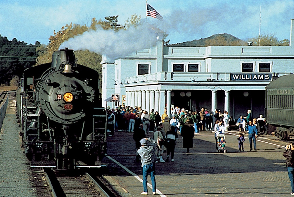


Williams, Arizona
Williams is a city of 3,369 people in Coconino County, Arizona, founded in 1881.
Why visit Williams
Townapedia lists 20 museums and landmarks, 4 parks and trails, 27 places to eat, 40 places to stay and 15 attractions in and around town.
Highlights include Bearizona Wildlife Park, Bearizona, Camp Clover Ranger Station and Poozeum.
July is the warmest month, with average highs of 84°F; December lows average 21°F, and about 65 inches of snow fall in a normal year.
Weather in Williams
Forecast from the National Weather Service. Full forecast
About Williams
Williams is a city in Coconino County, Arizona, United States, located west of Flagstaff. As of the 2020 census, Williams had a population of 3,202. It lies on the routes of Historic Route 66 and Interstate 40. It is also the southern terminus of the Grand Canyon Railway, which takes visitors to Grand Canyon Village.
From the Wikipedia article Williams, Arizona (this version), under CC BY-SA 4.0.
Things to do15


3 more on the map.
Museums and landmarks20

Camp Clover Ranger Station
Monument and historic site · National Register of Historic Places · 2.1 mi
Built in 1934 by the Civilian Conservation Corps

Poozeum
Museum · 0.4 mi
Coprolite museum in Williams, Arizona, U.S.
109 West Railroad Avenue, Williams
We-Su 09:00-17:00


Urban Route 66, Williams
Monument and historic site · National Register of Historic Places · 0.5 mi
Historic area in Arizona, US

Williams Historic Business District
Monument and historic site · National Register of Historic Places · 0.4 mi
Historic district in Williams, Arizona, United States
Williams Residential Historic District
Monument and historic site · National Register of Historic Places
Historic district in Williams, Arizona
Barney Flat Historic Railroad Logging Landscape
Monument and historic site · National Register of Historic Places · 6.5 mi
8 more on the map.
Parks, trails and playgrounds4

Elephant Rocks Golf Course Williams
Golf course · 2.6 mi
18 hole Par 72
2200 Country Club Drive, Williams


Restaurants and cafes27


Historic Brewing Bottle House
Bar and pub · Mexican · 0.4 mi
141 West Railroad Avenue, Williams
Mo-Fr 12:00+; Sa,Su 11:00+

Pine Country Restaurant
Diner · American · 0.4 mi
107 North Grand Canyon Boulevard, Williams
Mo-Su 07:00-21:00
Rod's Steak House
Restaurant · Steak House · 0.4 mi
301 East Route 66, Williams
Tu-Th 16:00-21:00; Fr-Sa 16:00-22:00
Rulu's 66 Bar & Grill
Bar and pub · 0.4 mi
514 East Route 66, Williams
Mo 09:00-21:00; Tu-Su 07:00-21:00; Th 07:00-17:00
Goldies Route 66 Diner
Diner · American · 0.4 mi
425 East Route 66, Williams
07:00-21:00
Old Smokeys Restaurant
Diner · American · 0.4 mi
125 West Route 66
Mo-Su 07:00-21:00

15 more on the map.
History
Founded in 1881, Williams was named for William Sherley "Old Bill" Williams (1787–1849), a famous trapper, trader, scout and mountain man, who often trapped in the area. A statue of "Old Bill" stands in Monument Park, located on the west side of the city. The large mountain directly to the south is named Bill Williams Mountain. The city was incorporated on July 9, 1901.
Williams was the last city whose section of Route 66 was bypassed, due to lawsuits that kept the last section of Interstate 40 in Arizona from being built around the city. After settlements called for the state to build three Williams exits, the suits were dropped and I-40 was completed. On October 13, 1984, Interstate 40 was opened around the town and newspapers the next day reported the essential end of US 66. The following year, Route 66 was decommissioned.
The Williams Historic Business District and Urban Route 66, Williams were added to the National Register of Historic Places in 1984 and 1989, respectively.
From the History section of Williams, Arizona on Wikipedia, under CC BY-SA 4.0.
Where to stay40
Churches and places of worship3
First Methodist Episcopal Church and Parsonage
Church · National Register of Historic Places
Shopping5
Gas and EV charging7
Schools, colleges and libraries6
Map of Williams
127 places. The map loads OpenStreetMap tiles when you open it.
Climate by month
Monthly table
| Month | High | Low | Rain | Snow |
|---|---|---|---|---|
| Jan | 47°F | 21°F | 2.2 in | 16.8 in |
| Feb | 49°F | 23°F | 2.6 in | 12.4 in |
| Mar | 56°F | 27°F | 2.0 in | 11.1 in |
| Apr | 62°F | 31°F | 0.9 in | 5.7 in |
| May | 71°F | 39°F | 0.8 in | 0.1 in |
| Jun | 82°F | 48°F | 0.4 in | 0.0 in |
| Jul | 84°F | 54°F | 3.0 in | 0.0 in |
| Aug | 82°F | 52°F | 3.4 in | 0.0 in |
| Sep | 76°F | 47°F | 1.6 in | 0.0 in |
| Oct | 67°F | 36°F | 1.6 in | 0.7 in |
| Nov | 56°F | 28°F | 1.3 in | 4.8 in |
| Dec | 47°F | 21°F | 1.9 in | 13.5 in |
U.S. Climate Normals 1991-2020 for Williams Hcn (1 mi away), NOAA NCEI.
People and cost of living
American Community Survey 5-year estimates, 2020-2024, U.S. Census Bureau. Estimates have margins of error, larger for small towns.
Disaster history
Coconino County has had 19 federal disaster declarations since 2000, most often for fires.
- 2022-06-12: Pipeline Fire (Fire)
- 2022-04-19: Tunnel 2 Fire (Fire)
- 2021-09-13: Severe Storms And Flooding (Flood)
- 2020-04-04: Covid-19 Pandemic (Biological)
- 2020-03-13: Covid-19 (Biological)
- 2019-07-22: Museum Fire (Fire)
OpenFEMA disaster declarations summaries.
Getting there and nearby towns
Valle Airport (VLE) is the nearest airport with scheduled flights listed in OpenStreetMap, 28 miles away.
- Parks 12 mi east, about 20 min by car
- Kaibab Estates West 18 mi west, about 29 min by car
- Fort Valley 26 mi east, about 41 min by car
- Flagstaff 32 mi east, about 52 min by car
- Mountainaire 32 mi east, about 52 min by car
- Sedona 35 mi southeast, about 56 min by car
- Clarkdale 35 mi south, about 57 min by car
- Cottonwood 36 mi south, about 58 min by car
- Chino Valley 37 mi south, about 1 h by car
- Verde Village 38 mi south, about 1 h by car
Drive times are estimates from straight-line distance, not routes.
Local news
Headlines from INDB, the NEMICO news database.
Reviews, tips and questions
Loading what members have shared...
Sources and licences
- NCES EDGE (Public domain): public schools
- NOAA NCEI U.S. Climate Normals 1991-2020 (Public domain): climate by month
- OpenFEMA (Public domain): disaster declarations
- OpenStreetMap contributors (ODbL 1.0): places, airports, map data
- U.S. Census Bureau (Public domain): population, income, housing, education, commute
- Wikidata (CC0 1.0): elevation, founding date, time zone, website, landmarks and historic places
- Wikimedia Commons (see each image): photos
- Wikipedia (CC BY-SA 4.0): overview and history text
Photo credits
- WilliamsDepot WilliamsAZ, Unknown author, Public domain
- Williams Residential HD NRHP 97001603 Coconino County, AZ, Jon Roanhaus, CC BY-SA 3.0
- Odd Partnership, Williams, AZ 2002 (6680190277), inkknife_2000 (7.5 million views +), CC BY-SA 2.0
- Williams, AZ 86046, USA - panoramio (14), Roman Eugeniusz, CC BY-SA 3.0
- The Lodge on Route 66, Williams, AZ (16704130847), Scottb211 from Gaylord, Michigan, U.S.A., CC BY 2.0
- The Lodge on Route 66, Williams, AZ (16910173532), Scottb211 from Gaylord, Michigan, U.S.A., CC BY 2.0
- The Lodge on Route 66, Williams, AZ (16723759488), Scottb211 from Gaylord, Michigan, U.S.A., CC BY 2.0
- The Lodge on Route 66, Williams, AZ (16911436285), Scottb211 from Gaylord, Michigan, U.S.A., CC BY 2.0
- The Lodge on Route 66, Williams, AZ (16911456005), Scottb211 from Gaylord, Michigan, U.S.A., CC BY 2.0
- The Lodge on Route 66, Williams, AZ (16704112367), Scottb211 from Gaylord, Michigan, U.S.A., CC BY 2.0
- The Lodge on Route 66, Williams, AZ (16289054864), Scottb211 from Gaylord, Michigan, U.S.A., CC BY 2.0
- The Lodge on Route 66, Williams, AZ (16885547006), Scottb211 from Gaylord, Michigan, U.S.A., CC BY 2.0
- The Lodge on Route 66, Williams, AZ (16910197752), Scottb211 from Gaylord, Michigan, U.S.A., CC BY 2.0
- The Lodge on Route 66, Williams, AZ (16910175952), Scottb211 from Gaylord, Michigan, U.S.A., CC BY 2.0
- The Lodge on Route 66, Williams, AZ (16910206862), Scottb211 from Gaylord, Michigan, U.S.A., CC BY 2.0
- The Lodge on Route 66, Williams, AZ (16911451985), Scottb211 from Gaylord, Michigan, U.S.A., CC BY 2.0
- Get your pic's on Route 66 Williams AZ - panoramio, Loco Steve, CC BY 3.0
- Downtowner Rodeway Inn parking lot Williams AZ 2026-04-07 10-59-55, G. Edward Johnson, CC BY 4.0
- The Lodge on Route 66 Williams AZ 2026-04-07 10-59-10, G. Edward Johnson, CC BY 4.0
- Grand Motel Williams AZ 2026-04-07 10-58-08, G. Edward Johnson, CC BY 4.0
- Williams, Arizona, Christophe Krief, CC BY-SA 4.0
- Celilo Inn front Williams AZ 2026-04-07 11-00-19, G. Edward Johnson, CC BY 4.0
- Americas Best Value Inn Williams AZ 2026-04-07 10-56-33, G. Edward Johnson, CC BY 4.0
- Williams-Streetscape, Steven C. Price, CC BY-SA 4.0
- Camp Clover Ranger Station 2012-09-15 11-45-46, jdpreas, CC BY-SA 3.0
- Community United Methodist Church 1, Mx. Granger, CC0
- Community United Methodist Church 2, Mx. Granger, CC0
- Built for the railroad - panoramio, Stephen Edmonds, CC BY-SA 3.0
- DelSue Motor Inn NRHP 98000356 Coconino County, AZ, Jon Roanhaus, CC BY-SA 3.0
- Pete's Route 66 Gas Station Museum - panoramio, Loco Steve, CC BY 3.0
- Pete's gas station museum - panoramio, halfuur, CC BY 3.0
- South Rims Wine & Beer Garage (25912077326), Scottb211 from Gaylord, Michigan, U.S.A., CC BY 2.0
- South Rims Wine & Beer Garage (25817183132), Scottb211 from Gaylord, Michigan, U.S.A., CC BY 2.0
- South Rims Wine & Beer Garage (25817113922), Scottb211 from Gaylord, Michigan, U.S.A., CC BY 2.0
- South Rims Wine & Beer Garage (25912029066), Scottb211 from Gaylord, Michigan, U.S.A., CC BY 2.0
- South Rims Wine & Beer Garage (25309200393), Scottb211 from Gaylord, Michigan, U.S.A., CC BY 2.0
- South Rims Wine & Beer Garage (25817173542), Scottb211 from Gaylord, Michigan, U.S.A., CC BY 2.0
- South Rims Wine & Beer Garage (25911992276), Scottb211 from Gaylord, Michigan, U.S.A., CC BY 2.0
- South Rims Wine & Beer Garage (25912067626), Scottb211 from Gaylord, Michigan, U.S.A., CC BY 2.0
- South Rims Wine & Beer Garage (25309209713), Scottb211 from Gaylord, Michigan, U.S.A., CC BY 2.0


Page built October 30, 2026. Spotted a mistake? Tell us or suggest a place.