


Why visit Williston
Townapedia lists 4 museums and landmarks, 10 parks and trails, 14 places to eat and 1 place to stay in and around town.
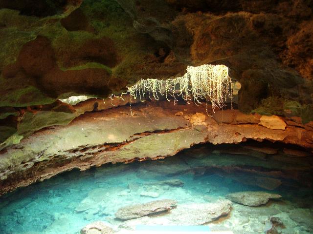
Highlights include Citizens Bank and Devil's Den.
Weather in Williston
Forecast from the National Weather Service. Full forecast
About Williston
Williston is a city in Levy County, Florida, United States. It is part of the Nature Coast. As of the 2020 census, it had a population of 2,976, up from 2,768 at the 2010 census. It is part of the Gainesville, Florida Metropolitan Statistical Area.
From the Wikipedia article Williston, Florida (this version), under CC BY-SA 4.0.
Museums and landmarks4


Citizens Bank
Monument and historic site · National Register of Historic Places · 0.5 mi
Site on the U.S. National Register of Historic Places in Williston, Florida
Devil's Den
Monument and historic site · 0.5 mi
Sinkhole/underground river in Florida, US

Cedar Lakes Woods and Gardens
Monument and historic site · 2.3 mi
4990 Northeast 180th Avenue, Williston
Devil's Den
Monument and historic site · 2.2 mi
5390 Northeast 180th Avenue, Williston
Parks, trails and playgrounds10

Webber Cedar Lakes Estates Conservation Easement
Hiking and trails · 2.3 mi
4990 Northeast 180th Avenue, Williston


Restaurants and cafes14



Green Shutters
Diner · American · 1.0 mi
706 West Noble Avenue, Williston

Subway
Fast food · Sandwich · 0.9 mi
611 West Noble Avenue, Williston
Mo-Th 08:00-21:00; Fr-Sa 08:00-22:00; Su 10:00-21:00
2 more on the map.
Where to stay1

History
Williston was established in 1853 by J.M. Willis, who named it after himself. It was officially incorporated as the "Town of Williston" in 1897, but was reincorporated as the City of Williston on June 2, 1929.
On May 7, 2016, the first known fatal accident involving a self-driving vehicle occurred at the intersection of U.S. 27 and Northeast 140th Court in Williston. A 2015 Tesla Model S driven by 40 year old Joshua D. Brown of Canton, Ohio struck the side of a tractor-trailer turning left in front of Brown when the car's autonomous features failed to distinguish the white side of the truck against a bright sky. Brown was pronounced dead by Levy County Fire Rescue at the scene.
From the History section of Williston, Florida on Wikipedia, under CC BY-SA 4.0.
Churches and places of worship18
Shopping5
Gas and EV charging4
Schools, colleges and libraries6
Healthcare3
Map of Williston
65 places. The map loads OpenStreetMap tiles when you open it.
People and cost of living
American Community Survey 5-year estimates, 2020-2024, U.S. Census Bureau. Estimates have margins of error, larger for small towns.
Disaster history
Levy County has had 36 federal disaster declarations since 2000, most often for hurricanes.
- 2026-10-09: Hurricane Isaias (Tropical Storm)
- 2026-04-23: Cow Creek Fire (Fire)
- 2024-10-11: Hurricane Milton (Hurricane)
- 2024-10-07: Hurricane Milton (Hurricane)
- 2024-09-28: Hurricane Helene (Hurricane)
- 2024-09-24: Tropical Storm Helene (Tropical Storm)
OpenFEMA disaster declarations summaries.
Getting there and nearby towns
Ocala International Airport (OCF) is the nearest airport with scheduled flights listed in OpenStreetMap, 20 miles away.
- East Bronson 10 mi northwest, about 16 min by car
- Bronson 12 mi west, about 20 min by car
- Newberry 20 mi northwest, about 32 min by car
- Gainesville 21 mi north, about 33 min by car
- Rainbow Springs 21 mi south, about 33 min by car
- On Top of the World 22 mi southeast, about 35 min by car
- Ocala 23 mi southeast, about 37 min by car
- Dunnellon 23 mi south, about 37 min by car
- Liberty Triangle 26 mi southeast, about 41 min by car
- Alachua 27 mi north, about 43 min by car
Drive times are estimates from straight-line distance, not routes.
Local news
Headlines from INDB, the NEMICO news database.
Reviews, tips and questions
Loading what members have shared...
Sources and licences
- OpenFEMA (Public domain): disaster declarations
- OpenStreetMap contributors (ODbL 1.0): places, airports, map data
- U.S. Census Bureau (Public domain): population, income, housing, education, commute
- Wikidata (CC0 1.0): elevation, founding date, time zone, website, landmarks and historic places
- Wikimedia Commons (see each image): photos
- Wikipedia (CC BY-SA 4.0): overview and history text
Photo credits
- Williston intersection01, Ebyabe, CC BY 2.5
- Williston Old Citizens Bank01, Ebyabe, CC BY-SA 3.0
- Devils-Den-Small, Eric Beach, CC BY-SA 3.0
Page built October 30, 2026. Spotted a mistake? Tell us or suggest a place.