



Why visit Wilton
Townapedia lists 5 museums and landmarks and 2 parks and trails in and around town.
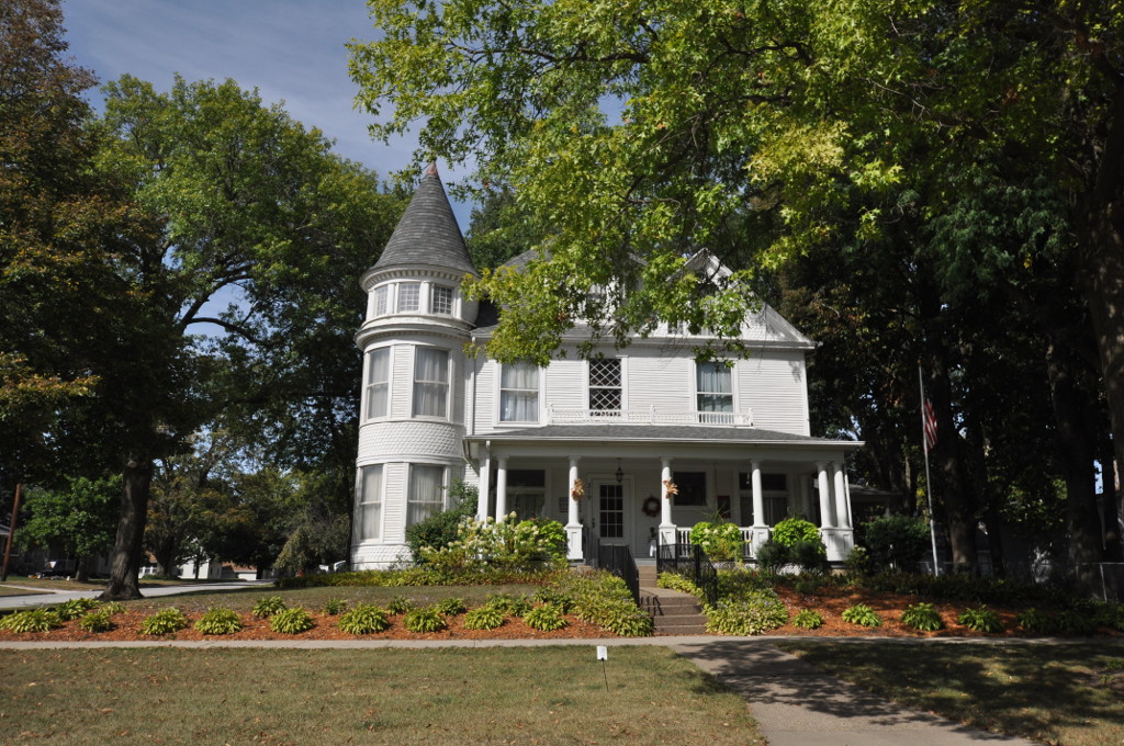
Highlights include Chicago, Rock Island and Pacific Railroad-Wilton Depot and Doctor Alexander R. (A.R.) and Louisa J. Leith House.
July is the warmest month, with average highs of 84°F; January lows average 14°F, and about 29 inches of snow fall in a normal year.
Weather in Wilton
Forecast from the National Weather Service. Full forecast
About Wilton
Wilton (formerly Wilton Junction) is a city in Cedar and Muscatine counties in the U.S. state of Iowa. The population was 2,924 at the time of the 2020 census. The Muscatine County portion of Wilton is part of the Muscatine Micropolitan Statistical Area.
From the Wikipedia article Wilton, Iowa (this version), under CC BY-SA 4.0.
Museums and landmarks5

Chicago, Rock Island and Pacific Railroad-Wilton Depot
Monument and historic site · National Register of Historic Places · 0.5 mi
Former M&M RR station in Wilton, Iowa

Doctor Alexander R. (A.R.) and Louisa J. Leith House
Monument and historic site · National Register of Historic Places
Historic building located in Wilton, Iowa, United States
Henry E. and Ella M. (Knott) Nicolaus House
Monument and historic site · National Register of Historic Places
Historic building located in Wilton, Iowa, United States
Wilton Commercial Historic District
Monument and historic site · National Register of Historic Places · 0.4 mi
Nationally recognized historic district located in Wilton, Iowa, United States

Wilton Candy Kitchen
Monument and historic site · National Register of Historic Places · 0.4 mi
Parks, trails and playgrounds2

Churches and places of worship6



Schools, colleges and libraries6


History
The first settler to build a home in the area that was to be known as Wilton in the new state of Iowa (1846) was Mr. Christian Marolf who came in July 1849, and erected of a small log house opposite the German Lutheran church. When he built his home Mr. Marolf could only see the home of Mr. Stearns just west of town on the south side of the Moscow road. Mr. Marolf was soon followed by Mr. Ben Maurer in 1850 whose land now comprises North Wilton and Peter Marolf in 1851, which is now known as Marolf's addition. North Wilton is at present (1947) not within the corporate limits of Wilton. The city was once home to the Wilton German English College from 1894 to 1905. The campus of the college was later turned into City Park, and some of the college's buildings remain to this day.
From the History section of Wilton, Iowa on Wikipedia, under CC BY-SA 4.0.
Map of Wilton
19 places. The map loads OpenStreetMap tiles when you open it.
Climate by month
Monthly table
| Month | High | Low | Rain | Snow |
|---|---|---|---|---|
| Jan | 31°F | 14°F | 1.4 in | 7.0 in |
| Feb | 35°F | 18°F | 1.6 in | 8.6 in |
| Mar | 48°F | 28°F | 2.4 in | 4.0 in |
| Apr | 61°F | 39°F | 3.6 in | 0.7 in |
| May | 72°F | 51°F | 4.9 in | 0.0 in |
| Jun | 81°F | 60°F | 5.4 in | 0.0 in |
| Jul | 84°F | 64°F | 4.4 in | 0.0 in |
| Aug | 82°F | 62°F | 4.0 in | 0.0 in |
| Sep | 76°F | 54°F | 3.5 in | 0.0 in |
| Oct | 64°F | 43°F | 2.9 in | 0.3 in |
| Nov | 49°F | 31°F | 2.2 in | 1.4 in |
| Dec | 36°F | 20°F | 2.0 in | 7.4 in |
U.S. Climate Normals 1991-2020 for Muscatine 2N (8 mi away), NOAA NCEI.
People and cost of living
American Community Survey 5-year estimates, 2020-2024, U.S. Census Bureau. Estimates have margins of error, larger for small towns.
Disaster history
Cedar County has had 13 federal disaster declarations since 2000, most often for severe storms.
- 2024-05-24: Severe Storms, Tornadoes, And Flooding (Severe Storm)
- 2020-08-17: Severe Storms (Severe Storm)
- 2020-03-23: Covid-19 Pandemic (Biological)
- 2020-03-13: Covid-19 (Biological)
- 2014-08-05: Severe Storms, Tornadoes, Straight-Line Winds, And Flooding (Severe Storm)
- 2013-07-31: Severe Storms, Tornadoes, And Flooding (Severe Storm)
OpenFEMA disaster declarations summaries.
Getting there and nearby towns
Muscatine Municipal Airport (MUT) is the nearest airport with scheduled flights listed in OpenStreetMap, 17 miles away.
- Durant 6 mi east, about 9 min by car
- Kent Estates 9 mi south, about 14 min by car
- Muscatine 12 mi south, about 19 min by car
- West Liberty 12 mi west, about 20 min by car
- Walcott 13 mi east, about 20 min by car
- Tipton 14 mi northwest, about 22 min by car
- Blue Grass 14 mi east, about 23 min by car
- Buffalo 16 mi southeast, about 26 min by car
- West Branch 17 mi west, about 28 min by car
- Davenport 22 mi east, about 35 min by car
Drive times are estimates from straight-line distance, not routes.
Local news
Headlines from INDB, the NEMICO news database.
Reviews, tips and questions
Loading what members have shared...
Sources and licences
- NCES EDGE (Public domain): public schools
- NOAA NCEI U.S. Climate Normals 1991-2020 (Public domain): climate by month
- OpenFEMA (Public domain): disaster declarations
- OpenStreetMap contributors (ODbL 1.0): places, airports, map data
- U.S. Census Bureau (Public domain): population, income, housing, education, commute
- Wikidata (CC0 1.0): elevation, founding date, time zone, website, landmarks and historic places
- Wikimedia Commons (see each image): photos
- Wikipedia (CC BY-SA 4.0): overview and history text
Photo credits
- Wilton, Iowa, Farragutful, CC BY-SA 3.0
- WiltonIA NicolausHouse, Magicpiano, CC BY-SA 4.0
- Wilton Candy Kitchen - Wilton, Iowa 2024, Robert Stinnett, CC BY 2.0
- LIFEchurch Wilton, Farragutful, CC BY-SA 4.0
- Wilton City Hall, Farragutful, CC BY-SA 3.0
- Wilton water tower, Farragutful, CC BY-SA 4.0
- Zion Lutheran Church - Wilton, Iowa 01, Farragutful, CC BY-SA 4.0
- Zion Lutheran Church - Wilton, Iowa 03, Farragutful, CC BY-SA 4.0
- Zion Lutheran Church - Wilton, Iowa 04, Farragutful, CC BY-SA 4.0
- Zion Lutheran Church - Wilton, Iowa 02, Farragutful, CC BY-SA 4.0
- Wilton United Methodist Church 06, Farragutful, CC BY-SA 4.0
- Wilton United Methodist Church 05, Farragutful, CC BY-SA 4.0
- Wilton United Methodist Church 02, Farragutful, CC BY-SA 4.0
- Wilton United Methodist Church 03, Farragutful, CC BY-SA 4.0
- Wilton United Methodist Church 01, Farragutful, CC BY-SA 4.0
- Bobby Kaufmann supporters, Wilton Iowa 2014, Gage Skidmore, CC BY-SA 2.0
- WiltonIA Depot, User:Magicpiano, CC BY-SA 4.0
- WiltonIA CandyKitchen, User:Magicpiano, CC BY-SA 4.0
- Leith House, Farragutful, CC BY-SA 4.0
- Leith Carriagehouse, Farragutful, CC BY-SA 4.0
- ISS020-E-13628 - View of Minnesota, Earth Science and Remote Sensing Unit , Lyndon B. Johnson Space Center, Public domain
- ISS050-E-39876 - View of Earth, Earth Science and Remote Sensing Unit , Lyndon B. Johnson Space Center, Public domain
- ISS038-E-63446 - View of Earth, Earth Science and Remote Sensing Unit , Lyndon B. Johnson Space Center, Public domain
- ISS050-E-51401 - View of Earth, Earth Science and Remote Sensing Unit , Lyndon B. Johnson Space Center, Public domain
- ISS038-E-63445 - View of Earth, Earth Science and Remote Sensing Unit , Lyndon B. Johnson Space Center, Public domain


Page built October 30, 2026. Spotted a mistake? Tell us or suggest a place.