
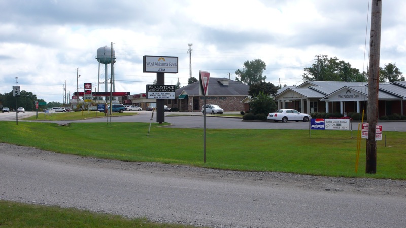


Woodstock, Alabama
Woodstock is a town of 1,218 people in Bibb County, Alabama, founded in 1826.
Why visit Woodstock
Townapedia lists 1 park or trail, 4 places to eat and 1 place to stay in and around town.
July is the warmest month, with average highs of 92°F; January lows average 34°F.
Weather in Woodstock
Forecast from the National Weather Service. Full forecast
About Woodstock
Woodstock is a town in Bibb and Tuscaloosa counties in the U.S. state of Alabama. Formerly known as North Bibb, by referendum in August 2000, the town adopted the name of a long-established local unincorporated community and, as of October 1, 2000, is now known officially as "Woodstock". As of the 2020 census, Woodstock had a population of 1,472.
From the Wikipedia article Woodstock, Alabama (this version), under CC BY-SA 4.0.
Parks, trails and playgrounds1

Restaurants and cafes4



Where to stay1

Churches and places of worship10

History
Bibb County, founded as Cahawba County in 1818, played an important role in the early industrial history of Alabama. Ironworks and foundries produced goods from the brown iron ore found on Roupes Creek. Woodstock, known as North Bibb until 2000, is a small town on the northern boundary of Bibb County. This community was once the center of a thriving railroad business.
Woodstock was first settled in the 1820s, with a formal land grant to William Houston on February 27, 1826. The settlement was established along the old Tuscaloosa to Huntsville stagecoach line. Woodstock got its name when Dr. J.U. Ray named it after the home of his ancestors, Woodstock, England. Ray's ancestors arrived in America from England at Jamestown, Virginia. In 1870, Ray built the first depot for the newly constructed Alabama-Chattanooga Railroad. After the Alabama Great Southern Railroad came the Louisville and Nashville Railroad. Each operated a depot in the area. In 1872, a line was installed down to West Blocton to ship the large abundance of coal found in the area. Woodstock became a break and storage yard for coal, red and brown iron ore and cotton. After the Civil War, rich iron ore deposits were mined. In 1872, Giles Edwards relocated to Woodstock from Tannehill and built a blast furnace to manufacture pig iron.
From the History section of Woodstock, Alabama on Wikipedia, under CC BY-SA 4.0.
Shopping1
Gas and EV charging6
Schools, colleges and libraries5
Healthcare1
Map of Woodstock
29 places. The map loads OpenStreetMap tiles when you open it.
Climate by month
Monthly table
| Month | High | Low | Rain | Snow |
|---|---|---|---|---|
| Jan | 56°F | 34°F | 5.4 in | 0.4 in |
| Feb | 61°F | 37°F | 5.4 in | 0.0 in |
| Mar | 68°F | 43°F | 5.4 in | 0.7 in |
| Apr | 76°F | 50°F | 5.1 in | 0.0 in |
| May | 83°F | 59°F | 4.5 in | 0.0 in |
| Jun | 89°F | 67°F | 4.5 in | 0.0 in |
| Jul | 92°F | 70°F | 4.8 in | 0.0 in |
| Aug | 92°F | 70°F | 4.0 in | 0.0 in |
| Sep | 87°F | 64°F | 3.5 in | 0.0 in |
| Oct | 77°F | 53°F | 3.3 in | 0.0 in |
| Nov | 66°F | 42°F | 4.5 in | 0.0 in |
| Dec | 58°F | 37°F | 5.2 in | 0.1 in |
U.S. Climate Normals 1991-2020 for Bessemer 3 Wsw (15 mi away), NOAA NCEI.
People and cost of living
American Community Survey 5-year estimates, 2020-2024, U.S. Census Bureau. Estimates have margins of error, larger for small towns.
Disaster history
Bibb County has had 16 federal disaster declarations since 2000, most often for hurricanes.
- 2024-09-26: Hurricane Helene (Hurricane)
- 2021-04-26: Severe Storms, Straight-Line Winds, And Tornadoes (Severe Storm)
- 2020-09-14: Hurricane Sally (Hurricane)
- 2020-03-29: Covid-19 Pandemic (Biological)
- 2020-03-13: Covid-19 (Biological)
- 2017-10-08: Hurricane Nate (Hurricane)
OpenFEMA disaster declarations summaries.
Getting there and nearby towns
Tuscaloosa National Airport (TCL) is the nearest airport with scheduled flights listed in OpenStreetMap, 27 miles away.
- Vance 5 mi southwest, about 9 min by car
- McCalla 9 mi northeast, about 15 min by car
- Bessemer 15 mi northeast, about 24 min by car
- Hueytown 15 mi northeast, about 25 min by car
- Helena 16 mi east, about 25 min by car
- Montevallo 18 mi east, about 30 min by car
- Cottondale 18 mi west, about 29 min by car
- Centreville 18 mi south, about 29 min by car
- Alabaster 19 mi east, about 30 min by car
- Tuscaloosa 22 mi west, about 36 min by car
Drive times are estimates from straight-line distance, not routes.
Local news
Headlines from INDB, the NEMICO news database.
Reviews, tips and questions
Loading what members have shared...
Sources and licences
- NCES EDGE (Public domain): public schools
- NOAA NCEI U.S. Climate Normals 1991-2020 (Public domain): climate by month
- OpenFEMA (Public domain): disaster declarations
- OpenStreetMap contributors (ODbL 1.0): places, airports, map data
- U.S. Census Bureau (Public domain): population, income, housing, education, commute
- Wikidata (CC0 1.0): elevation, founding date, time zone, website
- Wikimedia Commons (see each image): photos
- Wikipedia (CC BY-SA 4.0): overview and history text
Photo credits
- WoodstockAlabama, DwayneP, CC BY-SA 3.0
- Plestiodon fasciatus 213278739, Briggs Armstrong, CC BY 4.0
- Hydrophlox chrosomus - Tayton Alvis - 594690233, Tayton Alvis, CC BY 4.0
Page built October 30, 2026. Spotted a mistake? Tell us or suggest a place.